

Mori Atlas logo
Nature reserveGamilaroi Nature Reserve

Examining the ecological boundaries and rare botanical communities of the inland Brigalow Belt

Gamilaroi Nature Reserve: A Scientific Protected Landscape and Woodland Sanctuary in New South Wales

Gamilaroi Nature Reserve represents a critical protected enclave within the southern Brigalow Belt of New South Wales. This 113-hectare site features sandy red clay soils derived from quartzite, supporting a unique transition of vegetation that ranges from drier inland woodlands to species with coastal rainforest affinities. The reserve stands as one of the few natural refuges for the rare ooline tree, functioning as a specialized botanical sanctuary focused on habitat preservation.

nature reservebotanical conservationooline habitatBrigalow Beltinland New South WalesNorth West Slopes

Gamilaroi Nature Reserve

Nature reserve

Park overview

Structured park overview, official facts, and landscape profile for Gamilaroi Nature Reserve

Gamilaroi Nature Reserve park facts, protected area profile, and essential visitor context

Review the core facts for Gamilaroi Nature Reserve, including designation, size, terrain, visitor scale, habitats, and operating context in one park-focused overview.

About Gamilaroi Nature Reserve

Gamilaroi Nature Reserve is a small protected area in inland New South Wales, lying within the southern Brigalow Belt bioregion and the North West Slopes region. It is located southeast of the regional centre of Moree and south of the small locality of Terry Hie Hie, occupying a modest footprint of about 113 hectares. The reserve sits at an elevation of around 340 metres above sea level, on sandy red clay soils derived from re-crystallized quartzite and ferruginous sandstone. The surrounding climate is semi-arid to sub-humid, with annual rainfall averaging roughly 600 millimetres, placing the reserve in a transitional zone between wetter eastern woodlands and the drier western interior.

The reserve was established in May 1994 and is managed by the NSW National Parks and Wildlife Service under an IUCN Category IV classification, which designates it as a habitat and species management area. This international designation underscores the reserve's focus on targeted conservation of specific ecological values rather than broad landscape protection or recreation. The name Gamilaroi itself reflects the area's cultural context: it is a name for the local Kamilaroi Indigenous people whose traditional lands include this part of New South Wales.

From an ecological standpoint, Gamilaroi Nature Reserve occupies a fascinating transitional position. The plant community combines species typical of the drier western woodlands, such as wilga, white box, and belah, with elements of the shrub layer that have unexpected affinities with coastal rainforests further east. This blend of inland and coastal floristic influences makes the reserve scientifically interesting beyond its narrow ooline focus. The reserve is also one of seven sites in New South Wales where ooline occurs naturally, giving it a critical role in the long-term survival of this rare and threatened tree species.

Because its values are conservation-driven and biologically sensitive, the reserve is not promoted for recreation, and visits are not actively encouraged. This sets it apart from many other New South Wales protected areas that emphasize public access, scenic landscapes, or tourism infrastructure. Instead, Gamilaroi Nature Reserve functions primarily as a quiet, science-oriented refuge for ooline and its associated plant and animal communities, reflecting a model of protection centered on habitat and species management rather than visitor experience.

Quick facts and research context for Gamilaroi Nature Reserve

Gamilaroi Nature Reserve is a state-level protected nature reserve covering about 113 hectares in the North West Slopes of New South Wales, within the southern Brigalow Belt. It sits roughly 48 kilometres southeast of Moree at an elevation of around 340 metres above sea level and falls under the management of the NSW National Parks and Wildlife Service. Established in May 1994, the reserve is classified as an IUCN Category IV protected area, reflecting its focus on habitat and species management.

The reserve is recognized as one of only seven sites in New South Wales where the rare ooline tree is found naturally. Its conservation objective is tightly focused on preserving this species and its supporting plant community. Annual rainfall in the area averages about 600 millimetres, and the substrate consists of sandy red clay soils derived from re-crystallized quartzite and ferruginous sandstone.

Protection and recognition

Documented terrestrial conservation framework and international recognition facts

Gamilaroi Nature Reserve Protection Status and Territorial Management Records

Gamilaroi Nature Reserve maintains a documented terrestrial protection scope without imported international recognition sources. Review official designation records and management frameworks for this protected area.

Protection details

Protection scope
Terrestrial
Transboundary protection
No
Park context

Deeper park guide and search-rich context for Gamilaroi Nature Reserve

Gamilaroi Nature Reserve history, landscape, wildlife, and travel context

Explore Gamilaroi Nature Reserve through its history, landscape character, ecosystems, wildlife, conservation priorities, cultural context, and seasonal travel timing in a structured park guide built for atlas discovery and search intent.

Why Gamilaroi Nature Reserve stands out

Gamilaroi Nature Reserve is best known as one of the very few natural locations in New South Wales where the rare ooline tree still survives. This single defining feature drives the reserve's entire purpose: ooline conservation is the primary reason the area was set aside and remains the focus of its management. The reserve's small size and narrow botanical focus give it a strongly specialized identity within the New South Wales protected-area network. Because of this botanical rarity, the reserve is not promoted for recreation and attracts very little visitor traffic compared to more typical national parks or nature reserves. Its profile is therefore that of a quiet, science-oriented conservation site rather than a landscape-oriented destination, and it is primarily of interest for researchers studying ooline, Brigalow Belt vegetation, and threatened woodland species.
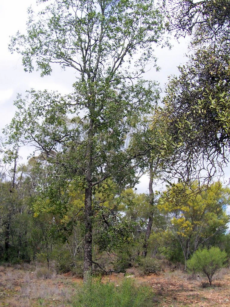
A tall Ooline tree with textured bark and green leaves standing in a dry, open woodland habitat with scrubby vegetation.
An Ooline tree, a rare species protected within the Gamilaroi Nature Reserve.

Gamilaroi Nature Reserve history and protected-area timeline

Gamilaroi Nature Reserve was formally established in May 1994 as a protected nature reserve under the New South Wales state system, managed by the NSW National Parks and Wildlife Service. Its creation was driven by the recognition that the area contained one of only a small number of natural sites in the state where ooline, a rare native tree, still survived. By formally reserving the land, the state government sought to give lasting protection to this species and its associated habitat, even at a landscape scale that is very small by national-park standards.

Before becoming a reserve, the land had a long history of human use that was very different from its current conservation role. The area once formed part of a travelling stock route and was used for grazing, exposing the vegetation to historical disturbance from livestock movement, clearing pressure, and trampling. These land-use pressures are part of the broader context behind woodland decline across the Brigalow Belt and help explain why so few ooline populations remain today. The transition from grazing land to a protected reserve in 1994 therefore represents a deliberate shift toward prioritizing the survival of a rare species over continued agricultural use.

Since its establishment, the reserve has continued to be defined by its conservation mission rather than by infrastructure development or tourism promotion. Its name, Gamilaroi, comes from the word used for the local Kamilaroi Indigenous people of the region, recognizing the broader cultural landscape in which the reserve sits even though the management focus remains ecological.

Gamilaroi Nature Reserve landscape and geographic character

Gamilaroi Nature Reserve sits within the gently undulating terrain of the North West Slopes of New South Wales, on the inland side of the Great Dividing Range's influence. Its elevation is about 340 metres above sea level, placing it well below the alpine and subalpine zones of the state but above the lower floodplains associated with major western river systems. The reserve sits roughly 48 kilometres southeast of Moree, in a transition zone between more elevated woodland country to the east and the broader dry inland plains further west.

The physical substrate of the reserve is one of its most distinctive landscape features. Soils are sandy red clays derived from re-crystallized quartzite and ferruginous sandstone, giving the ground a mineral character that supports a particular mix of woodland species. This geological background helps explain the unusual floristic blend found in the reserve, which combines plants typical of the drier western interior with elements that have affinities with coastal rainforests further east.

The vegetation structure reflects this transitional setting. The reserve's woodland canopy includes species such as white box and belah, while shrubs layer in vegetation that carries more eastern rainforest-derived elements. Overall, the landscape appears as a compact patch of inland woodland set within a wider matrix of agricultural and grazing land. Although the reserve is small, occupying only around 113 hectares, its landscape character is tightly bound to the rare botanical community it was set aside to protect.

Gamilaroi Nature Reserve ecosystems, habitats, and plant life

The vegetation of Gamilaroi Nature Reserve reflects a unique transitional ecology between the drier western woodlands and more easterly coastal rainforest influences. This unusual blend is one of the reserve's defining ecological features and is closely tied to its substrate of sandy red clay soils derived from re-crystallized quartzite and ferruginous sandstone. The woodland canopy includes characteristic inland species such as white box, a eucalyptus well adapted to the North West Slopes, and belah, a sheoak typical of drier inland areas. Wilga and mock olive add further structural diversity to the plant community.

The shrub layer is particularly notable for carrying plants with affinities to coastal rainforests in the east, which is unusual for an inland reserve at this elevation and latitude. This unusual combination of western woodland canopy and eastern rainforest-influenced shrub layer is part of what makes the reserve botanically distinctive and scientifically significant, especially in the context of the broader southern Brigalow Belt.

Rainfall in the area averages around 600 millimetres per year, placing the reserve within a sub-humid to semi-arid climatic band. The combination of modest rainfall, distinctive quartzite-derived soils, and a fragmented history shaped by grazing and stock routes has produced a plant community that is both ecologically rich and ecologically fragile. These conditions help explain why the reserve is managed primarily for conservation and why its small footprint carries disproportionately high botanical value.

Gamilaroi Nature Reserve wildlife and species highlights

The wildlife profile of Gamilaroi Nature Reserve is consistent with that of inland New South Wales woodland environments, though it is shaped by the reserve's small size and its history of grazing and stock-route use. Several typical macropod species are recorded in the reserve, including the eastern grey kangaroo, the red-necked wallaby, and the swamp wallaby. These grazing marsupials are well adapted to the open woodland structure and the mix of grassy and shrubby understorey found in the area.

Among the smaller mammals, the common dunnart is recorded in the reserve, reflecting the presence of insectivorous native fauna suited to drier woodland habitats. The bird community includes the grey-crowned babbler, a species of conservation interest that is recorded here and that adds to the reserve's broader ecological significance. The presence of these species within a small reserve underscores how ooline woodland habitat can support more than just its signature plant species.

However, the reserve's wildlife also faces significant pressures. Threats include the clearing of vegetation, inappropriate fire regimes, invasive weeds, genetic decline of the ooline population itself, and ongoing damage and browsing pressure from feral pigs and goats. These threats are typical of much of the Brigalow Belt and help explain the rarity of intact ooline habitat and the steep decline in distribution for many woodland-dependent species across the region.

Gamilaroi Nature Reserve conservation status and protection priorities

Gamilaroi Nature Reserve is fundamentally a conservation-focused protected area, with its primary objective being the protection of the rare ooline tree. Ooline is a threatened native species with very few remaining natural populations in New South Wales, and the reserve supports one of only seven known sites where the species occurs naturally in the state. As a result, the reserve's entire establishment, management, and access policy are shaped by the need to safeguard this species and the woodland community on which it depends.

The reserve is classified as an IUCN Category IV protected area, a designation that specifically recognizes areas managed primarily for the conservation of particular habitats or species. This places Gamilaroi Nature Reserve in a category of protected area where active management of threats and habitat condition is central, rather than the more passive protection associated with wilderness reserves or strictly scenic national parks. This management approach is appropriate given the small size of the reserve and the targeted nature of its conservation goals.

Several ongoing threats influence the reserve's conservation profile. Clearing of vegetation in the broader landscape, inappropriate fire, weed invasion, and genetic decline within the ooline population all pressure the long-term viability of the reserve's values. Feral pigs and goats add further impact through direct habitat damage and browsing. Because the area was historically part of a travelling stock route and was grazed, the reserve also carries a legacy of disturbance that shapes ongoing management priorities. Together, these factors make Gamilaroi Nature Reserve a small but ecologically significant piece of the broader effort to conserve Australia's threatened Brigalow Belt woodlands.

Gamilaroi Nature Reserve cultural meaning and human context

The name Gamilaroi comes from the Indigenous name for the local Kamilaroi people, the traditional inhabitants of a large region of inland northern New South Wales and southern Queensland. While the reserve itself is a small, ecologically focused protected area, its naming reflects the broader cultural landscape within which it sits. The Kamilaroi people have deep historical connections to the country around modern-day Moree, Terry Hie Hie, and the wider North West Slopes region, including the woodland environments that the reserve now protects.

The reserve does not appear to function as a site of specific ongoing cultural practice or visitation, but its name acknowledges the Indigenous heritage of the area in which the ooline woodland occurs. This is consistent with broader efforts across the New South Wales protected-area estate to recognize Aboriginal place-names and Country in the naming of reserves, even where the management focus is primarily ecological. The cultural context therefore forms an important backdrop to the reserve's identity, providing a frame of reference that situates the conservation site within a deeper regional human history.

Top sights and standout views in Gamilaroi Nature Reserve

The standout feature of Gamilaroi Nature Reserve is its role as one of only seven natural sites in New South Wales where the rare ooline tree still occurs. This narrow but highly significant conservation focus gives the reserve a clear, targeted identity within the state's protected-area system. Equally notable is the unusual ecological blend the reserve supports, combining drier western woodland species such as white box and belah with a shrub layer that carries coastal rainforest affinities, all growing on distinctive quartzite-derived soils.

Another highlight is the reserve's quiet, science-oriented character. Because it is not promoted for recreation and visits are not encouraged, it functions as a protected refuge rather than a public destination, setting it apart from many larger and more visitor-oriented New South Wales parks. Finally, the reserve's scenic woodland setting within the southern Brigalow Belt, supporting kangaroos, wallabies, the common dunnart, and the grey-crowned babbler, makes it a small but ecologically meaningful piece of the broader effort to conserve Australia's inland woodland heritage.

Best time to visit Gamilaroi Nature Reserve

Because Gamilaroi Nature Reserve is not promoted for recreation and visits are not encouraged, seasonal visitation is not a central part of its identity. However, for anyone with a legitimate research or management reason to visit, the cooler months of late autumn, winter, and early spring generally offer more comfortable conditions for fieldwork in inland New South Wales, with milder temperatures and lower heat stress than the peak of summer. Spring can also be a productive period for observing woodland wildflowers and observing active wildlife behavior after the winter rains.

Summer in the North West Slopes can bring high temperatures and dry conditions that affect both visitor comfort and ecological conditions in the woodland, while late-summer storm activity can make access difficult. Cooler and milder seasons are typically more conducive to observing the reserve's flora, including ooline and associated woodland species, and to safely navigating the surrounding rural landscape.
Monthly climate preview

Long term monthly averages for temperature and precipitation rhythms

Gamilaroi Nature Reserve Climate Normals and Annual Temperature Patterns

Gamilaroi Nature Reserve experiences measured monthly temperature variations alongside recorded precipitation averages spanning the nineteen ninety one to twenty twenty climatology period. Examining the complete twelve month climate profile reveals full historical patterns across the representative elevation point.
Annual mean19 °C
10 °C27 °C
Jan27°
Feb25°
Mar23°
Apr19°
May14°
Jun11°
Jul10°
Aug11°
Sep15°
Oct19°
Nov23°
Dec25°
Warmest month
January

26.6 °C

Coolest month
July

9.9 °C

Wettest month
January

2.9 mm/day

Driest month
April

0.9 mm/day

Park location guide

Geography guide, regional context, and park location map for Gamilaroi Nature Reserve

Gamilaroi Nature Reserve park geography, regions, and map view in Australia

Understand where Gamilaroi Nature Reserve sits in Australia through a broader geographic reading of the surrounding landscape, nearby location context, and its mapped position within the national park landscape.

How Gamilaroi Nature Reserve fits into Australia

Australia is a constitutional monarchy and federal parliamentary democracy comprising six states and ten territories. With a population of nearly 28 million, it is one of the world's most urbanised countries, with most people concentrated on the eastern seaboard. The country has a high Human Development Index and is known for its cultural diversity, ancient Aboriginal heritage, and unique wildlife.

Wider geography shaping Gamilaroi Nature Reserve in Australia

Australia occupies the entire Australian continent, the island of Tasmania, and numerous smaller islands. It is the world's flattest and driest inhabited continent, featuring vast deserts in the interior (the Outback), tropical rainforests along the eastern coast, and a coastline bordering the Indian and Pacific Oceans.

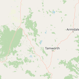
Map view of Gamilaroi Nature Reserve

Use this park location map to pinpoint Gamilaroi Nature Reserve in Australia, understand its exact geographic position, and read its mapped placement within the surrounding landscape more clearly.

Pigeon | © OpenStreetMap contributors

Location context for Gamilaroi Nature Reserve

New South Wales

Visualizing the rare woodland habitats and terrain of New South Wales

Gamilaroi Nature Reserve Photos and Landscape Scenery Visual Guide

Visual records reveal the distinct woodland canopy and quartzite terrain defining Gamilaroi Nature Reserve across its protected area footprint. Detailed photography provides direct insight into the rare plant communities and specialized habitats of this inland New South Wales sanctuary.

A tall Ooline tree with textured bark and green leaves standing in a dry, open woodland habitat with scrubby vegetation.

Park atlas

Compare nearby regional reserves, woodland habitats, and eastern Australian conservation areas.

Exploring Parks Near Gamilaroi Nature Reserve and Surrounding Protected Landscapes

Continue browsing other parks near Gamilaroi Nature Reserve to examine connected woodland ecosystems and regional protected areas. Comparing adjacent reserves reveals broader vegetation patterns and geological transitions across the North West Slopes.
National parkNew South Wales
About 23 km away#1 closest

South

Mount Kaputar National Park: New South Wales Volcanic National Park Atlas

Explore mapped volcanic terrain and ecological diversity.

Mount Kaputar National Park offers a compelling study in protected landscape geology and ecology. Situated in New South Wales, this national park preserves the significant geological features of ancient volcanic remnants, including prominent plugs and lava terraces. Its high-elevation position supports a variety of ecosystems, making it a critical area for understanding inland Australia's natural geography and protected land patterns. Browse its mapped boundaries and discover the unique character of this volcanic wilderness.

Area
502.25 km²
Established
1959
IUCN
II
Relief
Mountain
Watercolor painting of a river flowing between rocky cliffs with forest in the background
National parkNew South Wales
About 103 km away#2 closest

Northeast

Kwiambal National Park: New South Wales National Park with Granite Landscapes and River Confluence

Explore the dramatic scenery of MacIntyre Falls and surrounding protected terrain.

Kwiambal National Park is a significant protected area in New South Wales, Australia, celebrated for its unique granite outcrops and the spectacular confluence of the Severn and Macintyre Rivers at MacIntyre Falls. This national park provides a clear example of regional protected landscape identity, offering valuable context for atlas-driven discovery of Australia's natural geography and mapped terrain. The park's distinctive features contribute to its importance as a conservation reserve within the New England region.

Area
65.17 km²
Established
2000
IUCN
II
Scope
Terrestrial
National parkNew South Wales
About 104 km away#3 closest

Southeast

Warrabah National Park: Discover Protected Landscape and Mapped Geography in New South Wales

Explore the geographic context of this Australian national park.

Warrabah National Park is a designated national park in New South Wales, Australia, offering critical insights into protected area geography. This resource details its mapped boundaries and its place within the region's natural landscape. Understand the park's protected land identity and its contribution to the broader geographical atlas, providing a foundation for focused landscape exploration.

Area
34.71 km²
Established
1984
IUCN
II
Relief
Highland
National parkNew South Wales
About 107 km away#4 closest

East

Indwarra National Park: New South Wales National Park Protected Landscape and Geographic Context

Explore mapped park boundaries and regional geography.

Indwarra National Park is identified as a significant protected area within New South Wales, Australia, offering a unique focus for geographic exploration. As a national park, its mapped boundaries define a distinct natural landscape. This page provides detailed atlas-style information, enabling a deeper understanding of its terrain, regional context, and protected-area significance for structured discovery.

Area
9 km²
Established
1999
IUCN
Ia
Relief
Mountain
National parkNew South Wales
About 113 km away#5 closest

East

Kings Plains National Park: National Park Protected Area and Geographic Context

Explore mapped boundaries and landscape details for this New South Wales park.

Kings Plains National Park represents a distinct protected area entity within New South Wales, Australia. This national park serves as a focal point for understanding specific geographic features and its mapped boundaries. Users engaging with this park profile can uncover its regional landscape context and explore its significance as part of a larger atlas of protected natural areas. The focus remains on its geographic identity and atlas-based discovery value.

Area
57 km²
Established
1988
IUCN
II
Access
Moderate access
National parkNew South Wales
About 122 km away#6 closest

East

Single National Park National Park: A Protected Landscape within New South Wales

Explore mapped boundaries and regional geography.

Single National Park represents a vital protected area, contributing significantly to the natural landscape of New South Wales. This entry offers a deep dive into its geographic scope, detailing mapped park boundaries and the surrounding regional context. It serves as a foundational piece for understanding the park's identity as a protected natural asset and its place within Australia's broader conservation geography.

Area
25.63 km²
Established
1999
IUCN
II
Relief
Mixed relief
National parkAustralia
About 133 km away#7 closest

Northeast

Dthinna Dthinnawan National Park: Australia National Park Protected Landscape Identity

Mapped geography and regional natural terrain.

Delve into Dthinna Dthinnawan National Park, a designated national park in Australia. This page focuses on its role as a protected landscape, detailing its geographic position and mapped features. Understand the park's specific contribution to the Australian atlas of natural terrains and conservation areas, offering structured discovery for those interested in its unique environmental setting.

Established
2005
Relief
Upland
Scope
Terrestrial
Water
No major water
National parkNew South Wales
About 147 km away#8 closest

South

Garrawilla National Park: New South Wales Protected Woodland Ecosystems & Regional Geography

Explore mapped boundaries and native vegetation in this inland Australian national park.

Garrawilla National Park represents a significant protected landscape in New South Wales, Australia, dedicated to conserving semi-arid woodland terrain and characteristic native grass communities. Established to safeguard these vital ecosystems, the park offers insights into the natural heritage of the Central West region's geography. Users can explore its specific geographic footprint and understand its contribution to the preservation of inland Australian vegetation, providing a clear picture of its protected area identity.

Area
9.37 km²
Established
2005
IUCN
II
Scope
Terrestrial

Common questions about visiting, size, designation, and location context for Gamilaroi Nature Reserve

Gamilaroi Nature Reserve FAQs for park facts, access, geography, and protected area context

Find quick answers about Gamilaroi Nature Reserve, including protected-area facts, park geography, trail and visitor context, and how the park fits into its surrounding country and regional landscape.
MoriAtlas Explorer

Continue Your Protected Areas Search Across the Global Atlas

Deepen your exploration by continuing the structured search for national parks and protected areas worldwide. Utilize the comprehensive filtering capabilities to compare different conservation landscapes and refine your understanding of global park geography. Discover more about the distribution and characteristics of protected natural areas.

Global natural geography