
Rivers
Park geography
Analyzing the terrain, coastal features, and environmental landscape of this protected area
Comprehensive Geographic Profile and Mapped Boundaries of Garden Route National Park
This geographic profile details the administrative context and physical characteristics of Garden Route National Park in South Africa. Spanning 1,210 square kilometers, the park encompasses diverse environments including temperate forests, coastal cliffs, riverine systems, and marine habitats. The record includes documented peaks and a wide array of coastal bays situated within the primary boundary.
Related tags
Coastal National ParkIndigenous ForestSouth AfricaFynbos BiomeLake System
Coastal wilderness reserve spanning indigenous forests and dramatic cliffs in South Africa's Western Cape
Garden Route National Park
Garden Route National Park is a expansive coastal protected area located in the Garden Route region of South Africa's Western Cape and Eastern Cape provinces. Established on 6 March 2009 through the amalgamation of several former protected areas including Tsitsikamma National Park, Wilderness National Park, and the Knysna National Lake Area, the park spans approximately 1,210 square kilometers of diverse landscapes. The park is renowned for its remarkable indigenous forests, which form part of the Knysna-Amatole montane forests, and its dramatic coastline characterized by rugged cliffs, pristine beaches, and sheltered bays. This coastal reserve occupies a unique ecological position in Africa as the only area on the continent experiencing year-round rainfall, supporting rich biodiversity and verdant vegetation that distinguishes the Garden Route from other South African wilderness areas.
- Location
- South Africa
- Park type
- National park
- Established
- 2009
- Area
- 1,210 km²
Location overview
Regional placement and coastal marine status within the Cape provinces
Geographic Profile of Garden Route National Park in South Africa
Garden Route National Park is situated in South Africa, spanning the Western Cape and Eastern Cape regions. Integrated coastal and marine classifications define the territorial reach of the protected conservation zone.
- Countries
- South Africa
- Regions
- Eastern Cape, Western Cape
- Primary location
- South Africa
- Geographic setting
- Coastal · Marine
Boundary and coordinates
Spatial footprint and regional extent spanning 1210 square kilometers
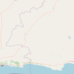
Geographic Boundary Map and Spatial Limits of Garden Route National Park
Mapped boundary outlines trace the spatial footprint of Garden Route National Park along the coast. Verified facts detail the estimated land area, center coordinates, and regional geographic span.
- Boundary area
- 1,664.1 km²
- Boundary perimeter
- 1,215.3 km
- Northernmost point
- 33.7641° S
- Southernmost point
- 34.11° S
- Easternmost point
- 24.1978° E
- Westernmost point
- 22.5124° E
- Geographic centre
- 33.9328° S, 23.4165° E
- North–south span
- 38.4 km
- East–west span
- 155.8 km
Terrain and natural features
Mapped relief classifications and recorded natural landmarks
Garden Route National Park Terrain and Named Natural Features
Mixed relief classifications span the protected territory alongside recorded rivers, peaks, and coastal bays. Linked feature cards supply names, types, and spatial relationships for each mapped landmark.
Selected named natural features
Peaks
Perdekop
931.8 m
Waterfalls
Jerling River
Rivers
Kliprivier
Bays
Jim se Baai
Streams
Jerling River
Environmental setting
Temperate climate zones, forest cover, and diverse habitat types
Garden Route National Park Environmental Setting and Landscape Classifications
Recorded landscape features, habitat types, and relief categories combine to form interpretive classifications of the physical setting. Linked records connect these environmental attributes to relevant atlas destinations across the protected area.
- Relief
- Mixed relief
- Climate
- Temperate
- Water
- Major water bodies
- Forest cover
- Mostly forested
- Seasonality
- Year-round
Landscape features
Forest · Coast · Cliffs · Lakes · Rivers · Woodland · Wetland · Beach · Valleys · Hills
Habitat types
Temperate broadleaf forest · Shrubland · Lacustrine habitat · Riverine habitat · Coastal habitat · Marine habitat
Park atlas
Map the regional protected landscapes and national parks across South Africa's southern coastal geography.
Discover Nearby National Parks and Protected Areas Surrounding Garden Route National Park
Explore a curated selection of national parks and protected areas located near Garden Route National Park, encompassing coastal reserves, indigenous forests, and diverse mountain landscapes. Compare these protected areas to understand regional geography, conservation patterns, and the broader spread of natural heritage across South Africa's Western and Eastern Cape.
National parkSouth Africa
About 0 km away#1 closest
East

Tsitsikamma National Park: South Africa's Protected Coastal Forest and Terrain
Explore the unique mapped landscape and protected area boundaries.
Tsitsikamma National Park in South Africa is defined by its striking coastal geography, where ancient indigenous forests descend towards rugged shores. This national park is a prime example of a protected landscape that showcases the dynamic interface between land and sea, featuring dramatic cliffs and iconic river mouths. Understanding its mapped boundaries and diverse terrain provides critical context for regional geographic exploration and the study of conservation areas within South Africa.
- Established
- 2009
- IUCN
- II
- Relief
- Mixed relief
- Climate
- Mediterranean
National parkSouth Africa
About 0.2 km away#2 closest
Knysna National Lake Area National Park: A Protected Landscape in South Africa
Explore its mapped boundaries and regional natural geography.
Knysna National Lake Area National Park is a key protected area in South Africa, offering a focused lens for understanding national park geography and protected landscapes. This entry provides an atlas-centric perspective on its landscape context, mapped terrain, and its significance as a distinct natural area within the broader South African geography. Explore the structured details of this park's protected boundaries and its contribution to the country's conservation map.
- Access
- Easy access
- Scope
- Mixed
- Water
- Water-dominated
National parkWestern Cape
About 0.2 km away#3 closest
Wilderness National Park: National Park in Western Cape Province, South Africa
Explore mapped protected areas and regional geography.
Wilderness National Park stands as a significant protected area within the Western Cape province of South Africa. This page provides a detailed view of its role as a national park, emphasizing its geographic placement and mapped boundaries. Understand the park's contribution to the region's natural landscape and its significance within the broader atlas of protected lands.
- Area
- 1,210 km²
- Established
- 2009
- Relief
- Lowland
- Access
- Easy access
Wildlife reserveWestern Cape
About 58 km away#4 closest
West
Gondwana Game Reserve: Geographic Overview of a Southern Cape Rewilding Landscape
Protected mountain and coastal savanna terrain in the Western Cape
Gondwana Game Reserve represents a deliberate conservation effort to restore large mammal populations to the southern coast of South Africa. Situated near the Garden Route, the reserve encompasses a complex mosaic of open plains, rolling hills, and mountain vistas, providing essential habitat connectivity for diverse wildlife species within a protected and managed ecosystem.
- Area
- 110 km²
- Relief
- Mountain
- Climate
- Mediterranean
- Access
- Access unknown
Nature reserveWestern Cape
About 61 km away#5 closest
West
Gamkaberg Nature Reserve: An Atlas Overview of Mountain Geography and Protected Biomes
A vital conservation landscape within the Western Cape of South Africa.
Gamkaberg Nature Reserve stands as a focal point for ecological research and conservation in the Little Karoo. Defined by a rugged mountain range and deep gorges, the reserve protects the critical habitat of the Cape mountain zebra. Its landscape reveals an unusual overlap of four Cape biomes, offering a deep look into the regional geography and biological history of the South African interior.
- Area
- 94 km²
- Established
- 1974
- Relief
- Mountain
- Climate
- Mediterranean
Biosphere reserveWestern Cape
About 78 km away#6 closest
West
Gouritz Cluster Biosphere Reserve: Geographic Overview and Protected Area Boundaries
A diverse protected landscape spanning the Western Cape coastline to high mountain ridges.
Spanning from the southern African coast into the interior mountain ranges, this biosphere reserve captures an unmatched variety of landforms including estuaries, rocky headlands, and arid Karoo basins. It serves as a vital protected system for threatened species and endemic flora, representing one of the most ecologically significant landscapes within the Cape Floristic Region.
- Area
- 31,878.9 km²
- Established
- 2015
- Relief
- Mixed relief
- Climate
- Mediterranean
National parkEastern Cape
114 km away#7 closest
East
Addo Elephant National Park: South African National Park with Diverse Protected Landscapes
Explore its geographic context and unique Big Seven megafauna habitats.
Addo Elephant National Park is a crucial protected landscape within South Africa's Eastern Cape, covering approximately 1,640 square kilometers of varied terrain including karoo plains, coastal dunes, and marine protected areas. Its identity is deeply tied to the successful recovery of elephant populations and its distinction as the only African national park where all Big Seven megafauna can be observed in their natural surroundings. Discover the park's geographic spread, landscape diversity, and its role as a premier conservation area.
- Area
- 1,640 km²
- Established
- 1931
- IUCN
- II
- Visitors
- 305.5K annual
Protected areaWestern Cape Province
About 152 km away#8 closest
West
Boosmansbos Wilderness Area: Geographic Atlas and Protected Landscape Overview
Rugged Langeberg mountain terrain and endemic floral corridors
Boosmansbos Wilderness Area stands as a major protected block in the eastern Langeberg range. This profile maps the diverse topography, ranging from rocky mountain ridges to moist valley forests. Learn about the geographic significance of this wilderness, which encompasses rare botanical species and serves as a vital transition zone between fynbos and indigenous forest habitats within the Western Cape.
- Area
- 142 km²
- Relief
- Mountain
- Climate
- Mediterranean
- Access
- Moderate access
MoriAtlas Explorer
Continue Exploring Garden Route National Park's Geographic Details and Protected Terrain
Delve deeper into the atlas of Garden Route National Park to understand its precise geographic scope and the character of its protected landscapes. Examine the mapped boundaries, distinct terrains, and the full spectrum of its natural context within South Africa. This detailed exploration enriches your understanding of the park's unique conservation value and its place on the map of protected areas.
Browse next
Global natural geography
Explore related park routes
Explore MoriAtlas Global ParksBrowse All MoriAtlas ParksGlobal Park Map DiscoveryMoriAtlas: Browse All CountriesBrowse All MoriAtlas ContinentsNational Park Environment AtlasGrand Canyon National Park AtlasYellowstone National Park AtlasYosemite National Park Atlas and GeographySerengeti National Park AtlasGalápagos National Park Protected LandscapeBanff National Park Geography and AtlasKruger National Park Atlas EntryUluṟu-Kata Tjuṯa National Park AtlasExplore Uluru-Kata Tjuta National Park GeographyPlitvice Lakes National Park AtlasFiordland National Park Protected LandscapeGreat Smoky Mountains National Park AtlasAfghanistan National Parks and Protected AreasAlbania National Parks and Protected AreasAlgeria National Parks and Protected AreasAmerican Samoa National Parks and Protected AreasAndorra National Parks and Protected AreasAngola National Parks and Protected AreasAntarctica National Parks and Protected AreasAntigua and Barbuda Park List