Mori Atlas logo
National parkGishwati Forest

Discover the mapped boundaries and regional context of this key national park.

Gishwati Forest National Park: Explore Rwanda's Protected Landscape and Geography

(Gishwati-Mukura National Park)

Gishwati Forest National Park represents a vital protected area within Rwanda's Western Province. This page offers an atlas-driven perspective, detailing the park's geographic setting and its significance as a mapped natural landscape. Understand its place in the broader regional geography and explore its protected boundaries through detailed geographic data.

Eastern AfricaMontane ForestChimpanzee HabitatRestoration SuccessUNESCO Biosphere ReservePrimate Conservation

Gishwati Forest

National park

Park overview

Structured park overview, official facts, and landscape profile for Gishwati Forest

Gishwati Forest park facts, protected area profile, and essential visitor context
Review the core facts for Gishwati Forest, including designation, size, terrain, visitor scale, habitats, and operating context in one park-focused overview.

About Gishwati Forest

Gishwati Forest represents one of Rwanda's most significant conservation areas, situated in the country's Western Province near Lake Kivu. The forest exists today as part of Gishwati-Mukura National Park, established in 2015, which encompasses both the Gishwati and Mukura forest concessions. This protected area occupies roughly 32 square kilometers of highland terrain, with the highest points reaching above 2,400 meters in elevation. The forest sits within a landscape of rolling hills that characterize Rwanda's western highlands, an area that once supported continuous rainforest cover connecting to the Congo basin to the west and extending southward toward Nyungwe Forest. The transformation of this landscape from contiguous rainforest to a fragmented and degraded state, followed by concerted restoration efforts, makes Gishwati a notable case study in ecological recovery. The forest is now managed through a partnership between the Rwanda Development Board, Wilderness Safaris, and the Forest of Hope Association, with tourism operations concentrated in the Gishwati concession while the Mukura section remains closed for visitor activities.

Quick facts and research context for Gishwati Forest

Gishwati Forest occupies roughly 32 square kilometers within Gishwati-Mukura National Park in Rwanda's Western Province. The area sits at elevations exceeding 2,400 meters at its highest points. Originally part of a continuous mid-African rainforest corridor, the forest became severely fragmented through agricultural expansion and human settlement. The region experienced dramatic biodiversity loss, with fauna populations declining by over ninety-nine percent between the late twentieth century and early 2000s. Reforestation efforts since the late 2000s have expanded the remnant native forest from approximately 1,500 acres to around 2,500 acres, earning the area its nickname the Forest of Hope.

Park context

Deeper park guide and search-rich context for Gishwati Forest

Gishwati Forest history, landscape, wildlife, and travel context
Explore Gishwati Forest through its history, landscape character, ecosystems, wildlife, conservation priorities, cultural context, and seasonal travel timing in a structured park guide built for atlas discovery and search intent.

Why Gishwati Forest stands out

Gishwati Forest is best known for its recovering population of Eastern chimpanzees, which have increased from just 13 individuals in 2008 to over 30 by the early 2020s. The forest supports four primate species including the golden monkey, blue monkey, and L'Hoest's monkey, alongside other notable mammals such as the red river hog, African golden cat, and serval. Beyond its primate population, the forest is recognized for its dramatic ecological recovery story, having been designated a UNESCO World Biosphere Reserve in 2020. The area also features notable botanical diversity including giant tree ferns, blue lichen, and numerous indigenous hardwood species.

Gishwati Forest history and protected-area timeline

The history of Gishwati Forest reflects both the ecological richness of Rwanda's highland rainforests and the profound environmental impacts of human displacement and agricultural expansion. In 1930, the forest covered approximately 70,000 acres as part of a continuous rainforest corridor across central Africa. This extensive forest system began fragmenting due to population growth and agricultural conversion over subsequent decades, but substantial forest cover remained intact through the 1970s and into the mid-1980s. The Rwandan genocide of 1994 accelerated the forest's decline as waves of refugees arrived and cleared vegetation for subsistence agriculture. By 2001, only a small circular patch of native forest remained, approximately 1,500 acres representing just six percent of the original forest area. Environmental degradation followed, including severe soil erosion, landslides, reduced water quality, and declining agricultural productivity. The Gishwati Area Conservation Program launched in 2007 through a collaboration between the Rwandan government and international conservation organizations, marking the beginning of systematic restoration efforts. The initiative, dubbed the Forest of Hope, aimed to reverse the forest's decline and eventually establish formal national park status. In 2011, the Forest of Hope Association took over management of the reserve, and in 2015 the forest was officially designated as part of Gishwati-Mukura National Park. By the late 2020s, the forest had increased in size by sixty-seven percent from its minimum extent, and the chimpanzee population had grown substantially.

Gishwati Forest landscape and geographic character

The landscape of Gishwati Forest consists of rolling highland terrain characterized by steep hillsides and deep valleys that define Rwanda's western province topography. The forest sits at elevations ranging from approximately 2,000 meters at lower reaches to over 2,400 meters at the highest points within the reserve. The terrain presents a challenging environment with slopes that contributed to severe erosion during periods of forest loss. The area transitions between different vegetation zones as elevation increases, with lower slopes historically supporting more diverse lowland rainforest species while higher elevations featured montane forest communities. Several perennial streams descend through the catchment areas, their water quality historically affected by upstream deforestation and soil erosion. The surrounding landscape consists largely of agricultural hillside cultivation interspersed with remnant forest patches, creating a mosaic pattern that characterizes much of Rwanda's highland farming areas. Tea estates occupy significant portions of the central and northern sections of the reserve, a land use that predates the formal protected area designation and continues within the park boundaries.

Gishwati Forest ecosystems, habitats, and plant life

The ecological character of Gishwati Forest reflects its position within Rwanda's highland rainforest ecosystem, a biodiversity-rich zone that forms part of the Albertine Rift region. The forest supports recorded tree and shrub species numbering fifty-eight, including numerous indigenous hardwood varieties and bamboo species in certain areas. Studies of the forest's regeneration patterns reveal distinct ecological zones, with undisturbed areas dominated by species such as Macaranga kilimandscharica while previously disturbed zones show colonization by species including Carapa grandiflora, Entandrophragma excelsum, and Symphonia globulifera. The forest also features notable lower plant communities including giant tree ferns and distinctive blue lichen species. The ecosystem provides important watershed functions for downstream communities, with the forest's root systems helping to stabilize soils on steep slopes and maintain water catchment quality. The elevation gradient within the reserve creates habitat diversity that supports both lowland and montane species assemblages, though the fragmented nature of the current forest limits the ecological continuity that once characterized the broader region.

Gishwati Forest wildlife and species highlights

Gishwati Forest supports a notable primate community despite its reduced size, with four species confirmed to inhabit the reserve. The Eastern chimpanzee population represents the flagship species, with estimates indicating approximately thirty individuals in the forest as of the early 2020s, a significant increase from the thirteen individuals recorded in 2008 when systematic conservation efforts began. The population includes several infants, suggesting successful reproduction in the recovering forest. Other primates include the golden monkey, blue monkey, and L'Hoest's monkey, the latter also known as the mountain monkey. The mammal community extends beyond primates to include species such as the red river hog, black-fronted duiker, southern tree hyrax, serval, and African golden cat. The forest hosts eighty-four bird species, including the white-headed wood hoopoe and mountain yellow warbler, both considered near-endemic to the region. Reptile diversity includes the great lakes bush viper and multiple chameleon species, while amphibian populations include the brown forest frog and various toad species. The overall fauna represents a remarkable recovery considering the near-complete collapse of the ecosystem in the early 2000s.

Gishwati Forest conservation status and protection priorities

Gishwati Forest has become a focal point for conservation innovation in Rwanda and the broader Great Lakes region, serving as both a biodiversity refuge and a testing ground for restoration approaches. The designation of Gishwati-Mukura National Park as a UNESCO World Biosphere Reserve in 2020 acknowledged the area's significance for both ecological conservation and sustainable development. The chimpanzee population, once reduced to just thirteen individuals, has become a symbol of successful intervention, with the population increasing by over fifty percent through combined anti-poaching efforts, habitat protection, and community engagement. The conservation model integrates tourism as a funding mechanism, with chimpanzee tracking permits generating revenue that supports both protection activities and local community benefits. A ten-thousand-acre corridor project aims to eventually reconnect Gishwati Forest with Nyungwe National Park approximately thirty miles to the south, enabling genetic exchange between chimpanzee populations and restoring migration corridors for other species. The reforestation program has planted over ten thousand indigenous tree seedlings in recent years, with ongoing efforts to expand native forest cover while managing the competing land uses that characterize the surrounding landscape.

Gishwati Forest cultural meaning and human context

The Gishwati Forest area is home to communities whose livelihoods are intimately connected to the forest landscape, though this relationship has been complicated by decades of environmental change and displacement. The forest historically provided local populations with wild fruits, vegetables, and medicinal plants, resources that have declined dramatically alongside forest cover loss. The area experienced significant population displacement during the Rwandan genocide, with refugees arriving in the forest and establishing agricultural settlements that contributed to rapid deforestation. The conservation initiatives that followed have sought to balance ecological restoration with community needs, with programs employing local residents as guides, trackers, and conservation staff. The Forest of Hope Association, the local organization managing conservation activities, represents an attempt to build community ownership of the restoration process. The landscape also reflects Rwanda's broader relationship with reforestation and environmental restoration, as the country has pursued aggressive greening initiatives that include the creation of national parks and community woodlots across the highlands.

Top sights and standout views in Gishwati Forest

The recovering chimpanzee population remains the primary draw for visitors to Gishwati Forest, offering opportunities to observe these primates in their highland habitat despite the challenges posed by limited habituation compared to other Rwanda chimpanzee tracking destinations. The forest's elevation provides a distinct highland experience, with the Matyazo hill trail ascending to the park's highest point at nearly 2,500 meters offering panoramic views across the canopy. The three established trails—the eight-kilometer Umushwati Trail through the forest interior, the seven-kilometer Waterfall Trail from the guest house area, and the shorter Matyazo hill climb—provide varied options for different fitness levels and interest areas. The Forest of Hope Guest House, the only accommodation option within the park, offers a base for multi-day exploration and early morning chimpanzee tracking excursions. The restoration narrative itself constitutes a highlight for visitors interested in conservation success stories, with the forest's recovery representing one of the most dramatic ecological turnarounds in East Africa.

Best time to visit Gishwati Forest

The optimal period for visiting Gishwati Forest coincides with Rwanda's dry seasons, typically from June through September and again from December through February, when trail conditions are most favorable and wildlife viewing opportunities are enhanced by reduced vegetation density. The higher elevations of the forest can experience cool and misty conditions regardless of season, so layered clothing is advisable year-round. The early morning hours provide the best chances for chimpanzee tracking, as the primates are most active during the cooler parts of the day. The forest's recovery means that visitor facilities are relatively new, with the park having opened to tourism in December 2020, so the experience may evolve as infrastructure and services mature. The timing of visits should be coordinated in advance to secure permits and accommodation at the Forest of Hope Guest House, which operates as the mandatory base for all park visitors.

Park location guide

Geography guide, regional context, and park location map for Gishwati Forest

Gishwati Forest park geography, regions, and map view in Rwanda
Understand where Gishwati Forest sits in Rwanda through a broader geographic reading of the surrounding landscape, nearby location context, and its mapped position within the national park landscape.

How Gishwati Forest fits into Rwanda

Rwanda is a landlocked East African nation bordered by Uganda, Tanzania, Burundi, and the Democratic Republic of the Congo. The country features mountains in the west, savanna in the southeast, and several volcanoes in the northwest forming part of the Virunga chain. It has a tropical highland climate with two rainy and two dry seasons annually.

Wider geography shaping Gishwati Forest in Rwanda

Rwanda lies in the Great Rift Valley of East Africa, bordered by Uganda to the north, Tanzania to the east, Burundi to the south, and the Democratic Republic of the Congo to the west. The western region features mountains and lakes, while the southeast consists of savanna. Several volcanoes forming part of the Virunga Mountains are located in the northwest.

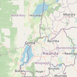
Map view of Gishwati Forest

Use this park location map to pinpoint Gishwati Forest in Rwanda, understand its exact geographic position, and read its mapped placement within the surrounding landscape more clearly.

Pigeon | © OpenStreetMap contributors

Location context for Gishwati Forest

Western Province
Park atlas

Extend your park atlas exploration, comparing Gishwati Forest with other protected areas across Rwanda's diverse regional geography.

Discover Other Protected Areas Near Gishwati Forest and Explore Rwanda's Highland Conservation Landscapes
Broaden your exploration beyond Gishwati Forest, tracing the spread of national parks and vital protected areas across Rwanda's western highlands and the Albertine Rift. Understand the regional context and conservation efforts by comparing park geography, diverse montane forests, and unique primate habitats across these important East African protected landscapes.
National parkRwanda

Volcanoes National Park: Rwanda's Protected Volcanic Landscape and Regional Geography

Mapped park boundaries and East African geographic context.

Delve into Volcanoes National Park, a crucial protected area within Rwanda's northwest. This page offers detailed insight into its geography, highlighting the volcanic terrain and mapped boundaries that define this important national park. Understand its placement within the Virunga Mountains and its contribution to the natural landscape of East Africa, providing a foundation for atlas-based exploration of protected lands.

Area
160 km²
Established
1925
IUCN
II
Relief
Mountain
Watercolor illustration of rolling hills, mountains, and a river or lake
National parkDemocratic Republic of the Congo

Virunga National Park: Democratic Republic of the Congo's Premier Protected Landscape

Mapped boundaries and diverse Albertine Rift endemic geography.

Virunga National Park represents a pivotal protected area within the Democratic Republic of the Congo, characterized by an exceptional range of geographic features and vital ecosystems. Its protected landscape includes active volcanoes like Nyiragongo with its lava lake, the towering Rwenzori Mountains, and diverse lowland savannas. This atlas-focused entry highlights the park's unique position in the Albertine Rift, crucial for numerous endemic species and offering significant insight into regional geography and protected land context.

Area
7,800 km²
Established
1925
IUCN
II
Relief
Mountain
National parkSouth Kivu Province

Kahuzi-Biéga National Park: A Protected Landscape in South Kivu Province's Albertine Rift

Explore its mapped boundaries and diverse terrain.

Kahuzi-Biéga National Park, a significant national park in South Kivu Province, is defined by its dramatic geographic diversity. Spanning approximately 6,000 square kilometers, it features a unique ecological gradient from dense lowland equatorial rainforest in the west to the subalpine zones of the Mitumba Mountains in the east, dominated by the dormant volcanoes Mount Kahuzi and Mount Biéga. This protected landscape offers a rich atlas context for understanding the biodiversity and regional geography of the Albertine Rift, showcasing a vital transition in terrain and habitat.

Area
6,000 km²
Established
1970
IUCN
II
Relief
Mixed relief
National parkBurundi

Kibira National Park: Burundi's Protected National Park Landscape and Geography

Mapped protected area within the Great Rift Valley region.

Kibira National Park represents a vital protected national park entity within Burundi's diverse geography. As part of the Great Rift Valley's expanse, its mapped boundaries and landscape identity offer a focal point for understanding regional protected areas. This park's presence in Burundi contributes essential data to a structured atlas of natural landscapes and conservation lands across East Africa.

Area
400 km²
IUCN
II
Relief
Mountain
Climate
Tropical
National parkKagera Region

Ibanda-Kyerwa National Park: Tanzania's Tri-Border Protected Landscape and Geographic Atlas

Savanna, riparian habitats, and vital regional geography exploration.

Delve into Ibanda-Kyerwa National Park, a recently established national park in Tanzania's Kagera Region. This protected area is distinguished by its critical location at the tri-border with Uganda and Rwanda, with the Kagera River system defining its unique savanna and riparian landscapes. Understanding its mapped boundaries and ecological context provides essential insight into protected land discovery in northwestern Tanzania and its role within the wider regional atlas.

Area
200 km²
Established
2019
IUCN
II
Relief
Highland
National parkEastern Province

Akagera National Park National Park: Protected Landscape Geography and Atlas Exploration

Understand the mapped terrain and regional context of Akagera National Park.

Akagera National Park, designated as a national park, represents a vital protected landscape within Rwanda's Eastern Province. This atlas-focused entry provides essential geographic context, highlighting the park's mapped boundaries and natural terrain. Explore Akagera National Park as a key element in regional geography and a focal point for understanding protected land distribution.

Area
1,122 km²
Established
1934
Visitors
34K annual
Relief
Mixed relief
National parkKagera Region

Rumanyika-Karagwe National Park: Protected Landscape and Geographic Context in Kagera Region

Explore the mapped boundaries and regional setting of this national park.

Rumanyika-Karagwe National Park serves as a vital protected landscape within the Kagera Region of Tanzania. This entry facilitates a geographic discovery of the park, highlighting its mapped outlines and its role as a national park. Users can gain an understanding of its regional landscape context, providing a solid foundation for atlas-based exploration and appreciating the park's protected area status.

Area
247 km²
Established
2019
IUCN
II
Climate
Tropical
National parkBurundi

Rusizi National Park: National Park in Burundi's Geographic Landscape Context

Explore mapped protected area boundaries and regional geography.

Rusizi National Park stands as a significant protected area within Burundi, contributing to the nation's conservation atlas. This national park offers a distinct geographic profile, showcasing its specific landscape and terrain features within the East African context. Users can delve into the mapped boundaries of Rusizi National Park to understand its protected status and its role in the regional geography, facilitating detailed geographic discovery.

Area
90 km²
Established
1980
IUCN
II
Climate
Tropical

Common questions about visiting, size, designation, and location context for Gishwati Forest

Gishwati Forest FAQs for park facts, access, geography, and protected area context
Find quick answers about Gishwati Forest, including protected-area facts, park geography, trail and visitor context, and how the park fits into its surrounding country and regional landscape.
MoriAtlas Explorer

Continue Your Protected Areas Search Across the Global Atlas

Deepen your exploration by continuing the structured search for national parks and protected areas worldwide. Utilize the comprehensive filtering capabilities to compare different conservation landscapes and refine your understanding of global park geography. Discover more about the distribution and characteristics of protected natural areas.

Global natural geography