Mori Atlas logo
National parkGöreme Historical National Park

Discover the unique geography and protected cave dwellings of this Cappadocian national park.

Göreme Historical National Park: Explore Volcanic Landscapes and Rock-Cut Churches in Turkey

Göreme Historical National Park offers a profound journey into a landscape shaped by volcanic forces and human ingenuity. Situated in Turkey's Cappadocia region, this protected area is defined by its extraordinary fairy chimneys and an intricate network of rock-cut churches and monastic settlements. MoriAtlas provides a structured view of this unique national park, detailing its distinct geological formations, the historical significance of its cave dwellings, and its place within the surrounding regional geography. Explore the mapped boundaries and landscape context of a site where natural terrain and ancient habitation merge.

Volcanic LandscapeRock-cut ChurchesByzantine HeritageCappadociaUNESCO World Heritage SiteCave Dwellings

Göreme Historical National Park

National park

Park overview

Structured park overview, official facts, and landscape profile for Göreme Historical National Park

Göreme Historical National Park park facts, protected area profile, and essential visitor context
Review the core facts for Göreme Historical National Park, including designation, size, terrain, visitor scale, habitats, and operating context in one park-focused overview.

About Göreme Historical National Park

Göreme Historical National Park protects one of Turkey's most culturally and geologically significant landscapes. The park is situated in the heart of Cappadocia, a region shaped by volcanic activity millions of years ago. The region's distinctive landscape was formed from soft volcanic tuff that has been carved by wind and water into the fairy chimneys and cave systems that define the area today. Human habitation in this region dates back millennia, with evidence of Hittite and later Roman presence. However, the most visually dramatic cultural layer comes from the Byzantine period, when monks carved extensive monastic communities directly into the rock formations. These cave complexes included churches, refectories, dormitories, and support spaces, creating an entire underground city dedicated to religious life. The park's carved churches contain some of the finest examples of Byzantine wall painting in the region, with scenes depicting Christ, saints, and biblical narratives rendered in vivid colors that remain remarkably preserved. The landscape itself creates a dramatic setting, with valleys and peaks offering views that have inspired visitors for centuries.

Quick facts and research context for Göreme Historical National Park

Göreme Historical National Park is located in Nevşehir Province within Turkey's central Anatolia region. The park protects a portion of the broader Cappadocia volcanic landscape characterized by its iconic fairy chimney rock formations and extensive cave systems. The area was established as a national park to preserve both the remarkable geological formations and the cultural heritage embedded within them, including rock-cut churches and monastic complexes dating to the Byzantine era. The region is situated on a high plateau at elevations between 1,000 and 1,300 meters above sea level.

Park context

Deeper park guide and search-rich context for Göreme Historical National Park

Göreme Historical National Park history, landscape, wildlife, and travel context
Explore Göreme Historical National Park through its history, landscape character, ecosystems, wildlife, conservation priorities, cultural context, and seasonal travel timing in a structured park guide built for atlas discovery and search intent.

Why Göreme Historical National Park stands out

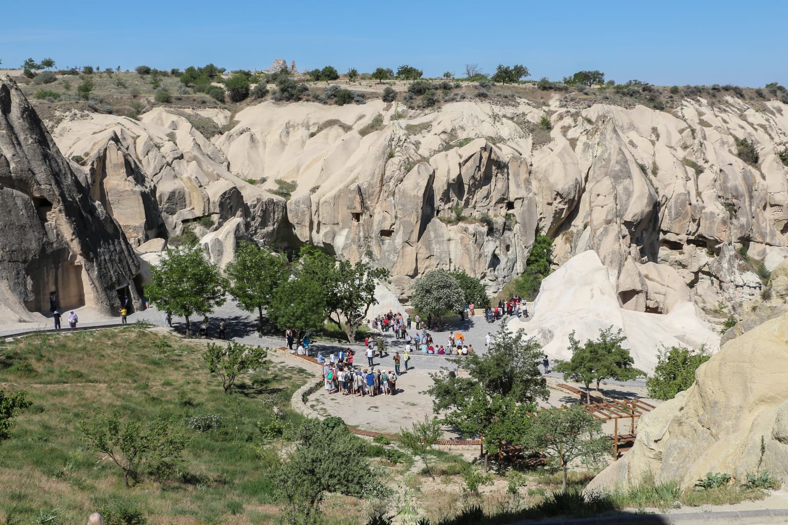
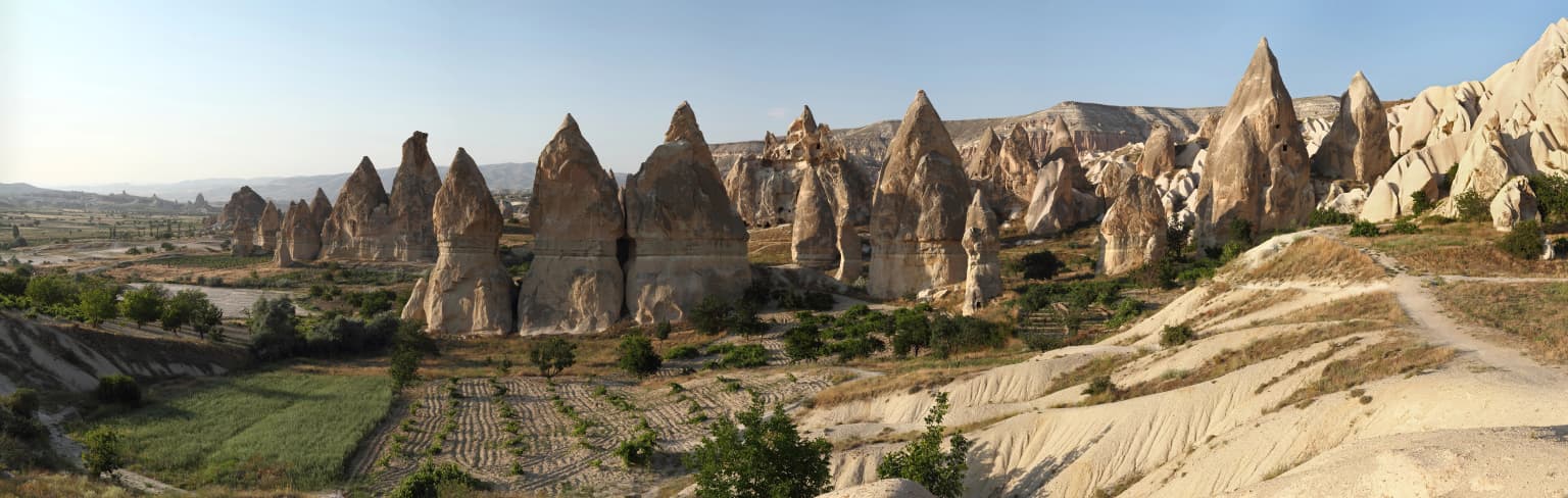
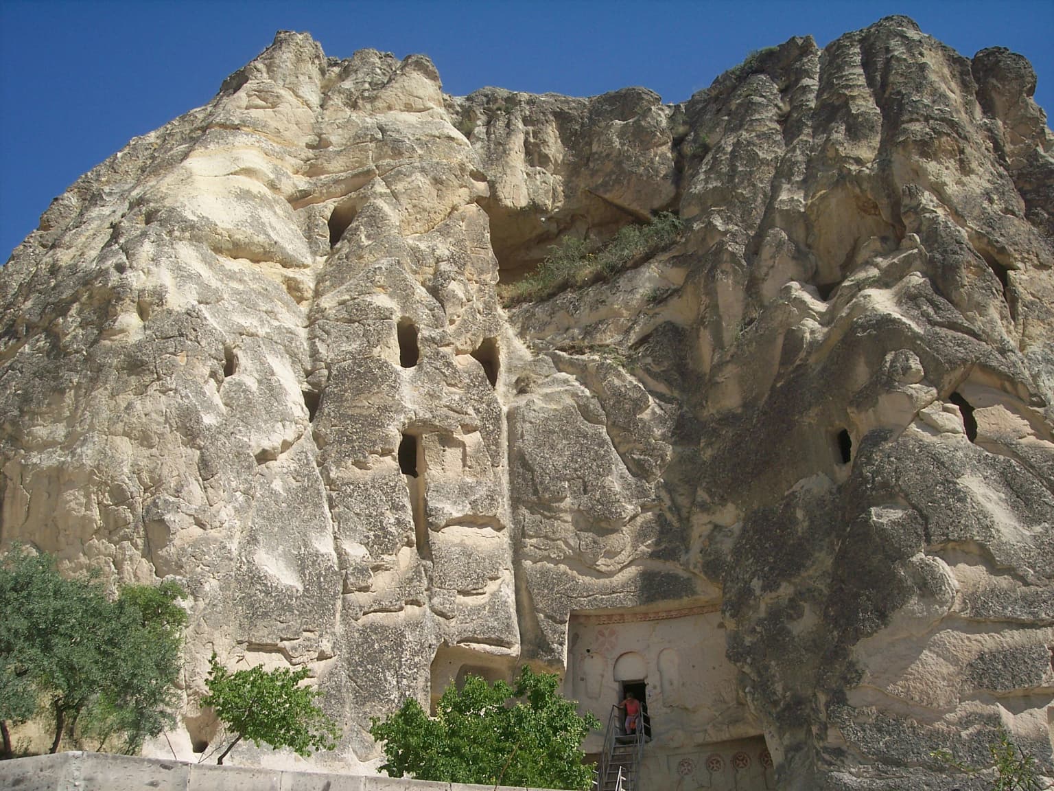
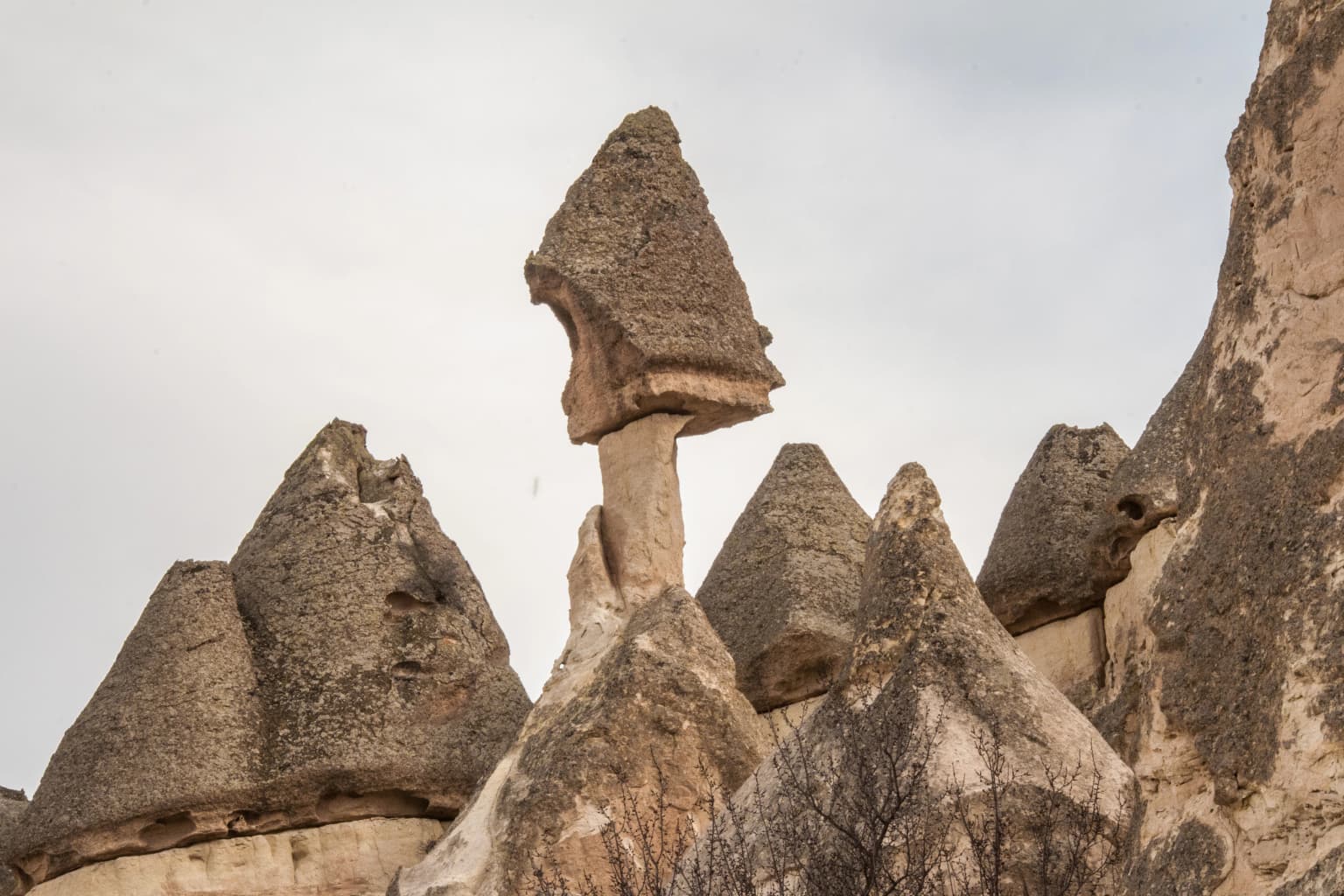
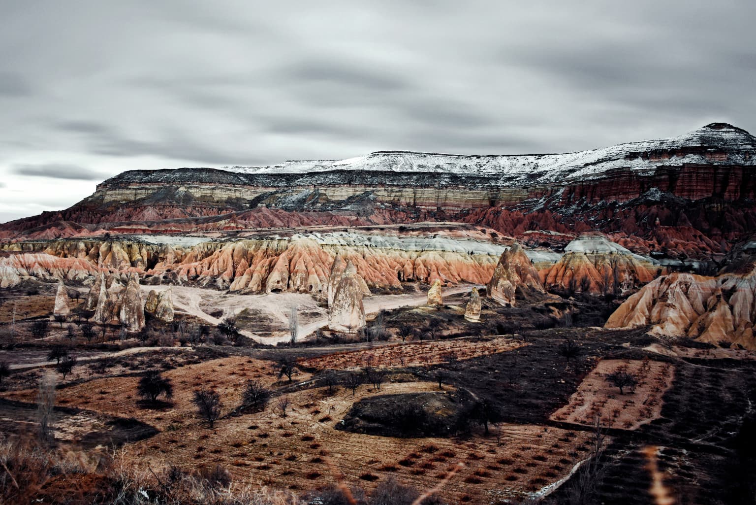
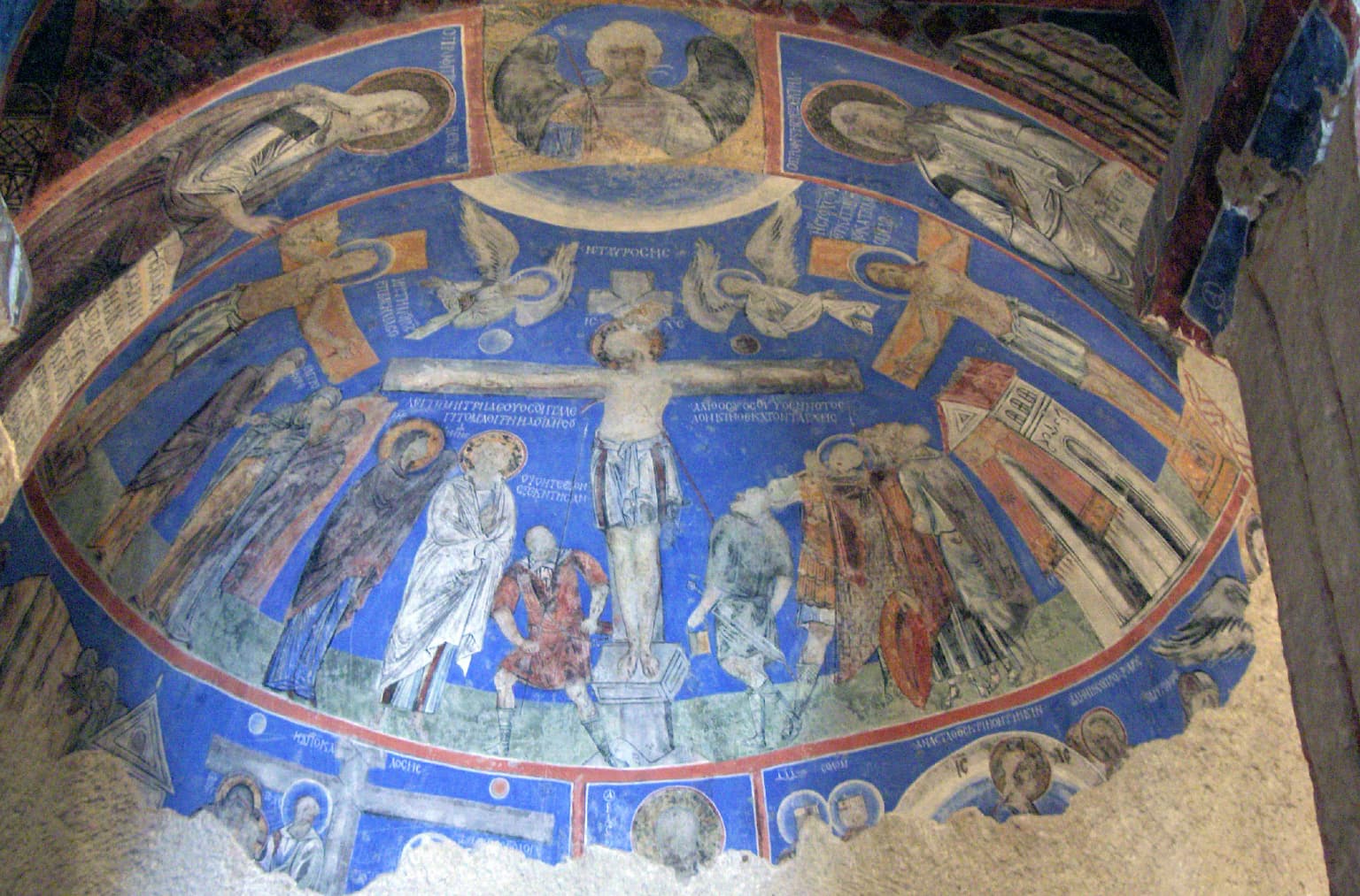
Göreme Historical National Park is best known for its extraordinary fairy chimney formations, tall, cone-shaped rock spires created by differential erosion of volcanic tuff, and the extensive network of rock-cut churches, chapels, and monastic dwellings carved into the soft stone. The park contains one of the largest concentrations of Byzantine cave churches in the world, with interiors featuring well-preserved frescoes dating from the 9th to 11th centuries. The monastic complex of the Open Air Museum represents the artistic and spiritual peak of this cave-dwelling tradition.

Göreme Historical National Park history and protected-area timeline

The protection of Göreme's cultural and natural landscape began in the mid-20th century as awareness grew about the area's unique significance. The area was designated as a national park to ensure the preservation of both the geological formations and the cultural heritage contained within the rock-cut structures. The monastic communities that created the cave churches flourished during the 9th through 11th centuries, a period when Byzantine art and religious practice reached sophisticated heights in this region. After this peak, the communities gradually declined, though the structures remained largely intact due to the protective nature of the cave environment. Modern preservation efforts have focused on stabilizing fragile frescoes, managing visitor impact, and maintaining the structural integrity of the ancient cave complexes.

Göreme Historical National Park landscape and geographic character

The landscape of Göreme Historical National Park is defined by its dramatic volcanic geology. The underlying rock is a soft tuff formed from volcanic ash deposits that solidified into relatively easy-to-carve stone. Over millions of years, erosion shaped this tuff into the iconic fairy chimneys—tall, often mushroom-shaped columns topped with harder caprocks that protect the softer underlying stone. The park encompasses several valleys and peaks, with the terrain rising from approximately 1,000 meters to around 1,300 meters above sea level. Valleys such as the Rose Valley and the Pigeon Valley cut through the landscape, offering opportunities to walk among the rock formations and access cave church entrances. The overall effect is one of a surreal, almost lunar landscape where the distinction between natural formation and human modification blurs.

Göreme Historical National Park ecosystems, habitats, and plant life

The nature of Göreme is intimately tied to its volcanic geological foundation. The vegetation of the park and surrounding Cappadocia region is adapted to the semi-arid continental climate and the rocky terrain. Steppe vegetation dominates the higher areas, with grasses and drought-resistant shrubs prevailing. In the valley bottoms and areas where moisture collects, deciduous trees and shrubs appear, providing seasonal color changes. The park's setting at the edge of the Anatolian steppe creates a transition zone between different ecological communities. The fairy chimneys themselves create unique microhabitats, with different erosion patterns producing varying moisture and temperature conditions that support specialized plant communities.

Göreme Historical National Park wildlife and species highlights

The wildlife in Göreme Historical National Park reflects the semi-natural steppe environment of central Anatolia. Birdlife includes species adapted to the rocky terrain and open landscapes, such as various raptors that nest on cliff ledges and use the thermal updrafts created by the heated valley floors. The cave systems provide roosting sites for bats, which navigate the dark passages using echolocation. Small mammals including rodents and hedgehogs inhabit the rocky areas and steppe margins. The park's location along major migratory routes means that seasonal bird migrations pass over the area, with different species observable during spring and autumn passages.

Göreme Historical National Park conservation status and protection priorities

Göreme Historical National Park represents a dual conservation challenge: protecting geological formations that are slowly being eroded by natural forces while simultaneously preserving the fragile cave churches and their interior frescoes. The park was established to manage these competing needs, balancing visitor access with the long-term survival of the cultural and natural heritage. Conservation work includes monitoring the condition of frescoes, managing visitor numbers in sensitive areas, and conducting stabilization work on vulnerable rock formations. The broader Cappadocia region, including the Göreme area, was inscribed as a UNESCO World Heritage Site, recognizing its outstanding universal value as a cultural landscape.

Göreme Historical National Park cultural meaning and human context

The cultural context of Göreme is deeply rooted in the Christian monastic tradition of the Byzantine period. The cave churches and monastic complexes were not merely functional spaces but represented a spiritual vision where the faithful carved their places of worship directly into the landscape, literally embedding their faith into the geology of the region. The rock-cut churches served communities of monks who lived in associated cave dwellings, creating self-contained monastic complexes. The frescoes within these churches represent sophisticated artistic achievements, with techniques and styles that evolved over the centuries of use. The local communities that developed around these monastic centers maintained connections to the broader Byzantine world while also developing distinctive local characteristics.

Top sights and standout views in Göreme Historical National Park

The extraordinary concentration of rock-cut Byzantine churches within a relatively compact area makes Göreme one of the world's most important early Christian heritage sites. The fairy chimney landscape creates a visual experience unlike anywhere else on Earth, with the natural erosion forms providing a dramatic backdrop to the cultural sites. The Open Air Museum contains the most elaborate and best-preserved cave church complex, with its frescoed interiors offering direct connection to Byzantine artistic traditions. The experience of walking through the valleys, discovering hidden chapels, and moving between rock formations creates a sense of discovery that distinguishes this park from more conventional natural areas.

Best time to visit Göreme Historical National Park

The best time to visit Göreme Historical National Park is during the spring months of April through May and the autumn months of September through October, when temperatures are moderate and the landscape is at its most colorful. Summer months can be quite hot, with temperatures frequently exceeding 30°C, making extensive walking more challenging. Winter brings cold temperatures and occasional snow, but the empty sites and dramatic contrast between snow and the red rock create a unique atmosphere. The shoulder seasons offer the most comfortable conditions for exploring the valleys and churches while avoiding the peak tourist crowds that concentrate in the summer months.

Park location guide

Geography guide, regional context, and park location map for Göreme Historical National Park

Göreme Historical National Park park geography, regions, and map view in Turkey
Understand where Göreme Historical National Park sits in Turkey through a broader geographic reading of the surrounding landscape, nearby location context, and its mapped position within the national park landscape.

How Göreme Historical National Park fits into Turkey

Turkey, officially the Republic of Türkiye, is a transcontinental country located mainly in Anatolia (West Asia) with a smaller portion in East Thrace (Southeast Europe). It borders the Black Sea to the north, several countries to the east and south, and the Aegean Sea and European countries to the west. The country has a population of over 86 million and operates as a secular, Muslim-majority presidential republic with Ankara as capital and Istanbul as its largest city.

Wider geography shaping Göreme Historical National Park in Turkey

Turkey is a transcontinental country with the majority of its territory (about 97%) located in Anatolia (West Asia) and a smaller portion called East Thrace in Southeast Europe. It borders the Black Sea to the north, Georgia, Armenia, Azerbaijan, and Iran to the east, Iraq and Syria to the south, and the Mediterranean Sea to the southwest. To the west, Turkey borders the Aegean Sea, Greece, and Bulgaria. The terrain includes mountains, plateaus, and coastal plains, with the Taurus Mountains running along the southern coast.

Map view of Göreme Historical National Park

Use this park location map to pinpoint Göreme Historical National Park in Turkey, understand its exact geographic position, and read its mapped placement within the surrounding landscape more clearly.

Pigeon | © OpenStreetMap contributors
Park atlas

Browse the protected landscape geography of Cappadocia and central Turkey for more regional park insights.

Discover Related National Parks and Protected Areas Near Göreme Historical National Park
Continue exploring Turkey's protected areas by discovering national parks and natural reserves near Göreme Historical National Park, tracing similar volcanic formations and historical sites across the Cappadocia region. Explore diverse protected landscapes and cultural heritage zones, gaining broader geographic context for atlas-style park comparison in central Turkey.
Watercolor illustration of a wetland landscape with distant mountains, grassy vegetation, and calm water.
National parkKayseri Province

Sultan Reedy National Park: A Vital Protected Wetland Ecosystem in Kayseri Province, Turkey

Mapped landscape focused on ornithological significance and lake ecosystems.

Sultan Reedy National Park stands as a cornerstone of wetland conservation in Turkey, located within the geographically distinct Kayseri Province. This national park is celebrated for its expansive freshwater lakes and dense reed marshes, forming a critical habitat for a vast diversity of bird species. Its Ramsar designation underscores its international importance as a stopover point for migratory birds traversing major flyways, offering a unique window into a dynamic aquatic ecosystem bordered by dramatic mountain terrain.

Area
243.57 km²
Established
2006
Relief
Lowland
Scope
Terrestrial
National parkTurkey

Aladağlar National Park: Turkey's Dramatic Alpine Protected Landscape

Rugged terrain and crimson peaks in the Anti-Taurus Mountains.

Delve into Aladağlar National Park, a significant protected area defined by its striking alpine environment within Turkey's Anti-Taurus range. This park is renowned for its rugged, high-altitude wilderness, characterized by dramatic granite peaks that display a unique crimson coloration, especially at sunset. Its landscape features steep valleys, alpine lakes formed from snowmelt, and challenging mountaineering opportunities. MoriAtlas offers detailed map context to appreciate the geographic distinctiveness and ecological importance of this elevated protected terrain.

Area
550.65 km²
Established
1995
Relief
Mountain
Climate
Alpine
National parkYozgat Province

Yozgat Pine Grove National Park: Historic First National Park and Ancient Pine Forest

Explore the protected landscape of Turkey's original national park.

As Turkey's pioneering national park, Yozgat Pine Grove National Park offers a deep dive into a unique protected landscape. This site provides detailed geographic context for its ancient pine forest, set dramatically against the steppe terrain of Yozgat Province. Understand the park's mapped boundaries and its ecological significance as a historic conservation area. MoriAtlas facilitates a structured exploration of this important natural heritage site, highlighting its role in Turkish protected land history and its distinct regional geography.

Area
2.64 km²
Established
1958
IUCN
II
Relief
Highland
Watercolor illustration showing mountains, a reservoir, and green landscape
National parkOsmaniye Province

Karatepe-Aslantaş National Park: A National Park Bridging Ancient History and Natural Geography

Discover its protected landscape and mapped terrain in Osmaniye Province.

Karatepe-Aslantaş National Park stands as Turkey's second national park and its inaugural open-air museum, situated in Osmaniye Province. This protected area is renowned for its significant Neo-Hittite archaeological remnants, including iconic lion statues and the vital Karatepe Bilingual inscription. The park's landscape is characterized by slightly rugged terrain, woodlands, and maquis scrubland, all set against the backdrop of the Aslantaş Dam reservoir, providing a unique geographic context for exploring ancient heritage and natural ecosystems.

Area
41.45 km²
Established
1958
Relief
Lowland
Climate
Mediterranean
Watercolor illustration of a forested landscape with green trees, rolling hills, and distant mountains
National parkTurkey

Soğuksu National Park: Turkey's Highland Forest Protected Landscape Discovery

Explore mapped boundaries and unique Anatolian geography.

Soğuksu National Park serves as a significant protected natural area in central Turkey, celebrated for its substantial coniferous forest ecosystem. This park showcases a transition zone between major geographic regions, offering a unique highland landscape shaped by volcanic geology. Discover its mapped protected boundaries and its role as a vital natural atlas point within the broader Turkish geography, featuring diverse terrain and important ecological elements.

Area
11.87 km²
Established
1959
National parkKastamonu Province

Mount Ilgaz National Park: A Protected Landscape at the Crossroads of Anatolian Geography

Explore unique ecosystems and mapped terrain in Kastamonu Province

Mount Ilgaz National Park offers a deep dive into a unique protected landscape where Central Anatolian and Black Sea ecosystems converge. Situated in Kastamonu Province, its rugged mountain terrain and distinct mapped boundaries showcase a rich geographic identity. This park is an essential point for understanding Turkey's biogeographic transition zones, its diverse forest ecosystems, and the regional context of the Ilgaz Mountains. Delve into its protected status and discover the interplay of climate and terrain that defines this significant natural area.

Area
7.424 km²
Established
1976
IUCN
II
Relief
Mountain
Watercolor painting of colorful rowboats on a lake with distant mountains
National parkKonya Province

Lake Beyşehir National Park: Protected Landscape Geography and Mapped Boundaries

Discover the geography and mapped context of this national park in Konya.

Lake Beyşehir National Park is a major protected area in Turkey's Central Anatolia region, celebrated for its immense freshwater lake and diverse wetland habitats. The park's identity is strongly tied to its mapped boundaries that protect critical ecosystems, islands, and surrounding forested terrain. This page provides a detailed look at the park's geographic setting within Konya Province, serving as a valuable resource for atlas-based discovery of its unique natural and cultural landscape.

Area
868.55 km²
Established
1993
Relief
Lowland
Climate
Temperate
Watercolor illustration of green hills, pine trees, and distant mountains under a light sky
National parkIsparta Province

Kızıldağ National Park: Protected Taurus Mountain Landscape and Atlas Context

Mapped boundaries, alpine terrain, and unique cedar forests.

Kızıldağ National Park offers a detailed look into Turkey's protected natural heritage, specifically highlighting the dramatic mountainous terrain of the Taurus Ranges. This page provides atlas-level geographic information about its mapped boundaries, the significant Dedegöl Mountain, and the rare blue-leaf cedar forests unique to this region. Understand its role as a vital conservation area within Isparta Province and the broader Mediterranean mountain ecosystem.

Area
551.06 km²
Established
1969
Relief
Mountain
Scope
Terrestrial

Common questions about visiting, size, designation, and location context for Göreme Historical National Park

Göreme Historical National Park FAQs for park facts, access, geography, and protected area context
Find quick answers about Göreme Historical National Park, including protected-area facts, park geography, trail and visitor context, and how the park fits into its surrounding country and regional landscape.
MoriAtlas Explorer

Continue Your Protected Areas Search Across the Global Atlas

Deepen your exploration by continuing the structured search for national parks and protected areas worldwide. Utilize the comprehensive filtering capabilities to compare different conservation landscapes and refine your understanding of global park geography. Discover more about the distribution and characteristics of protected natural areas.

Global natural geography