Mori Atlas logo
National parkSoğuksu National Park

Discover the mapped boundaries and unique ecosystems of this Anatolian national park.

Soğuksu National Park: A Highland Forest Protected Area in Turkey's Transitional Geography

(Soğuksu Millî Parkı)

Soğuksu National Park represents a critical protected landscape situated in central Turkey, marking a significant transition between the Black Sea's forested regions and the Anatolian steppe. This national park, covering 1,187 hectares, features rugged volcanic terrain with elevations reaching up to 1,800 meters, fostering a rare and substantial coniferous forest ecosystem. Explore the park's mapped boundaries and understand its unique geographic context within Turkey's diverse natural atlas.

National ParkForest Protected AreaConiferous ForestBirdwatchingVolcanic LandscapeCentral Anatolia
Stylized illustration of a mountainous landscape with evergreen trees, rolling hills, and a setting sun under a pastel sky

Soğuksu National Park

National park

Park overview

Structured park overview, official facts, and landscape profile for Soğuksu National Park

Soğuksu National Park park facts, protected area profile, and essential visitor context
Review the core facts for Soğuksu National Park, including designation, size, terrain, visitor scale, habitats, and operating context in one park-focused overview.

About Soğuksu National Park

Soğuksu National Park occupies a distinctive position in Turkey's protected area network as one of the oldest national parks, established in 1959 to preserve a significant forest ecosystem in central Anatolia. The park's location in the Kızılcahamam district places it in a geographically and ecologically transitional area where the humid, forested conditions of the Black Sea region meet the drier, more continental climate of the interior highlands. This positioning has produced a landscape of considerable variety—dense forests of Scots pine, larch, and fir cover the hillsides, while streams drain through small valleys that converge into two main watercourses. The terrain is rugged, with elevation differences creating diverse microhabitats throughout the park. Beyond its ecological value, the park serves as an important recreational outlet for Ankara's population, offering hiking trails, camping facilities, and thermal spa amenities within a relatively short distance from the capital. The 16-kilometer trail system provides access to viewpoints and natural features, while visitor infrastructure including an information center, restaurants, and a 300-bed thermal spa accommodates those seeking longer stays. Only one-third of the park area is designated for public use, with the remainder maintained as protected natural area to preserve the forest ecosystem and its wildlife.

Quick facts and research context for Soğuksu National Park

Soğuksu National Park spans 1,187 hectares in Ankara Province, making it one of Turkey's older protected areas established in 1959. The park sits at a mean elevation of approximately 1,100 meters in a transition zone between the Black Sea and Central Anatolia climate regimes. Its 933 hectares of forest represent European-Siberian vegetation, with Scots pine comprising 65% of tree cover. The park hosts about 160 bird species and serves as habitat for near-threatened species including the cinereous vulture. Volcanic geology underlies the area, with andesite, basalt, and tuff formations, and petrified wood deposits approximately 10-12 million years old exist in the northern section. The park lies 2 kilometers west of Kızılcahamam town and is managed by Turkey's Ministry of Forest and Water Management.

Park context

Deeper park guide and search-rich context for Soğuksu National Park

Soğuksu National Park history, landscape, wildlife, and travel context
Explore Soğuksu National Park through its history, landscape character, ecosystems, wildlife, conservation priorities, cultural context, and seasonal travel timing in a structured park guide built for atlas discovery and search intent.

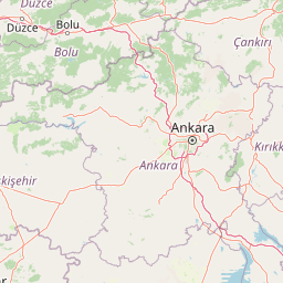
Why Soğuksu National Park stands out

Soğuksu National Park is best known for its significant forest ecosystem in the heart of Anatolia, a region where dense woodland becomes increasingly rare as one moves southward into the central steppe. The park's mix of coniferous forest, rolling hills, and volcanic terrain creates a distinctive highland landscape. It is particularly notable for its population of cinereous vultures and other raptors that nest in the area, making it a destination for birdwatching. The presence of petrified wood fossils in the northern sector represents a unique geological feature, while the park's historical connection to Mustafa Kemal Atatürk, who rested beneath a pine tree in the area in 1934, adds cultural significance. The proximity to Ankara makes this one of the most accessible nature destinations for residents of the capital.

Panoramic view of forested mountains with pine trees under clear blue sky
Forested mountain landscape in Soğuksu National Park, Turkey

Soğuksu National Park history and protected-area timeline

Soğuksu National Park was established on February 19, 1959, making it one of Turkey's earliest national parks created under the country's post-war conservation framework. The initial protected area covered 1,050 hectares before being extended in 1979 to its current size of 1,187 hectares. The park was established to protect the significant forest ecosystem in this part of central Anatolia, where woodland is otherwise limited due to the region's continental climate and steppe conditions. The area has historical significance beyond its ecological value—the site known as Atatürk's Pine Tree marks where Mustafa Kemal Atatürk rested under a pine tree during a visit to the area in July 1934. This location remains a point of cultural heritage within the park, with an annual Atatürk Day commemorated at the site on July 18 each year. The Ministry of Forest and Water Management has administered the park since its establishment, developing visitor facilities and recreational infrastructure over the decades while maintaining protection of the core natural areas.

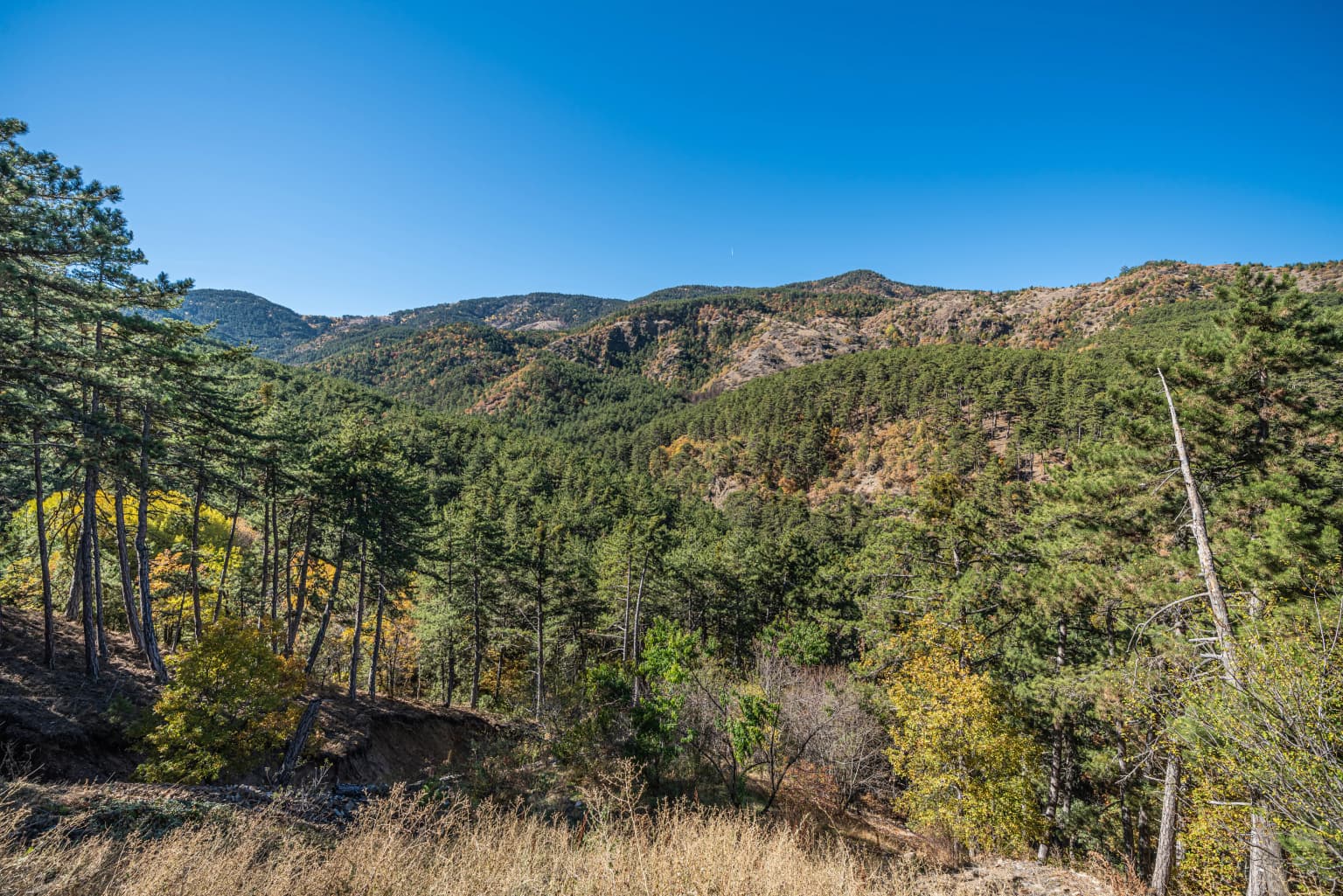
Soğuksu National Park landscape and geographic character

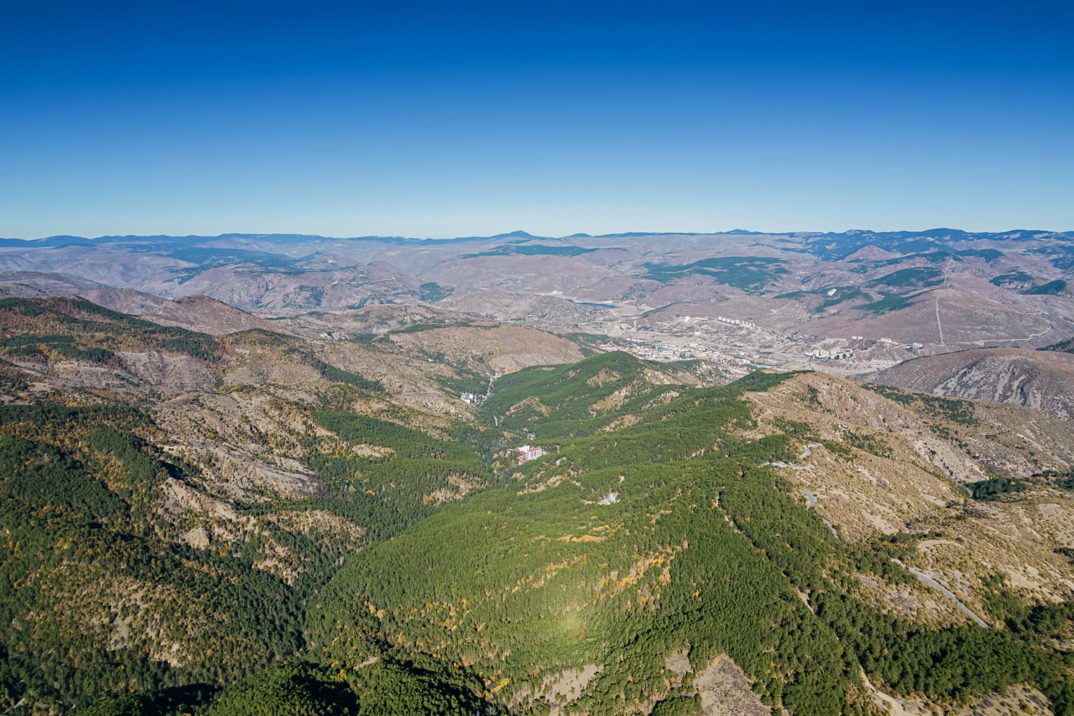
The landscape of Soğuksu National Park is defined by its volcanic origin and position in a transition zone between two major geographical regions of Turkey. The terrain is rugged and hilly, with elevations ranging from 1,030 meters in the valley floors to 1,800 meters at the highest peaks. The most prominent summits are Arhut Hill at 1,789 meters and Tolubelen Hill at 1,776 meters, while other notable elevations include Harmandoruk Hill, Çakmaklı's Doruktepe, Samrıdoruk Hill, Kayabelen Hill, Kel Hill, and Kara Hill. The park consists of plains interspersed between small valleys that drain into two main valley systems fed by seasonal streams—Batılganın Creek and Küçük Soğuksu Creek, both of which dry during the summer months. The underlying geology consists of volcanic rocks including andesite, basalt, tuff, and agglomerate, with hot springs and cold water sources emerging in various locations. In the northern part of the park, deposits of petrified wood dating to approximately 10-12 million years ago represent a remarkable geological feature, with one preserved trunk measuring 250 centimeters in length and 170 centimeters in diameter.

Panoramic landscape of Soğuksu National Park showing dense forest in the foreground, rolling hills in the midground, and a partly cloudy sky
Panoramic view of Soğuksu National Park with forested hills under a partly cloudy sky

Soğuksu National Park ecosystems, habitats, and plant life

The forest ecosystem of Soğuksu National Park represents one of the most significant woodland areas in central Anatolia, characterized by European-Siberian vegetation types in an otherwise predominantly steppe region. The forests cover 933 hectares of the park's total area and are dominated by coniferous species—Scots pine accounts for approximately 65% of the tree cover, followed by larch at 24% and fir at 6%. Broadleaf species including oak, alder, aspen, maple, dogwood, and black locust contribute to the forest's diversity, collectively representing about 5% of the tree population. The understory and low vegetation include wild strawberry, wild rose, wild pear, dwarf juniper, wild hazelnut, and hawthorn, creating a layered habitat structure. This forest composition creates important ecological functions in the transition zone between the Black Sea region's humid forests and the continental interior, providing habitat for species adapted to both moist and drier conditions. The park's elevation range and varied topography further enhance habitat diversity across the protected area.

Aerial view of rolling mountains and forested valleys in Soğuksu National Park under a clear blue sky
Aerial view of Soğuksu National Park's mountainous landscape and forested valleys

Soğuksu National Park wildlife and species highlights

Soğuksu National Park supports a rich avifauna of approximately 160 bird species, making it an important area for bird conservation in central Anatolia. The park is particularly significant for populations of near-threatened bird species, including the cinereous vulture (Aegypius monachus) and several eagle species that nest within the park boundaries. A dedicated birdwatching station was established in 2009 at the hillside of Kayabelen Hill to observe black vultures, with an associated feeding station located at Yanık Sırtı. The woodlands also support populations of larger mammals including red deer and roe deer, while species such as bear, wolf, fox, jackal, weasel, wild boar, rabbit, and squirrel are present in smaller numbers. The park maintains a bird hatchery operation that breeds chukar partridge, grey partridge, falcon, pheasant, quail, and pigeon species, contributing to conservation and potentially restocking efforts. This combination of forest-dwelling mammals, raptors, and breeding bird populations creates a relatively diverse wildlife community for a protected area in central Anatolia.

Large archway entrance sign for Soğuksu National Park, blue informational sign, vehicles on paved road, forested hills and trees in background
Entrance archway of Soğuksu National Park with blue signage and forested hills in the background

Soğuksu National Park conservation status and protection priorities

Soğuksu National Park represents an important conservation outcome in central Anatolia, protecting a forest ecosystem that would otherwise be vulnerable to logging, agricultural conversion, or degradation in this transition zone between climatically distinct regions. The park's establishment in 1959 reflected early recognition of the ecological value of this woodland area at a time when Turkey was developing its national park system. The forest ecosystem, representing European-Siberian vegetation, supports species that have limited habitat elsewhere in the region, while the presence of near-threatened bird species like the cinereous vulture adds international conservation significance. The park's management strategy divides the area, with only one-third designated for public recreation and the remaining two-thirds maintained as protected natural area to preserve core ecological functions. The volcanic geology and petrified wood deposits also represent geological heritage worth protection, while the hot springs and associated thermal waters contribute to the park's environmental diversity.

Soğuksu National Park cultural meaning and human context

The cultural significance of Soğuksu National Park extends beyond its natural features to include historical connections to Turkey's founding leader. The site known as Atatürk's Pine Tree marks where Mustafa Kemal Atatürk rested beneath a pine tree during a visit to the Kızılcahamam area in July 1934. This location has been preserved as a point of heritage within the park, and an annual Atatürk Day is held on July 18 to commemorate the historical visit. The surrounding region of Kızılcahamam has been known for its hot springs and thermal waters, which have attracted visitors for centuries and contributed to the area's reputation as a spa destination. The park sits within a landscape of small villages including Karacaören, Sazak, Saraycık, and Alveren, representing the rural communities that have historically interacted with this forested highland area.

A wide landscape view showing snow-covered mountains, brown-leafed trees in the foreground, and rolling hills extending into the distance under a cloudy sky
Panoramic view of Soğuksu National Park's mountainous terrain with snow-capped peaks under an overcast sky

Top sights and standout views in Soğuksu National Park

Soğuksu National Park offers a rare combination of accessible forest wilderness near Turkey's capital. The coniferous forests covering the hillsides represent a significant woodland ecosystem in central Anatolia where such coverage is uncommon. Birdwatching opportunities focus on the cinereous vulture and other raptor species that nest in the area, supported by dedicated observation facilities. The volcanic geology provides distinctive landscape character and petrified wood deposits approximately 10-12 million years old. Historical significance attaches to Atatürk's Pine Tree, where the republic's founder once rested in 1934. The 16-kilometer trail network, thermal spa facilities, and camping areas provide recreational infrastructure while only one-third of the park is developed, preserving the natural core.

Best time to visit Soğuksu National Park

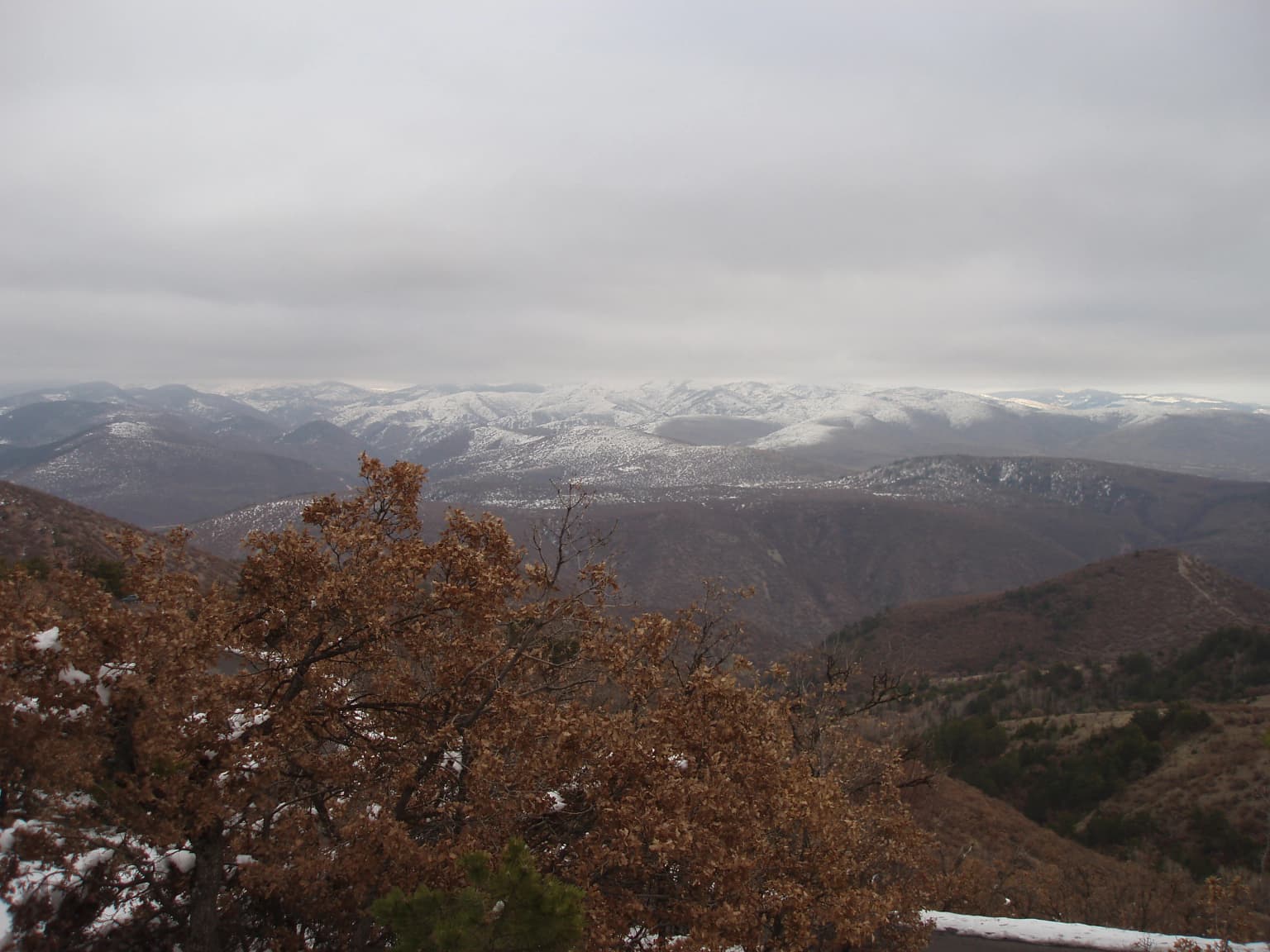
The best time to visit Soğuksu National Park depends on the experience sought, but the summer months offer the most reliable access to trails and outdoor activities when the park's facilities are fully operational. The park's high elevation means temperatures are noticeably cooler than in Ankara or the surrounding lowlands, providing a welcome retreat during hot summer periods. Spring and autumn offer different character—the forests display seasonal color changes and the quieter conditions may suit those seeking more contemplative visits. Winter brings snow to the higher elevations and a dramatically different landscape, though some facilities may have reduced services. The transition climate between the Black Sea and Central Anatolia regions means weather patterns can vary, and visitors should be prepared for conditions that may differ from the nearby steppe or coastal areas.

Park location guide

Geography guide, regional context, and park location map for Soğuksu National Park

Soğuksu National Park park geography, regions, and map view in Turkey
Understand where Soğuksu National Park sits in Turkey through a broader geographic reading of the surrounding landscape, nearby location context, and its mapped position within the national park landscape.

How Soğuksu National Park fits into Turkey

Turkey, officially the Republic of Türkiye, is a transcontinental country located mainly in Anatolia (West Asia) with a smaller portion in East Thrace (Southeast Europe). It borders the Black Sea to the north, several countries to the east and south, and the Aegean Sea and European countries to the west. The country has a population of over 86 million and operates as a secular, Muslim-majority presidential republic with Ankara as capital and Istanbul as its largest city.

Wider geography shaping Soğuksu National Park in Turkey

Turkey is a transcontinental country with the majority of its territory (about 97%) located in Anatolia (West Asia) and a smaller portion called East Thrace in Southeast Europe. It borders the Black Sea to the north, Georgia, Armenia, Azerbaijan, and Iran to the east, Iraq and Syria to the south, and the Mediterranean Sea to the southwest. To the west, Turkey borders the Aegean Sea, Greece, and Bulgaria. The terrain includes mountains, plateaus, and coastal plains, with the Taurus Mountains running along the southern coast.

Map view of Soğuksu National Park

Use this park location map to pinpoint Soğuksu National Park in Turkey, understand its exact geographic position, and read its mapped placement within the surrounding landscape more clearly.

Pigeon | © OpenStreetMap contributors

Location context for Soğuksu National Park

Ankara Province

An image gallery showcasing the diverse natural scenery and protected habitats of Soğuksu National Park in Central Anatolia.

Soğuksu National Park Photos: Explore Volcanic Terrain, Coniferous Forests, and Protected Habitats
View comprehensive imagery of Soğuksu National Park, revealing its distinctive volcanic landscapes, dense coniferous forests, and diverse ecological zones within Central Anatolia. These visuals offer critical insight into the park's highland terrain, raptor habitats, and the unique transitional environment that defines this significant protected area in Turkey.

Panoramic view of forested mountains with pine trees under clear blue sky

Aerial view of forested mountains and valleys under a clear blue sky

Panoramic landscape of Soğuksu National Park showing dense forest in the foreground, rolling hills in the midground, and a partly cloudy sky

Aerial view of rolling mountains and forested valleys in Soğuksu National Park under a clear blue sky

Large archway entrance sign for Soğuksu National Park, blue informational sign, vehicles on paved road, forested hills and trees in background

Rolling hills and forested valleys under a partly cloudy sky in Soğuksu National Park

A wide landscape view showing snow-covered mountains, brown-leafed trees in the foreground, and rolling hills extending into the distance under a cloudy sky

Park atlas

Trace the geographic spread of protected landscapes, comparing their diverse central Anatolian forest and volcanic features with Soğuksu National Park.

Continue Your Park Discovery: Explore Other National Parks Near Soğuksu National Park
Discover other national parks and protected areas surrounding Soğuksu National Park, allowing you to compare conservation landscapes across central Turkey's varied geographic regions. This atlas view illuminates regional ecosystem patterns, from unique coniferous forests to volcanic terrains, helping users identify diverse protected natural areas for continued exploration.
Watercolor painting showing multiple lakes surrounded by green trees and mountains under a light sky
National parkBolu Province

Yedigöller National Park: Bolu Province's Landslide Lake and Forested Protected Landscape

Discover mapped terrain and unique natural park geography.

Yedigöller National Park presents a distinctive protected landscape within Bolu Province, notable for its chain of seven landslide-formed lakes and extensive, dense forests. This page serves as your entry point to understanding the park's geographic distribution, mapped boundaries, and the characteristic terrain that defines this important natural area. Explore the unique ecosystem and its place within the broader regional geography through structured atlas-style discovery.

Area
16.23 km²
Established
1965
IUCN
II
Relief
Mixed relief
Watercolor painting of a lake surrounded by green hills and trees with colorful foliage
National parkBolu Province

Lake Abant National Park: Protected Volcanic Crater Lake & Alpine Landscape

Bolu Province, Turkey | National Park | Mapped Landscape

Lake Abant National Park is a protected national park renowned for its stunning volcanic crater lake and surrounding alpine forests within Bolu Province. This detailed entry provides insight into the park's geographic context, its unique volcanic terrain, and its status as a protected landscape. Explore the mapped boundaries and understand the ecological significance of this distinctive natural area in northwestern Turkey.

Area
11.965 km²
Established
2022
Relief
Mountain
Climate
Temperate
National parkAnkara Province

Mount Sarıçalı National Park: Turkey's Newest Protected Mountain Landscape

Ancient forests, endemic botany, and dramatic mountain terrain.

Mount Sarıçalı National Park, located in Ankara Province, Turkey, is a testament to the nation's commitment to conservation. This protected area is celebrated for its ancient forests, with larch, Kasnak oak, and juniper trees dating back 700-800 years. Its position at the confluence of three phytogeographic zones supports a rich array of 139 endemic plant species. The park's landscape is further characterized by the striking Uyuzsuyu Waterfall and the imposing Mount Sarıçalı peak, offering a profound geographic context for atlas exploration.

Area
10.24 km²
Established
2021
Relief
Mountain
Scope
Terrestrial
National parkKastamonu Province

Mount Ilgaz National Park: A Protected Landscape at the Crossroads of Anatolian Geography

Explore unique ecosystems and mapped terrain in Kastamonu Province

Mount Ilgaz National Park offers a deep dive into a unique protected landscape where Central Anatolian and Black Sea ecosystems converge. Situated in Kastamonu Province, its rugged mountain terrain and distinct mapped boundaries showcase a rich geographic identity. This park is an essential point for understanding Turkey's biogeographic transition zones, its diverse forest ecosystems, and the regional context of the Ilgaz Mountains. Delve into its protected status and discover the interplay of climate and terrain that defines this significant natural area.

Area
7.424 km²
Established
1976
IUCN
II
Relief
Mountain
Watercolor illustration depicting mountain ranges, green forests, and a valley with a body of water
National parkKastamonu Province

Küre Mountains National Park: Ancient Forests and Karst Canyons in Kastamonu Province

Explore Protected Landscape, Map Boundaries, and Regional Geography

Küre Mountains National Park, situated in Kastamonu Province, Turkey, offers a unique glimpse into ancient forest ecosystems and dramatic karst formations. As a protected national park, it is distinguished by its extensive canyon systems, including Horma and Valla, and significant cave networks like Ilgarini Cave. This entry provides detailed geographic context, helping users understand the park's terrain, protected boundaries, and its ecological importance within the Black Sea Region's natural landscape.

Area
377.53 km²
Established
2000
Relief
Mountain
Climate
Temperate
National parkYozgat Province

Yozgat Pine Grove National Park: Historic First National Park and Ancient Pine Forest

Explore the protected landscape of Turkey's original national park.

As Turkey's pioneering national park, Yozgat Pine Grove National Park offers a deep dive into a unique protected landscape. This site provides detailed geographic context for its ancient pine forest, set dramatically against the steppe terrain of Yozgat Province. Understand the park's mapped boundaries and its ecological significance as a historic conservation area. MoriAtlas facilitates a structured exploration of this important natural heritage site, highlighting its role in Turkish protected land history and its distinct regional geography.

Area
2.64 km²
Established
1958
IUCN
II
Relief
Highland
Protected areaTurkey

Commander-in-Chief National Historic Park: Historic Battlefield Landscape in Turkey

Protected Area preserving pivotal geography and military history.

Commander-in-Chief National Historic Park is a designated protected area in Turkey, preserving the historic terrain of the decisive Battle of Dumlupınar. This site offers a unique glimpse into the geography and landscape that were instrumental in a key moment of the Turkish War of Independence. Explore the mapped context of this significant battlefield, understanding its role within the broader Anatolian geography and its importance as a preserved historic site.

Area
409.48 km²
Established
1981
Relief
Mixed relief
Climate
Temperate
National parkTurkey

Göreme Historical National Park: A Mapped Volcanic Landscape and Protected Cultural Heritage in Turkey

Explore the unique geography and rock-cut churches of Cappadocia.

Göreme Historical National Park presents a globally significant protected landscape, celebrated for its dramatic volcanic geology and extensive rock-cut architecture. This national park in Turkey's Cappadocia region features iconic fairy chimneys and ancient cave dwellings, offering a rich context for exploring human adaptation to natural terrain. MoriAtlas facilitates a detailed discovery of its mapped boundaries and regional geography, highlighting the intersection of natural wonder and historical habitation within this unique protected area.

Common questions about visiting, size, designation, and location context for Soğuksu National Park

Soğuksu National Park FAQs for park facts, access, geography, and protected area context
Find quick answers about Soğuksu National Park, including protected-area facts, park geography, trail and visitor context, and how the park fits into its surrounding country and regional landscape.
MoriAtlas Explorer

Continue Your Protected Areas Search Across the Global Atlas

Deepen your exploration by continuing the structured search for national parks and protected areas worldwide. Utilize the comprehensive filtering capabilities to compare different conservation landscapes and refine your understanding of global park geography. Discover more about the distribution and characteristics of protected natural areas.

Global natural geography