

Mori Atlas logo
State or regional parkGumbaynggirr State Conservation Area

Mapping the volcanic basalt plateau and unlogged forest remnants on the New South Wales Mid North Coast

Gumbaynggirr State Conservation Area: A Protected Subtropical Rainforest Atlas and Map

Gumbaynggirr State Conservation Area represents a vital protected enclave of subtropical rainforest within the Mid North Coast region of New South Wales. This atlas entry details the mapped boundaries of the League Scrub and Little Wonder forest tracts, highlighting the geological significance of the underlying basalt plateau and the dense, tall canopy structure that characterizes this unique volcanic terrain. Through precise geographic analysis, the platform provides insights into the park's isolated forest composition and its historical evolution as a community-secured conservation reserve.

subtropical rainforesteast coast rainforestMid North CoastNew South Walesleague scrubbasalt plateau

Gumbaynggirr State Conservation Area

State or regional park

Park overview

Structured park overview, official facts, and landscape profile for Gumbaynggirr State Conservation Area

Gumbaynggirr State Conservation Area park facts, protected area profile, and essential visitor context

Review the core facts for Gumbaynggirr State Conservation Area, including designation, size, terrain, visitor scale, habitats, and operating context in one park-focused overview.

About Gumbaynggirr State Conservation Area

Gumbaynggirr State Conservation Area sits in the forested hinterland behind the Mid North Coast of New South Wales, well west of the better known coastal strip around Nambucca Heads. Although it lies only a short distance from the coast in geographic terms, the reserve feels like a different world: a cool, moist, elevated landscape of basaltic ridges and tall subtropical jungle, rather than the beach and estuary environments for which the region is widely known.

The conservation area brings together two complementary protected areas. The first and most celebrated is the League Scrub, a compact tract of subtropical rainforest that has escaped commercial harvesting and retained an unusually complete forest structure. The second is land that was once managed as the Little Wonder State Forest, the subject of a sustained community blockade in 1992 that ultimately led to logging being halted and the forest being folded into the reserve system. Together they form a connected refuge for rainforest flora in a region where much of the original forest was historically cleared or milled.

The reserve sits on a basalt bench of unusually fertile red soil, with volcanic history evident from scattered pumice across the rainforest floor. Elevation of around 750 metres above sea level, combined with high rainfall, creates conditions that support a tall, layered, and species rich rainforest. The canopy climbs to roughly 40 metres, enveloping a varied midstorey and understorey of ferns, vines, palms, and groundcover plants characteristic of east coast subtropical jungle.

Ecologically, the conservation area matters because it preserves rainforest taxa and structural diversity that have become rare elsewhere on the Mid North Coast. Socially and culturally, it matters because its name recognises the Gumbaynggirr people, the Traditional Owners of the broader landscape, and because the protection of the Little Wonder section is remembered locally as an important environmental campaign. Managed by the NSW National Parks and Wildlife Service, the reserve functions as both an ecological archive and a tangible legacy of community forest advocacy.

Quick facts and research context for Gumbaynggirr State Conservation Area

Gumbaynggirr State Conservation Area is a New South Wales state conservation area located in the Mid North Coast region, west of Nambucca Heads. Established in its current protected form on 1 July 2003, it covers about 25.6 square kilometres of forest and rainforest, including the celebrated League Scrub and a former state forest section once known as Little Wonder. The reserve sits at roughly 750 metres elevation on a basaltic bench with red volcanic soils and high rainfall, supporting a tall, unlogged subtropical rainforest canopy. Administration is handled by the NSW National Parks and Wildlife Service.

Protection and recognition

Review documented terrestrial protection scope and official recognition details.

Gumbaynggirr State Conservation Area Protection Status and Mapped Geography

Gumbaynggirr State Conservation Area maintains a defined terrestrial protection scope within its regional conservation framework. Official records compile documented management parameters, designation history, and international recognition data for the protected area.

Protection details

Protection scope
Terrestrial
Transboundary protection
No
Park context

Deeper park guide and search-rich context for Gumbaynggirr State Conservation Area

Gumbaynggirr State Conservation Area history, landscape, wildlife, and travel context

Explore Gumbaynggirr State Conservation Area through its history, landscape character, ecosystems, wildlife, conservation priorities, cultural context, and seasonal travel timing in a structured park guide built for atlas discovery and search intent.

Why Gumbaynggirr State Conservation Area stands out

The park is best known for the League Scrub, an isolated patch of subtropical rainforest that has never been logged and still contains an unusually tall, diverse canopy. It is also recognised for protecting the formerly contested Little Wonder forest, a stand of rainforest that became a focus of community driven anti logging activism before being secured as part of the conservation area. Beyond these headline features, the reserve draws attention for its volcanic substrate, indicated by pumice fragments on the forest floor, and for the rich mix of tree species packed into a relatively small area, including stinging trees, yellow carabeen, Moreton Bay fig, and several native cherries and maples.
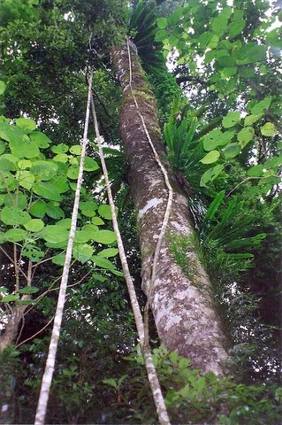
A low-angle view looking up a tall, thick tree trunk in a dense subtropical rainforest, with multiple long, thin vines trailing down the trunk and surrounding foliage including broad leaves and ferns.
Subtropical rainforest canopy and large tree trunk with epiphytic ferns and climbing vines at League Scrub.

Gumbaynggirr State Conservation Area history and protected-area timeline

The two main forested sections that make up the present conservation area have very different histories. The League Scrub has long been recognised for its undisturbed rainforest character and was protected from commercial logging, allowing the original tall canopy and species mix to survive in essentially intact form.

The adjoining section, formerly known as Little Wonder State Forest, was the focus of a much more contested history. In 1992, locals opposed to logging established a year long blockade to prevent harvesting in the forest. The persistence of the protest halted logging operations in the area and created the political and community momentum that eventually led to the forest being brought into the protected area network.

On 1 July 2003, these lands were consolidated into a single state conservation area under the management of the NSW National Parks and Wildlife Service. The combined reserve continues to be valued both as a living example of unlogged subtropical rainforest and as a reminder of how community driven action can permanently change land management outcomes on the New South Wales coast.

Gumbaynggirr State Conservation Area landscape and geographic character

The landscape of the conservation area is shaped by a basaltic plateau or bench that rises to around 750 metres above sea level. Red, relatively fertile soils derived from the underlying basalt support the dense rainforest vegetation, while pumice fragments scattered across the forest floor reveal the area's volcanic geological past.

The result is an elevated, wet, sheltered environment quite distinct from the coastal lowlands nearby. Rainfall is high, and moisture is retained beneath the dense canopy, creating conditions that favour the tall, layered rainforest structure typical of east coast subtropical Australia. Slopes, ridges, and small drainage lines break up the terrain, and the forest closes in overhead so that sunlight reaches the forest floor in scattered shafts.

Although small in total area, the reserve concentrates landscape variety within a compact footprint. Visitors moving between the better known League Scrub and the adjoining former state forest experience a continuous sense of enclosed, elevated rainforest terrain, with little of the surrounding coastal or pastoral landscape visible from within the forest itself.
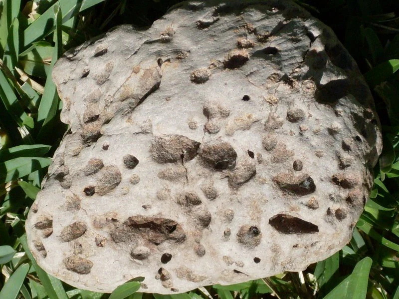
A close-up view of a porous, light-colored pumice stone sitting on green grass or forest floor vegetation.
A piece of porous pumice rock resting on the rainforest floor in Gumbaynggirr State Conservation Area.

Gumbaynggirr State Conservation Area ecosystems, habitats, and plant life

Gumbaynggirr State Conservation Area is dominated by subtropical rainforest of a kind that was once more widespread on the New South Wales Mid North Coast. The vegetation is layered in classic rainforest fashion, with a high canopy of emergent trees, a dense midstorey of smaller trees, palms, and tree ferns, and a low understorey rich in vines, ferns, and groundcover plants.

The rainforest here is unusually biodiverse for its size, with about 73 tree species recorded across the reserve. This diversity gives the forest its characteristically complex texture, where a single small patch can contain figs, carabeens, cherries, stinging trees, and hardwoods growing side by side. Species such as yellow carabeen, Moreton Bay fig, small leaf fig, black booyong, bonewood, purple cherry, sour cherry, and rose maple all contribute to the canopy and subcanopy layers.

The volcanic substrate plays a quiet but important role in this ecology. The basalt derived red soils are relatively fertile, and combined with high rainfall and sheltered topography they support the kind of vigorous forest growth that produces a 40 metre canopy. Pumice fragments across the ground reflect the deeper geological history that originally built much of the surrounding landscape.
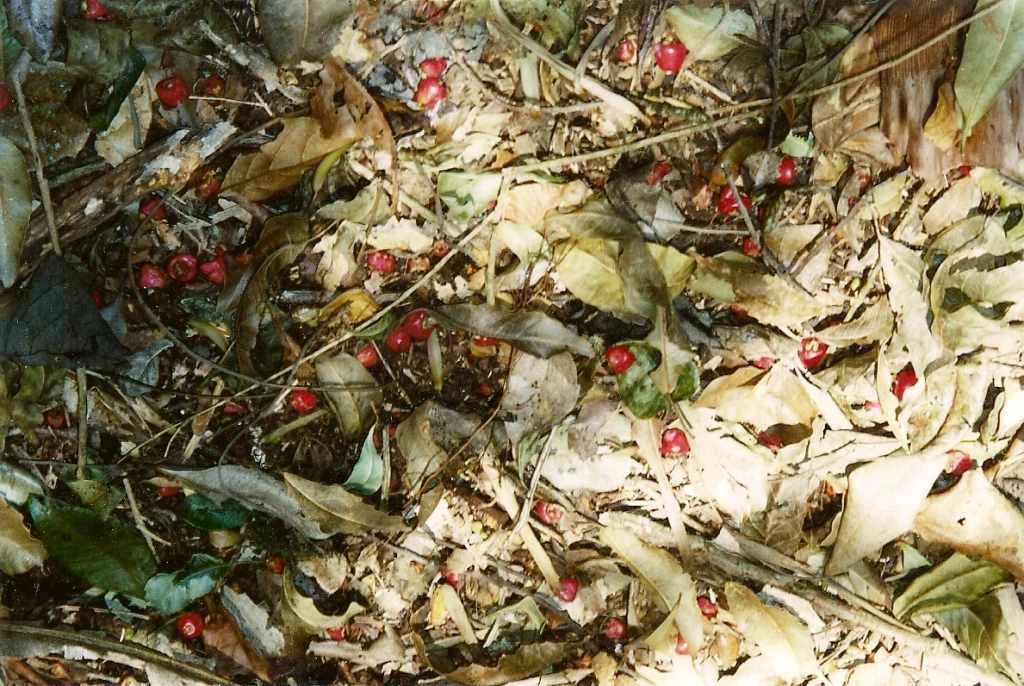
Top-down view of a forest floor covered in dried leaves, twigs, and small, spherical red fruits scattered throughout.
Red fruits of the Syzygium corynanthum tree scattered among forest floor leaf litter in Gumbaynggirr State Conservation Area.

Gumbaynggirr State Conservation Area conservation status and protection priorities

The conservation significance of the reserve rests on its role as one of the remaining strongholds of unlogged subtropical rainforest on the Mid North Coast of New South Wales. Many of the surrounding forests were historically cleared or selectively harvested, so areas like the League Scrub have become increasingly important reservoirs of original rainforest structure, species composition, and genetic diversity.

By combining an unlogged rainforest remnant with an additional forest area protected through community action against logging, the conservation area represents both an ecological and a policy success. Its 73 recorded tree species illustrate the value of protecting small but botanically rich rainforest patches, and the volcanic bench setting provides a distinctive habitat type within the broader state reserve network.

At a regional level, the reserve contributes to habitat connectivity and to the long term survival of east coast subtropical rainforest taxa under NSW National Parks and Wildlife Service management. Its creation also reflects a wider shift in forest policy in New South Wales, in which community led campaigns for specific forests played a significant role in expanding the state's protected area estate.

Gumbaynggirr State Conservation Area cultural meaning and human context

The name of the conservation area acknowledges the Gumbaynggirr people, the Aboriginal Traditional Owners of the surrounding Mid North Coast landscape. The use of the language name in the park's official title reflects the importance of recognising traditional custodianship alongside formal environmental protection in modern New South Wales reserve naming.

The reserve also carries a strong contemporary community history. The blockade that saved the Little Wonder section from logging in 1992 became a defining moment for local environmental activism on the Mid North Coast, and the eventual inclusion of that forest in the conservation area is remembered as a tangible outcome of sustained grassroots effort. Together, these layers of Indigenous heritage and recent community history give the reserve a cultural identity that complements its ecological role.

Top sights and standout views in Gumbaynggirr State Conservation Area

The League Scrub is the headline highlight of the conservation area: a compact, unlogged subtropical rainforest with a towering 40 metre canopy clothed in yellow carabeen, Moreton Bay fig, and a suite of other native trees. The presence of pumice on the forest floor offers a vivid reminder of the volcanic geology beneath the reserve.

Equally important is the former Little Wonder section, a stand of rainforest whose protection traces back to a year long anti logging blockade in 1992. Its inclusion in the conservation area underlines the role of community driven protection in shaping today's reserve system.

For visitors and researchers alike, the conservation area stands out as a compact but unusually rich example of east coast subtropical rainforest, sitting on fertile basaltic soils at around 750 metres elevation on the Mid North Coast of New South Wales.

Best time to visit Gumbaynggirr State Conservation Area

Because the reserve centres on tall subtropical rainforest at relatively high elevation, conditions inside the forest remain cool, shaded, and humid throughout much of the year. Visits in warmer months can feel particularly lush, with active growth in the understorey and strong displays of ferns and vines, though wet weather is more likely at that time.

Cooler months generally offer drier tracks and a more comfortable climate for walking through dense, sheltered rainforest, while the canopy itself remains evergreen and structurally dramatic in any season. As with most small, elevation dependent rainforest reserves in the region, planning around weather and early morning light tends to give the most rewarding experience of the forest interior.

Monthly climate preview

Long-term representative temperature and precipitation patterns across the conservation area

Gumbaynggirr State Conservation Area Climate Normals and Annual Weather Rhythm

Historical data recordings illustrate the measured annual temperature progression and daily precipitation rates at a representative coordinate within Gumbaynggirr State Conservation Area. Detailed monthly breakdowns provide deeper insight into long-term climate trends and multi-month environmental variations across the protected landscape.
Annual mean16 °C
10 °C22 °C
Jan22°
Feb21°
Mar19°
Apr16°
May13°
Jun11°
Jul10°
Aug11°
Sep14°
Oct17°
Nov19°
Dec21°
Warmest month
January

21.8 °C

Coolest month
July

9.8 °C

Wettest month
February

6.2 mm/day

Driest month
July

1.3 mm/day

Park location guide

Geography guide, regional context, and park location map for Gumbaynggirr State Conservation Area

Gumbaynggirr State Conservation Area park geography, regions, and map view in Australia

Understand where Gumbaynggirr State Conservation Area sits in Australia through a broader geographic reading of the surrounding landscape, nearby location context, and its mapped position within the national park landscape.

How Gumbaynggirr State Conservation Area fits into Australia

Australia is a constitutional monarchy and federal parliamentary democracy comprising six states and ten territories. With a population of nearly 28 million, it is one of the world's most urbanised countries, with most people concentrated on the eastern seaboard. The country has a high Human Development Index and is known for its cultural diversity, ancient Aboriginal heritage, and unique wildlife.

Wider geography shaping Gumbaynggirr State Conservation Area in Australia

Australia occupies the entire Australian continent, the island of Tasmania, and numerous smaller islands. It is the world's flattest and driest inhabited continent, featuring vast deserts in the interior (the Outback), tropical rainforests along the eastern coast, and a coastline bordering the Indian and Pacific Oceans.

Map view of Gumbaynggirr State Conservation Area

Use this park location map to pinpoint Gumbaynggirr State Conservation Area in Australia, understand its exact geographic position, and read its mapped placement within the surrounding landscape more clearly.

Pigeon | © OpenStreetMap contributors

Location context for Gumbaynggirr State Conservation Area

New South Wales

Visualizing the terrain, subtropical canopy, and protected habitats of New South Wales

Gumbaynggirr State Conservation Area Photos, Landscapes, and Forest Scenery

Visual records reveal the enclosed forest terrain, towering subtropical canopy, and volcanic basalt soils that define Gumbaynggirr State Conservation Area. Examining these protected area photographs provides clear insight into the unlogged rainforest structure and dense vegetation layers of the reserve.

A low-angle view looking up a tall, thick tree trunk in a dense subtropical rainforest, with multiple long, thin vines trailing down the trunk and surrounding foliage including broad leaves and ferns.

A close-up view of a large, deeply veined green leaf covered in numerous small holes caused by insect feeding.

A close-up view of a porous, light-colored pumice stone sitting on green grass or forest floor vegetation.

Top-down view of a forest floor covered in dried leaves, twigs, and small, spherical red fruits scattered throughout.

Park atlas

Compare surrounding regional park geography and connected eastern forest reserves.

Parks Near Gumbaynggirr State Conservation Area And Related Protected Landscapes

Browsing other protected areas near Gumbaynggirr State Conservation Area reveals the broader ecological context of the Mid North Coast region. Evaluating adjacent forest reserves helps connect isolated rainforest remnants to wider regional conservation patterns.
National parkNew South Wales
Park boundaries overlap#1 closest

Southeast

Dunggir National Park: Protected Subtropical Rainforest and Biodiversity Hub in New South Wales

Mapped national park landscape and Gumbaynggirr cultural context.

Dunggir National Park offers a detailed view into Australia's protected natural areas, specifically highlighting the unique subtropical rainforest environments of New South Wales. With a focus on conservation, this national park preserves a dense mosaic of three distinct rainforest types and is a sanctuary for significant biodiversity, including multiple endangered species. Its geographic placement and designation as a national park make it a key location for understanding regional ecosystems and the indigenous Gumbaynggirr heritage, with the park's name honouring the culturally significant koala.

Area
25 km²
Established
1997
IUCN
II
Relief
Upland
National parkNew South Wales
5.7 km away#2 closest

West

New England National Park: Escarpment Landscape and Protected Area Discovery in New South Wales

Explore dramatic cliffs, ancient rainforests, and diverse ecosystems.

New England National Park represents a critical protected landscape on the eastern edge of New South Wales' Northern Tablelands. This area is characterized by its spectacular escarpment country, featuring impressive cliffs, rugged ridges, and deep valleys that cradle some of Australia's most botanically rich environments. As a designated national park, it preserves ancient ecosystems and offers unique opportunities for atlas-based geographic discovery of its mapped terrain and wilderness character.

Area
673 km²
Established
1937
IUCN
Ib
Relief
Mountain
National parkNew South Wales
18 km away#3 closest

Northeast

Bellinger River National Park: Protected River Landscape and Forested Terrain in New South Wales

Explore mapped boundaries and geographic context.

Bellinger River National Park is a protected national park situated in New South Wales, Australia, renowned for its untouched upper river catchment and dense old-growth forests. The park offers valuable insights into the region's natural geography, featuring steep valleys, numerous waterfalls, and a significant river corridor. This page provides detailed information on its protected landscape, mapped boundaries, and geographic setting, essential for atlas-style discovery and understanding its ecological significance.

Area
28.3 km²
Established
1997
IUCN
II
Relief
Mixed relief
National parkNew South Wales
23 km away#4 closest

Northeast

Dorrigo National Park: National Park Geography and Mapped Protected Landscape

Explore the regional context and unique geographic boundaries of this New South Wales park.

Dorrigo National Park serves as a significant protected area within the broader geographic tapestry of New South Wales. This entry offers detailed insights into its mapped boundaries and landscape characteristics, positioning it within Australia's network of national parks. Users seeking structured geographic information and an atlas-style understanding of protected lands will find valuable context here, focusing on the park's inherent natural features and regional setting.

Area
119 km²
Established
1967
IUCN
II
Relief
Highland
National parkNew South Wales
25 km away#5 closest

West

Cunnawarra National Park: Exploring Its Protected Landscape and Mapped Geography

New South Wales National Park Atlas Entry

Cunnawarra National Park offers a specific lens through which to understand Australia's protected areas and regional geography. This detailed entry focuses on the park's identity as a designated national park, highlighting its mapped boundaries and its place within the broader landscape of New South Wales. Users can investigate the park's natural terrain and its contribution to conservation, making it a valuable point for structured geographic discovery.

Area
158 km²
Established
1999
IUCN
II
Scope
Terrestrial
Nature reserveNew South Wales
About 26 km away#6 closest

Southeast

Ngambaa Nature Reserve: A Detailed Geographic Overview of Coastal Hinterland Landscapes

Protected rainforest and ironbark mosaic in New South Wales

Ngambaa Nature Reserve preserves a distinct ecological transition zone in the Mid North Coast. This overview covers the reserve's topography, from sheltered gullies supporting rainforest remnants to drier slopes dominated by ironbark woodland, while detailing its role as a sanctuary for threatened species and a repository for cultural history.

Area
105.6 km²
Established
1999
IUCN
II
Relief
Upland
National parkNew South Wales
31 km away#7 closest

Southwest

Carrai National Park National Park: Protected Landscape and Geographic Context in New South Wales

Discover mapped boundaries and regional terrain.

Carrai National Park represents a key protected area within the New South Wales region. This detail page provides a focused look at its national park designation, offering insights into its specific geographic location and the character of its natural landscape. Understand its role in the national atlas and how its protected boundaries contribute to the regional geography.

Area
104 km²
Established
1999
IUCN
II
Relief
Upland
National parkNew South Wales
About 32 km away#8 closest

Southeast

Yarriabini National Park: National Park Protected Landscape Discovery in New South Wales

Explore mapped boundaries and regional geographic context.

Yarriabini National Park is a key protected area situated within the geographic expanse of New South Wales, Australia. This national park offers a clear case for understanding distinct landscape units and their mapped coverage. Within MoriAtlas, this profile facilitates a structured exploration of the park's protected status, its relationship to the surrounding terrain, and its contribution to the broader atlas of Australian conservation landscapes.

Area
20.92 km²
Established
2003
IUCN
II
Relief
Upland

Common questions about visiting, size, designation, and location context for Gumbaynggirr State Conservation Area

Gumbaynggirr State Conservation Area FAQs for park facts, access, geography, and protected area context

Find quick answers about Gumbaynggirr State Conservation Area, including protected-area facts, park geography, trail and visitor context, and how the park fits into its surrounding country and regional landscape.
MoriAtlas Explorer

Continue Your Protected Areas Search Across the Global Atlas

Deepen your exploration by continuing the structured search for national parks and protected areas worldwide. Utilize the comprehensive filtering capabilities to compare different conservation landscapes and refine your understanding of global park geography. Discover more about the distribution and characteristics of protected natural areas.

Global natural geography