

Mori Atlas logo
National parkGunung Buda National Park

Understand the geographic setting and protected land context of this Malaysian Borneo national park.

Gunung Buda National Park: Sarawak National Park with Mapped Protected Boundaries

Gunung Buda National Park stands as a designated national park within the diverse geography of Sarawak, Malaysia. Situated on the island of Borneo, this protected area offers a specific geographic focus for atlas exploration, detailing its mapped boundaries and its place within the regional landscape. Understanding Gunung Buda National Park provides essential context for exploring the protected natural areas of East Malaysia and the broader Borneo region.

limestone karstcave systemstropical rainforestBorneodipterocarp forestkarst landscape

Gunung Buda National Park

National park

Park overview

Structured park overview, official facts, and landscape profile for Gunung Buda National Park

Gunung Buda National Park park facts, protected area profile, and essential visitor context
Review the core facts for Gunung Buda National Park, including designation, size, terrain, visitor scale, habitats, and operating context in one park-focused overview.

About Gunung Buda National Park

Gunung Buda National Park represents one of Sarawak's more recent additions to its protected area network, established in 2001 to preserve a distinctive landscape of limestone karst, tropical rainforest, and significant cave systems. The park sits in Limbang Division, a region of Sarawak that lies between the Malaysian state of Sabah and the Brunei enclave, making it geographically positioned between some of Borneo's most significant protected landscapes. The park's proximity to Gunung Mulu National Park, which is recognized as a World Heritage Site, indicates the geological and ecological significance of this area. The landscape is dominated by the dramatic peak of Mount Buda, a limestone mountain whose name in the Lun Bawang language means White Hill, referencing the pale-colored rock formations that characterize the terrain. The mountain is separated from neighboring Mount Benarat by Medalem Gorge, a steep-sided valley that cuts through the karst landscape. While the park remains in early stages of tourism development, the underlying natural values include extensive cave systems, diverse forest types, and the biological richness typical of Bornean lowland and montane rainforests.

Quick facts and research context for Gunung Buda National Park

Gunung Buda National Park occupies 66.2 square kilometers in the Limbang Division of Sarawak, Malaysia, on the island of Borneo. The park's centerpiece is Mount Buda, rising 963 meters above sea level, separated from Mount Benarat by Medalem Gorge. The area experiences a consistently wet tropical climate with daily temperatures reaching the low 30s Celsius. The park was established in 2001 and remains relatively undeveloped, with tourism planning still underway as of 2017. The name Gunung Buda derives from the Lun Bawang language, meaning White Hill, referencing the distinctive pale limestone formations that characterize the landscape.

Park context

Deeper park guide and search-rich context for Gunung Buda National Park

Gunung Buda National Park history, landscape, wildlife, and travel context
Explore Gunung Buda National Park through its history, landscape character, ecosystems, wildlife, conservation priorities, cultural context, and seasonal travel timing in a structured park guide built for atlas discovery and search intent.

Why Gunung Buda National Park stands out

Gunung Buda National Park is best known for its extensive underground cave systems, which have been explored by American expeditions between 1993 and 2000, revealing more than 60 kilometers of surveyed cave passages beneath the mountain. The park shares the extraordinary karst limestone landscape of the Mulu region, one of the world's most important tropical karst ecosystems. The biodiversity of the surrounding rainforests is remarkable, hosting at least 300 bird species, numerous primate species, more than 2,500 tree species, and over 60 snake species. The variety of forest types within the park, including limestone forest, lowland dipterocarp forests, kerangas swamp forests, and upland dipterocarp forests, creates a complex ecological mosaic representative of Borneo's diverse habitats.

Gunung Buda National Park history and protected-area timeline

The exploration history of Gunung Buda National Park is closely tied to the pioneering cave explorations that began in the wider Mulu region in the late 1970s. British cavers first discovered the entrances to major caves such as Deer Cave and Clearwater Cave in 1978 during expeditions to what is now Gunung Mulu National Park. These discoveries prompted further exploration throughout the surrounding karst landscape, eventually extending to the caves beneath Gunung Buda. American explorers first visited Gunung Buda in 1993 when John Lane and George Prest assessed the mountain's potential for speleological research. The first formal American expedition followed in late 1994 and early 1995, with subsequent expeditions conducted in 1996, 1997, and 2000. Members of the National Speleological Society participated in the 1997 expeditions. Collectively, these expeditions surveyed more than 60 kilometers of cave passages beneath Gunung Buda, establishing the mountain as a significant site within one of the world's most extensive cave systems. The park was officially gazetted as a national park in 2001, formalizing protection for this cave-rich landscape.

Gunung Buda National Park landscape and geographic character

The landscape of Gunung Buda National Park is defined by its dramatic limestone karst topography, a characteristic feature of the Mulu region in northern Sarawak. The park's central feature, Mount Buda, rises to 963 meters above sea level, standing as a prominent limestone peak within the surrounding terrain. The mountain is separated from the imposing form of Mount Benarat by Medalem Gorge, a steep canyon that illustrates the powerful geological forces that have shaped this karst landscape over millions of years. The terrain varies considerably, with steep slopes, vertical cliff faces, and deep ravines typical of limestone mountainous areas. The underlying geology consists primarily of limestone formations that have been eroded over time to create the extensive cave systems for which the region is famous. Surface drainage patterns reflect the complex relationship between the solid rock and the underground cavern systems that channel water through the limestone mass.

Gunung Buda National Park ecosystems, habitats, and plant life

The ecological character of Gunung Buda National Park reflects the remarkable biodiversity of Borneo's tropical rainforests, combined with the specialized habitats created by the park's varied topography and multiple forest types. The interaction between elevation changes, substrate composition, and drainage patterns has produced amosaic of distinct vegetation communities within the relatively limited area of the park. Limestone forest develops on the rocky, calcium-rich substrates of the karst peaks, supporting specialized plant species adapted to these conditions. The lower slopes and valley floors support lowland dipterocarp forests, the dominant forest type of Borneo's lowlands, characterized by the tall Dipterocarpaceae family trees that can exceed 60 meters in height. Kerangas swamp forests occupy poorly drained areas, with distinctive vegetation adapted to waterlogged conditions and nutrient-poor soils. Upland dipterocarp forests occur at higher elevations, where the forest composition shifts to species better suited to the cooler, more humid conditions of the montane zone. This forest diversity supports the extraordinary species richness documented in the broader Mulu region.

Gunung Buda National Park wildlife and species highlights

The wildlife communities of Gunung Buda National Park are part of the exceptionally biodiverse ecosystems of northern Sarawak, an area recognized as a global center of tropical biodiversity. The rainforests of Buda and the neighboring Mulu region host at least 300 bird species, representing a remarkable avifauna that includes numerous endemic and specialized species. Primates are well represented in the forest canopy, with several species present including orangutans, gibbons, and macaques that inhabit the different forest layers. The tree species diversity is extraordinary, with more than 2,500 species recorded in the broader area, providing the structural complexity that supports diverse animal communities. Reptiles are represented by more than 60 snake species, ranging from highly cryptic forest-floor species to more visible arboreal forms. The various forest types within the park, from limestone forest to kerangas swamp, create habitat heterogeneity that supports different species assemblages, contributing to the overall biodiversity richness that makes this area one of the most significant natural areas in Southeast Asia.

Gunung Buda National Park conservation status and protection priorities

Gunung Buda National Park contributes to the protection of a globally significant karst ecosystem within the heart of Borneo's tropical rainforest biome. The establishment of the park in 2001 formalized protection for an area that contains extensive cave systems, diverse forest types, and the biological richness characteristic of the Mulu region. The park's proximity to Gunung Mulu National Park, a World Heritage Site, reinforces the conservation significance of this landscape, as both protected areas work together to preserve the ecological and geological values of the northern Sarawak karst region. The protection of multiple forest types within the park, including limestone forest, lowland dipterocarp, kerangas swamp, and upland dipterocarp, ensures the preservation of different ecological communities and the species they support. The cave systems beneath Gunung Buda represent a unique underground environment that requires protection from disturbance, and the national park designation provides the framework for managing these sensitive geological features.

Gunung Buda National Park cultural meaning and human context

The name Gunung Buda carries cultural significance rooted in the indigenous Lun Bawang language, one of the languages spoken by communities in the border regions of Sarawak, Sabah, and the Kalimantan province of Indonesia. The translation of the name as White Hill reflects the visual character of the limestone peaks that dominate the landscape, where pale-colored rock formations create a distinctive appearance against the deep green of the surrounding rainforest. The Lun Bawang people are among the indigenous communities with historical connections to the landscapes of northern Sarawak, though the specific cultural history of human interaction with the Gunung Buda area is not extensively documented in the available sources. The park exists within a region of complex territorial boundaries, as Limbang Division lies between the Malaysian state of Sabah and the Brunei Darussalam enclave, a geographic circumstance that has influenced the administrative and development history of the area.

Top sights and standout views in Gunung Buda National Park

Gunung Buda National Park protects one of Borneo's most geologically spectacular landscapes, characterized by towering limestone karst peaks, deep gorges, and extensive underground cave systems stretching more than 60 kilometers in surveyed passages. The park shares the extraordinary biodiversity of the Mulu region, where 300 bird species, over 2,500 tree species, and diverse primate communities inhabit the multiple forest types that span from valley floors to mountain slopes. The relatively recent establishment of the park in 2001 and its location immediately north of the World Heritage-listed Gunung Mulu National Park position it as a significant addition to Borneo's protected area network. The distinctive name White Hill, from the Lun Bawang language, captures the visual identity of the pale limestone peaks that define the park's most recognizable landmarks.

Best time to visit Gunung Buda National Park

Gunung Buda National Park experiences a consistently wet tropical climate throughout the year, with rainfall occurring in all seasons and daily temperatures typically reaching the low 30s Celsius. The maintained wet conditions mean that the rainforest environment remains lush and the cave systems continue to function year-round, though the wet season may bring more challenging conditions for surface exploration. The park was in planning stages for tourism development as of 2017, indicating that visitor facilities and access may be limited. Those planning to visit the wider Mulu region, which would logically include consideration of Gunung Buda, should be prepared for tropical conditions with high humidity and the possibility of rainfall at any time.

Park location guide

Geography guide, regional context, and park location map for Gunung Buda National Park

Gunung Buda National Park park geography, regions, and map view in Malaysia
Understand where Gunung Buda National Park sits in Malaysia through a broader geographic reading of the surrounding landscape, nearby location context, and its mapped position within the national park landscape.

How Gunung Buda National Park fits into Malaysia

Malaysia is a federal constitutional monarchy located in Southeast Asia. The country consists of 13 states and three federal territories, divided by the South China Sea into Peninsular Malaysia on the Indochinese Peninsula and East Malaysia on the island of Borneo. With a population of over 34 million, it achieved independence from Britain in 1957 and became a modern federation in 1963. The country is recognized for its multicultural population, tropical climate, and significant economic role in the region.

Wider geography shaping Gunung Buda National Park in Malaysia

Malaysia occupies a strategic position in Southeast Asia, split by the South China Sea into two distinct regions. Peninsular Malaysia lies on the Indochinese Peninsula, sharing a land border with Thailand to the north and maritime borders with Singapore, Vietnam, and Indonesia. East Malaysia occupies the northern portion of Borneo, sharing land borders with Brunei and Indonesia, and maritime borders with the Philippines and Vietnam. The country's terrain includes coastal plains, mountain ranges such as the Titiwangsa in the peninsula, and extensive tropical rainforests.

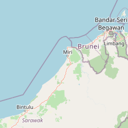
Map view of Gunung Buda National Park

Use this park location map to pinpoint Gunung Buda National Park in Malaysia, understand its exact geographic position, and read its mapped placement within the surrounding landscape more clearly.

Pigeon | © OpenStreetMap contributors

Location context for Gunung Buda National Park

Sarawak
Park atlas

Trace the mapped geography and protected-area spread across the distinctive karst landscapes of Malaysian Borneo.

Browse Protected Areas, National Parks, and Regional Geography Surrounding Gunung Buda National Park
Explore additional national parks and protected areas found across the distinctive karst and tropical rainforest landscapes of Malaysian Borneo. Map their regional spread and compare conservation efforts to understand the broader network of protected natural areas beyond Gunung Buda National Park.
National parkMarudi District

Gunung Mulu National Park: A Protected National Park with Distinct Geographic Identity in Marudi District

Explore its mapped protected area and regional landscape.

Gunung Mulu National Park stands as a key protected area within Marudi District, Malaysia, offering critical insights into the region's natural geography. This national park entity provides a focal point for understanding mapped protected landscapes and their specific geographic characteristics. Users can explore the park's boundaries and its role within the wider atlas of Malaysian natural areas, gaining a solid foundation in its conservation geography.

Area
528.64 km²
Established
1974
IUCN
II
Relief
Mountain
National parkBrunei

Ulu Temburong National Park: Brunei's Protected Rainforest Landscape and Geographic Context

Mapped natural terrain and conservation significance.

Ulu Temburong National Park represents Brunei's commitment to preserving its most ecologically significant tropical rainforests, covering approximately 550 square kilometers. This protected area is characterized by its remote location in the Temburong District and its diverse topography, ranging from lowland areas to mountainous ridges, all within a largely undisturbed natural setting. The park's mapped boundaries encompass a vital transboundary conservation landscape, making it a key site for understanding Borneo's unique ecosystems and forest protection policies through an atlas-driven exploration approach.

Area
488.59 km²
Established
1991
IUCN
II
Relief
Mixed relief
Protected areaBrunei

Tasek Merimbun Heritage Park: Protected Landscape Identity and Geographic Atlas

Mapped boundaries and regional natural context for this Brunei protected area.

Tasek Merimbun Heritage Park represents a distinct protected area within the geography of Brunei. This page provides detailed insight into its protected landscape, offering a map-centric view of its boundaries and its placement within the broader natural context of Borneo. Understand the park's geographic significance and explore its unique attributes for structured atlas exploration.

Area
78 km²
Established
1984
Climate
Tropical
Access
Easy access
Nature reserveBrunei

Luagan Lalak Forest Recreation Park Nature Reserve: Brunei's Pristine Freshwater Swamp Landscape

Explore mapped protected-area geography and unique wetland terrain.

Luagan Lalak Forest Recreation Park, a protected nature reserve in Brunei, preserves a rare and visually distinctive freshwater swamp ecosystem. Characterized by dark, tranquil waters and vast fields of purun grass, this natural wetland offers a unique landscape context and is a prime location for observing its rich biodiversity, especially its notable birdlife. The park's preservation as an intact swamp environment within a recreational area highlights its ecological importance for regional geography and protected-area mapping.

Area
2.7 km²
Established
1980
IUCN
II
Visitors
4.2K annual
Nature reserveTemburong District

Peradayan Forest Reserve Nature Reserve: Understanding its Protected Landscape and Geographic Setting

Explore mapped boundaries and the natural terrain of this Brunei reserve.

Peradayan Forest Reserve stands as a significant protected natural area within Brunei's Temburong District, an exclave characterized by vast tropical rainforests. This entry focuses on its identity as a nature reserve, providing key geographic context and details about its mapped boundaries. Understand its role within the regional landscape and how its protected status contributes to the conservation of Brunei's natural heritage, facilitating a deeper dive into atlas-style geographic exploration.

Area
26.5 km²
Relief
Upland
Climate
Tropical
Access
Moderate access
Protected areaBrunei-Muara District

Bukit Shahbandar Forest Recreation Park: Protected Area with Ridge Landscape & Hiking Trails

Explore Brunei's unique recreational forest terrain and mapped natural features.

Bukit Shahbandar Forest Recreation Park is a notable protected area within the Brunei-Muara District, distinguished by its prominent grassy ridge and a network of challenging hiking trails that traverse its varied terrain. The park's landscape is characterized by rolling hills, including peaks that reach nearly 470 feet, offering strategic vantage points. As a recreational forest, it provides a distinct example of protected land use, blending modified natural vegetation with opportunities for outdoor activity and geographic discovery. Its unique topography and trail system offer a clear focus for atlas-based exploration.

Area
2.34 km²
Established
1998
IUCN
II
Visitors
35.5K annual
National parkLimbang Division

Pulong Tau National Park: A Protected National Park in Malaysia's Limbang Division

Explore its mapped boundaries and regional landscape context.

Pulong Tau National Park represents a key protected area within the Limbang Division, offering valuable geographic and atlas-based discovery opportunities. This page details the park's identity as a national park, focusing on its mapped boundaries and its role within the protected landscapes of Malaysia. Users can explore the park's specific geographic characteristics and understand its context within the regional atlas, providing a factual foundation for appreciating its natural landscape value.

Area
665.25 km²
Established
1998
IUCN
II
Relief
Mountain
National parkSarawak

Loagan Bunut National Park: Protected Landscape in Sarawak, Malaysia

Explore the mapped geography and natural terrain of this national park.

This page offers a detailed atlas-style exploration of Loagan Bunut National Park, situated in Sarawak, Malaysia. Understand the park's designation as a national park and its place within the mapped geography of Borneo. It provides essential context for appreciating the protected landscape and its regional significance.

Area
100 km²
Established
1990
IUCN
II
Scope
Terrestrial

Common questions about visiting, size, designation, and location context for Gunung Buda National Park

Gunung Buda National Park FAQs for park facts, access, geography, and protected area context
Find quick answers about Gunung Buda National Park, including protected-area facts, park geography, trail and visitor context, and how the park fits into its surrounding country and regional landscape.
MoriAtlas Explorer

Continue Your Protected Areas Search Across the Global Atlas

Deepen your exploration by continuing the structured search for national parks and protected areas worldwide. Utilize the comprehensive filtering capabilities to compare different conservation landscapes and refine your understanding of global park geography. Discover more about the distribution and characteristics of protected natural areas.

Global natural geography
