
Mori Atlas logo
Protected landscapeGwennap Head

Trace the coastal geography, Atlantic terrain, and maritime boundaries of this protected headland

Gwennap Head: Mapped Granite Cliffs and Protected Coastal Landscapes of West Cornwall

Gwennap Head serves as a prominent granite headland on the Penwith peninsula in Cornwall, showcasing a dramatic intersection of Atlantic weather and rugged igneous geology. This protected landscape encompasses sheer cliffs, complex sea stacks, and exposed maritime heathlands that support diverse passage seabirds. Visitors can examine the mapped boundaries of this coastal area, which includes the famous Chair Ladder crag and historic maritime daymarks, providing a comprehensive look at the region's natural and seafaring heritage.

granite cliffsAtlantic headlandCornwall coastPenwith Heritage Coastmaritime heathseabird passage
A flat-style digital illustration depicting a rocky headland with cliffs and evergreen trees overlooking a calm ocean bay under a setting sun.

Gwennap Head

Protected landscape

Park overview

Structured park overview, official facts, and landscape profile for Gwennap Head

Gwennap Head park facts, protected area profile, and essential visitor context

Review the core facts for Gwennap Head, including designation, size, terrain, visitor scale, habitats, and operating context in one park-focused overview.

About Gwennap Head

Gwennap Head is the most southerly headland on the Penwith peninsula in far western Cornwall, a windswept promontory where ancient granite meets the Atlantic. The peninsula juts westward toward Land's End and the Isles of Scilly, and Gwennap Head sits between those landmarks and the fishing cove of Porthgwarra, facing south toward the English Channel. The cliffs drop steeply into deep water, cut by gullies, sea caves, and a famous blowhole that opens onto the sea below, producing a coastline that is as dramatic as any in southwest Britain.

The headland lies within a protected landscape mosaic. It is part of the Penwith Heritage Coast, the Cornwall Area of Outstanding Natural Beauty, and the Porthgwarra to Pordenack Point Site of Special Scientific Interest, while the South West Coast Path runs along its cliff tops. Beyond the cliffs, the offshore Runnel Stone reef is now enclosed within a Marine Conservation Zone designated in 2016, extending ecological protection from the heath-covered cliff tops down into the surrounding sea.

Gwennap Head combines several strands of interest in a small area. Naturalists come for its waved maritime heath, plant rarities such as perennial centaury, and exceptional seawatching. Climbers are drawn to the granite crags, particularly the Chair Ladder. Walkers follow the South West Coast Path through some of the most photographed scenery in Cornwall. At the same time, the headland carries a layered maritime history of lookouts, shipwrecks, daymarks, and modern coastwatch activity, making it a place where natural and human coastal history are tightly intertwined.

Quick facts and research context for Gwennap Head

Gwennap Head sits on the south coast of the Penwith peninsula in Cornwall, within the parish of St Levan and roughly four miles south of Land's End. It falls inside both the Penwith Heritage Coast and the Cornwall Area of Outstanding Natural Beauty, while the South West Coast Path closely follows its cliff edge. The cliffs form part of the Land's End granite massif, with shallow, acidic, free-draining soils that support waved maritime heath, maritime grassland, and rare plant species including perennial centaury.

The headland is included in the Porthgwarra to Pordenack Point Site of Special Scientific Interest for its vegetation and ornithological value, and the adjoining Runnel Stone Marine Conservation Zone protects roughly twenty square kilometres of coastal and offshore habitat out to the Runnel Stone reef. A pair of nineteenth-century Trinity House navigation daymarks, the Cones of the Runnel, still warn vessels of submerged rocks, and a former coastguard station now operates as an NCI watch station.

Protection and recognition

Documented protection history and official conservation designations

Gwennap Head Protection Status and International Recognition Records

Gwennap Head maintains a mixed protection scope established in the designated year 2016 for regional conservation oversight. Structured records track the official protected area designation and management framework without international recognition sources.

Protection details

Protection scope
Mixed
Designated year
2016
Transboundary protection
No
Park context

Deeper park guide and search-rich context for Gwennap Head

Gwennap Head history, landscape, wildlife, and travel context

Explore Gwennap Head through its history, landscape character, ecosystems, wildlife, conservation priorities, cultural context, and seasonal travel timing in a structured park guide built for atlas discovery and search intent.

Why Gwennap Head stands out

Gwennap Head is best known as a seabird migration watchpoint, where passage species such as great shearwater, Cory's shearwater, Balearic shearwater, northern gannet, Manx shearwater, and auks pass close to the cliffs. The headland's exposure to Atlantic weather and its position off the Runnel Stone reef make it one of the most productive seawatching sites in southwest England, attracting birdwatchers from across Britain during spring and autumn passage. It is equally recognized for its dramatic granite cliff scenery, including the famous Chair Ladder climbing crag and the historic blowhole that gives the older name Tol-Pedn-Penwith its meaning. Historic daymarks, shipwrecks, and the NCI coastwatch station give the headland a strong maritime character that complements its natural history value.
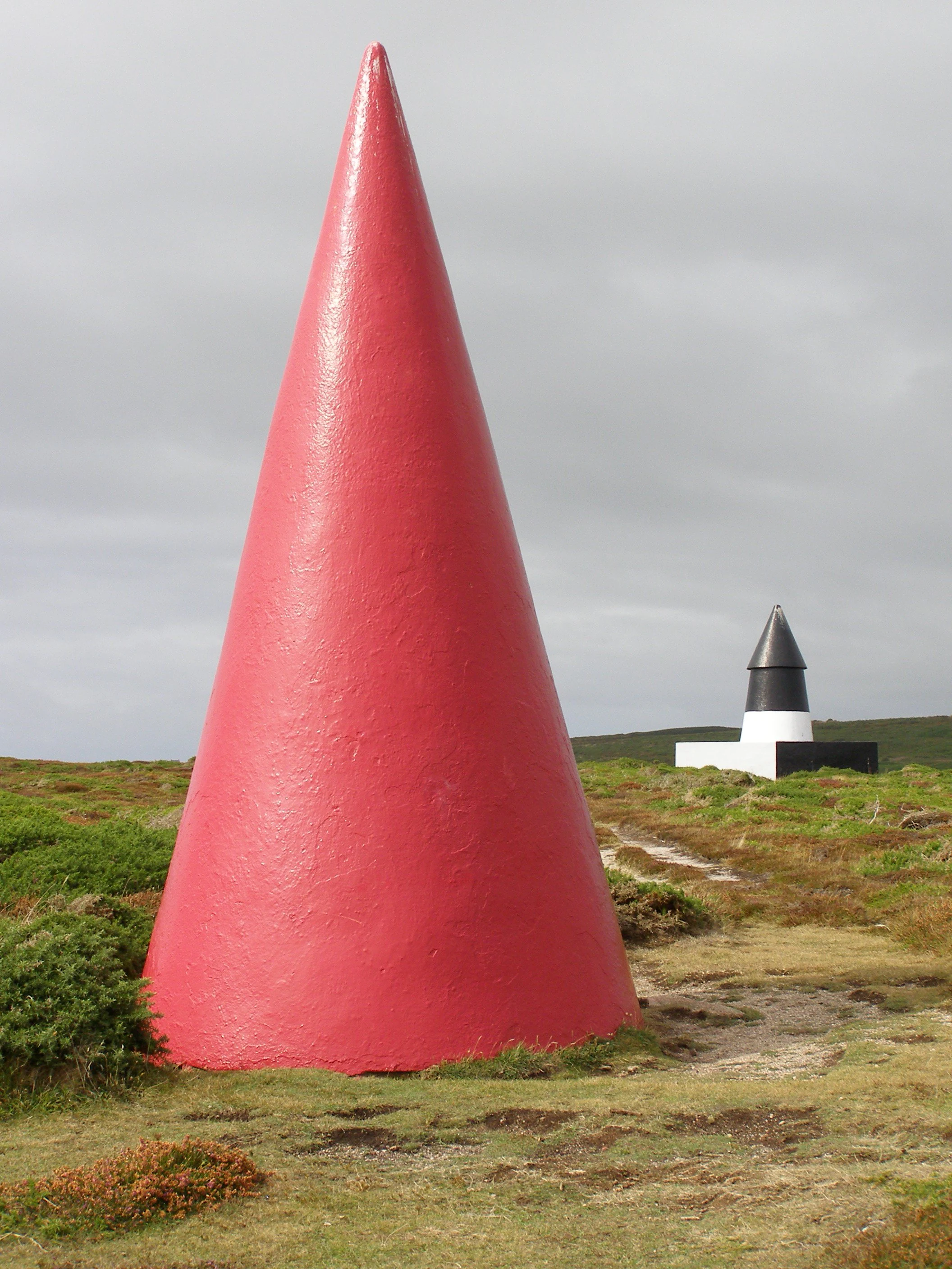
A large, bright red conical navigation daymark stands in the foreground, with a smaller black and white conical daymark visible in the grassy distance under an overcast sky.
Trinity House navigation daymarks at Gwennap Head.

Gwennap Head history and protected-area timeline

Gwennap Head carries two names that tell different parts of its story. The older form, Tol-Pedn-Penwith, is Cornish for the holed headland of Penwith, referring to the spectacular blowhole that opens from the cliff top down through a sea cave. Until the late nineteenth century the headland was effectively considered Land's End itself; the present location of that name lies a few miles further north. Early nineteenth-century writers sometimes distinguished the two by calling the headland St Leven's Land's End, while the modern Land's End was labelled Sennen Land's End, and Cape Cornwall was also among features once collectively called Land's End.

The headland became known as Gwennap Head from 1888, possibly after a local family, although the new name did not enter everyday use on the ground until the 1970s. Throughout this period the land was part of historic farms and estates; in 1887 Roskestral Farm was auctioned and included Tol Pedn Penwith, the Funnel Hole, and parts of Carn Glaze Common, and the wider area has remained with the St Aubyn Estate.

Evidence of much older human presence can still be traced nearby. Early nineteenth-century antiquarians reported an ancient stone wall separating Tol-Pedn from the mainland, possibly interpreted as a defensive feature, and in the 1840s H. McLauchlan reported faint traces of a Bronze Age tumulus on the summit. Although these traces have since disappeared, the site continues to attract archaeological interest. The coast itself also carries a history of loss at sea, including the 1905 wreck of the barque Kyber at Porth Loe, where only three crew were rescued and the rest are buried in a mass grave at St Levan church.

Maritime oversight of the headland stretches back centuries. Photographs and early maps show successive signal stations, semaphore apparatus, and Union flag hoists before 1801. The current prominent lookout building was begun around 1905 as a one-storey Coastguard station and was expanded after a French trawler, the Vert Prairial, was wrecked unseen on nearby rocks in 1956. The Coastguard station closed in 1994 and reopened as NCI Gwennap Head in 1996, continuing a tradition of watching ships at the tip of Cornwall.

Gwennap Head landscape and geographic character

The cliffs of Gwennap Head belong to the Land's End granite massif, the ancient igneous backbone of western Cornwall that has been shaped by Atlantic weather over millions of years. Where the sea meets the granite, the result is an intricate coastline of vertical cliffs, narrow gullies, boulder-strewn coves, stacks, and arches. The Chair Ladder crag is the most famous individual feature, a varied granite cliff that has made the headland a focal point for recreational climbing of many grades.

Beneath the cliff line, the seabed continues the geology offshore in the Runnel Stone reef, a line of submerged rocks that has long been a hazard to shipping and frames the seascape around the headland. Inland, the soils remain thin, acidic, and free-draining, set directly on granite. They support low, open maritime heath rather than trees, with stretches of maritime grassland clinging to the cliff edges. The result is a landscape that reads as predominantly bare, open, and exposed, with subtle colour shifts through the seasons as heather, gorse, and coastal grasses come into flower.
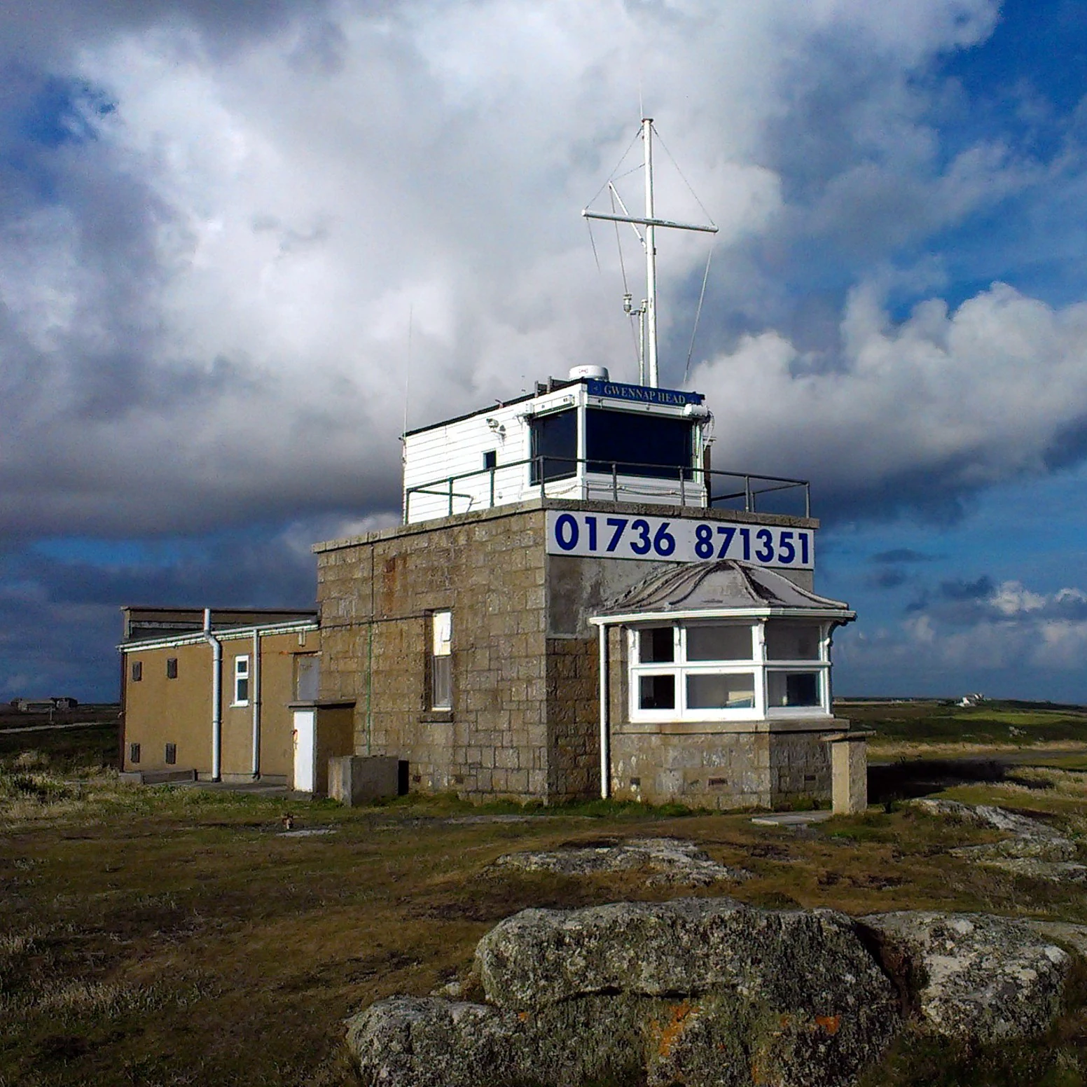
A small, stone-built lookout building with a white upper cabin and communications mast on a rocky, grassy headland under a cloudy sky.
The National Coastwatch Institution station situated on the granite headland of Gwennap Head.

Gwennap Head ecosystems, habitats, and plant life

Ecologically, Gwennap Head is defined by waved maritime heath, a low vegetation community shaped by salt spray, wind, and thin soils over granite. Heather, bell heather, and western gorse form the dominant structure across much of the cliff plateau, with colourful maritime grassland along the more exposed edges. These open habitats shelter numerous rare and nationally scarce plants, including perennial centaury, early meadow-grass, hairy bird's-foot trefoil, and yellow bartsia, alongside better-known flowers such as spring squill, thrift, sea campion, and kidney vetch.

The cliff-edge grasslands burst into colour in spring and early summer, then give way to purple and yellow tones as the heathers and gorses bloom later in the season. The land has been kept in good ecological condition by traditional grazing; the return of cattle under a stewardship agreement is credited with helping perennial centaury recover at the site after decades of apparent absence.

Insect life is rich for such an exposed place. Resident butterflies include common species such as large white, small copper, common blue, small tortoiseshell, peacock, comma, grayling, and speckled wood. On warm days and particularly during migration periods, clouded yellow, red admiral, and painted lady butterflies are recorded moving along the coast. Migrant moths such as rush veneer, silver Y, and hummingbird hawk-moth also appear at the headland, drawn along the same pathways that funnel birds and other wildlife past the cliffs.
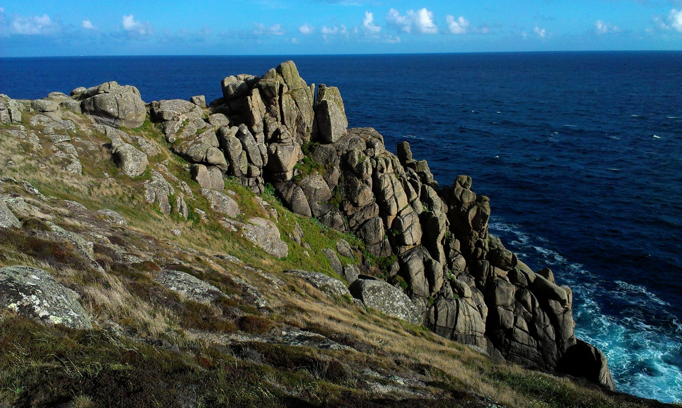
Rugged granite rock cliffs rising above the dark blue ocean at Gwennap Head.
Granite cliff formations at Gwennap Head, Cornwall.

Gwennap Head wildlife and species highlights

Gwennap Head is primarily celebrated for its birdlife, both resident and migratory. The cliffs, sea caves, and adjoining waters support breeding seabirds including northern fulmar, European shag, cormorant, common guillemot, and razorbill, along with northern gannets feeding offshore. Red-billed choughs have bred on the headland in recent years, a notable success in a region where this species is cherished.

The offshore passage is what draws birdwatchers from across Britain. Spring and especially autumn see strong movements of seabirds past the cliffs, including Manx shearwater, great shearwater, Cory's shearwater, and the critically watched Balearic shearwater. Land-based migrants also pass through: waders, ducks, larks, and finches are frequently recorded at peak times in May and October.

Marine wildlife is another major attraction. Basking sharks and ocean sunfish are regular seasonal visitors in the richer offshore waters, while grey seals, whales, and dolphins are also recorded from the seawatching point. Occasional extreme rarities, including a red-billed tropicbird seen over the Runnel Stone in 2015, illustrate how unusual tropical species can also drift into the area.

Gwennap Head conservation status and protection priorities

Gwennap Head sits within a layered conservation framework. On land, the headland forms part of the Porthgwarra to Pordenack Point Site of Special Scientific Interest, recognizing the value of its waved maritime heath and its role as a migration watchpoint for birds. It is also covered by the Penwith Heritage Coast and the broader Cornwall Area of Outstanding Natural Beauty, providing additional protection for its landscape character.

At sea, the Runnel Stone Marine Conservation Zone, designated in 2016, protects about twenty square kilometres of habitat ranging from exposed coastal rock down to soft sediments on the seabed. The zone was drawn as an arc from the NCI lookout and extends along the coast toward Logan Rock on the east side of Treryn Dinas.

Management on the headland has combined designation with active stewardship. Grazing reintroduced under environmental stewardship agreements has been linked to the recovery of key plant species, while coordinated volunteer seawatching, including the Seawatch SW survey organized from 2007 to 2011, has generated long-term records of marine wildlife that underpin conservation decisions. The ongoing work of the NCI station adds a continuous human presence focused on safety and environmental awareness.

Gwennap Head cultural meaning and human context

The cultural identity of Gwennap Head is rooted in Cornish language and maritime tradition. The older name Tol-Pedn-Penwith preserves the Cornish sense of the landscape, naming the headland from the distinctive blowhole that pierces it. Throughout the nineteenth and twentieth centuries the headland remained part of large landed estates, with the St Aubyn family holding the area, and the parish of St Levan providing the local community backdrop.

The headland also occupies a place in wider British maritime culture. The Cones of the Runnel feature as a navigational landmark in Hammond Innes's thriller The Trojan Horse, and the lookouts, semaphore, and daymarks illustrate a continuous tradition of watching and warning ships at the tip of Cornwall. Wreck lore is woven into local memory, with stories such as the loss of the Kyber in 1905 still connected to the nearby churchyard at St Levan, where many of the lost sailors are buried. The National Coastwatch station continues this tradition in modern form.

Top sights and standout views in Gwennap Head

Gwennap Head offers an unusually concentrated package: rare waved maritime heath with nationally scarce plants such as perennial centaury; some of the finest passage seabird watching in southwest England; a dramatic granite cliffscape crowned by the climbing crag Chair Ladder; a founded blowhole and sea caves reached by the South West Coast Path; and a continuous story of maritime oversight marked by Trinity House daymarks, historic wrecks, and the active NCI lookout.

Best time to visit Gwennap Head

The character of Gwennap Head shifts noticeably through the year, and the most rewarding time to be there depends on what a visitor wants to see. Late spring, especially May, brings peak land-bird migration, with waders, finches, and other passerines moving along the headland; it is also when the maritime grassland is at its most colourful, with spring squill, thrift, sea campion, and kidney vetch in flower.

Midsummer is quieter but warms up the cliff-edge butterflies, while late summer and early autumn, from July into October, are the classic seawatching season, when shearwaters, including the great and Cory's shearwaters that breed far out in the Atlantic, pass close inshore alongside gannets, fulmars, and auks. Basking sharks and ocean sunfish are also more likely in these warmer months. The maritime heath itself comes into its strongest purple and yellow tones later in summer as heather and western gorse bloom. Winter visits are calmer and emptier, with stormy seas adding drama to the cliffs but reducing wildlife observation opportunities.
Monthly climate preview

Long-term representative point measurements tracking monthly averages across the coastal landscape

Gwennap Head Climate Normals: Measured Annual Temperature and Precipitation Rhythm

Representative coordinates record measured monthly temperature and precipitation rhythms across the protected landscape over a multi-year period. Examining the complete twelve-month profile reveals detailed baseline climate normals and seasonal variations for structured geographic analysis.
Annual mean12 °C
9 °C17 °C
Jan
Feb
Mar
Apr10°
May12°
Jun14°
Jul16°
Aug17°
Sep16°
Oct14°
Nov12°
Dec10°
Warmest month
August

16.7 °C

Coolest month
February

8.8 °C

Wettest month
November

3.9 mm/day

Driest month
May

2 mm/day

Park location guide

Geography guide, regional context, and park location map for Gwennap Head

Gwennap Head park geography, regions, and map view in United Kingdom

Understand where Gwennap Head sits in United Kingdom through a broader geographic reading of the surrounding landscape, nearby location context, and its mapped position within the national park landscape.

How Gwennap Head fits into United Kingdom

The United Kingdom is a parliamentary constitutional monarchy located in northwestern Europe, consisting of four constituent countries: England, Scotland, Wales, and Northern Ireland. As a major global power with over 69 million residents, it maintains significant international influence in politics, economics, and culture.

Wider geography shaping Gwennap Head in United Kingdom

The United Kingdom is an island nation located in northwestern Europe, surrounded by the Atlantic Ocean, North Sea, English Channel, Celtic Sea, and Irish Sea. It shares a land border with the Republic of Ireland to the west. The territory includes the island of Great Britain, the northeastern portion of Ireland, and most of the smaller British Isles islands.

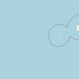
Map view of Gwennap Head

Use this park location map to pinpoint Gwennap Head in United Kingdom, understand its exact geographic position, and read its mapped placement within the surrounding landscape more clearly.

Pigeon | © OpenStreetMap contributors

Location context for Gwennap Head

Cornwall

Visual reference collection for coastal habitats, sea stacks, and protected headland terrain

Gwennap Head Photos, Scenery, and Dramatic Granite Cliff Landscapes

Visual records capture the rugged granite cliffs, exposed coves, and maritime heath defining Gwennap Head. Examining these photographs helps observers understand the severe Atlantic exposure and unique coastal habitats shaping the headland.

A large, bright red conical navigation daymark stands in the foreground, with a smaller black and white conical daymark visible in the grassy distance under an overcast sky.

A high-angle view of rugged granite cliffs overlooking a turquoise sandy cove, with grassy headlands stretching into the distance along a coastline.

A small, stone-built lookout building with a white upper cabin and communications mast on a rocky, grassy headland under a cloudy sky.

Rugged granite rock cliffs rising above the dark blue ocean at Gwennap Head.

Park atlas

Compare adjacent granite coastlines and regional protected landscapes

Explore Parks Near Gwennap Head and Surrounding Coastal Protected Areas

Continue browsing other parks near Gwennap Head to examine comparable granite cliffs, maritime heath habitats, and coastal protected areas. Comparing these adjacent regional landscapes reveals broader patterns in Atlantic shoreline geography and wildlife migration routes.
A soft watercolor illustration depicting a coastal landscape with green marshy vegetation, a calm body of water, and rolling hills in the background.
Marine protected areaCornwall
About 19 km away#1 closest

East

Mounts Bay Marine Conservation Zone: Exploring Marine Protected Areas in South Cornwall

Subtidal reefs and coastal seagrass habitats in the English Channel.

This protected marine landscape off the coast of Cornwall covers diverse underwater habitats including the Greeb reef and the waters surrounding St Michael's Mount. The area is characterized by its significant seagrass beds, which act as vital nursery habitat for fish and shellfish species. Explore the structural geography of this marine protected area and its position within the broader coastal environment of South West England.

Area
12 km²
Established
2016
Relief
Lowland
Climate
Temperate
Marine protected areaCornwall
About 45 km away#2 closest

East

The Manacles Marine Protected Area: Coastal Geography and Underwater Reef Map

Detailed geographic analysis of the Lizard Peninsula marine environment

The Manacles serves as a critical marine protected area featuring an intricate layout of jagged rock clusters, maerl beds, and historical shipwreck sites. This atlas entry provides a structured look at the reef geography, submerged terrain characteristics, and the environmental significance of this landmark formation within the waters of Falmouth Bay.

Area
3.5 km²
Established
2013
Relief
Lowland
Climate
Temperate
A watercolor illustration featuring soft, abstracted layers of green hills, a light blue horizon, and subtle pink and earthy tones representing land and water.
Protected areaCornwall
About 57 km away#3 closest

Northeast

River Gannel Protected Area: Cornwall Coastal Estuary and Marine Conservation Zone

Mapped tidal channels and coastal landscape geography in Cornwall

River Gannel provides a focal point for understanding the tidal geography of northern Cornwall. From its inland source to the dynamic estuary separating Newquay and Crantock, the area features protected marine habitats, sand dunes, and deep-rooted industrial heritage. This record details the physical boundaries and ecological significance of this coastal landscape as it drains into the Celtic Sea.

Established
2016
Relief
Lowland
Climate
Temperate
Access
Easy access
Watercolor illustration of Dartmoor moorland landscape with rolling hills, grassy vegetation, a stream, and distant mountains.
National parkDevon
About 121 km away#4 closest

Northeast

Dartmoor National Park: Granite Tors and Prehistoric Landscape in Devon

Mapped protected area with significant Bronze Age remains.

Dartmoor National Park represents a distinctive granite upland in Devon, England, characterized by its dramatic tors and expansive moorland. This protected landscape is globally significant for its dense concentration of prehistoric archaeological sites, including stone circles, standing stones, and ancient settlements. Exploring Dartmoor offers a unique insight into Britain's regional geography, mapped terrain, and enduring connection to ancient human history.

Area
954 km²
Established
1951
IUCN
V
Visitors
11M annual
A soft watercolor illustration featuring rolling hills in the background, a tree line in the midground, and a winding waterway in the foreground.
Biosphere reserveDevon
About 148 km away#5 closest

Northeast

North Devon's Biosphere Reserve: Protected Landscapes and Geographic Map Exploration

Coastal dunes, estuaries, and marine habitats in North Devon

An extensive overview of North Devon's Biosphere Reserve, highlighting its role as a protected landscape in South West England. Analyze the distribution of its diverse terrain, including Britain's largest sand dune system, river catchments, and offshore coral reefs, through detailed geographic and habitat mapping.

Area
5,262 km²
Established
1976
Visitors
4M annual
Relief
Lowland
Watercolor painting depicting a landscape with rolling hills, a winding road, and distant mountains
National parkUnited Kingdom
About 174 km away#6 closest

Northeast

Exmoor National Park: A Premier Protected Landscape in South West England for Atlas Exploration

Mapped terrain, moorland, and dramatic coastal geography.

Discover Exmoor National Park, a vast protected area in South West England celebrated for its sweeping heather moorland, dramatic coastline with the highest sea cliffs on mainland Britain, and deep, ancient wooded valleys. This national park offers a unique landscape for atlas-based exploration, revealing its distinct geography, mapped boundaries, and rich terrain shaped by centuries of natural processes and human activity.

Area
692 km²
Established
1954
IUCN
V
Visitors
1.4M annual
Watercolor painting of a coastline with rolling green cliffs meeting the sea, with small pink flowers in the foreground.
Protected landscapeUnited Kingdom
About 175 km away#7 closest

East

Jurassic Coast Protected Landscape: Geological Mapping and Coastal Atlas

A comprehensive look at sedimentary formations in the United Kingdom

Trace the 96-mile stretch of the Jurassic Coast, a protected landscape revealing Triassic, Jurassic, and Cretaceous rock layers. The terrain serves as a vital record of Earth history, featuring distinctive geomorphological landmarks like Chesil Beach and the towering cliffs of Golden Cap, all defined by the dynamic interaction of land and sea.

Established
2001
Relief
Upland
Climate
Temperate
Access
Easy access
A soft, painterly watercolor illustration of a winding river flowing through green marshlands, coastal dunes, and gentle rolling hills under a bright, open sky.
Nature reserveFinistère
About 180 km away#8 closest

Southeast

Réserve naturelle régionale des marais, dunes et baies de Guissény: Protected Atlas Detail

Coastal reserve geography and maritime landscape mapping

Located in Finistère, this protected area features an intricate network of reedbeds, dune ridges, and coastal lagoons. The reserve provides a critical refuge for over 200 bird species and serves as a prime example of the land-and-sea ecological transition characteristic of the northern Breton coastline.

Area
6.083 km²
Established
2025
IUCN
IV
Relief
Lowland

Common questions about visiting, size, designation, and location context for Gwennap Head

Gwennap Head FAQs for park facts, access, geography, and protected area context

Find quick answers about Gwennap Head, including protected-area facts, park geography, trail and visitor context, and how the park fits into its surrounding country and regional landscape.
MoriAtlas Explorer

Continue Your Protected Areas Search Across the Global Atlas

Deepen your exploration by continuing the structured search for national parks and protected areas worldwide. Utilize the comprehensive filtering capabilities to compare different conservation landscapes and refine your understanding of global park geography. Discover more about the distribution and characteristics of protected natural areas.

Global natural geography