Mori Atlas logo
National parkГыданский национальный парк

Mapping the geographic extent of Western Siberia northernmost protected conservation complex and Kara Sea island systems.

Гыданский национальный парк: A Comprehensive Atlas of Arctic Tundra and Protected Coastal Landscapes

(Национальный парк «Гыданский»)

Гыданский национальный парк represents a critical conservation zone within the Yamalo-Nenets Autonomous Okrug, spanning the Gydan Peninsula and surrounding Kara Sea islands. This expansive Arctic landscape showcases a complex interplay of permafrost, tundra vegetation, and marine-influenced wetlands that serve as essential habitat along the East Atlantic Flyway. The park geography encompasses a unique mosaic of thermokarst terrain, river-dissected lowlands, and coastal spits, offering a detailed look at the transition between terrestrial Siberian ecosystems and the harsh maritime conditions of the Arctic coast.

Arctic tundraRussian ArcticKara Seaislandscoastal ecosystemsmigratory birds

Гыданский национальный парк

National park

Park overview

Structured park overview, official facts, and landscape profile for Gydansky National Park

Gydansky National Park park facts, protected area profile, and essential visitor context

Review the core facts for Gydansky National Park, including designation, size, terrain, visitor scale, habitats, and operating context in one park-focused overview.

About Gydansky National Park

Gydansky National Park spans the northern reaches of the Gydan Peninsula in the Russian Arctic, encompassing a sweeping territory where the West Siberian Plain meets the Kara Sea. It occupies a transitional position between the great tundra plains further south and the sea, making it a critical zone for ecological processes that link terrestrial, freshwater, and marine systems. The park's territory includes peninsulas such as Yavai, the northern and northwestern parts of the Mamonta Peninsula, the Oleniy Peninsula, segments of the Yuratskaya Bay coast, and a chain of offshore islands that includes Oleniy, Shokalsky, the Peskovye islands, the Proklyatye islands, and Rovny Island.

The protected area functions as the northernmost natural conservation complex in Western Siberia. It extends the chain of protected Arctic shorelines and islands that begins further east along the Kara Sea coast, ensuring that a continuous ecological corridor remains intact for species that depend on Arctic conditions. The park's ecological value is enhanced by its position along the East Atlantic Flyway, where millions of waterbirds and shorebirds move seasonally between Arctic breeding grounds and more temperate wintering regions. By preserving undisturbed tundra, coastal lagoons, and island habitats, the park helps maintain the conditions these migratory populations rely upon.

Beyond its ecological profile, Gydansky is also notable for its cultural landscape. Indigenous Nenets and Enets communities have long lived in and moved through this territory, practising traditional reindeer herding, hunting, fishing, and seasonal gathering. The national park framework legally recognizes a zone of traditional extensive land use within its boundaries, allowing these communities to continue their customary economic activities under regulated conditions. The area thus represents an important example of how conservation, indigenous rights, and the protection of fragile Arctic ecosystems intertwine in the modern Russian north.

Quick facts and research context for Gydansky National Park

Gydansky National Park occupies roughly 878,174 hectares on the northern Gydan Peninsula and adjacent Kara Sea islands, with an additional buffer zone of about 150,000 hectares. The park lies in the Tazovsky District of the Yamalo-Nenets Autonomous Okrug, within Tyumen Oblast, and extends between approximately 71°40' and 73°10' north latitude. It was originally designated as the Gydansky Nature Reserve in 1996 and was reclassified as a national park by Russian Government decree in December 2024. The territory combines multiple peninsulas, coastal segments, and offshore islands such as Shokalsky Island, Oleniy Island, the Peskovye islands, the Proklyatye islands, and Rovny Island, forming one of the most northerly protected complexes in Western Siberia.

Protection and recognition

Documented protection history and official designation parameters for conservation analysis.

Гыданский национальный парк Protection Status and Designation Records

Official records outline the mixed protection status and designation history established for Гыданский национальный парк. Structured parameters assemble administrative timelines and conservation criteria for rigorous geographic reference.

Protection details

Protection scope
Mixed
Designated year
2024
Transboundary protection
No
Buffer area
1,500 km²
Park context

Deeper park guide and search-rich context for Gydansky National Park

Gydansky National Park history, landscape, wildlife, and travel context

Explore Gydansky National Park through its history, landscape character, ecosystems, wildlife, conservation priorities, cultural context, and seasonal travel timing in a structured park guide built for atlas discovery and search intent.

Why Gydansky National Park stands out

Gydansky National Park is best known for its role in protecting Arctic tundra ecosystems at the northern edge of Western Siberia and for conserving a key segment of the East Atlantic Flyway. The park lies along one of the most important migratory corridors for waterbirds and shorebirds in the Eurasian Arctic, connecting breeding grounds to the north with wintering areas far to the south. Its island and coastal mosaic is equally distinctive, combining peninsular tundra, lagoons, and Kara Sea islands into a single conservation unit. This combination of mainland tundra, transitional wetlands, and marine-influenced shorelands gives the park a unique ecological profile, bridging terrestrial Arctic habitats with the marine and coastal systems of the Kara Sea. The presence of indigenous Nenets and Enets communities, whose traditional land use is formally recognized within the park, adds another defining layer to the area's identity.
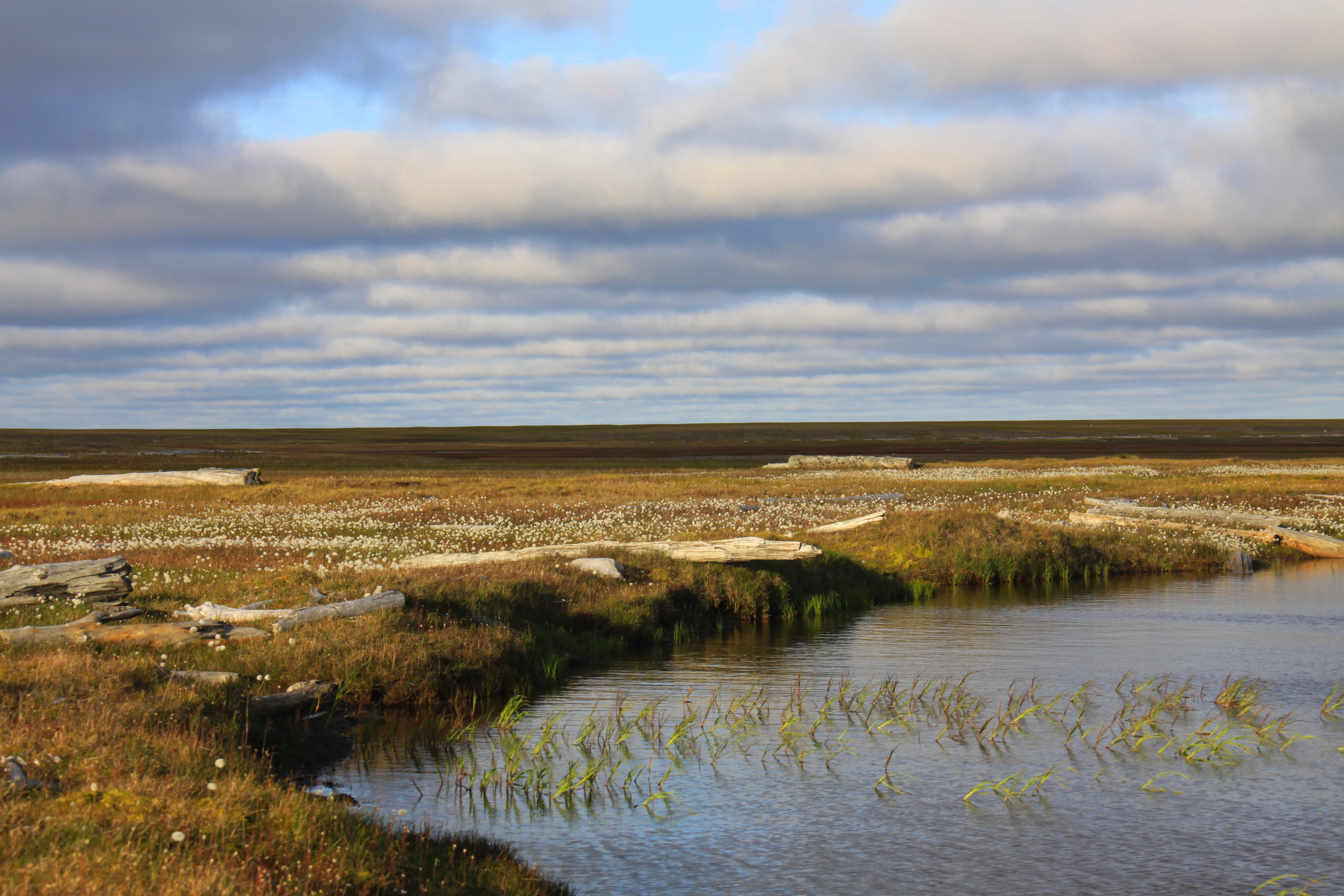
Tundra, Shokalsky Island
Landscape of Gydansky Nature Reserve in Tazovsky District, Yamalo-Nenets Autonomous Okrug

Gydansky National Park history and protected-area timeline

The idea of creating a protected area on the Gydan Peninsula developed from late 1970s and 1980s discussions about establishing a combined Yamalo-Gydan nature reserve. In 1991, regional authorities decided to split this concept into two separate reserves, one for the Yamal side and one for Gydan, but the Russian Ministry of Natural Resources at first rejected the proposal due to opposition from the oil and gas sector and concerns from local reindeer herding enterprises. Only the most northern parts of the peninsula, areas not expected to see industrial development in the near future, were ultimately protected.

In 1995, a second, revised project was prepared, and in October 1996 the Russian Government officially approved the creation of the Gydansky Nature Reserve, covering 878,174 hectares across five separate clusters. Although the reserve was legally established in 1996, it only began active operations in 2001, when its first director was appointed. The reserve's reduced size compared with original proposals meant that typical southern tundra habitats of the Gydan Peninsula were excluded from protection, and many conservation scientists argued that the reserve was not fully representative of the peninsula's ecosystems.

A major shift occurred in December 2024, when the Russian Government issued a decree transforming the Gydansky Nature Reserve into Gydansky National Park. The reclassification was presented in part on the grounds that traditional land use by Nenets and Enets communities was incompatible with the strict zapovednik regime. The new national park format allows regulated economic activities within the protected area under zoned management, a change that has been welcomed by indigenous advocates while also raising concerns among environmentalists about the long-term integrity of the territory.

Gydansky National Park landscape and geographic character

The landscape of Gydansky National Park is defined by the broad sweep of the northern Gydan Peninsula, a low-lying Arctic landmass shaped by permafrost, glacial history, and the slow erosive work of rivers and the sea. Tundra dominates the surface, marking a long transition from the more sheltered habitats to the south toward the harsher conditions of the Arctic coast. The terrain is generally flat to gently rolling, dissected by numerous rivers, streams, and thaw lakes that are typical of the Siberian tundra.

Along the coast, the landscape changes character. The Yuratskaya Bay coast, with its embayments, spits, and tidal flats, forms a transitional interface between land and the Kara Sea. The park's offshore islands extend this marine influence further, with Shokalsky Island, Oleniy Island, the Peskovye islands, the Proklyatye islands, and Rovny Island each contributing their own combination of beach ridges, low cliffs, tundra patches, and seabird nesting terrain. Together, these islands and coastal features create a mosaic of microhabitats that interact closely with the broader Arctic seascape.

Within this setting, seasonal change is dramatic. Long winters lay down a continuous snow cover over the tundra, while the brief but intense Arctic summer awakens a flush of tundra vegetation, fills thaw lakes and wetlands, and draws in enormous populations of migratory birds. The interplay of low light, vast open horizons, and the shifting surface of the sea gives the park a distinctly remote Arctic character that defines both its geography and its ecological identity.

Gydansky National Park ecosystems, habitats, and plant life

Gydansky National Park protects a representative slice of the northern Gydan Peninsula's Arctic ecosystems, centred on tundra landscapes that range from moss and lichen communities to graminoid-dominated habitats and coastal wetlands. The summers are short but biologically intense, supporting a network of thaw lakes, polygonal tundra formations, and wet depressions that act as feeding and breeding grounds for many species. These habitats are part of a broader ecological continuity that links the protected area to other conservation sites along the Kara Sea coast.

The park's combination of mainland tundra and offshore islands creates a layered ecological system. Onshore habitats give way to brackish lagoons, estuarine zones, and saltwater shorelines along the Yuratskaya Bay and the broader Kara Sea, providing a wide spectrum of ecological niches. The islands, being isolated from terrestrial predators and disturbances, often serve as especially important refuges for nesting seabirds and waterbirds. The park's location along the East Atlantic Flyway further amplifies its ecological importance, as seasonal pulses of migratory birds connect the park to wider hemispheric ecological networks.

The local climate is fully Arctic and strongly seasonal, with permafrost influencing soil development, vegetation patterns, and hydrology across the entire territory. This cold climate restricts tree growth, leaving the landscape in a state of open tundra, and shapes the biological rhythms of every species living there. Taken together, these factors give Gydansky a clearly Arctic ecological identity that is broadly representative of the circumpolar north while still being shaped by the unique West Siberian setting.

Gydansky National Park wildlife and species highlights

The wildlife of Gydansky National Park is typical of the high Arctic tundra and the transitional Kara Sea coast, where terrestrial and marine influences meet. The tundra supports resident species adapted to open, treeless landscapes and long winters, while the coast and offshore islands function as crucial breeding and staging habitat for waterbirds and shorebirds. The park's islands, in particular, provide refuge conditions for nesting colonial seabirds and migrating waterfowl, benefiting from their isolation and the availability of food from surrounding sea waters.

Seasonal abundance is a defining feature. During the brief Arctic summer, the park comes alive with migratory birds moving along the East Atlantic Flyway, drawing species that travel between the Arctic and more temperate latitudes. The mix of freshwater thaw lakes, coastal lagoons, beaches, and tundra pools creates an exceptional range of feeding conditions for these visitors. Beyond birds, the park also harbours the typical suite of Arctic mammals, including reindeer, Arctic fox, and other tundra-adapted species, while the surrounding Kara Sea supports marine life associated with the broader Arctic ecosystem.

For indigenous communities such as the Gydan Nenets and Enets, this wildlife base has long formed the foundation of traditional hunting, fishing, and reindeer husbandry. Their continued presence within the park contributes to the dynamic character of the local fauna, as seasonal movements of reindeer herds intersect with the migrations of wild species, creating a layered ecological and cultural interaction across the landscape.

Gydansky National Park conservation status and protection priorities

Gydansky National Park holds substantial conservation significance as the northernmost protected area in Western Siberia and as an important component of the broader network of Arctic reserves along the Kara Sea coast. By protecting northern Gydan tundra and adjacent islands, the park preserves habitats that are otherwise vulnerable to climate-driven warming, permafrost degradation, and expanding industrial activity. Its inclusion of multiple peninsulas, coastal stretches, and offshore islands makes it a rare example of a fully integrated Arctic terrestrial-marine conservation unit in this part of Russia.

A central element of the park's conservation role lies in its position along the East Atlantic Flyway, which is one of the most significant migratory corridors for waterbirds and shorebirds in the northern hemisphere. By securing undisturbed feeding, resting, and breeding habitat across both mainland and island environments, Gydansky helps ensure that this flyway retains functional continuity in an era of accelerating environmental change. The conservation of these habitats is not only important for the flyway itself but also for the linked ecosystem processes that extend across continents.

The conversion of the former nature reserve into a national park in 2024 represents both an opportunity and a challenge. While the national park framework continues to protect the core landscape and its ecological functions, it also opens the door to regulated traditional and potentially other economic activities. The effectiveness of the long-term conservation of Gydansky will depend on how these zoning decisions are implemented, especially in the context of expanding oil and gas development on the peninsula. The park thus stands as a notable case study in how Arctic conservation must navigate competing pressures, indigenous land-use rights, and the steady growth of industrial infrastructure in one of Russia's most remote regions.

Gydansky National Park cultural meaning and human context

The Gydan Peninsula is home to small indigenous populations of Gydan Nenets and Enets, two groups whose traditional ways of life are closely tied to the Arctic environment. For generations, these communities have relied on reindeer herding, hunting, fishing, and seasonal gathering of wild plants, moving across the tundra in patterns that reflect both the productivity of the land and the rhythms of the seasons.

The national park framework formally recognizes a zone of traditional extensive land use within the territory, allowing these communities to continue their economic activities in regulated coexistence with conservation goals. This dual recognition of natural and cultural values reflects an evolving Russian approach to protected area management, acknowledging that the Gydan landscape is not only an ecological system but also a living cultural space shaped by human presence.

At the same time, the region faces serious cultural pressures. Industrial development, including major natural gas extraction and liquefied natural gas projects on the peninsula, has disrupted traditional land use elsewhere in the Yamalo-Nenets Autonomous Okrug. Concerns have been raised that the loss of broader territory surrounding the park could eventually concentrate indigenous communities within the national park itself, potentially turning it into a cultural refuge rather than a homeland embedded within a wider functional landscape. This tension between conservation, industrial growth, and indigenous continuity forms an important part of the contemporary cultural context of Gydansky National Park.

Top sights and standout views in Gydansky National Park

Gydansky National Park stands out for the sheer scale of its Arctic tundra coverage, the diversity of coastal and island environments it bundles into a single protected area, and its pivotal role along the East Atlantic Flyway. Few protected areas in Western Siberia combine expansive mainland tundra, active thermokarst landscapes, and a network of offshore Kara Sea islands in this way.

The park's identity is also shaped by its ongoing negotiation between ecological protection, indigenous land use, and the pressures of regional industrial development. Its transformation from a strict nature reserve into a national park in 2024 marks a turning point in how this balance is being recalibrated, and the outcome will be significant for both conservation science and the indigenous communities who call the Gydan Peninsula home.

Monthly climate preview

Long-term representative monthly temperature and precipitation data measurements

Гыданский национальный парк Climate Normals and Annual Temperature Rhythm

Representative coordinate records show measured monthly temperature and precipitation patterns across twelve distinct periods for Гыданский национальный парк. Accessing the complete monthly profile provides deeper long-term climatology metrics for comparative regional research.
Annual mean-8 °C
-23 °C8 °C
Jan-23°
Feb-22°
Mar-17°
Apr-11°
May-4°
Jun
Jul
Aug
Sep
Oct-7°
Nov-17°
Dec-21°
Warmest month
July

8 °C

Coolest month
January

-22.5 °C

Wettest month
August

2.4 mm/day

Driest month
March

1 mm/day

Park location guide

Geography guide, regional context, and park location map for Gydansky National Park

Gydansky National Park park geography, regions, and map view in Russia

Understand where Gydansky National Park sits in Russia through a broader geographic reading of the surrounding landscape, nearby location context, and its mapped position within the national park landscape.

How Gydansky National Park fits into Russia

Russia is a transcontinental nation spanning eleven time zones, bordered by fourteen countries. It is the world's largest country by area, covering 17,098,246 km². Moscow is the capital and largest city, while Saint Petersburg is the second-largest and a major cultural centre.

Wider geography shaping Gydansky National Park in Russia

Russia spans Eastern Europe and North Asia, covering 17,098,246 km². It shares land borders with fourteen countries, more than any other nation, and spans eleven time zones. The landscape includes vast plains, mountain ranges such as the Urals and Caucasus, and extensive coastlines along the Arctic Ocean, Pacific Ocean, Baltic Sea, Black Sea, and Caspian Sea.

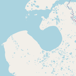
Map view of Gydansky National Park

Use this park location map to pinpoint Gydansky National Park in Russia, understand its exact geographic position, and read its mapped placement within the surrounding landscape more clearly.

Pigeon | © OpenStreetMap contributors

Location context for Gydansky National Park

Ямало-Ненецкий автономный округ

Visual exploration of Siberian tundra terrain, coastal habitats, and protected Kara Sea islands.

Гыданский национальный парк Photos, Landscapes, and Arctic Scenery

Visual documentation of Гыданский национальный парк reveals the vast scale of northern Arctic tundra, permafrost terrain, and remote coastal habitats. Examining these protected landscapes helps researchers and travelers understand the remote environment and migratory bird corridors of Western Siberia.

Tundra, Shokalsky Island

Park atlas

Compare adjacent Arctic tundra reserves and northern Siberian conservation lands

Other Parks Near Гыданский национальный парк and Regional Protected Areas

Browsing other protected areas near Гыданский национальный парк reveals broader regional patterns across the Siberian tundra and Kara Sea coastlines. Examining these adjacent wilderness landscapes provides essential context for understanding northern conservation networks.
Watercolor illustration of rolling green hills with distant mountains and a light sky
National parkRussia
About 554 km away#1 closest

Northwest

Russian Arctic National Park: Russia's Premier Northernmost Protected Landscape

Arctic Islands, Glacial Terrain, and Marine Mammal Habitats

Russian Arctic National Park preserves some of the planet's most remote and pristine Arctic environments across the Novaya Zemlya and Franz Josef Land archipelagos. This protected area offers unparalleled insight into Arctic geography, showcasing dramatic glacial landscapes, extensive seabird colonies, and critical feeding grounds for polar bears and bowhead whales. Explore the park's unique protected landscape and its significance within the broader atlas of global conservation efforts.

Area
14,260 km²
Established
2009
IUCN
II
Relief
Lowland
National parkKomi Republic
About 976 km away#2 closest

Southwest

Yugyd Va National Park: Protected Boreal Wilderness and Mountain Geography in the Komi Republic

Exploring Europe's largest protected taiga and Ural mountain ecosystems.

Yugyd Va National Park offers a comprehensive look at the high-altitude geography of the Ural Mountains and the surrounding boreal taiga. As the largest protected wilderness area in Europe, this site showcases a dramatic transition from ancient lowland forest floors to alpine tundra summits. The park map highlights significant river corridors and granite mountain ranges that define this remote, undisturbed ecological landscape in the Russian north.

Area
18,917 km²
Established
1994
IUCN
II
Visitors
4K annual
National parkKomi Republic
About 976 km away#3 closest

Southwest

Yugyd Va National Park in the Komi Republic: A Protected Atlas of Ural Wilderness

Virgin taiga forests, glacial peaks, and northern river basins

Yugyd Va serves as a critical conservation landscape in the Russian North, protecting a mosaic of ecosystems from dense coniferous forests to exposed glacial cirques. This expansive national park in the Komi Republic contains the highest summits of the Ural Mountains and hundreds of pristine lakes, offering a window into one of the least disturbed wilderness regions on the European continent.

Area
18,917 km²
Established
1994
IUCN
II
Visitors
6.7K annual
Watercolor painting of a mountainous landscape with green, purple, and yellow tones
National parkMurmansk Oblast
About 1,707 km away#4 closest

West

Khibiny National Park: Arctic National Park with Mapped Protected Boundaries in Murmansk Oblast

Explore Murmansk Oblast's unique protected landscape and regional geography.

Delve into the geography and protected landscape of Khibiny National Park, a significant national park situated in Russia's Murmansk Oblast. This resource provides essential details for understanding the park's mapped boundaries, its arctic terrain, and its position within the broader context of the Kola Peninsula's natural geography. Explore Khibiny National Park as a key protected area and a crucial element for atlas-based discovery of Russia's northwestern regions.

Area
848 km²
Established
2018
IUCN
II
Relief
Mountain
National parkFinnmark
About 1,718 km away#5 closest

West

Varangerhalvøya National Park: Explore Finnmark's Unique Subarctic Protected Landscape

Mapped tundra, wetlands, and Arctic fox conservation.

Varangerhalvøya National Park offers a compelling atlas exploration of Norway's northeasternmost protected landscapes. This national park in Finnmark is distinguished by its subarctic terrain, featuring expansive tundra, diverse wetlands, and a unique ecological position where multiple biomes converge. It is a critical habitat for the Arctic fox and a vital Important Bird Area, providing deep insights into protected area geography and landscape context for those studying regional conservation and natural formations.

Area
1,804.1 km²
Established
2006
IUCN
II
Relief
Lowland
National parkArkhangelsk Oblast
About 1,781 km away#6 closest

West

Onezhskoye Pomorye National Park: An Atlas of Protected Northern Taiga and Coastal Terrains

Exploring the glacial landscapes of Arkhangelsk Oblast

Onezhskoye Pomorye National Park serves as a significant protected corridor where large tracts of old-growth spruce and pine forest extend directly to the White Sea shoreline. The mapped terrain transitions from elevated glacial plains and moraine ridges to low-lying glacio-marine terraces, dunes, and migratory wetlands. This geographic record highlights the park's role in conserving boreal wilderness, salmon-rich rivers, and the historic cultural legacy of the Pomor people along the northern coast.

Area
2,016.68 km²
Established
2013
IUCN
II
Relief
Mixed relief
Watercolor painting of a coastal landscape featuring rolling hills, green vegetation, and a body of water under a soft sky
National parkSverdlovsk Oblast
About 1,785 km away#7 closest

Southwest

Pripyshminskiye Bory National Park: Explore its Protected Landscape and Geographic Setting

National Park with mapped boundaries in Sverdlovsk Oblast.

Pripyshminskiye Bory National Park stands as a notable protected area within the vast geography of Sverdlovsk Oblast, Russia. This page serves as a dedicated atlas entry for the park, detailing its protected landscape identity and its placement within the broader regional context. Users can investigate the park's mapped boundaries and understand its significance as a distinct national park, facilitating structured geographic discovery.

Area
490 km²
Established
1993
IUCN
II
Relief
Lowland
National parkSvalbard
About 1,788 km away#8 closest

Northwest

Sassen, Bünsow Land National Park: A Mapped Arctic Glacial Landscape in Svalbard

Explore protected boundaries and polar terrain.

Sassen, Bünsow Land National Park, located in the heart of Spitsbergen, Norway, showcases a quintessential Arctic wilderness defined by its expansive glacial features and deeply incised valleys. This protected area, part of the Svalbard archipelago, offers rich geographic context through its mapped terrain, highlighting glacial processes that have shaped the landscape. Discover the unique polar environment and the significance of this national park within the broader Norwegian Arctic atlas.

Area
1,230 km²
Established
2003
IUCN
II
Relief
Mountain

Common questions about visiting, size, designation, and location context for Gydansky National Park

Gydansky National Park FAQs for park facts, access, geography, and protected area context

Find quick answers about Gydansky National Park, including protected-area facts, park geography, trail and visitor context, and how the park fits into its surrounding country and regional landscape.
MoriAtlas Explorer

Continue Your Protected Areas Search Across the Global Atlas

Deepen your exploration by continuing the structured search for national parks and protected areas worldwide. Utilize the comprehensive filtering capabilities to compare different conservation landscapes and refine your understanding of global park geography. Discover more about the distribution and characteristics of protected natural areas.

Global natural geography