
Glaciers
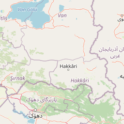
Park geography
Detailed spatial data covering mountain terrain, elevation, and regional geography in Turkey.
Geographic Profile and Boundary Analysis for Hakkari Cilo-Sat Mountains National Park
This geographic profile provides structural data for Hakkari Cilo-Sat Mountains National Park. It includes precise boundary coordinates, total area measurements of 275 square kilometers, and an elevation reach peaking at 4135 meters. The mapped region encompasses diverse mountain terrain, glacial lakes, and identified natural landmarks across the Yüksekova District.
Turkey's high-altitude glacial wilderness protecting the nation's second-highest peak
Hakkari Cilo-Sat Mountains National Park
Hakkari Cilo-Sat Mountains National Park is Turkey's 45th national park, established in September 2020 in the southeastern Anatolian region of Hakkari Province. The protected area encompasses the dramatic Cilo and Sat mountain ranges, which rise sharply from the surrounding landscape to form one of Turkey's most spectacular high-altitude environments. The park centers on Mount Cilo, whose summit Uludoruk reaches 4,135 meters, making it the second-highest peak in Turkey. The landscape is characterized by deep glacial valleys, active glaciers, numerous glacial lakes, alpine meadows, and dramatic vertical topography shaped by millions of years of glaciation. This relatively new protected area preserves a ecologically significant mountain ecosystem that supports rare endemic plant species, endangered wildlife including the Lake Urmia newt, and significant bird populations. The park represents Turkey's commitment to conserving its high-altitude biodiversity and geological heritage in the remote eastern reaches of the country.
- Location
- Turkey
- Park type
- National park
- Established
- 2020
- Area
- 275 km²
- Highest point
- 4,135 m
Location overview
Regional placement in Hakkari Province and Yüksekova District
Geography of Hakkari Cilo-Sat Mountains National Park in Turkey
Hakkari Cilo-Sat Mountains National Park is situated in Turkey's Hakkari Province and Yüksekova District. Map records designate it as a terrestrial interior reserve without transboundary, coastal, or marine zones.
- Countries
- Turkey
- Regions
- Hakkari Province, Yüksekova District
- Primary location
- Hakkari Province
- Geographic setting
- Inland
Boundary and coordinates
Spatial extent and geometric measurements covering 275 square kilometers
Hakkari Cilo-Sat Mountains National Park Boundary Map and Geographic Limits
Interactive boundary geometry outlines the spatial footprint and physical reach of the protected area. Geographic metrics detail the calculated land area, coordinate spans, and centre point coordinates.
- Boundary area
- 274.8 km²
- Boundary perimeter
- 122.7 km
- Northernmost point
- 37.5498° N
- Southernmost point
- 37.253° N
- Easternmost point
- 44.3847° E
- Westernmost point
- 43.9263° E
- Geographic centre
- 37.3973° N, 44.1594° E
- North–south span
- 32.9 km
- East–west span
- 40.6 km
Elevation and terrain
Mountain terrain relief and recorded physical natural features
Hakkari Cilo-Sat Mountains National Park Terrain and Elevation Profile
Examine the recorded elevation summary and maximum peak height defining this mountain park relief. Browse structured cards detailing individual peaks, glaciers, lakes, and valleys located within the protected boundary.
- Maximum elevation
- 4,135 m
- Highest point
- 4,135 m
Selected named natural features
Lakes
Kuzular Buzul Gölü
Peaks
Poyraz Tepesi
3,900 m
Peaks
Kadınparmağı
3,901 m
Peaks
suppa durek
4,060 m
Peaks
İkiyaka Dağları
3,349 m
Environmental setting
Recorded landscape features, temperate climate zones, and alpine habitat classifications
Environmental Classifications and Physical Setting of Hakkari Cilo-Sat Mountains National Park
Recorded classifications frame the physical terrain and temperate environmental setting through distinct landscape and habitat categories. Connected atlas records link these stored properties to related regional protected areas.
- Relief
- Mountain
- Climate
- Temperate
- Water
- Minor water
- Forest cover
- Partial forest
- Seasonality
- Seasonal
Landscape features
Mountains · Valleys · Plateau · Lakes · Rivers · Waterfalls · Glacier
Habitat types
Temperate broadleaf forest · Montane forest · Alpine meadow · Glacial habitat
Park atlas
Compare high-altitude mountain parks, glacial landscapes, and protected areas across Hakkari Province and the broader southeastern Anatolian region.
Browse Other National Parks and Protected Areas Near Hakkari Cilo-Sat Mountains National Park
Browse other national parks and protected areas, including high-altitude mountain environments and glacial landscapes, within Hakkari Province and the broader southeastern Anatolian region. This geographic overview helps you compare diverse protected lands and trace the regional spread of conservation efforts, providing valuable context for your atlas exploration.
National parkSiirt Province
168 km away#1 closest
West

Botan Valley National Park: Turkey's Largest National Park with Extensive Valley Landscape
Mapped Protected Area in Siirt Province, Southeastern Anatolia
Botan Valley National Park stands as Turkey's most significant protected area, renowned for its vast size and rich biodiversity. Centered around the dramatic Botan River valley in Siirt Province, the park offers a unique glimpse into southeastern Anatolia's rugged geography and diverse ecosystems. This atlas-focused entry allows for exploration of the park's mapped boundaries, its distinctive river valley landscape, and its role in regional nature conservation efforts.
- Area
- 486 km²
- Established
- 2019
- IUCN
- II
- Relief
- Mixed relief
National parkOrdubad District
About 244 km away#2 closest
Northeast

Zangezur National Park: National Park and Protected Mountain Wilderness in Ordubad District
Explore dramatic glacial terrain and the highest Lesser Caucasus peaks.
Zangezur National Park encompasses a significant portion of the Zangezur mountain range, presenting a striking high-altitude protected landscape within Ordubad District, Azerbaijan. Its geography is characterized by rugged alpine features, extensive glacial formations, and dramatic elevation changes culminating in the Gemiqaya summit. This park serves as a vital refuge for diverse ecosystems and is distinguished by its role in preserving the highest mountain terrain in Azerbaijan's Lesser Caucasus, offering a unique focal point for geographic and protected-area exploration.
- Area
- 427.97 km²
- Established
- 2003
- IUCN
- II
- Relief
- Mountain
National parkSyunik Province
About 249 km away#3 closest
Northeast

Arevik National Park: Syunik Province's Protected Mountain Landscape and Biodiversity Atlas
Explore mapped boundaries, terrain, and ecosystems.
Arevik National Park offers a detailed look into the geography and protected landscape of Armenia's Syunik Province. This park is defined by the rugged Zangezur mountains and its remarkable vertical ecological zoning, transitioning from semi-desert to alpine environments. Examine its mapped terrain, significant butterfly and bird habitats, and the presence of key mammal species, providing a comprehensive atlas-style understanding of this protected area's natural identity.
- Area
- 344 km²
- Established
- 2009
- IUCN
- II
- Relief
- Mountain
Nature reserveSyunik Province
About 263 km away#4 closest
Northeast
Shikahogh State Reserve: Geographic Mapping and Protected Forest Territory Analysis
Exploring the mountain terrain and biodiversity of Syunik Province
Shikahogh State Reserve serves as a strictly protected forest sanctuary in southern Armenia, characterized by its complex vertical relief and transition between Caucasian forest and arid landscape elements. The reserve spans the upper basins of the Tsav and Shikahogh rivers, featuring a dense canopy and unique habitat for varied mountain fauna. This geographic overview highlights the reserve as a central feature of the Zangezur mountain ecology.
- Area
- 103.3 km²
- Established
- 1958
- IUCN
- Ia
- Relief
- Mountain
Wildlife reserveArarat Province
About 268 km away#5 closest
North
Goravan Sands Sanctuary: Protected Sandy Semi-Desert Ecosystems in Ararat Province
A rare relict landscape of Armenia's Caucasus biodiversity
Goravan Sands Sanctuary preserves a striking mosaic of sandy plains, dry limestone ridges, and tertiary clay habitats within the Ararat Province. Known for hosting the only known Armenian population of the relict phog shrub, this reserve is a reference site for psammophilic flora and endemic invertebrate fauna. Explore the layered geography and arid biodiversity of this high-priority South Caucasus conservation landscape.
- Area
- 0.96 km²
- Established
- 1959
- Relief
- Upland
- Climate
- Arid
Nature reserveZangilan District
About 274 km away#6 closest
Northeast
Basut-Chay State Reserve: Regional Geography and Protected Forest Landscape Atlas
Nature reserve in the Lesser Caucasus of Azerbaijan
Basut-Chay State Reserve protects a significant riverine landscape dominated by centuries-old Oriental plane trees. Located within the Zangilan District, the area showcases a compact ecological gradient featuring alluvial river terraces and steep mountain slopes. This strict nature reserve provides a essential reference for studying Caucasian floodplain forest remnants and mountain valley topography.
- Area
- 1.07 km²
- Established
- 1974
- IUCN
- Ia
- Relief
- Mountain
Nature reserveArarat Province
277 km away#7 closest
North
Khosrov Forest State Reserve: Mapping Armenia's Historic Nature Reserve and Mountain Geography
Explore ancient juniper forests and rugged canyon terrain in Ararat Province.
Khosrov Forest State Reserve is a critical protected landscape in Armenia defined by its remarkable elevational gradient. From semi-desert lowlands to high mountain meadows, the reserve encompasses unique Tertiary relict forests and river-cut gorges. This resource maps the park's boundaries and provides a clear geographic overview of its diverse ecosystems and cultural heritage within the Ararat Province.
- Area
- 232.13 km²
- Established
- 1958
- IUCN
- Ia
- Relief
- Mountain
Nature reserveArmenia
About 296 km away#8 closest
North
Erebuni State Reserve: Protected Nature Reserve and Botanical Landmark in Armenia
Transitional mountain-steppe and semi-desert botanical geography
Erebuni State Reserve functions as a critical protected area for the conservation of wild wheat genetic resources in the South Caucasus. Located on the edge of the Armenian capital, the reserve protects a mosaic of grass-dominated slopes that capture the precise shift from arid lowlands to higher altitude steppe terrain, providing an essential focus for regional botanical study.
- Area
- 1.2 km²
- Established
- 1981
- IUCN
- Ia
- Relief
- Upland
MoriAtlas Explorer
Continue Exploring Hakkari Cilo-Sat Mountains National Park's Mapped Glacial Geography
Deepen your understanding of Hakkari Cilo-Sat Mountains National Park's unique glacial terrain and protected landscape. Through MoriAtlas, you can examine its precise geographic context, mapped boundaries, and its significance within the broader atlas of Turkey's natural heritage. This exploration leads to a structured appreciation of the park's alpine environments and regional distinctiveness.
Browse next
Global natural geography
Explore related park routes
Explore MoriAtlas Global ParksBrowse All MoriAtlas ParksGlobal Park Map DiscoveryMoriAtlas: Browse All CountriesBrowse All MoriAtlas ContinentsNational Park Environment AtlasGrand Canyon National Park AtlasYellowstone National Park AtlasYosemite National Park Atlas and GeographySerengeti National Park AtlasGalápagos National Park Protected LandscapeBanff National Park Geography and AtlasKruger National Park Atlas EntryUluṟu-Kata Tjuṯa National Park AtlasExplore Uluru-Kata Tjuta National Park GeographyPlitvice Lakes National Park AtlasFiordland National Park Protected LandscapeGreat Smoky Mountains National Park AtlasAfghanistan National Parks and Protected AreasAlbania National Parks and Protected AreasAlgeria National Parks and Protected AreasAmerican Samoa National Parks and Protected AreasAndorra National Parks and Protected AreasAngola National Parks and Protected AreasAntarctica National Parks and Protected AreasAntigua and Barbuda Park List