

Mori Atlas logo
National parkHallyeohaesang National Park

Understand the mapped boundaries and regional geography of this protected area.

Hallyeohaesang National Park: South Korea's National Park Protected Landscape Atlas

(Hallyeohaesang National Marine Park)

Hallyeohaesang National Park represents a significant protected landscape within the Republic of Korea, offering a dedicated focus for atlas-driven geographic discovery. This page provides detailed insight into the park's mapped boundaries and its role within South Korea's broader natural terrain context. Engage with structured data to comprehend the park's unique geographic identity and its place in the national protected area network.

Marine national parkSouth Korean protected areaArchipelago landscapeCoastal ecosystemFinless porpoise habitatKorea National Park Service

Hallyeohaesang National Park

National park

Park overview

Structured park overview, official facts, and landscape profile for Hallyeohaesang National Park

Hallyeohaesang National Park park facts, protected area profile, and essential visitor context
Review the core facts for Hallyeohaesang National Park, including designation, size, terrain, visitor scale, habitats, and operating context in one park-focused overview.

About Hallyeohaesang National Park

Hallyeohaesang National Park stands as South Korea's premier marine protected area, representing a unique blend of terrestrial and underwater ecosystems along the country's most scenic southern coastline. The park's creation in 1968 marked a pioneering effort in Korean conservation history, recognizing the extraordinary value of the archipelago landscape and the marine waters that surround it. The park extends across a chain of islands and coastal areas in South Jeolla Province, encompassing the territories around Yeosu, Tongyeong, and Geoje. The marine component constitutes approximately 72 percent of the total protected area, reflecting the park's primary identity as a marine conservation space. The six districts that comprise the park each offer distinctive character, from the mountain ridges of Sangju-Geumsan to the historic coastal villages of Tongyeong-Hansan and the famous rock formations of Geoje-Haegeumgang. Odongdo Island, part of the Yeosu district, has become particularly well-known for its coastal walking trails and seasonal flower displays. The park's location along the southern coast places it in a biogeographically significant zone where warm and cold current influences create a diverse marine environment.

Quick facts and research context for Hallyeohaesang National Park

Hallyeohaesang National Park is located in South Jeolla Province along South Korea's southern coastline, primarily encompassing the Yeosu, Tongyeong, and Geoje areas. Established on December 31, 1968, it was one of South Korea's earliest national park designations and remains unique as a primarily marine protected area. The park covers 545.63 square kilometers including 395.49 square kilometers of marine waters and 150.14 square kilometers of terrestrial terrain. The park is administered by the Korea National Park Service and contains six management districts spanning the archipelago.

Park context

Deeper park guide and search-rich context for Hallyeohaesang National Park

Hallyeohaesang National Park history, landscape, wildlife, and travel context
Explore Hallyeohaesang National Park through its history, landscape character, ecosystems, wildlife, conservation priorities, cultural context, and seasonal travel timing in a structured park guide built for atlas discovery and search intent.

Why Hallyeohaesang National Park stands out

Hallyeohaesang National Park is best known for its exceptional marine biodiversity and dramatic island landscapes along Korea's southern coast. The park protects critical habitat for the finless porpoise, a signature species of the region, as well as serving as an important migratory corridor for marine life in the East Sea. The archipelago setting creates a distinctive landscape of forested volcanic islands rising from productive marine waters, with rare coral communities and extensive tidal zones. The park gained international attention in 2015 when a North Pacific right whale, one of the world's rarest cetaceans, was sighted in nearby waters the first such record in Korean waters in over 40 years.

Hallyeohaesang National Park history and protected-area timeline

Hallyeohaesang National Park was designated on December 31, 1968, making it one of the earliest national parks established in South Korea following the national park system's founding in 1967. The park's creation reflected a growing recognition in Korea of the need to protect the nation's outstanding coastal and marine landscapes, which had long been central to regional culture and economy. The selection of this particular coastline for protection acknowledged both the spectacular natural beauty of the archipelago and the ecological importance of the marine waters. Management responsibility was assigned to the Korea National Park Service, which oversees all of South Korea's national parks. Over the decades since designation, the park has maintained its protection status while serving as a model for marine conservation in the region.

Hallyeohaesang National Park landscape and geographic character

The landscape of Hallyeohaesang National Park is defined by the interplay between a rugged archipelago of volcanic islands and the productive marine waters of the southern coast. The terrestrial portions feature mountainous terrain rising sharply from the sea, with peaks including Geumsu Mountain in the Sangju district creating dramatic backdrops against the coastal waters. The islands display characteristic Korean coastal topography with rocky shorestones, steep cliffs, and forested slopes descending to the water's edge. The marine landscape is equally significant, encompassing sheltered bays, open coastal waters, tidal flats, and the channels between islands. The waters around the archipelago are influenced by the warm Tsushima Current, creating conditions that support diverse marine communities. Coastal features include numerous small bays, beaches, and tidal areas that vary in character across the park's six districts.

Hallyeohaesang National Park ecosystems, habitats, and plant life

The ecological character of Hallyeohaesang National Park reflects the convergence of temperate and subtropical marine influences along Korea's southern coast. The park's marine ecosystems support remarkable biodiversity, with over 1,500 species of insects, more than 1,100 plant species, and significant populations of marine vertebrates documented within the protected area. The underwater environment includes coral communities, kelp forests, and extensive soft-bottom habitats that support diverse fish and invertebrate populations. The park's terrestrial vegetation includes mixed forests of Korean red pine and Japanese black pine on the island slopes, with camellia and various oak species in the understory. The islands serve as important habitats for both resident species and migratory populations that use the coastal corridor. The marine waters provide critical habitat for several protected marine mammals, including the finless porpoise which is considered a signature species of the park.

Hallyeohaesang National Park wildlife and species highlights

The wildlife of Hallyeohaesang National Park encompasses both terrestrial and marine species that benefit from the protected status of this coastal ecosystem. The marine mammal community is particularly notable, with the finless porpoise being the most commonly encountered species in the protected waters. The park also supports populations of Eurasian otter along the coast and Asian badger on the terrestrial islands. Bird diversity is substantial, with 115 species documented including the vulnerable fairy pitta, a colorful migratory bird that breeds in the park's forests. The reptile community includes 16 species adapted to the island environments, while 24 freshwater fish species inhabit the streams and water bodies of the terrestrial areas. The 2015 sighting of a North Pacific right whale in nearby waters highlighted the park's potential significance for rare and endangered marine species, with this individual representing the first documented presence of the species in Korean waters in over four decades.

Hallyeohaesang National Park conservation status and protection priorities

Hallyeohaesang National Park represents a critical component of South Korea's marine conservation network, providing protected status to a significant portion of the country's southern coastal ecosystem. The park's designation as IUCN Category II reflects its primary purpose of protecting natural landscapes while allowing for sustainable use. The marine protected area status helps safeguard critical habitats for species including the finless porpoise and migratory birds, while also preserving underwater landscapes and coastal ecosystems that might otherwise face development pressure. The presence of rare species such as the North Pacific right whale underscores the conservation importance of the broader marine environment beyond the park's boundaries. The Korea National Park Service maintains ongoing management efforts focused on habitat protection, species monitoring, and balancing conservation with public access to this historically and culturally significant coastline.

Hallyeohaesang National Park cultural meaning and human context

The coastline and islands of Hallyeohaesang National Park have been inhabited and utilized by local communities for centuries, creating a landscape where natural and cultural heritage intertwine. The Yeosu and Tongyeong areas have historical significance as centers of maritime activity and coastal settlement in southern Korea. The islands within the park contain remnants of traditional maritime communities and historic fishing practices that reflect the long relationship between local populations and the marine environment. The park's name itself, combining Korean characters for leisure, beauty, sea, and national park, reflects an appreciation for both the scenic quality and recreational value of this coastal landscape.

Top sights and standout views in Hallyeohaesang National Park

Hallyeohaesang National Park offers visitors an exceptional combination of marine and island landscapes that distinguish it among South Korea's protected areas. The park's archipelago setting provides opportunities for coastal exploration, with walking trails on islands such as Odongdo offering access to scenic shorelines and seasonal flower displays. The marine waters support activities such as wildlife observation, particularly for finless porpoise and seabirds that can be spotted from the islands and coastal viewpoints. The dramatic rock formations of Haegeumgang in the Geoje district represent a celebrated landscape feature, while the historic and cultural dimensions of the coastal communities add depth to the visitor experience. The park's status as South Korea's primary marine national park makes it a destination of particular interest for those seeking to experience the country's coastal and underwater natural heritage.

Best time to visit Hallyeohaesang National Park

The park can be visited throughout the year, with each season offering different experiences of this marine and island landscape. The summer months bring warm conditions and the most active period for marine wildlife viewing, though this is also the peak tourist season along the southern coast. Spring and autumn generally offer milder weather and fewer crowds while still providing access to the park's trails and coastal areas. Winter visits offer a more tranquil experience of the landscape, though some facilities and services may have reduced availability. The timing of visits may also be influenced by specific interests, such as bird migration periods or seasonal flowering on the islands.
Park location guide

Geography guide, regional context, and park location map for Hallyeohaesang National Park

Hallyeohaesang National Park park geography, regions, and map view in South Korea
Understand where Hallyeohaesang National Park sits in South Korea through a broader geographic reading of the surrounding landscape, nearby location context, and its mapped position within the national park landscape.

How Hallyeohaesang National Park fits into South Korea

South Korea is a presidential republic on the Korean Peninsula in East Asia. It has a population of about 51 million and Seoul as its capital and largest city. The country is known for its rapid economic development, high technology industry, and cultural exports.

Wider geography shaping Hallyeohaesang National Park in South Korea

South Korea occupies the southern half of the Korean Peninsula in East Asia. It borders North Korea along the Demilitarized Zone to the north, the Yellow Sea to the west, and the Sea of Japan to the east. The terrain is predominantly mountainous with coastal plains along the southern and eastern shores.

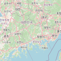
Map view of Hallyeohaesang National Park

Use this park location map to pinpoint Hallyeohaesang National Park in South Korea, understand its exact geographic position, and read its mapped placement within the surrounding landscape more clearly.

Pigeon | © OpenStreetMap contributors

Location context for Hallyeohaesang National Park

Jeollanam-do
Park atlas

Explore an atlas of other protected landscapes across Korea's southern coast and its island archipelago.

Discover National Parks Near Hallyeohaesang, South Korea's Premier Marine Protected Area
Browse a curated list of national parks and protected areas near Hallyeohaesang National Park, tracing similar coastal ecosystems and island landscapes across Korea's southern coast. Compare diverse marine and terrestrial conservation zones, understand regional protected area spread, and map related natural heritage for deeper geographic insight.
National parkSouth Korea

Jirisan National Park: South Korea's Premier Protected Landscape and Map Resource

Explore the mapped terrain and protected area geography.

Jirisan National Park is a key protected area within South Korea, serving as a vital component of the nation's natural landscape. This atlas-focused content provides detailed geographic information, highlighting the park's mapped boundaries and its role within the regional context of the Korean Peninsula. Understand the distinct characteristics of this protected national park for comprehensive geographic discovery.

Area
471.75 km²
Established
1967
IUCN
II
Visitors
1.5M annual
National parkJeollanam-do

Mudeungsan National Park: Mapped Protected Landscape and Regional Geography Context

Explore Mudeungsan National Park's geographic setting in Jeollanam-do.

Mudeungsan National Park offers a distinct protected landscape within the Jeollanam-do region of South Korea. This atlas-focused page details its mapped geographic boundaries and the surrounding natural terrain, providing essential context for understanding its role as a national park. Explore the park's identity through its unique landscape and regional geography.

Area
75.45 km²
Established
2012
IUCN
II
Relief
Mountain
National parkSouth Gyeongsang Province

Gayasan National Park: National Park Identity and Mapped Geographic Context in South Korea

Discover Protected Landscape and Regional Terrain

Gayasan National Park presents a distinct protected-area entity within South Gyeongsang Province, serving as a crucial point for atlas-driven geographic exploration. As a designated national park in South Korea, it offers insights into its specific mapped boundaries and the surrounding natural terrain. Understanding this park's role within the regional geography provides a foundational element for comprehending broader landscape patterns and protected land distribution across the country.

Area
167.6 km²
Established
1972
IUCN
II
Relief
Mountain
National parkJeollanam-do

Wolchulsan National Park: Detailed Geographic and Protected Landscape Atlas Entry

Explore mapped boundaries and natural terrain context.

This MoriAtlas entry for Wolchulsan National Park provides a detailed look at its identity as a protected landscape within Jeollanam-do, South Korea. Focus is placed on its geographic context and mapped park boundaries, offering a foundation for understanding its place in the regional atlas. Discover the structured details of this national park's natural terrain and its significance as a preserved natural area.

Area
56.6 km²
Established
1988
IUCN
II
Relief
Mountain
National parkSouth Korea

Naejangsan National Park: South Korea's Mapped Protected Landscape and Geography

Discover the park's protected boundaries and regional context.

Investigate Naejangsan National Park, a protected area within South Korea, through its mapped geography and landscape context. This detailed atlas entry provides insight into the park's specific geographic identity and its role as a national park, offering a structured understanding of its protected natural features for focused exploration and research.

Area
81.45 km²
Established
1971
IUCN
II
Relief
Mountain
National parkJeollabuk-do

Deogyusan National Park: National Park Identity and Geographic Mapping

Explore its protected land boundaries and regional landscape context.

Examine Deogyusan National Park, a designated national park situated in the Jeollabuk-do region of South Korea. This entry provides critical geographic context, focusing on the park's mapped boundaries and its role as a protected landscape. Users can gain a structured understanding of its natural terrain and regional significance, contributing to a broader atlas of protected areas.

Area
231.65 km²
Established
1975
IUCN
V
Visitors
1M annual
National parkSouth Korea

Dadohaehaesang National Park: Exploring South Korea's Coastal Protected Area Boundaries

Mapped landscape context and regional geography.

Delve into the protected landscape of Dadohaehaesang National Park, a significant national park located in South Korea. This entry provides critical geographic information, detailing the park's mapped boundaries and its place within the broader regional terrain. It serves as an essential resource for understanding the park's protected status and its unique natural features for those exploring national parks and protected areas within an atlas framework.

Area
2,321.5 km²
Established
1981
IUCN
II
Visitors
560K annual
National parkJeollabuk-do

Byeonsan-bando National Park: Protected Landscape and Geographic Context in Jeollabuk-do

Explore mapped terrain and regional park geography.

This detail page provides an in-depth look at Byeonsan-bando National Park, a protected area located in South Korea's Jeollabuk-do region. Users can discover the park's specific geographic identity, understand its mapped boundaries, and explore its role within the broader regional landscape. The content is structured for atlas exploration, offering detailed insights into the park's natural terrain and its significance as a national park.

Area
154.71 km²
Established
1988
IUCN
II
Relief
Mixed relief

Common questions about visiting, size, designation, and location context for Hallyeohaesang National Park

Hallyeohaesang National Park FAQs for park facts, access, geography, and protected area context
Find quick answers about Hallyeohaesang National Park, including protected-area facts, park geography, trail and visitor context, and how the park fits into its surrounding country and regional landscape.
MoriAtlas Explorer

Continue Your Protected Areas Search Across the Global Atlas

Deepen your exploration by continuing the structured search for national parks and protected areas worldwide. Utilize the comprehensive filtering capabilities to compare different conservation landscapes and refine your understanding of global park geography. Discover more about the distribution and characteristics of protected natural areas.

Global natural geography