

Mori Atlas logo
Wildlife reserveRefuge d'oiseaux migrateurs de la Baie-Hannah

Tracing the mapped boundaries of the James Bay intertidal marshes and coastal wetlands

Refuge d'oiseaux migrateurs de la Baie-Hannah: A Protected Coastal Landscape in Ontario

(Hannah Bay Migratory Bird Sanctuary)

Refuge d'oiseaux migrateurs de la Baie-Hannah represents a vital protected corridor along the southern James Bay coast, spanning the boundary region of Ontario. The landscape is characterized by expansive intertidal mudflats and sedge marshes that provide essential staging ground for migratory waterfowl. This federal sanctuary offers a unique look into the Hudson Bay lowlands, documenting how sensitive coastal terrain functions as a critical node in international flyways.

migratory bird sanctuarywetlandsintertidal mudflatscoastal marshessedge marsheswaterfowl staging area

Refuge d'oiseaux migrateurs de la Baie-Hannah

Wildlife reserve

Park overview

Structured park overview, official facts, and landscape profile for Hannah Bay Migratory Bird Sanctuary

Hannah Bay Migratory Bird Sanctuary park facts, protected area profile, and essential visitor context

Review the core facts for Hannah Bay Migratory Bird Sanctuary, including designation, size, terrain, visitor scale, habitats, and operating context in one park-focused overview.

About Hannah Bay Migratory Bird Sanctuary

Hannah Bay Migratory Bird Sanctuary is one of the more ecologically distinctive protected areas in Canada, defined primarily by the interplay between tidal waters, coastal lowlands, and the southern James Bay shoreline. The sanctuary occupies part of the Ministikawatin Peninsula, a low-relief coastal landform that runs along the Ontario, Quebec, and Nunavut interface, ultimately meeting the brackish waters of James Bay. The protected zone captures a transition area where freshwater outflow from the boreal interior meets the marine influence of Hudson Bay, generating nutrient-rich sediments that support one of the most productive intertidal ecosystems in the country.

The sanctuary is firmly embedded in Canada's Migratory Bird Sanctuary network, a series of federal reserves established under the Migratory Birds Convention Act to safeguard critical habitat for migratory species. Created in 1939, Hannah Bay was recognised at an early stage for the importance of its coastal wetlands to waterfowl populations across the continent. Today it continues to be administered by the Canadian Wildlife Service and forms a key node in national monitoring of migratory bird populations, particularly along the Atlantic and Mississippi flyways.

Ecologically, the sanctuary's value lies less in dramatic scenery and more in habitat function. The expansive intertidal mudflats that emerge at low tide expose vast beds of invertebrates, while fringing sedge marshes provide cover, forage, and shelter on adjacent uplands. Together these habitats create an ideal staging environment for waterfowl that need to feed intensively before continuing their migration south, and they support a broader community of shorebirds, raptors, and other wetland-associated species. The inclusion of the sanctuary within the Southern James Bay Ramsar site in 1987 formally linked it to an internationally recognised wetland complex, reinforcing its conservation significance beyond Canadian borders.

Quick facts and research context for Hannah Bay Migratory Bird Sanctuary

Hannah Bay Migratory Bird Sanctuary is located along the southern shore of James Bay, spanning parts of Ontario and Nunavut in northern Canada. Designated in 1939, it is one of the older migratory bird sanctuaries in the Canadian system and is managed by the Canadian Wildlife Service, a branch of Environment and Climate Change Canada. The sanctuary covers roughly 252 square kilometres of coastal wetland and lies within the larger Southern James Bay Ramsar site, recognised internationally in 1987 for its outstanding wetland values.

The protected area forms part of the broader Southern James Bay landscape, which supports millions of migrating birds each year. Its designation under both the Migratory Birds Convention Act and the Ramsar Convention underscores its dual role as a national wildlife sanctuary and an internationally significant wetland.

Protection and recognition

Explore documented protection scope, designation year, and official recognition records.

Refuge d'oiseaux migrateurs de la Baie-Hannah Protection Status and Designation History

Historical protection status records for Refuge d'oiseaux migrateurs de la Baie-Hannah outline the designated framework established in 1987. Official protected area data details the mixed management scope and WDPA identifier for comprehensive geographic reference.

Protection details

Protection scope
Mixed
Designated year
1987
Transboundary protection
No
WDPA ID
19963
Park context

Deeper park guide and search-rich context for Hannah Bay Migratory Bird Sanctuary

Hannah Bay Migratory Bird Sanctuary history, landscape, wildlife, and travel context

Explore Hannah Bay Migratory Bird Sanctuary through its history, landscape character, ecosystems, wildlife, conservation priorities, cultural context, and seasonal travel timing in a structured park guide built for atlas discovery and search intent.

Why Hannah Bay Migratory Bird Sanctuary stands out

Hannah Bay is best known for its enormous autumn gatherings of migratory waterfowl, particularly geese and ducks that stage on the bay's intertidal flats before continuing south. The sanctuary's combination of expansive tidal mudflats and sedge-dominated coastal marshes creates a habitat mosaic that is unusually productive for fattening and resting birds during their fall migration. Species such as the greater snow goose, Canada goose, northern pintail, and American black duck are characteristic of these seasonal concentrations, and the sheer density of birds in the area has made Hannah Bay a long-standing focus of waterfowl research and monitoring in eastern Canada.

Hannah Bay Migratory Bird Sanctuary history and protected-area timeline

Hannah Bay Migratory Bird Sanctuary was formally established in 1939, making it one of the older entries in Canada's national system of migratory bird sanctuaries. Its designation reflected an early recognition, both in Canada and internationally, that the tidal flats and coastal marshes at the southern end of James Bay served as essential habitat for migratory waterfowl. The sanctuary has been administered continuously by the Canadian Wildlife Service, the federal agency responsible for migratory bird conservation in Canada.

In 1987, the sanctuary became part of the larger Southern James Bay Ramsar Wetland of International Importance. This Ramsar listing was a milestone that placed Hannah Bay within a recognised global framework for wetland conservation, alongside neighbouring protected areas along the James Bay and Hudson Bay coasts. The Ramsar designation highlighted the regional importance of the area for migratory waterfowl and underscored the value of the intertidal and marsh habitats that the sanctuary was designed to protect.

Hannah Bay Migratory Bird Sanctuary landscape and geographic character

The landscape of Hannah Bay Migratory Bird Sanctuary is defined by the broad, low-lying coastal zone of southern James Bay. The terrain is shaped by the meeting of land and sea, with extensive intertidal mudflats regularly exposed by the bay's strong tidal cycles. Beyond the tidal zone, the sanctuary includes coastal sedge marshes and low-lying tundra-like shoreline environments typical of the Hudson Bay lowlands.

The Ministikawatin Peninsula provides the broader landform context for the sanctuary, with the protected area running from the Ontario, Quebec border area westward to the bay itself. Vegetation along the coast tends to be sparse and salt-tolerant, reflecting the harsh climate and the influence of brackish water. The result is a wide-open landscape of sky, water, mud, and sedge that may appear austere but is exceptionally productive for the species that depend on it.

Hannah Bay Migratory Bird Sanctuary ecosystems, habitats, and plant life

The ecological character of Hannah Bay Migratory Bird Sanctuary centres on wetland and coastal ecosystems, especially intertidal mudflats and sedge-dominated marshes. These habitats form a transitional zone between freshwater inputs from the boreal interior and the saline influence of James Bay, a dynamic that supports a rich base of invertebrates, plants, and fish that in turn sustain large numbers of birds.

The intertidal flats provide feeding grounds for migratory shorebirds and waterfowl, while the sedge marshes offer cover, nesting habitat, and a buffer against tidal disturbance. Together, these habitat types contribute to one of the most productive wetland complexes in the Canadian subarctic, supporting not only waterfowl but also raptors, shorebirds, and a range of other wetland-dependent wildlife.

Hannah Bay Migratory Bird Sanctuary wildlife and species highlights

Hannah Bay is internationally recognised for its seasonal concentrations of migratory waterfowl, particularly during the autumn staging period when birds gather in large flocks before continuing south. The greater snow goose, Canada goose, northern pintail, and American black duck are among the species most closely associated with the sanctuary. These birds use the intertidal flats and sedge marshes to feed intensively, building energy reserves for their migration.

Beyond waterfowl, the sanctuary also supports shorebirds, raptors that follow the concentrations of prey, and a broader community of wetland-associated birds. The sheer density of birds in the area during fall migration has long drawn the attention of researchers and conservationists, contributing to the sanctuary's enduring importance within Canadian wildlife monitoring efforts.

Hannah Bay Migratory Bird Sanctuary conservation status and protection priorities

Hannah Bay Migratory Bird Sanctuary is protected under Canada's Migratory Birds Convention Act and is managed by the Canadian Wildlife Service, giving it a strong federal protection framework. Its inclusion within the Southern James Bay Ramsar site in 1987 placed it within an internationally recognised network of wetlands of global importance, reinforcing its conservation status on a broader scale.

The sanctuary's conservation value is tied to the function of its tidal flats and marshes as essential habitat for migratory species, particularly waterfowl that depend on coastal wetlands across the Hudson Bay and James Bay flyways. By safeguarding these habitats from disturbance and degradation, the sanctuary contributes to the long-term resilience of migratory bird populations that travel between Arctic breeding areas and southern wintering grounds.

Top sights and standout views in Hannah Bay Migratory Bird Sanctuary

The sanctuary's defining quality is the combination of vast intertidal mudflats and sedge marshes that produce dramatic seasonal concentrations of migratory waterfowl. Its location along the southern James Bay coast, at the meeting point of Ontario and Nunavut, gives it both a remote character and a central role within one of Canada's most important coastal wetland complexes. The sanctuary's long-standing federal protection since 1939 and its inclusion in a Ramsar Wetland of International Importance add depth to its conservation profile.

Best time to visit Hannah Bay Migratory Bird Sanctuary

The most ecologically meaningful period at Hannah Bay is autumn, when migratory waterfowl concentrate on the tidal flats and marshes to feed and rest before continuing southward. During this season, the sanctuary hosts some of the largest gatherings of geese and ducks in eastern Canada, including greater snow geese, Canada geese, northern pintails, and American black ducks. Spring and summer bring different but smaller bird communities, while winter conditions in this subarctic coastal region are harsh and generally unsuitable for casual visitation. Because the sanctuary is remote and ecologically sensitive, any actual visit would depend on weather, access, and conservation considerations rather than routine tourism.

Monthly climate preview

Long-term representative monthly temperature and precipitation data for Ontario protected geography

Refuge d'oiseaux migrateurs de la Baie-Hannah Climate Normals and Annual Weather Patterns

Refuge d'oiseaux migrateurs de la Baie-Hannah exhibits severe sub-zero winter means alongside moderate summer warmth in measured multi-decade coordinate records. Examining the complete monthly climatology profile provides precise insight into long-term temperature swings and precipitation distribution across the year.
Annual mean-1 °C
-17 °C13 °C
Jan-17°
Feb-16°
Mar-11°
Apr-3°
May
Jun
Jul13°
Aug13°
Sep10°
Oct
Nov-3°
Dec-12°
Warmest month
August

12.7 °C

Coolest month
January

-17.4 °C

Wettest month
September

3.3 mm/day

Driest month
February

1 mm/day

Park location guide

Geography guide, regional context, and park location map for Hannah Bay Migratory Bird Sanctuary

Hannah Bay Migratory Bird Sanctuary park geography, regions, and map view in Canada

Understand where Hannah Bay Migratory Bird Sanctuary sits in Canada through a broader geographic reading of the surrounding landscape, nearby location context, and its mapped position within the national park landscape.

How Hannah Bay Migratory Bird Sanctuary fits into Canada

Canada is a federal parliamentary constitutional monarchy spanning North America from the Atlantic to the Pacific and Arctic Oceans. With a population of over 41 million, it is officially bilingual in English and French at the federal level. The country gained independence from the United Kingdom through a gradual process culminating in 1982.

Wider geography shaping Hannah Bay Migratory Bird Sanctuary in Canada

Canada occupies the northern portion of North America, sharing its longest international border with the United States. The country extends from the Atlantic Ocean to the Pacific Ocean and northward into the Arctic Ocean, giving it the longest coastline of any nation.

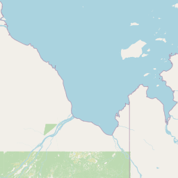
Map view of Hannah Bay Migratory Bird Sanctuary

Use this park location map to pinpoint Hannah Bay Migratory Bird Sanctuary in Canada, understand its exact geographic position, and read its mapped placement within the surrounding landscape more clearly.

Pigeon | © OpenStreetMap contributors

Location context for Hannah Bay Migratory Bird Sanctuary

NunavutOntario
Recorded earthquake history

View Recorded Seismic Activity Near Refuge d'oiseaux migrateurs de la Baie-Hannah

Examine the historical record of earthquakes documented within the vicinity of Refuge d'oiseaux migrateurs de la Baie-Hannah. This MoriAtlas catalogue details timing and magnitude for regional seismic events, providing geographic context for the protected landscape along the James Bay coast.

Refuge d'oiseaux migrateurs de la Baie-Hannah Earthquake History

Catalogued events

1 event

Strongest magnitude

Magnitude 4.1

Most recent event

Nov 15, 2025

This history includes earthquakes recorded inside the park or within 50 km of its borders

Park atlas

Compare regional wetland reserves and neighboring coastal sanctuaries across northern boundaries

Parks Near Refuge d'oiseaux migrateurs de la Baie-Hannah and Surrounding Protected Landscapes

Browse nearby protected areas and related coastal habitats extending across the surrounding James Bay lowlands. Continued exploration reveals connected wetland networks and comparable northern sanctuaries within the regional geography.
Wildlife reserveQuebec
56 km away#1 closest

Northeast

Refuge d'oiseaux migrateurs de la Baie-Boatswain: Coastal Wildlife Reserve and Habitat

Geographic overview of subarctic estuarine protected landscapes

Situated along the remote James Bay coast in Quebec, this sanctuary protects expansive tidal flats and shallow coastal waters. The reserve functions as an integral stopover for migratory geese moving between southern wintering areas and the Arctic. Its unique landscape of rocky reefs, sheltered embayments, and subarctic transition terrain makes it a vital node for regional conservation and waterfowl study.

Area
163.52 km²
Established
1941
IUCN
Ia
National parkThunder Bay District
524 km away#2 closest

Southwest

Pukaskwa National Park National Park: Explore Its Protected Landscape and Geographic Identity

Discover the mapped boundaries and regional atlas context.

Pukaskwa National Park represents a key protected area, offering critical insights into the regional geography of Thunder Bay District. As a national park, its mapped boundaries and unique landscape identity are central to understanding Canada's protected lands. This entry provides the foundational geographic context for exploring Pukaskwa National Park within a structured atlas framework, detailing its place among other natural landscapes.

Area
1,878 km²
Established
1978
IUCN
II
Visitors
17.3K annual
A watercolor painting of a rolling, soft-toned landscape with a foreground of green forest and layers of hills receding into the distance.
Protected landscapeUpper Peninsula of Michigan
641 km away#3 closest

Southwest

Hiawatha National Forest: Geographic Overview and Protected Area Map of the Upper Peninsula

Coastal forest landscape and wilderness river corridors.

Hiawatha National Forest spans significant portions of the Upper Peninsula of Michigan, bridging the gap between northern hardwood forests and the boreal environments of the Great Lakes. This protected landscape encompasses extensive shorelines along Lake Superior, Lake Michigan, and Lake Huron, alongside six wilderness areas and five designated wild and scenic rivers.

Area
3,621.27 km²
Established
1931
IUCN
VI
Relief
Lowland
Marine protected areaMichigan
668 km away#4 closest

South

Thunder Bay National Marine Sanctuary: Geography and Protected Maritime Landscape Context

Mapping underwater heritage in the Michigan Great Lakes region

Spanning 4,300 square miles of Lake Huron, Thunder Bay National Marine Sanctuary preserves a significant collection of shipwrecks within a glacially shaped freshwater terrain. This marine protected area offers a look at submerged geography ranging from shallow coastal bays to deep lake basins. It serves as a vital anchor for understanding maritime history and freshwater ecosystem stability across the Michigan shoreline.

Area
11,000 km²
Established
2000
Relief
Lowland
Climate
Temperate
National parkQuebec
676 km away#5 closest

Southeast

La Mauricie National Park: Quebec National Park Atlas and Protected Landscape

Explore its mapped boundaries and natural terrain.

Delve into the protected landscape of La Mauricie National Park, a key national park situated within Quebec's diverse geography. This destination provides detailed insights into the park's mapped boundaries and its unique natural terrain, offering a structured approach to understanding protected areas and regional landscapes. It serves as an essential point for exploring the park's geographic identity and its place within the Canadian conservation atlas.

Area
536 km²
Established
1970
IUCN
II
Visitors
278.9K annual
National parkOntario
681 km away#6 closest

South

Bruce Peninsula National Park: National Park Protected Landscape and Geographic Context in Ontario

Discover its mapped boundaries and regional landscape identity.

Bruce Peninsula National Park stands as a protected national park entity within Ontario, offering a distinct geographic profile. Its mapped boundaries and position within the regional atlas are crucial for understanding its landscape character. MoriAtlas facilitates exploration of the park's protected status and its contribution to the conservation landscape of Ontario.

Area
154 km²
Established
1987
IUCN
II
Visitors
460.4K annual
Wildlife reserveMichigan
684 km away#7 closest

Southwest

Mackinac Wilderness Protected Area: Glacial Terrain and River Geography in Upper Michigan

A roadless wilderness reserve within Hiawatha National Forest

Uncover the geographic significance of Mackinac Wilderness, an IUCN Category Ib protected area in Michigan. The unit provides a distinct look at northern forest recovery through a terrain of sandy ridges, aspen and birch cover, and aquatic corridors. This study examines the interplay between postglacial landforms and the ongoing natural succession occurring along the Carp River drainage basin.

Area
49.5 km²
IUCN
Ib
Relief
Lowland
Climate
Temperate
National parkOntario
685 km away#8 closest

South

Georgian Bay Islands National Park: Ontario National Park Protected Landscape Atlas

Explore mapped boundaries and regional geographic context.

Gain a comprehensive understanding of Georgian Bay Islands National Park as a distinct protected area within Ontario. This entry provides detailed geographic context, focusing on the park's mapped landscape, its protected status as a national park, and its position within the regional geography of Canada. It is designed for users seeking structured information about protected lands and their atlas-level significance.

Area
13.5 km²
Established
1929
IUCN
II
Visitors
27.5K annual

Common questions about visiting, size, designation, and location context for Hannah Bay Migratory Bird Sanctuary

Hannah Bay Migratory Bird Sanctuary FAQs for park facts, access, geography, and protected area context

Find quick answers about Hannah Bay Migratory Bird Sanctuary, including protected-area facts, park geography, trail and visitor context, and how the park fits into its surrounding country and regional landscape.
MoriAtlas Explorer

Continue Your Protected Areas Search Across the Global Atlas

Deepen your exploration by continuing the structured search for national parks and protected areas worldwide. Utilize the comprehensive filtering capabilities to compare different conservation landscapes and refine your understanding of global park geography. Discover more about the distribution and characteristics of protected natural areas.

Global natural geography
