

Mori Atlas logo
National parkHimchari National Park

Discover the mapped boundaries and regional context of this protected natural area in Bangladesh.

Himchari National Park: Bangladesh's Protected National Park Landscape and Geography

Himchari National Park stands as a significant protected natural area within Bangladesh, offering a distinct landscape for geographic exploration. Situated in a region shaped by the Ganges-Brahmaputra delta, this national park provides context for understanding the protected land distribution and natural terrain of South Asia. Its identity as a national park underscores its importance for atlas-style discovery and appreciating the mapped features of Bangladesh's conservation landscapes.

National ParkHill ForestCoastal EcosystemEvergreen ForestBangladeshSouth Asia

Himchari National Park

National park

Park overview

Structured park overview, official facts, and landscape profile for Himchari National Park

Himchari National Park park facts, protected area profile, and essential visitor context
Review the core facts for Himchari National Park, including designation, size, terrain, visitor scale, habitats, and operating context in one park-focused overview.

About Himchari National Park

Himchari National Park occupies a distinctive ecological niche within Bangladesh's protected area network as one of the few locations where hilly terrain meets coastal waters. The park's location in the southeastern part of the country places it within a region of significant topographical variation, as the relatively flat coastal plain gives way to the forested hills that characterize this protected area. The mixed evergreen forest that dominates the park contains significant botanical diversity, with approximately 117 tree species from 37 families recorded within the boundaries. The park's proximity to the Bay of Bengal influences its microclimate and creates conditions for a blend of terrestrial and maritime ecosystems to coexist in close proximity. Adjacent to the town of Cox's Bazar, the park serves as both a conservation area and a recreational resource for visitors drawn to its combination of forest scenery and coastal setting. The protected status granted in 1980 reflects recognition of the area's ecological value at a time when Bangladesh was expanding its national park system to preserve representative samples of the country's diverse habitats.

Quick facts and research context for Himchari National Park

Himchari National Park is located in Cox's Bazar District in southeastern Bangladesh, approximately 10 kilometers from Cox's Bazar town. The park encompasses 1,729 hectares of mixed evergreen forest covering a series of hills that run parallel to the coast before meeting the Bay of Bengal. The area is administered by the Cox's Bazar South Forest Division, with management distributed across four forest beats: Kolatoli, Chainda, Jhilongja, and Link Road. The park was established as a protected area in 1980 and is classified under IUCN Category IV, reflecting its role in habitat and species conservation.

Park context

Deeper park guide and search-rich context for Himchari National Park

Himchari National Park history, landscape, wildlife, and travel context
Explore Himchari National Park through its history, landscape character, ecosystems, wildlife, conservation priorities, cultural context, and seasonal travel timing in a structured park guide built for atlas discovery and search intent.

Why Himchari National Park stands out

Himchari National Park is best known for its distinctive broken hills landscape, where a series of eroded and fragmented hillocks create a striking visual terrain unlike typical Bangladesh geography. The park's row of Christmas trees has become an iconic feature visible in photographs of the area. The protected area is significant for its primate populations, particularly the Hoolock gibbon, which represents one of Bangladesh's few remaining ape species in the wild. The park also protects one of the few coastal hill forest ecosystems in the country, where evergreen forest descends directly to meet the marine environment of the Bay of Bengal.

Himchari National Park history and protected-area timeline

Himchari National Park was established on February 15, 1980, as part of Bangladesh's growing commitment to biodiversity conservation during the late twentieth century. The designation came at a time when the country was systematically identifying and protecting significant natural areas that represented its ecological diversity. The park was classified under IUCN Category IV, which designates protected areas focused on habitat and species management rather than strict wilderness preservation or cultural landscape protection. The choice of Category IV reflected the park's characteristics as a managed forest ecosystem with ongoing human presence and the need for active conservation interventions. Following establishment, the park fell under the jurisdiction of the Cox's Bazar South Forest Division, which continues to manage the protected area through its network of forest beats. The park's establishment also coincided with broader regional development in Cox's Bazar, where tourism infrastructure was expanding and the area's natural attractions were increasingly recognized as assets worth protecting.

Himchari National Park landscape and geographic character

The landscape of Himchari National Park is defined by a series of hills that rise from the coastal plain and descend toward the Bay of Bengal. These hills, often described as broken hills, present an eroded and fragmented topography that creates a distinctive visual character unique among Bangladesh's protected areas. The hill terrain is covered in dense evergreen forest that blankets the slopes and valleys between the hillocks. The forest floor features dense undergrowth typical of tropical evergreen systems, making walking through the park challenging even on established trails. The park's western boundary meets the waters of the Bay of Bengal, where the forest-covered hills descend directly to the beach zone without an intermediate coastal plain. This configuration creates dramatic views where verdant forest meets the sea. The Kolatoli, Chainda, Jhilongja, and Link Road forest beats represent different sections of this hilly terrain, each with slightly different character and accessibility.

Himchari National Park ecosystems, habitats, and plant life

The ecological character of Himchari National Park is defined by its mixed evergreen forest ecosystem, which represents a habitat type that is limited in Bangladesh. The forest contains approximately 117 tree species belonging to 37 families, creating a complex and layered vegetation structure. Several plant species recorded in the park are considered near-endangered, including Elaeis guineensis, Garcinia lanceifolia, Elaeocarpus tectorius, Elaeocarpus floribundus, Suregada multiflora, Lithocarpus elegans, and Acronychia pedunculata. This botanical diversity supports a correspondingly diverse animal community. The park's location at the boundary between terrestrial forest and coastal marine environments creates ecological conditions that support species from both habitats. The evergreen forest provides continuous canopy cover throughout the year, supporting species that depend on stable forest conditions. The combination of hill forest and coastal access creates a mosaic of habitats within a relatively compact protected area.

Himchari National Park wildlife and species highlights

Himchari National Park supports notable wildlife diversity with 286 bird species, 26 mammal species, and sea turtle populations recorded within its boundaries. The mammal community includes several species of significant conservation concern. The Hoolock gibbon represents the only ape species found in Bangladesh, and Himchari provides important habitat for this primate. Predators present in the park include the tiger, Asian black bear, and sloth bear, reflecting the area's role as one of the few locations in Bangladesh where large carnivores persist. Smaller carnivores include the leopard cat and fishing cat, both species adapted to forest environments. The Asian elephant population represents a remnant of larger herds that historically ranged through the region. Other mammals include the wild boar, Rhesus macaque, and various mongoose species. Birdlife is particularly diverse, with species such as the barn swallow and Asian palm swift commonly observed. The park also serves as habitat for the Ridley sea turtle, a marine species that uses coastal beaches for nesting.

Himchari National Park conservation status and protection priorities

Himchari National Park faces several conservation challenges despite its protected status. The park contains approximately 4,000 people living within its boundaries, primarily migrants engaged in fishing and cultivation. This human presence creates ongoing pressure on the forest ecosystem through activities such as fuel wood collection, minor forest produce extraction, and agricultural encroachment. Invasive weed species threaten the native plant community, while cattle grazing impacts forest regeneration. Infrastructure development, including road expansion projects, fragments habitat and creates edge effects that penetrate into the core protected area. Fire hazards add another layer of risk to the forest ecosystem. The loss of tree diversity and population represents a measurable conservation concern, with the combination of threats potentially altering the park's ecological character over time. Conservation management focuses on balancing the needs of local communities with the imperative to protect the park's biodiversity values.

Himchari National Park cultural meaning and human context

The human dimension of Himchari National Park includes approximately 4,000 residents living within the protected area boundaries. These inhabitants are primarily migrants who have settled in the area, with their livelihoods centered on fishing and cultivation. The presence of human communities within a formally designated national park creates complex management considerations, as conservation objectives must be balanced with community needs. The park's location near Cox's Bazar, Bangladesh's primary seaside tourist destination, means that the protected area experiences visitor pressure from tourism activities in addition to the pressures from resident communities. The relationship between the park's natural resources and local livelihoods represents a recurring theme in the park's management and conservation planning.

Top sights and standout views in Himchari National Park

Himchari National Park stands out for its distinctive broken hills landscape, a rare topographical feature in Bangladesh's generally flat terrain. The park protects significant primate populations including the Hoolock gibbon, Bangladesh's only ape species. The combination of hill forest and coastal shoreline creates a unique ecosystem where evergreen forest meets the Bay of Bengal. The iconic row of Christmas trees has become synonymous with the park's visual identity. Notable mammal species including tigers, Asian elephants, Asian black bears, and sloth bears persist in the forest. The area supports 286 bird species and serves as nesting habitat for Ridley sea turtles. The park represents one of Bangladesh's most ecologically diverse protected areas, combining multiple habitat types within a relatively compact area.

Best time to visit Himchari National Park

The optimal period for visiting Himchari National Park falls during the dry season from November through March, when rainfall is minimal and trail conditions are most favorable for forest exploration. During these months, the park's evergreen forest remains lush while visibility along trails improves and the hilly terrain becomes more accessible. The winter months may offer opportunities to observe certain bird species that are more active during cooler periods. The park can be visited year-round, though the monsoon season from June to September brings heavy rainfall that makes trail navigation difficult and increases the risk of landslides on the hill slopes. Summer months from April to May feature high temperatures and humidity that can make physical activity in the forest challenging. Visitors interested in wildlife viewing should note that animal activity patterns are influenced by temperature and rainfall, with early morning and late afternoon periods generally offering the best observation opportunities.

Park location guide

Geography guide, regional context, and park location map for Himchari National Park

Himchari National Park park geography, regions, and map view in Bangladesh
Understand where Himchari National Park sits in Bangladesh through a broader geographic reading of the surrounding landscape, nearby location context, and its mapped position within the national park landscape.

How Himchari National Park fits into Bangladesh

Bangladesh, officially the People's Republic of Bangladesh, is a South Asian country known for its high population density and deltaic geography formed by the Ganges-Brahmaputra river system. It gained independence from Pakistan in 1971 following a liberation war. The country operates as a unitary parliamentary republic with Dhaka as its capital and largest city, while Chittagong serves as the second-largest city and main port.

Wider geography shaping Himchari National Park in Bangladesh

Bangladesh occupies the delta region at the confluence of the Ganges, Brahmaputra, and Meghna rivers in South Asia. The country shares land borders with India to the north, west, and east, and Myanmar to the southeast, while its southern boundary is along the Bay of Bengal. The terrain is predominantly low-lying deltaic plain, making it susceptible to flooding. The country is separated from Bhutan and Nepal by the Siliguri Corridor and from China by the Indian state of Sikkim.

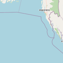
Map view of Himchari National Park

Use this park location map to pinpoint Himchari National Park in Bangladesh, understand its exact geographic position, and read its mapped placement within the surrounding landscape more clearly.

Pigeon | © OpenStreetMap contributors

Location context for Himchari National Park

Cox's Bazar District
Park atlas

Compare Bangladesh's national parks, tracing the regional spread of hill forests and coastal ecosystems.

Discover Related Protected Areas Near Himchari National Park
Browse national parks and protected areas geographically near Himchari National Park, exploring Bangladesh's unique landscapes of hill forests, coastal ecosystems, and significant wildlife habitats. Compare these protected landscapes for a broader atlas view, understanding regional conservation efforts and mapping similar ecological features across South Asia.
National parkCox's Bazar District

Medhakachhapia National Park: Protected Mangrove Landscape and Geography in Cox's Bazar

Mapping the boundaries of a unique coastal Bangladesh National Park.

Medhakachhapia National Park is a distinct protected area in Cox's Bazar District, Bangladesh, renowned for its old-growth Rhizophora apiculata mangrove forest. Spanning approximately 396 hectares, it serves as a crucial habitat and represents a specific type of tropical coastal landscape. This park's designation as a national park highlights its conservation importance, particularly its role in protecting some of Bangladesh's most mature mangrove stands. Explore its geographic context and protected status for a deeper understanding of its natural landscape.

Area
3.959 km²
Established
2008
IUCN
IV
Relief
Lowland
National parkRangamati District

Kaptai National Park: Protected Landscape and Geographic Context in Rangamati District

Explore its mixed evergreen forest and lakeside terrain.

Kaptai National Park is a crucial protected area located in Bangladesh's Rangamati District, renowned for its mixed evergreen forests and unique position adjacent to Kaptai Lake. This detail page provides an atlas-oriented perspective on the park's geographic identity, mapped boundaries, and its role within the diverse Chittagong Hill Tracts region. Understand the terrain, from rolling hills to lakeside environments, and appreciate its conservation significance as a national park.

Area
54.64 km²
Established
1999
IUCN
II
Climate
Subtropical
National parkBangladesh

Nijhum Dweep National Park: A Protected Landscape in Bangladesh's Geographic Atlas

Explore the mapped boundaries and regional setting of this national park.

Nijhum Dweep National Park is a key protected area situated within the deltaic geography of Bangladesh. This detailed entry provides insight into its mapped landscape, natural terrain, and its significance as a national park. Understand its geographic context and explore its protected boundaries as part of a broader atlas of natural areas, offering a factual basis for understanding this unique South Asian landscape.

Area
163.52 km²
Established
2001
IUCN
IV
Relief
Lowland
National parkChittagong District

Baroiyadhala National Park: A Vital Wildlife Corridor and Protected Forest Landscape in Bangladesh

Discover its terrain, mapped boundaries, and regional significance.

Baroiyadhala National Park, situated in Bangladesh's Chittagong District, stands as a critical national park dedicated to preserving forest ecosystems and functioning as an essential wildlife corridor. The park's undulating terrain and dense vegetation are vital for supporting threatened species and maintaining habitat connectivity. This page offers an atlas-style exploration of Baroiyadhala National Park, detailing its protected area status, geographic context within the Chittagong region, and its significance for conservation in South Asia, providing a rich understanding of its natural landscape.

Area
29.34 km²
Established
2010
IUCN
II
Climate
Tropical
National parkIndia

Phawngpui National Park: An Indian National Park's Protected Landscape and Geography

Explore its mapped boundaries and regional natural terrain.

Phawngpui National Park stands as a distinct protected area within India, contributing significantly to the nation's atlas of natural landscapes. Its designation as a national park underscores its importance for understanding regional geography and mapped terrain. This profile focuses on the park's specific protected-area identity and its role in the broader geographic context of India, offering clear insights for landscape and park map discovery.

Area
50 km²
Established
1992
IUCN
II
Visitors
469 annual
National parkChin State

Natmataung National Park: Protected Mountain Landscape and Biodiversity Atlas in Chin State

Explore the mapped terrain and elevational gradients of Mount Victoria.

Natmataung National Park, located in Chin State, Myanmar, offers a profound encounter with dramatic mountainous terrain and exceptional biodiversity. As a protected national park, it safeguards Mount Victoria, the highest peak in the region, and a remarkable ecological gradient spanning diverse forest types. This page provides an atlas-focused view of its geography, highlighting the steep ridgelines, deep valleys, and unique habitats that define this significant protected landscape and its role in watershed protection.

Area
723 km²
Established
2010
IUCN
II
Relief
Mountain
National parkPatuakhali District

Kuakata National Park: Protected Landscape Identity and Geographic Atlas

Mapped boundaries and regional context within Patuakhali District.

Kuakata National Park is a significant protected area designated as a national park, offering valuable insights into the geography of Patuakhali District. This park detail page provides a structured exploration of its mapped boundaries and protected landscape characteristics, serving as a vital entry point for understanding its place within the larger atlas of global natural sites. Focus on its specific geographic setting and conservation status for detailed discovery.

Area
16.13 km²
Established
2010
IUCN
II
Relief
Lowland
National parkTripura

Clouded Leopard National Park: National Park Protected Area in Tripura's Forested Landscape

Mapped primate habitat and regional geography in Northeast India.

Clouded Leopard National Park serves as a critical protected area within Tripura, India, focusing on the conservation of its forest ecosystems and primate populations, including the Phayre's langur. As part of the larger Sepahijala Wildlife Sanctuary, its mapped boundaries contribute to the regional protected landscape. This national park offers valuable insight into the natural terrain and biodiversity specific to Northeast India, providing a unique geographic focus for atlas exploration.

Area
5.08 km²
Established
2007
IUCN
II
Climate
Tropical

Common questions about visiting, size, designation, and location context for Himchari National Park

Himchari National Park FAQs for park facts, access, geography, and protected area context
Find quick answers about Himchari National Park, including protected-area facts, park geography, trail and visitor context, and how the park fits into its surrounding country and regional landscape.
MoriAtlas Explorer

Continue Your Protected Areas Search Across the Global Atlas

Deepen your exploration by continuing the structured search for national parks and protected areas worldwide. Utilize the comprehensive filtering capabilities to compare different conservation landscapes and refine your understanding of global park geography. Discover more about the distribution and characteristics of protected natural areas.

Global natural geography
Himchari National Park: Bangladesh National Park Map and Protected Area
