Mori Atlas logo
National parkHuerquehue National Park

Explore the mapped boundaries and ancient araucaria forests of this national park.

Huerquehue National Park: Protected Landscape and Andean Geography in La Araucanía

Huerquehue National Park represents a significant protected area within the rugged Andean foothills of Chile's La Araucanía Region. This national park encompasses a distinctive landscape characterized by ancient araucaria forests, numerous clear glacial lakes, and mountainous terrain rising to 2,000 meters. Its identity as a protected landscape is deeply intertwined with the Valdivian temperate rainforest ecosystem, offering a unique window into southern Chile's natural geography and park boundaries for atlas-driven exploration.

Temperate RainforestAraucaria ForestsAndean FoothillsGlacial LakesMountain ParksSouthern Chile

Huerquehue National Park

National park

Park overview

Structured park overview, official facts, and landscape profile for Huerquehue National Park

Huerquehue National Park park facts, protected area profile, and essential visitor context

Review the core facts for Huerquehue National Park, including designation, size, terrain, visitor scale, habitats, and operating context in one park-focused overview.

About Huerquehue National Park

Huerquehue National Park protects a significant portion of the Andean-Patagonian forest ecosystem within Chile's La Araucanía Region. The park's location in the foothills of the Andes places it at the intersection of multiple ecological zones, creating a diverse landscape of mountainous terrain, dense forests, and freshwater bodies. The area east of Caburgua Lake features dramatic topography with elevation gains of nearly 1,300 meters, supporting distinct ecological communities from lower-elevation deciduous forests to higher-altitude mixed forests. The park's 20 documented water bodies, including lakes such as Tinquilco, Verde, and numerous smaller lagoons, contribute to its ecological significance and visual appeal. These aquatic features belong to the Toltén River hydrographic basin, with the Renahue Blanco and Quinchol rivers serving as the primary water courses.

Quick facts and research context for Huerquehue National Park

Huerquehue National Park spans 125 square kilometers in the La Araucanía Region of southern Chile, located approximately 145 kilometers southeast of Temuco and 33 kilometers east of Pucón. The park was officially established on June 9, 1967, though its protected origins trace back to 1912 when the area was part of a much larger Benjamín Vicuña Mackenna Park. The name derives from Mapudungun, the language of the local Mapuche people, meaning 'the messenger's place.' The park features an elevation range from 720 to 2,000 meters and experiences a temperate climate with annual rainfall of approximately 2,045 millimeters.

Protection and recognition

Exploring documented management scope and official land protection boundaries

Huerquehue National Park Protection Status and Terrestrial Conservation Designations

National park enthusiasts can examine the documented protection status and terrestrial conservation scope established for Huerquehue National Park. Understanding official management frameworks and designated boundaries provides essential geographic context for studying protected Andean habitats.

Protection details

Protection scope
Terrestrial
Transboundary protection
No
Park context

Deeper park guide and search-rich context for Huerquehue National Park

Huerquehue National Park history, landscape, wildlife, and travel context

Explore Huerquehue National Park through its history, landscape character, ecosystems, wildlife, conservation priorities, cultural context, and seasonal travel timing in a structured park guide built for atlas discovery and search intent.

Why Huerquehue National Park stands out

Huerquehue National Park is best known for its ancient araucaria forests, featuring the iconic monkey puzzle tree (Araucaria araucana), a species currently classified as vulnerable. The park's landscape is distinguished by numerous clear lakes and lagoons, with Tinquilco Lake being among the most prominent. The combination of these ancient conifer forests with the park's glacial lakes creates a distinctive visual identity that sets it apart within Chile's national park system. The area represents one of the finest examples of Andean-Patagonian forest in the Araucanía Mountain range.

Huerquehue National Park history and protected-area timeline

The national park was officially created on June 9, 1967, with the primary purpose of protecting the area's unique forest ecosystems and landscapes. However, the protected status of this territory traces back much further, to 1912 when the Chilean government established the Benjamín Vicuña Mackenna Park, also known as Colico, which originally encompassed an extensive 265,000 hectares. Over time, this larger protected area was subdivided into the various parks and reserves that exist today, with Huerquehue National Park representing a significant remnant of the original protection effort. The park is administered by the Corporación Nacional Forestal (CONAF), Chile's national forest corporation, which manages the protected area's conservation and visitor services.

Huerquehue National Park landscape and geographic character

The park's landscape is characterized by mountainous terrain with steep slopes and deep valleys carved by glacial activity, typical of the Andean foothills in southern Chile. The terrain rises from around 720 meters near the lower lakes to approximately 2,000 meters at the higher elevations, creating diverse microclimates and habitat zones. The landscape features numerous glacial lakes and lagoons scattered throughout the forest, with the most significant being Tinquilco Lake in the lower portion of the park. Smaller bodies of water, including ponds named Los Patos, Huerquehue, Escondida, Seca, Clara, Las Avutardas, Angelina, and Los Cóndores, add to the aquatic character of the area. The ancient araucaria trees dominate the forest canopy, creating a distinctive visual environment with their unusual symmetrical branching patterns and stiff, evergreen leaves.

Huerquehue National Park ecosystems, habitats, and plant life

Huerquehue National Park lies within the Valdivia temperate rainforest ecoregion, specifically within the Andean-Patagonian forest sub-region known as the Araucanía Mountain range. The forest ecosystem here is classified as Andean deciduous forest, with two distinct sub-communities: High-Andean deciduous forests dominated by araucaria, and mixed Andean deciduous forests at lower elevations. The araucaria (Araucaria araucana) represents the most notable botanical feature, an ancient conifer species considered vulnerable due to past logging and habitat fragmentation. The park also contains significant biodiversity in its aquatic environments, with 20 documented water bodies supporting various wetland ecosystems.

Huerquehue National Park wildlife and species highlights

The park protects several notable mammal species, including the kodkod (Leopardus guigna), Chile's smallest wild cat and an endangered species, and the pudú (Pudú puda), recognized as the world's smallest deer and classified as vulnerable. The culpeo or Andean fox (Lycalopex culpaea) roams the park's forests, while the long-clawed mole mouse (Geoxus valdivianus) represents a rare small mammal. The avian community includes the endangered peregrine falcon, vulnerable species such as the Chilean pigeon and Magellanic woodpecker, and the impressive Andean condor. Wetland areas support black-necked swans, and the forests are home to the slender-billed parakeet. The park also protects Darwin's frog, a vulnerable amphibian species known for its unusual breeding behavior.

Huerquehue National Park conservation status and protection priorities

Huerquehue National Park plays a critical role in protecting the remaining stands of ancient araucaria forest in Chile, a species that has been significantly reduced by historical logging and land conversion. The park's inclusion in Chile's national park system provides legal protection for endangered species including the kodkod and pudú, as well as vulnerable bird species. The protected area serves as a buffer against habitat fragmentation in the Andean foothills, connecting with adjacent reserves to form a larger conservation landscape. The park's management by CONAF focuses on maintaining the integrity of the temperate rainforest ecosystem while providing controlled recreational access.

Huerquehue National Park cultural meaning and human context

The park's name derives from Mapudungun, the language of the Mapuche people who have inhabited the La Araucanía Region for centuries. The name 'Huerquehue' translates to 'the messenger's place,' reflecting the historical significance of this territory within Mapuche culture. The broader region maintains strong connections to Mapuche heritage, and the park sits within traditional Mapuche lands. Understanding this cultural context adds depth to the park's identity, connecting the natural landscape to the human history of the region.

Top sights and standout views in Huerquehue National Park

The ancient araucaria forests of Huerquehue National Park represent one of the most distinctive and photographed landscapes in Chile's southern park system. The Three Lakes Hiking Trail offers visitors the opportunity to experience the park's forest and lake environments, while the clear waters of Tinquilco Lake provide a striking focal point for the landscape. The diversity of wildlife, from the endangered kodkod to the vulnerable pudú and the iconic Andean condor, adds ecological significance to the park's visual beauty. The elevation range from 720 to 2,000 meters creates diverse habitats within a relatively compact area, allowing visitors to experience multiple forest types during a single visit.

Best time to visit Huerquehue National Park

The park can be visited year-round, though the experience varies significantly between seasons. Summer months offer warmer temperatures and easier access to higher-elevation trails, making this the most popular time for hiking and camping. The winter months bring cold temperatures and icy conditions at higher elevations due to the park's altitude. The wettest period occurs from May through September, with annual rainfall reaching approximately 2,045 millimeters, creating lush forest conditions but potentially challenging trail conditions. The best general visiting window falls during the Chilean summer (December to March) when trails are most accessible and the araucaria forests are at their most visually striking against clear skies.

Monthly climate preview

Long term temperature and precipitation trends mapped at 795 meters in La Araucania

Huerquehue National Park Climate Normals and Monthly Weather Patterns

Long-term records at the representative coordinate show mild summers with low precipitation alongside colder, wetter winters where average minimum temperatures drop below freezing. Exploring the full monthly dataset reveals the precise transition between dry periods and high-precipitation intervals across the La Araucania terrain.
Annual mean9 °C
3 °C15 °C
Jan15°
Feb15°
Mar13°
Apr
May
Jun
Jul
Aug
Sep
Oct
Nov10°
Dec13°
Warmest month
February

14.9 °C

Coolest month
July

3.3 °C

Wettest month
June

7 mm/day

Driest month
January

0.9 mm/day

Park location guide

Geography guide, regional context, and park location map for Huerquehue National Park

Huerquehue National Park park geography, regions, and map view in Chile

Understand where Huerquehue National Park sits in Chile through a broader geographic reading of the surrounding landscape, nearby location context, and its mapped position within the national park landscape.

How Huerquehue National Park fits into Chile

Chile is a presidential republic in western South America, extending as a narrow strip along the western edge of the continent between the Andes Mountains and the Pacific Ocean. It is the southernmost country in the world and the closest to Antarctica. The country is bordered by Peru, Bolivia, and Argentina, and administers several Pacific islands including Easter Island. Chile is a major copper producer and has a population of approximately 19.6 million.

Wider geography shaping Huerquehue National Park in Chile

Chile occupies a narrow strip of land along the western edge of South America, extending approximately 4,300 km north to south but only about 350 km east to west at its widest point. The country is sandwiched between the Andes Mountains to the east and the Pacific Ocean to the west. It shares borders with Peru to the north, Bolivia to the northeast, and Argentina to the east. Southern Chile borders the Drake Passage. Chile also administers several Pacific islands including Juan Fernández Islands, Isla Salas y Gómez, Desventuradas Islands, and Easter Island, plus the Chilean Antarctic Territory.

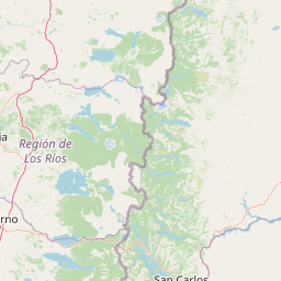
Map view of Huerquehue National Park

Use this park location map to pinpoint Huerquehue National Park in Chile, understand its exact geographic position, and read its mapped placement within the surrounding landscape more clearly.

Pigeon | © OpenStreetMap contributors

Location context for Huerquehue National Park

La Araucanía Region
Natural feature types

Explore the Named Natural Features of Huerquehue National Park

Continue geographic discovery by analyzing the specific natural landforms and water bodies situated within Huerquehue National Park. This index allows users to examine the distribution of glacial features and forest ecosystems that define the park landscape for MoriAtlas research and mapping.
Recorded earthquake history

Review Recorded Seismic Events Near Huerquehue National Park

Consult the historical earthquake database to examine documented seismic activity associated with the geography of Huerquehue National Park. MoriAtlas provides this catalogue as a reference for regional seismic records, featuring data on event magnitude and epicentre distance.

Huerquehue National Park Earthquake History

Catalogued events

21 events

Strongest magnitude

Magnitude 5.1

Most recent event

Dec 24, 2024

This history includes earthquakes recorded inside the park or within 50 km of its borders

Park atlas

Explore mapped geography and connected protected areas across Chile's La Araucanía Region and surrounding Andean foothills.

Discover Other National Parks and Protected Areas Near Huerquehue National Park, Chile

Browse other national parks and protected areas in the region surrounding Huerquehue National Park, showcasing similar Andean foothills, ancient araucaria forests, and glacial lake environments of southern Chile. Compare the geographic spread of these protected landscapes, trace shared ecosystems, and understand their conservation significance for deeper atlas-style park discovery.
National parkNeuquén Province
13 km away#1 closest

South

Lanín National Park: Volcanic Landscapes and Ancient Forests in Neuquén Province

Explore the protected area's mapped terrain and glacial lakes.

Lanín National Park offers a deep dive into the dramatic geography of Argentine Patagonia, centered around the prominent Lanín volcano. This national park preserves ancient araucaria forests, diverse ecosystems, and breathtaking glacial lakes like Huechulafquen and Lácar. Its extensive protected landscape provides critical habitat and opportunities to explore unique Andean terrain through map-driven discovery.

Area
3,790 km²
Established
1937
IUCN
II
Relief
Mountain
National parkLa Araucanía Region
19 km away#2 closest

Southwest

Villarrica National Park: Chile's Protected Landscape in La Araucanía Region

Mapped boundaries and regional geography exploration

Villarrica National Park represents a crucial protected area within the diverse geography of Chile's La Araucanía Region. This atlas-focused entry provides detailed geographic context and mapped park boundaries, essential for understanding the park's landscape identity. Explore the foundational elements of this national park for structured geographic discovery.

Area
630 km²
Established
1940
IUCN
II
Visitors
115.8K annual
National parkLa Araucanía Region
29 km away#3 closest

North

Conguillío National Park: Mapped Protected Landscape and Geographic Context

Discover unique terrain within La Araucanía Region's geography.

Conguillío National Park is a vital protected landscape offering rich opportunities for geographic discovery. This page details the park's specific location within La Araucanía Region, highlighting its mapped natural features and protected boundaries. Understand Conguillío National Park's role as a national park and explore its distinct terrain and regional landscape context.

Area
608 km²
Established
1950
IUCN
II
Visitors
21.8K annual
National parkChile
91 km away#4 closest

North

Tolhuaca National Park National Park: Mapped Boundaries and Chilean Geography

Explore the protected landscape and regional context of this park.

Tolhuaca National Park is a protected national park located in Chile, offering a distinct point for geographic and landscape discovery. This detailed view focuses on the park's mapped boundaries, its environmental setting within Chile, and its overall protected-area identity. Engage with structured data that clarifies its position in the broader atlas of natural landscapes, providing context for regional geography and conservation efforts.

Area
64.74 km²
Established
1935
IUCN
II
Visitors
6.5K annual
National parkNeuquén Province
101 km away#5 closest

East

Laguna Blanca National Park: National Park in Neuquén Province, Patagonia

Mapped protected area and regional landscape context.

Laguna Blanca National Park represents a key protected landscape within the expansive geography of Neuquén Province, located in the Patagonia region of Argentina. This national park entity serves as a critical node for atlas exploration, allowing users to understand its specific protected boundaries and its contribution to the regional protected-area network. Investigate Laguna Blanca National Park to gain insight into its unique geographic setting and its role within the mapped natural areas of Western Argentina.

Area
112.5 km²
Established
1940
IUCN
II
Relief
Upland
National parkRío Negro Province
103 km away#6 closest

South

Nahuel Huapi National Park: Protected Area Landscape and Geographic Context in Río Negro

Explore mapped natural terrain and park boundaries within Patagonia.

Nahuel Huapi National Park is a crucial protected area offering a deep dive into the Patagonian landscape. Situated in Argentina's Río Negro Province, this national park provides a detailed view of mapped natural terrain and its environmental context. Users can explore the park's geographic identity and protected boundaries, making it an essential stop for understanding the regional geography and conservation significance of this part of South America.

Area
7,050 km²
Established
1934
IUCN
II
Relief
Mountain
Watercolor illustration of a mountain range with a lake and forested hills in soft green, pink, and beige tones
National parkLos Lagos Region
138 km away#7 closest

South

Puyehue National Park: Mapped Boundaries and Volcanic Landscape in Los Lagos Region

Explore Chile's dramatic Andean protected area.

Puyehue National Park is a key protected area in the Los Lagos Region of Chile, recognized for its distinctive volcanic landscapes and geothermal features. This detail page offers an atlas-centric view, highlighting the park's mapped boundaries, the terrain shaped by volcanoes like Puyehue, and its ancient temperate rainforest ecosystems. Understand its geographic context within the Andes and its significance as a protected national park.

Area
1,070 km²
Established
1941
IUCN
II
Visitors
133K annual
National parkLos Ríos Region
160 km away#8 closest

Southwest

Alerce Costero National Park: Explore Protected Landscapes and Ancient Forests in Los Ríos Region

Discover mapped terrain and unique Valdivian ecosystem geography.

Alerce Costero National Park stands as a significant protected landscape in Chile's Los Ríos Region, celebrated for its ancient Fitzroya trees and as a sanctuary for the Valdivian temperate rainforest. The park's protected boundaries encompass rugged terrain within the Cordillera Pelada, offering insights into unique watershed geography and the resilience of an ancient forest ecosystem. Its diverse landscape, a mosaic of old-growth woods and natural clearings, provides essential habitat and a remarkable geographic context for atlas exploration.

Area
139.75 km²
Established
2010
IUCN
III
Relief
Mountain

Common questions about visiting, size, designation, and location context for Huerquehue National Park

Huerquehue National Park FAQs for park facts, access, geography, and protected area context

Find quick answers about Huerquehue National Park, including protected-area facts, park geography, trail and visitor context, and how the park fits into its surrounding country and regional landscape.
MoriAtlas Explorer

Continue Your Protected Areas Search Across the Global Atlas

Deepen your exploration by continuing the structured search for national parks and protected areas worldwide. Utilize the comprehensive filtering capabilities to compare different conservation landscapes and refine your understanding of global park geography. Discover more about the distribution and characteristics of protected natural areas.

Global natural geography