

Mori Atlas logo
National parkTolhuaca National Park

Discover the mapped boundaries and regional context of this national park in Chile.

Tolhuaca National Park: Chile's Protected Landscape and Mapped Geographic Identity

Tolhuaca National Park stands as a significant protected area within Chile's diverse geography. This page provides an atlas-driven view of the park, detailing its mapped boundaries and its role as a national park. Users can explore the specific geographic features and landscape context that define Tolhuaca National Park, offering a clear entry point for understanding its protected status and regional significance.

Andean forestsVolcanic landscapeOld-growth forestSouthern beech forestsTemperate rainforestsMountain parks

Tolhuaca National Park

National park

Park overview

Structured park overview, official facts, and landscape profile for Tolhuaca National Park

Tolhuaca National Park park facts, protected area profile, and essential visitor context
Review the core facts for Tolhuaca National Park, including designation, size, terrain, visitor scale, habitats, and operating context in one park-focused overview.

About Tolhuaca National Park

Tolhuaca National Park occupies a mountainous position in the Andean foothills of Chile's La Araucanía Region, in one of the most ecologically significant areas of southern Chile. The park's territory was carved from Malleco National Reserve, which was established in 1907 as Chile's first and South America's inaugural protected wildlife area, giving the forests of Tolhuaca a special place in the continental history of conservation. The park's landscape is characterized by rugged terrain formed by ancient volcanic activity, with the dormant Tolhuaca volcano rising prominently near the park's boundary and shaping the surrounding environment. Within the protected area, visitors encounter a landscape of forested ridges, steep valleys, and numerous bodies of water including the significant Laguna Malleco and Laguna Verde. The park protects the source of the Malleco River, an important waterway in the region. Multiple hiking trails allow exploration of this varied terrain, including paths to waterfalls, lakes, and scenic overlooks. The combination of ancient forest protection, volcanic landscape, and ecological diversity makes Tolhuaca a meaningful destination for understanding Chilean natural heritage.

Quick facts and research context for Tolhuaca National Park

Tolhuaca National Park covers 6,474 hectares in the Andean foothills of southern Chile's La Araucanía Region. The park was established in 1935 through land from Malleco National Reserve, the oldest protected area in Chile and South America, and expanded in 1985 to its current size. Elevation ranges from 700 to 1,821 meters, with the landscape featuring volcanic foothills, dense forests, and numerous lakes and ponds. The park contains the headwaters of the Malleco River and is managed by Chile's National Forest Corporation (CONAF).

Park context

Deeper park guide and search-rich context for Tolhuaca National Park

Tolhuaca National Park history, landscape, wildlife, and travel context
Explore Tolhuaca National Park through its history, landscape character, ecosystems, wildlife, conservation priorities, cultural context, and seasonal travel timing in a structured park guide built for atlas discovery and search intent.

Why Tolhuaca National Park stands out

Tolhuaca National Park is best known for its exceptional old-growth forests dominated by southern beech species and the iconic monkey puzzle tree (Araucaria araucana). The park protects a significant portion of Chile's ancient forest heritage, with its Nothofagus woodlands and araucaria stands representing some of the oldest protected forests in South America. The dramatic landscape, shaped by Andean volcanic terrain and featuring scenic waterfalls such as Salto Malleco (50 meters) and Salto de la Culebra (49 meters), provides a visually striking setting. The park is also notable for its biological importance, supporting rare and endemic species including the frog Alsodes igneus, which is found nowhere else in the world.

Tolhuaca National Park history and protected-area timeline

Tolhuaca National Park was established on October 16, 1935, when an initial area of 3,500 hectares was separated from Malleco National Reserve to create the new protected area. This establishment built upon the pioneering conservation work that created Malleco National Reserve in 1907, which was the first protected wildlife area in Chile and the entire South American continent. The park underwent a significant expansion in 1985 when a second portion of Malleco National Reserve was incorporated, bringing the park to its current extent of 6,474 hectares. This sequential protection approach reflects Chile's long-standing commitment to forest conservation in the Andean regions of Araucanía. The land within Tolhuaca National Park therefore represents some of the oldest continuously protected territory in South America, having been under some form of protection since the early twentieth century.

Tolhuaca National Park landscape and geographic character

The landscape of Tolhuaca National Park is defined by its position on the lower western spurs and foothills of the Andes Mountains in southern Chile. The terrain is mountainous and rugged, shaped by volcanic processes that created the underlying geology and continue to influence the environment through the nearby Tolhuaca volcano. The park encompasses steep ridges, deep valleys, and rolling forested slopes that transition from lower elevations around 700 meters to higher points approaching 1,822 meters. Several small lakes and ponds are scattered throughout the park, with Laguna Malleco and Laguna Verde being the most significant. These water bodies, set among dense forest, create scenic vistas and important habitat for wildlife. The relief is characterized by its complexity and visual drama, with the forest-covered mountains providing a continuously verdant backdrop. The presence of the Malleco River's source within the park adds hydrological significance to the already varied terrain.

Tolhuaca National Park ecosystems, habitats, and plant life

The natural environment of Tolhuaca National Park features forest ecosystems typical of the Chilean Andes, characterized by the southern beech genus Nothofagus and the distinctive araucaria tree. In the park's higher regions, forests are dominated by coihue (Nothofagus dombeyi), lenga beech (Nothofagus pumilio), and Patagonian oak (Nothofagus obliqua), creating layered canopy environments. The iconic monkey puzzle tree (Araucaria araucana), known locally as pehuén, is a prominent feature of the higher forest zones, often displaying yellow lichen growth on its distinctive trunks and branches. The forest composition changes with elevation and aspect, creating diverse habitat conditions. These forests form part of the larger and ecologically significant temperate forest ecosystem of southern South America, representing a conservation priority due to limited global distribution. The forest character varies with seasons, showing summer green density and winter branch patterns.

Tolhuaca National Park wildlife and species highlights

Tolhuaca National Park supports a diverse faunal community across its forest and aquatic habitats. The park's lakes, particularly Laguna Malleco, host significant populations of waterfowl and are monitored by CONAF to track bird species requiring protection. Bird species found in the park include the Andean gull, yellow-billed teal, rosy-billed pochard, lake duck, chimango caracara, buff-necked ibis, Andean condor, ringed kingfisher, and Magellanic woodpecker. Mammal species present include the cougar (puma), coypu, South American gray fox, and the small kodkod cat. The park is notable for supporting rare terrestrial mammals including the pudú, one of the world's smallest deer species, and the monito del monte, a diminutive marsupial endemic to southwestern South America. The frog Alsodes igneus is particularly significant as it is known only from Tolhuaca National Park, representing a species with an extremely restricted global distribution and making the park critically important for its conservation.

Tolhuaca National Park conservation status and protection priorities

Tolhuaca National Park holds significant conservation value as part of one of South America's oldest protected area networks, originating from Malleco National Reserve established in 1907. The park protects old-growth forest ecosystems that are globally limited to the temperate forests of southern Chile and Argentina. The protection of these forests conserves critical habitat for species including the endemic frog Alsodes igneus, which is known only from this location. The monitoring program at Laguna Malleco demonstrates ongoing conservation management, with regular counts of waterbird populations to identify species requiring protective action. The park's forests store carbon, regulate water cycles, and provide habitat for numerous species, including rare and endemic taxa. The long-protected status of this land makes it a significant reservoir of biodiversity and ecological processes in the Andean region of southern Chile.

Tolhuaca National Park cultural meaning and human context

The park lies within the traditional territory of the Mapuche people, an indigenous communities of southern Chile whose ancestral lands encompass much of the La Araucanía Region. Several plant names in the area reflect Mapuche language influence, including coihue derived from the Mapuche term koywe. The monito del monte marsupial is known locally by its Mapuche name chumaihuén. The relationship between the landscape and Mapuche culture is embedded in the place names and local knowledge of the region, though the park's primary designation focuses on natural rather than cultural heritage protection.

Top sights and standout views in Tolhuaca National Park

The park's most distinctive features include the ancient forest landscape of the Andean foothills, the scenic waterfalls of Salto Malleco and Salto de la Culebra, and the tranquil lakes of Laguna Malleco and Laguna Verde. The proximity of the Tolhuaca volcano creates a dramatic backdrop to the forested terrain. The network of four marked hiking trails provides access to these highlights, while the rare pudú and monito del monte represent special wildlife viewing opportunities. The park's status as part of Chile's oldest protected lands gives it historical significance beyond its ecological value. The combination of volcanic landscape, ancient forests, and diverse wildlife creates a comprehensive representation of southern Chilean natural heritage.

Best time to visit Tolhuaca National Park

The park can be visited throughout the year, though the experience varies with Chile's southern hemisphere seasons. The higher elevations experience cold temperatures while valleys are more moderate. Rain occurs throughout the year, so visitors should be prepared for variable conditions. Summer months (December to February) typically offer warmer temperatures and fuller vegetation, making hiking more comfortable, while winter brings colder conditions and potentially more dramatic forest atmosphere. The key consideration is that both access routes require travel on gravel roads and are most reliably passable during the warmer summer months. The park receives relatively few visitors annually, with the majority being Chilean, offering a more secluded experience compared to more heavily visited parks.

Park location guide

Geography guide, regional context, and park location map for Tolhuaca National Park

Tolhuaca National Park park geography, regions, and map view in Chile
Understand where Tolhuaca National Park sits in Chile through a broader geographic reading of the surrounding landscape, nearby location context, and its mapped position within the national park landscape.

How Tolhuaca National Park fits into Chile

Chile is a presidential republic in western South America, extending as a narrow strip along the western edge of the continent between the Andes Mountains and the Pacific Ocean. It is the southernmost country in the world and the closest to Antarctica. The country is bordered by Peru, Bolivia, and Argentina, and administers several Pacific islands including Easter Island. Chile is a major copper producer and has a population of approximately 19.6 million.

Wider geography shaping Tolhuaca National Park in Chile

Chile occupies a narrow strip of land along the western edge of South America, extending approximately 4,300 km north to south but only about 350 km east to west at its widest point. The country is sandwiched between the Andes Mountains to the east and the Pacific Ocean to the west. It shares borders with Peru to the north, Bolivia to the northeast, and Argentina to the east. Southern Chile borders the Drake Passage. Chile also administers several Pacific islands including Juan Fernández Islands, Isla Salas y Gómez, Desventuradas Islands, and Easter Island, plus the Chilean Antarctic Territory.

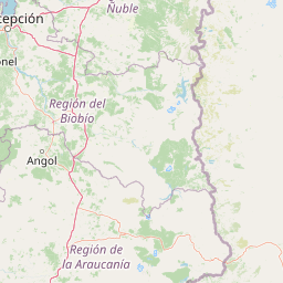
Map view of Tolhuaca National Park

Use this park location map to pinpoint Tolhuaca National Park in Chile, understand its exact geographic position, and read its mapped placement within the surrounding landscape more clearly.

Pigeon | © OpenStreetMap contributors

Location context for Tolhuaca National Park

La Araucanía Region
Park atlas

Discover other protected landscapes across Chile's Andean foothills and compare regional park geography.

Explore Nearby National Parks and Protected Areas Around Tolhuaca National Park
Continue your exploration from Tolhuaca National Park by browsing an atlas of nearby national parks and protected areas, mapping their geographic spread across Chile's Malleco Province. This focused view helps compare diverse protected landscapes, including ancient forests and volcanic terrains, offering deeper insights into regional conservation efforts.
National parkBío Bío Region

Laguna del Laja National Park: Mapped Protected Area in Chile's Bío Bío Region

Explore regional park geography and landscape context.

Laguna del Laja National Park represents a key protected area with distinct geographic attributes within the Bío Bío Region. This profile focuses on its identity as a national park, providing context for its mapped boundaries and natural landscape. Discover its place in regional geography, offering valuable insights for any atlas-focused exploration of Chile's protected lands.

Area
119 km²
Established
1958
IUCN
II
Visitors
48.8K annual
National parkLa Araucanía Region

Huerquehue National Park: Ancient Araucaria Forests and Glacial Lakes in La Araucanía

Mapped protected area in the Andean foothills of Southern Chile.

Delve into the protected landscape of Huerquehue National Park, a key component of Chile's southern conservation efforts within the La Araucanía Region. This national park is defined by its ancient araucaria forests, home to the iconic monkey puzzle tree, and a network of clear glacial lakes including Tinquilco Lake. Its mountainous terrain, rising from 720 to 2,000 meters, showcases a vital representative of the Andean-Patagonian forest ecosystem, offering rich context for map exploration and understanding protected-area geography.

Area
125 km²
Established
1967
IUCN
II
Visitors
35.5K annual
National parkLa Araucanía Region

Nahuelbuta National Park: Ancient Araucaria Forests and Protected Highland Geography

Discover its mapped boundaries atop the Cordillera de Nahuelbuta.

Nahuelbuta National Park is a significant national park in Chile's La Araucanía Region, celebrated for its ancient monkey puzzle tree forests atop the Cordillera de Nahuelbuta. This protected area showcases a unique highland landscape with rugged terrain and exposed rocky outcrops, preserving species more typical of Andean and Patagonian environments. Understanding its mapped geography and protected landscape identity is key to appreciating its ecological importance and distinct position within South America's natural atlas.

Area
68 km²
Established
1939
IUCN
II
Relief
Mountain
National parkNeuquén Province

Laguna Blanca National Park: National Park in Neuquén Province, Patagonia

Mapped protected area and regional landscape context.

Laguna Blanca National Park represents a key protected landscape within the expansive geography of Neuquén Province, located in the Patagonia region of Argentina. This national park entity serves as a critical node for atlas exploration, allowing users to understand its specific protected boundaries and its contribution to the regional protected-area network. Investigate Laguna Blanca National Park to gain insight into its unique geographic setting and its role within the mapped natural areas of Western Argentina.

Area
112.5 km²
Established
1940
IUCN
II
Relief
Upland
National parkNeuquén Province

Lanín National Park: Volcanic Landscapes and Ancient Forests in Neuquén Province

Explore the protected area's mapped terrain and glacial lakes.

Lanín National Park offers a deep dive into the dramatic geography of Argentine Patagonia, centered around the prominent Lanín volcano. This national park preserves ancient araucaria forests, diverse ecosystems, and breathtaking glacial lakes like Huechulafquen and Lácar. Its extensive protected landscape provides critical habitat and opportunities to explore unique Andean terrain through map-driven discovery.

Area
3,790 km²
Established
1937
IUCN
II
Relief
Mountain
National parkLos Ríos Region

Alerce Costero National Park: Explore Protected Landscapes and Ancient Forests in Los Ríos Region

Discover mapped terrain and unique Valdivian ecosystem geography.

Alerce Costero National Park stands as a significant protected landscape in Chile's Los Ríos Region, celebrated for its ancient Fitzroya trees and as a sanctuary for the Valdivian temperate rainforest. The park's protected boundaries encompass rugged terrain within the Cordillera Pelada, offering insights into unique watershed geography and the resilience of an ancient forest ecosystem. Its diverse landscape, a mosaic of old-growth woods and natural clearings, provides essential habitat and a remarkable geographic context for atlas exploration.

Area
139.75 km²
Established
2010
IUCN
III
Relief
Mountain
Watercolor illustration of a mountain range with a lake and forested hills in soft green, pink, and beige tones
National parkLos Lagos Region

Puyehue National Park: Mapped Boundaries and Volcanic Landscape in Los Lagos Region

Explore Chile's dramatic Andean protected area.

Puyehue National Park is a key protected area in the Los Lagos Region of Chile, recognized for its distinctive volcanic landscapes and geothermal features. This detail page offers an atlas-centric view, highlighting the park's mapped boundaries, the terrain shaped by volcanoes like Puyehue, and its ancient temperate rainforest ecosystems. Understand its geographic context within the Andes and its significance as a protected national park.

Area
1,070 km²
Established
1941
IUCN
II
Visitors
133K annual
National parkNeuquén Province

Los Arrayanes National Park: Neuquén Province's Protected Arrayán Forest Atlas

Explore the ancient arrayán forest and mapped terrain.

Los Arrayanes National Park, nestled in Neuquén Province, is celebrated for its exceptional arrayán forest, one of the world's most concentrated stands of Luma apiculata. This protected area showcases a unique landscape where ancient, gnarled trees with striking cinnamon bark thrive on the Quetrihué Peninsula, overlooking Nahuel Huapi Lake. Its protected status ensures the preservation of this botanical marvel, offering a distinct geographical and ecological profile within the Patagonian region.

Area
17.53 km²
Established
1971
IUCN
II
Relief
Upland

Common questions about visiting, size, designation, and location context for Tolhuaca National Park

Tolhuaca National Park FAQs for park facts, access, geography, and protected area context
Find quick answers about Tolhuaca National Park, including protected-area facts, park geography, trail and visitor context, and how the park fits into its surrounding country and regional landscape.
MoriAtlas Explorer

Continue Your Protected Areas Search Across the Global Atlas

Deepen your exploration by continuing the structured search for national parks and protected areas worldwide. Utilize the comprehensive filtering capabilities to compare different conservation landscapes and refine your understanding of global park geography. Discover more about the distribution and characteristics of protected natural areas.

Global natural geography