Mori Atlas logo
National parkLaguna Blanca National Park

Navigate the mapped boundaries and regional geography of this protected natural area.

Laguna Blanca National Park: National Park Protected Landscape in Neuquén Province

(Parque Nacional Laguna Blanca)

Laguna Blanca National Park stands as a significant protected area within the diverse geography of Neuquén Province, Argentina. This national park offers a focused point for understanding Argentina's protected lands and their place in the broader Patagonian atlas. Explore the mapped outlines and inherent natural context of Laguna Blanca National Park for a deeper appreciation of its protected landscape identity.

wetlandPatagonian steppebird sanctuaryRamsar siteprotected areanational park

Laguna Blanca National Park

National park

Park overview

Structured park overview, official facts, and landscape profile for Laguna Blanca National Park

Laguna Blanca National Park park facts, protected area profile, and essential visitor context
Review the core facts for Laguna Blanca National Park, including designation, size, terrain, visitor scale, habitats, and operating context in one park-focused overview.

About Laguna Blanca National Park

Laguna Blanca National Park occupies a unique ecological niche in the Patagonian steppe, protecting a wetland oasis in a landscape otherwise characterized by aridity and sparse vegetation. The park's central feature, Laguna Blanca itself, is a shallow lagoon that provides essential habitat for waterbirds across seasons, supporting populations that depend on its waters for feeding, nesting, and shelter. The creation of the park in 1940 marked a significant early step in Argentina's protected area system, with conservation focused specifically on safeguarding the lagoon ecosystem and its iconic black-necked swan population. The park's location near Zapala places it within accessible distance for visitors seeking to experience the intersection of Patagonian desert landscapes with productive wetland environments. Beyond its ecological significance, the park encompasses archaeological sites including Salamanca cave, where evidence of human occupation and rock art demonstrates the long history of interaction between local populations and this distinctive landscape.

Quick facts and research context for Laguna Blanca National Park

Laguna Blanca National Park spans 112.5 square kilometers in the Patagonian steppe of Neuqué­n Province, Argentina, situated near the town of Zapala at approximately 39°02′S 70°24′W. The park was created in 1940 specifically to protect the lagoon ecosystem and its resident black-necked swan population, marking it as one of Argentina's older protected areas. The lagoon holds Ramsar Wetland status, designated in 1992 under the international Ramsar Convention for its significance as a waterbird habitat. The surrounding landscape features arid hills and gorges typical of the Patagonian plateau, with a climate characterized by extreme temperature variations and low annual rainfall between 150 and 200 millimeters.

Park context

Deeper park guide and search-rich context for Laguna Blanca National Park

Laguna Blanca National Park history, landscape, wildlife, and travel context
Explore Laguna Blanca National Park through its history, landscape character, ecosystems, wildlife, conservation priorities, cultural context, and seasonal travel timing in a structured park guide built for atlas discovery and search intent.

Why Laguna Blanca National Park stands out

Laguna Blanca National Park is most famously known for its significant population of black-necked swans (Cygnus melancoryphus), a species that was the primary motivation for the park's creation in 1940 and remains the defining ecological symbol of the reserve. The lagoon serves as a crucial aquatic bird habitat in the otherwise dry Patagonian steppe, hosting diverse waterfowl species in significant numbers. The park is also notable for its population of the Patagonia frog, an endemic amphibian species that historically thrived in the lagoon but has been largely eliminated from the main waterbody by introduced predatory fish, with surviving populations now confined to isolated ponds in the surrounding buffer zone. The presence of Salamanca cave with prehistoric rock paintings adds an important cultural dimension, representing human occupation typical of northern Patagonia.

Laguna Blanca National Park history and protected-area timeline

Laguna Blanca National Park was established in 1940 as one of Argentina's pioneering national parks, created specifically to provide formal protection for the lagoon and its surrounding ecosystem. The initial focus of conservation was the protection of the black-necked swan population, which had established itself as a resident breeding colony at the lagoon. This designation represented an early recognition of the ecological importance that wetlands in the Patagonian steppe hold for biodiversity conservation. The park received additional international recognition in 1992 when Laguna Blanca was designated as a Ramsar Wetland under the Ramsar Convention, acknowledging its significance as a habitat for waterbird species. The park's management has had to address the challenge of introduced predatory fish that have negatively impacted the native Patagonia frog population, formerly the largest known subpopulation of this endemic amphibian.

Laguna Blanca National Park landscape and geographic character

The landscape of Laguna Blanca National Park presents a striking contrast between the central lagoon and the surrounding Patagonian steppe terrain. The lagoon itself occupies a depression in the terrain, its pale waters providing a visual focal point in an otherwise brown and grey environment of hills and rocky gorges. The surrounding terrain consists of undulating hills characteristic of the Patagonian plateau, with vegetation adapted to arid conditions including scrubland and grass species that can survive on limited moisture. The park sits at an elevation that results in dramatic temperature variations between day and night, with the landscape offering sweeping views across the lagoon from its shores. The combination of water, hills, and steppe creates a distinctive visual environment that draws attention to the ecological significance of this wetland in a desert setting.

Laguna Blanca National Park ecosystems, habitats, and plant life

The nature of Laguna Blanca National Park centers on its function as a wetland ecosystem embedded within the Patagonian steppe. The lagoon provides a productive habitat for aquatic birds, supporting species that depend on open water and emergent vegetation for feeding and breeding. The surrounding steppe environment supports a different suite of species adapted to arid conditions, creating a mosaic of habitats within the park boundaries. The park's designation as a Ramsar Wetland in 1992 reflects the international recognition of its importance as a waterbird habitat, with the shallow lagoon waters supporting feeding and nesting for multiple species. The ecological contrast between the wetland and the surrounding desert creates a biodiversity hotspot in regional terms, with the lagoon serving as an oasis for species that cannot survive in the adjacent dry terrain.

Laguna Blanca National Park wildlife and species highlights

The wildlife of Laguna Blanca National Park is defined by its avian inhabitants, with the black-necked swan serving as the most prominent species and the original motivation for park establishment. The lagoon supports important populations of aquatic birds, with multiple species present in significant numbers throughout the year. The park historically supported substantial populations of the Patagonia frog, an endemic amphibian species unique to this region of Patagonia, but introduced predatory fish have eliminated this species from the main lagoon environment. Surviving populations of the Patagonia frog persist in isolated ponds within the buffer zone surrounding the core protected area, representing an ongoing conservation concern. The broader steppe surrounding the lagoon supports terrestrial wildlife adapted to arid conditions, though the park's primary biodiversity significance lies in its wetland bird communities.

Laguna Blanca National Park conservation status and protection priorities

Laguna Blanca National Park represents an important conservation node in Patagonia, protecting a critical wetland habitat in a region where such environments are scarce and therefore significant. The park's Ramsar designation underscores its international importance as a waterbird habitat, providing formal recognition of the ecological services the lagoon provides. Conservation challenges include managing the impacts of introduced fish species on native amphibian populations and maintaining the ecological integrity of the wetland system. The park serves as a refuge for species that depend on aquatic habitats in an otherwise arid landscape, making its protection particularly important for regional biodiversity. The presence of surviving Patagonia frog populations in buffer zone ponds highlights both the vulnerability of species and the importance of landscape-level conservation approaches.

Laguna Blanca National Park cultural meaning and human context

The cultural context of Laguna Blanca National Park includes evidence of human presence spanning prehistoric periods, with Salamanca cave serving as a significant archaeological site within the park boundaries. The cave contains rock paintings typical of northern Patagonia, demonstrating that this landscape was inhabited by indigenous peoples well before European settlement. Additional Mapuche and prehistoric artifacts have been discovered throughout the park, indicating sustained human occupation and use of this area over time. The lagoon itself likely held cultural significance for local communities given its ecological prominence in the landscape. This human heritage adds dimension to the park's conservation values, demonstrating that the landscape has supported human communities alongside wildlife over extended time periods.

Top sights and standout views in Laguna Blanca National Park

The defining highlights of Laguna Blanca National Park include the sight of black-necked swans on the lagoon, a population that has been protected since the park's creation in 1940 and represents one of the species' key habitats in Patagonia. The Ramsar-designated wetland provides a rare opportunity to observe diverse waterbird species in a steppe environment where such concentrations are uncommon. Visitors can explore Salamanca cave to view prehistoric rock paintings, connecting with the human history of this landscape. The park offers a distinctive combination of wetland and desert environments, with the contrast between the pale lagoon waters and the surrounding brown hills creating memorable scenery. The presence of the endangered Patagonia frog in surrounding buffer zone ponds represents a conservation story that illustrates both the challenges facing native species and ongoing efforts to protect them.

Best time to visit Laguna Blanca National Park

The best time to visit Laguna Blanca National Park depends on what visitors hope to experience, with each season offering different conditions. Summer months bring warmer temperatures that can exceed 40°C during heat waves, making early morning visits more comfortable while providing the opportunity to observe waterbirds actively feeding in the lagoon during cooler hours. Winter brings cold temperatures that can drop to -20°C, with snowfall possible, creating a dramatically different landscape but requiring appropriate preparation for cold conditions. The shoulder seasons of spring and autumn offer moderate temperatures and may provide good conditions for wildlife observation. Bird viewing opportunities exist throughout the year, though the presence of migratory species may vary seasonally.

Park location guide

Geography guide, regional context, and park location map for Laguna Blanca National Park

Laguna Blanca National Park park geography, regions, and map view in Argentina
Understand where Laguna Blanca National Park sits in Argentina through a broader geographic reading of the surrounding landscape, nearby location context, and its mapped position within the national park landscape.

How Laguna Blanca National Park fits into Argentina

Argentina is a federal republic located in the southern cone of South America, bordering Chile, Bolivia, Paraguay, Brazil, Uruguay, and the Atlantic Ocean. With an area of 2,780,085 km², it is the second-largest country in South America and the eighth-largest globally. The capital and largest city is Buenos Aires, and the official language is Spanish. The country claims sovereignty over the Falkland Islands, South Georgia and the South Sandwich Islands, and a portion of Antarctica.

Wider geography shaping Laguna Blanca National Park in Argentina

Argentina occupies the southern portion of South America, sharing the Southern Cone region with Chile to the west. The country borders Bolivia and Paraguay to the north, Brazil to the northeast, Uruguay and the South Atlantic Ocean to the east, and the Drake Passage to the south. The Andes mountain range runs along the western border, while the Pampas plains dominate the central region. Argentina also claims territories in Antarctica.

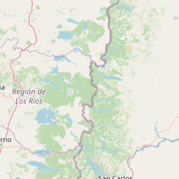
Map view of Laguna Blanca National Park

Use this park location map to pinpoint Laguna Blanca National Park in Argentina, understand its exact geographic position, and read its mapped placement within the surrounding landscape more clearly.

Pigeon | © OpenStreetMap contributors

Location context for Laguna Blanca National Park

Neuquén Province
Park atlas

Browse regional protected landscapes and compare wetland ecosystems, tracing the Patagonian steppe's diverse conservation areas.

Discover Nearby National Parks and Protected Areas Surrounding Laguna Blanca National Park in Patagonia
Explore other national parks and protected areas geographically adjacent to Laguna Blanca National Park, comparing their unique Patagonian steppe landscapes and crucial wetland habitats. Delve into the regional context of conservation, mapping diverse protected areas to understand broader ecological patterns and distinct geological features across this arid environment.
National parkLa Araucanía Region

Huerquehue National Park: Ancient Araucaria Forests and Glacial Lakes in La Araucanía

Mapped protected area in the Andean foothills of Southern Chile.

Delve into the protected landscape of Huerquehue National Park, a key component of Chile's southern conservation efforts within the La Araucanía Region. This national park is defined by its ancient araucaria forests, home to the iconic monkey puzzle tree, and a network of clear glacial lakes including Tinquilco Lake. Its mountainous terrain, rising from 720 to 2,000 meters, showcases a vital representative of the Andean-Patagonian forest ecosystem, offering rich context for map exploration and understanding protected-area geography.

Area
125 km²
Established
1967
IUCN
II
Visitors
35.5K annual
National parkNeuquén Province

Lanín National Park: Volcanic Landscapes and Ancient Forests in Neuquén Province

Explore the protected area's mapped terrain and glacial lakes.

Lanín National Park offers a deep dive into the dramatic geography of Argentine Patagonia, centered around the prominent Lanín volcano. This national park preserves ancient araucaria forests, diverse ecosystems, and breathtaking glacial lakes like Huechulafquen and Lácar. Its extensive protected landscape provides critical habitat and opportunities to explore unique Andean terrain through map-driven discovery.

Area
3,790 km²
Established
1937
IUCN
II
Relief
Mountain
National parkChile

Tolhuaca National Park National Park: Mapped Boundaries and Chilean Geography

Explore the protected landscape and regional context of this park.

Tolhuaca National Park is a protected national park located in Chile, offering a distinct point for geographic and landscape discovery. This detailed view focuses on the park's mapped boundaries, its environmental setting within Chile, and its overall protected-area identity. Engage with structured data that clarifies its position in the broader atlas of natural landscapes, providing context for regional geography and conservation efforts.

Area
64.74 km²
Established
1935
IUCN
II
Visitors
6.5K annual
National parkBío Bío Region

Laguna del Laja National Park: Mapped Protected Area in Chile's Bío Bío Region

Explore regional park geography and landscape context.

Laguna del Laja National Park represents a key protected area with distinct geographic attributes within the Bío Bío Region. This profile focuses on its identity as a national park, providing context for its mapped boundaries and natural landscape. Discover its place in regional geography, offering valuable insights for any atlas-focused exploration of Chile's protected lands.

Area
119 km²
Established
1958
IUCN
II
Visitors
48.8K annual
National parkNeuquén Province

Los Arrayanes National Park: Neuquén Province's Protected Arrayán Forest Atlas

Explore the ancient arrayán forest and mapped terrain.

Los Arrayanes National Park, nestled in Neuquén Province, is celebrated for its exceptional arrayán forest, one of the world's most concentrated stands of Luma apiculata. This protected area showcases a unique landscape where ancient, gnarled trees with striking cinnamon bark thrive on the Quetrihué Peninsula, overlooking Nahuel Huapi Lake. Its protected status ensures the preservation of this botanical marvel, offering a distinct geographical and ecological profile within the Patagonian region.

Area
17.53 km²
Established
1971
IUCN
II
Relief
Upland
Watercolor illustration of a mountain range with a lake and forested hills in soft green, pink, and beige tones
National parkLos Lagos Region

Puyehue National Park: Mapped Boundaries and Volcanic Landscape in Los Lagos Region

Explore Chile's dramatic Andean protected area.

Puyehue National Park is a key protected area in the Los Lagos Region of Chile, recognized for its distinctive volcanic landscapes and geothermal features. This detail page offers an atlas-centric view, highlighting the park's mapped boundaries, the terrain shaped by volcanoes like Puyehue, and its ancient temperate rainforest ecosystems. Understand its geographic context within the Andes and its significance as a protected national park.

Area
1,070 km²
Established
1941
IUCN
II
Visitors
133K annual
National parkRío Negro Province

Nahuel Huapi National Park: Protected Area Landscape and Geographic Context in Río Negro

Explore mapped natural terrain and park boundaries within Patagonia.

Nahuel Huapi National Park is a crucial protected area offering a deep dive into the Patagonian landscape. Situated in Argentina's Río Negro Province, this national park provides a detailed view of mapped natural terrain and its environmental context. Users can explore the park's geographic identity and protected boundaries, making it an essential stop for understanding the regional geography and conservation significance of this part of South America.

Area
7,050 km²
Established
1934
IUCN
II
Relief
Mountain
National parkLa Araucanía Region

Nahuelbuta National Park: Ancient Araucaria Forests and Protected Highland Geography

Discover its mapped boundaries atop the Cordillera de Nahuelbuta.

Nahuelbuta National Park is a significant national park in Chile's La Araucanía Region, celebrated for its ancient monkey puzzle tree forests atop the Cordillera de Nahuelbuta. This protected area showcases a unique highland landscape with rugged terrain and exposed rocky outcrops, preserving species more typical of Andean and Patagonian environments. Understanding its mapped geography and protected landscape identity is key to appreciating its ecological importance and distinct position within South America's natural atlas.

Area
68 km²
Established
1939
IUCN
II
Relief
Mountain

Common questions about visiting, size, designation, and location context for Laguna Blanca National Park

Laguna Blanca National Park FAQs for park facts, access, geography, and protected area context
Find quick answers about Laguna Blanca National Park, including protected-area facts, park geography, trail and visitor context, and how the park fits into its surrounding country and regional landscape.
MoriAtlas Explorer

Continue Your Protected Areas Search Across the Global Atlas

Deepen your exploration by continuing the structured search for national parks and protected areas worldwide. Utilize the comprehensive filtering capabilities to compare different conservation landscapes and refine your understanding of global park geography. Discover more about the distribution and characteristics of protected natural areas.

Global natural geography