

Mori Atlas logo
National parkLaguna del Laja National Park

Discover the mapped boundaries and natural terrain of this significant national park.

Laguna del Laja National Park: Protected Landscape and Regional Geography in Bío Bío

Laguna del Laja National Park stands as a vital protected area within the Bío Bío Region of Chile. This page offers an atlas-centric view, detailing the park's geographic scope and its distinct natural landscape context. Understand its role as a national park and explore its mapped boundaries to appreciate its regional significance.

Volcanic landscapesAndean mountainsTemperate forestsNational parkChileProtected area

Laguna del Laja National Park

National park

Park overview

Structured park overview, official facts, and landscape profile for Laguna del Laja National Park

Laguna del Laja National Park park facts, protected area profile, and essential visitor context
Review the core facts for Laguna del Laja National Park, including designation, size, terrain, visitor scale, habitats, and operating context in one park-focused overview.

About Laguna del Laja National Park

Laguna del Laja National Park occupies a remarkable position in the Andean mountain chain of south-central Chile, protecting a landscape of exceptional topographic and ecological diversity. The park's defining feature is the Antuco Volcano, a symmetrical stratovolcano that rises prominently above the surrounding terrain and serves as the visual anchor of the protected area. Though not heavily glaciated, the volcano's upper reaches receive seasonal snow that contrasts sharply with the vegetated lower slopes. The Sierra Velluda, located south of Antuco, represents the park's highest terrain and receives substantially greater snow accumulation, with its twin summits often retaining snow cover well into the Chilean summer. Between these volcanic peaks, the terrain is carved by sharp ridges and deep valleys that create a classically alpine landscape of considerable visual impact. The park's name derives from Laguna del Laja, a large lake situated near the park's boundary that provides an additional scenic attraction though it lies outside the protected area's strict boundaries. The combination of volcanic geology, significant elevation range, and position within the Temperate Forest zone makes this park an important conservation unit for Chile's natural heritage.

Quick facts and research context for Laguna del Laja National Park

Laguna del Laja National Park is located in the Bío Bío Region of Chile, approximately 30 kilometers east of the city of Los Ángeles. The park was established in 1958 and covers 119 square kilometers of Andean terrain. Its elevation ranges from 976 meters to 3,585 meters at Sierra Velluda, creating significant topographical and ecological diversity. The park is managed by Chile's National Forestry Corporation (CONAF) and received approximately 48,800 visitors in 2012. The protected area lies within the Bío Bío River basin, with several tributaries of the Laja River originating within its boundaries. The park features the iconic Antuco Volcano, the Sierra Velluda massif, and receives more substantial snow coverage on its southern peaks even during the Chilean summer months.

Park context

Deeper park guide and search-rich context for Laguna del Laja National Park

Laguna del Laja National Park history, landscape, wildlife, and travel context
Explore Laguna del Laja National Park through its history, landscape character, ecosystems, wildlife, conservation priorities, cultural context, and seasonal travel timing in a structured park guide built for atlas discovery and search intent.

Why Laguna del Laja National Park stands out

Laguna del Laja National Park is best known for its spectacular volcanic mountain scenery dominated by the symmetrical Antuco Volcano, which rises dramatically above the surrounding landscape. The park's dual-peaked Sierra Velluda massif, with its steep ridges and deep valleys, represents one of the most visually striking mountain formations in the Chilean Andes. The dramatic elevation gradient from 976 to 3,585 meters creates a landscape that alternates between bare rock exposures and lush vegetation zones, offering visitors a compact but intensely varied mountainous experience. The park is also notable for its ice caves that form at the foot of Sierra Velluda during the summer months, a rare geological feature in this latitude. The combination of accessible high-elevation trekking, volcanic landscapes, and the presence of rare and endangered plant species makes this park particularly significant within Chile's protected area network.

Laguna del Laja National Park history and protected-area timeline

Laguna del Laja National Park was established in 1958, making it one of Chile's older national parks predating many of the country's more recent protected area expansions. The park's creation reflected Chile's mid-20th century commitment to preserving representative samples of its diverse natural landscapes, particularly the Andean environments that were increasingly recognized for their ecological and scenic value. Management of the park falls to the Corporación Nacional Forestal (CONAF), Chile's national forestry and protected area management agency. The park's establishment also coincided with growing scientific interest in the unique temperate forest ecosystems of south-central Chile, which differ markedly from the tropical or arid environments that dominate much of the country's territory. Over the decades, the park has maintained its protected status while developing as a destination for mountaineering and wilderness recreation, serving both conservation objectives and public enjoyment of Chile's natural landscapes.

Laguna del Laja National Park landscape and geographic character

The landscape of Laguna del Laja National Park is defined by its dramatic volcanic topography and the processes that have shaped the Andean cordillera over millions of years. The park's terrain is dominated by two major volcanic formations: the Antuco Volcano and the Sierra Velluda massif, which together create a landscape of steep summits, sharp ridges, and deeply incised valleys. Antuco Volcano presents a relatively simple conical profile that rises to approximately 2,985 meters, while Sierra Velluda reaches 3,585 meters with a more complex twin-peak structure that supports greater snow accumulation. Between these major features, the terrain drops through a series of steep-walled valleys carved by glacial and fluvial processes, exposing bare rock faces alongside areas of dense vegetation. The park's elevation range of over 2,600 meters creates distinct landscape zones, from the forest-covered lower slopes to the alpine rock and snow fields above. Small tributaries originating within the park feed into the Laja River system, which ultimately drains into the Bío Bío River, connecting the park's high mountain environments to broader watershed systems.

Laguna del Laja National Park ecosystems, habitats, and plant life

The park lies within the globally significant Valdivian temperate forests ecoregion, one of the few remaining examples of the temperate rainforests that once covered much of southern South America's Pacific coast. This ecoregion is characterized by high rainfall, mild temperatures, and forest communities dominated by species with southern hemisphere distributions. Within the park's boundaries, the vegetation transitions from dense forest on the lower slopes through transitional woodland zones to sparse alpine vegetation at higher elevations. The park protects several plant species of conservation concern, including the ciprés de la cordillera (Austrocedrus chilensis), a conifer endemic to the Chilean and Argentine Andes, and the araucaria (Araucaria araucana), also known as the monkey puzzle tree, which is Chile's national tree and occurs in restricted populations throughout the Andes. Additional rare species include maitén del Chubut and radal enano, both representing the diverse shrub and understory communities that complete the forest ecosystem. The park's position at the transition between Andean and Patagonian floral zones gives it particular ecological significance.

Laguna del Laja National Park wildlife and species highlights

Laguna del Laja National Park supports a diverse community of wildlife typical of the Andean temperate forest environment. The park is home to the cougar (Puma concolor), South America's largest felid and an apex predator that roams the park's mountainous terrain in search of prey species. Two species of foxes are present: the chilla (Lycalopex griseus), also known as the South American gray fox, and the culpeo (Lycalopex culpaeus), the larger of Chile's native fox species. The park's bird fauna includes at least 47 documented species, representing both resident and migratory components of the regional avifauna. The variety of habitats created by the park's elevation gradient, from forest-covered valleys to alpine rock fields, supports different ecological communities and contributes to the overall species richness found within the protected area.

Laguna del Laja National Park conservation status and protection priorities

Laguna del Laja National Park plays an important role in Chile's protected area network by preserving a representative sample of Andean volcanic landscapes and associated temperate forest ecosystems. The park's IUCN Category II designation reflects its primary objective of protecting natural ecosystems while allowing for sustainable visitation and environmental education. The presence of species such as the cougar, araucaria, and ciprés de la cordillera demonstrates the park's conservation value for both charismatic megafauna and rare plant species. The park's location within the Bío Bío River basin also connects it to broader watershed conservation objectives, as the protected headwater areas help maintain water quality and regulate downstream flow. Management by CONAF ensures that conservation priorities are balanced with visitor access, with infrastructure and activities designed to minimize environmental impact while allowing people to experience this Andean wilderness.

Laguna del Laja National Park cultural meaning and human context

Laguna del Laja National Park exists within a region of south-central Chile that has been inhabited by indigenous communities for millennia, though the park's high-elevation environment has historically limited permanent settlement within its boundaries. The park's name derives from Spanish colonial period usage, with "laguna" referring to the nearby lake and "laja" possibly relating to local geological features or early land grants. The broader Bío Bío Region contains significant Mapuche cultural heritage, and the park's adjacent landscapes include areas of traditional indigenous land use. The park's establishment in 1958 reflected mid-century Chilean national priorities that emphasized wilderness preservation alongside economic development of natural resources.

Best time to visit Laguna del Laja National Park

The optimal time to visit Laguna del Laja National Park depends on visitor preferences and intended activities. The Chilean summer months from December through March offer the most reliable conditions for trekking and climbing, with warmer temperatures and generally stable weather allowing access to higher elevations. During this period, the park's landscapes are at their most accessible, though snow coverage on Sierra Velluda may be limited compared to winter conditions. Winter months (June through August) transform the park into a skiing destination but bring more challenging conditions including snow closure of higher trails and reduced facilities. The shoulder seasons of spring and autumn offer fewer visitors and the opportunity to observe seasonal changes in the park's vegetation and wildlife, though weather can be less predictable.

Park location guide

Geography guide, regional context, and park location map for Laguna del Laja National Park

Laguna del Laja National Park park geography, regions, and map view in Chile
Understand where Laguna del Laja National Park sits in Chile through a broader geographic reading of the surrounding landscape, nearby location context, and its mapped position within the national park landscape.

How Laguna del Laja National Park fits into Chile

Chile is a presidential republic in western South America, extending as a narrow strip along the western edge of the continent between the Andes Mountains and the Pacific Ocean. It is the southernmost country in the world and the closest to Antarctica. The country is bordered by Peru, Bolivia, and Argentina, and administers several Pacific islands including Easter Island. Chile is a major copper producer and has a population of approximately 19.6 million.

Wider geography shaping Laguna del Laja National Park in Chile

Chile occupies a narrow strip of land along the western edge of South America, extending approximately 4,300 km north to south but only about 350 km east to west at its widest point. The country is sandwiched between the Andes Mountains to the east and the Pacific Ocean to the west. It shares borders with Peru to the north, Bolivia to the northeast, and Argentina to the east. Southern Chile borders the Drake Passage. Chile also administers several Pacific islands including Juan Fernández Islands, Isla Salas y Gómez, Desventuradas Islands, and Easter Island, plus the Chilean Antarctic Territory.

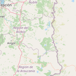
Map view of Laguna del Laja National Park

Use this park location map to pinpoint Laguna del Laja National Park in Chile, understand its exact geographic position, and read its mapped placement within the surrounding landscape more clearly.

Pigeon | © OpenStreetMap contributors

Location context for Laguna del Laja National Park

Bío Bío Region
Park atlas

Compare similar Andean mountain park geography and explore volcanic protected landscapes across the surrounding Chilean region.

Discover Other National Parks and Protected Areas Near Laguna del Laja National Park
After exploring Laguna del Laja National Park's volcanic peaks and temperate forests, continue discovering other nearby national parks and significant conservation areas in the Chilean Andes. Trace similar high-elevation trekking landscapes, dramatic mountain ranges, and unique Valdivian ecoregions across the Bío Bío Region and wider South-Central Chile for enhanced geographic comparison.
National parkChile

Tolhuaca National Park National Park: Mapped Boundaries and Chilean Geography

Explore the protected landscape and regional context of this park.

Tolhuaca National Park is a protected national park located in Chile, offering a distinct point for geographic and landscape discovery. This detailed view focuses on the park's mapped boundaries, its environmental setting within Chile, and its overall protected-area identity. Engage with structured data that clarifies its position in the broader atlas of natural landscapes, providing context for regional geography and conservation efforts.

Area
64.74 km²
Established
1935
IUCN
II
Visitors
6.5K annual
National parkLa Araucanía Region

Nahuelbuta National Park: Ancient Araucaria Forests and Protected Highland Geography

Discover its mapped boundaries atop the Cordillera de Nahuelbuta.

Nahuelbuta National Park is a significant national park in Chile's La Araucanía Region, celebrated for its ancient monkey puzzle tree forests atop the Cordillera de Nahuelbuta. This protected area showcases a unique highland landscape with rugged terrain and exposed rocky outcrops, preserving species more typical of Andean and Patagonian environments. Understanding its mapped geography and protected landscape identity is key to appreciating its ecological importance and distinct position within South America's natural atlas.

Area
68 km²
Established
1939
IUCN
II
Relief
Mountain
National parkLa Araucanía Region

Huerquehue National Park: Ancient Araucaria Forests and Glacial Lakes in La Araucanía

Mapped protected area in the Andean foothills of Southern Chile.

Delve into the protected landscape of Huerquehue National Park, a key component of Chile's southern conservation efforts within the La Araucanía Region. This national park is defined by its ancient araucaria forests, home to the iconic monkey puzzle tree, and a network of clear glacial lakes including Tinquilco Lake. Its mountainous terrain, rising from 720 to 2,000 meters, showcases a vital representative of the Andean-Patagonian forest ecosystem, offering rich context for map exploration and understanding protected-area geography.

Area
125 km²
Established
1967
IUCN
II
Visitors
35.5K annual
National parkNeuquén Province

Laguna Blanca National Park: National Park in Neuquén Province, Patagonia

Mapped protected area and regional landscape context.

Laguna Blanca National Park represents a key protected landscape within the expansive geography of Neuquén Province, located in the Patagonia region of Argentina. This national park entity serves as a critical node for atlas exploration, allowing users to understand its specific protected boundaries and its contribution to the regional protected-area network. Investigate Laguna Blanca National Park to gain insight into its unique geographic setting and its role within the mapped natural areas of Western Argentina.

Area
112.5 km²
Established
1940
IUCN
II
Relief
Upland
National parkNeuquén Province

Lanín National Park: Volcanic Landscapes and Ancient Forests in Neuquén Province

Explore the protected area's mapped terrain and glacial lakes.

Lanín National Park offers a deep dive into the dramatic geography of Argentine Patagonia, centered around the prominent Lanín volcano. This national park preserves ancient araucaria forests, diverse ecosystems, and breathtaking glacial lakes like Huechulafquen and Lácar. Its extensive protected landscape provides critical habitat and opportunities to explore unique Andean terrain through map-driven discovery.

Area
3,790 km²
Established
1937
IUCN
II
Relief
Mountain
National parkLos Ríos Region

Alerce Costero National Park: Explore Protected Landscapes and Ancient Forests in Los Ríos Region

Discover mapped terrain and unique Valdivian ecosystem geography.

Alerce Costero National Park stands as a significant protected landscape in Chile's Los Ríos Region, celebrated for its ancient Fitzroya trees and as a sanctuary for the Valdivian temperate rainforest. The park's protected boundaries encompass rugged terrain within the Cordillera Pelada, offering insights into unique watershed geography and the resilience of an ancient forest ecosystem. Its diverse landscape, a mosaic of old-growth woods and natural clearings, provides essential habitat and a remarkable geographic context for atlas exploration.

Area
139.75 km²
Established
2010
IUCN
III
Relief
Mountain
National parkLibertador General Bernardo O'Higgins Region

Las Palmas de Cocalán National Park: Chile's National Park Protected Landscape Atlas

Explore geographic boundaries and regional context.

Delve into the protected landscape identity of Las Palmas de Cocalán National Park, situated within the Libertador General Bernardo O'Higgins Region. This page provides detailed atlas-style information, focusing on the park's geographic features and its role as a national park. Understand the mapped natural terrain and the regional importance of this conserved area for comprehensive geographic discovery.

Area
3.709 km²
Established
1971
IUCN
II
Relief
Mixed relief
Watercolor illustration of a mountain range with a lake and forested hills in soft green, pink, and beige tones
National parkLos Lagos Region

Puyehue National Park: Mapped Boundaries and Volcanic Landscape in Los Lagos Region

Explore Chile's dramatic Andean protected area.

Puyehue National Park is a key protected area in the Los Lagos Region of Chile, recognized for its distinctive volcanic landscapes and geothermal features. This detail page offers an atlas-centric view, highlighting the park's mapped boundaries, the terrain shaped by volcanoes like Puyehue, and its ancient temperate rainforest ecosystems. Understand its geographic context within the Andes and its significance as a protected national park.

Area
1,070 km²
Established
1941
IUCN
II
Visitors
133K annual

Common questions about visiting, size, designation, and location context for Laguna del Laja National Park

Laguna del Laja National Park FAQs for park facts, access, geography, and protected area context
Find quick answers about Laguna del Laja National Park, including protected-area facts, park geography, trail and visitor context, and how the park fits into its surrounding country and regional landscape.
MoriAtlas Explorer

Continue Your Protected Areas Search Across the Global Atlas

Deepen your exploration by continuing the structured search for national parks and protected areas worldwide. Utilize the comprehensive filtering capabilities to compare different conservation landscapes and refine your understanding of global park geography. Discover more about the distribution and characteristics of protected natural areas.

Global natural geography