Mori Atlas logo
National parkHundred Islands National Park

Discover the protected landscape and geographic boundaries of this key national park.

Hundred Islands National Park: A Mapped National Park in Pangasinan, Philippines

Hundred Islands National Park serves as a significant protected area within the Philippines, offering a unique geographic focus for atlas exploration. Situated in Pangasinan, this national park presents a distinct natural landscape defined by its mapped boundaries and regional context. MoriAtlas provides detailed geographic information, enabling users to understand the park's placement and its role as a protected natural site within the broader Philippine geography.

Karst LandscapeArchipelagoMarine Protected AreaGeological MonumentIsland EcosystemsBeach Forests

Hundred Islands National Park

National park

Park overview

Structured park overview, official facts, and landscape profile for Hundred Islands National Park

Hundred Islands National Park park facts, protected area profile, and essential visitor context
Review the core facts for Hundred Islands National Park, including designation, size, terrain, visitor scale, habitats, and operating context in one park-focused overview.

About Hundred Islands National Park

Hundred Islands National Park represents a unique coastal protected area in the Philippines that combines geological significance, ecological diversity, and historical importance in a single archipelago setting. The park comprises between 123 and 124 islands depending on tidal conditions, scattered across Lingayen Gulf in the northwestern portion of Luzon island. The limestone and karst formations that characterize these islands are estimated to be approximately two million years old, with ancient coral formations extending well inland in areas that were once part of the seabed. The distinctive mushroom-like shapes of several islands resulted from the erosive action of ocean waves over geological time, creating visually striking formations that have become symbolic of the park's character. The park was created through Presidential Proclamation No. 667 signed by President Manuel L. Quezon on January 18, 1940, originally covering 16.76 square kilometers for the benefit and enjoyment of the Filipino people. Over the decades, management of the park transitioned through various governmental bodies, from the Hundred Islands Conservation and Development Authority to the Philippine Tourism Authority, and finally to the city government of Alaminos in 2005 under Executive Order No. 436. This transition reflected the Philippines' broader devolution of authority to local government units as mandated by the Local Government Code of 1991.

Quick facts and research context for Hundred Islands National Park

Hundred Islands National Park occupies a coastal archipelago setting in northwestern Luzon, Philippines, within Lingayen Gulf off the coast of Pangasinan province. The park was established on January 18, 1940, making it the Philippines' first national park and one of the oldest protected areas in the country. The island cluster consists of karst limestone formations approximately two million years old, with ancient coral formations visible well inland, evidence of the geological history when these areas formed part of a prehistoric seabed. The park falls under the management of the Department of Environment and Natural Resources and is recognized as a National Geological Monument, highlighting its significant scientific and educational value. Visitor access is concentrated on four developed islands, while the majority of the archipelago remains in a relatively natural state due to the rugged and inaccessible terrain of many islands.

Park context

Deeper park guide and search-rich context for Hundred Islands National Park

Hundred Islands National Park history, landscape, wildlife, and travel context
Explore Hundred Islands National Park through its history, landscape character, ecosystems, wildlife, conservation priorities, cultural context, and seasonal travel timing in a structured park guide built for atlas discovery and search intent.

Why Hundred Islands National Park stands out

Hundred Islands National Park is best known for its extraordinary karst limestone archipelago, a rare geological formation in the Philippines that produces the distinctive mushroom-like island shapes sculpted by wave erosion over millions of years. The park's identity is defined by the visual drama of dozens of limestone islands rising from turquoise waters, creating a landscape unlike anywhere else in the country. As the Philippines' oldest national park, it carries significant historical and cultural importance in the nation's conservation history. The area is also recognized for its biodiversity, with both terrestrial and marine ecosystems supporting species that thrive in the unique habitat transitions between beach forest, limestone karst, and marine environments.

Hundred Islands National Park history and protected-area timeline

The establishment of Hundred Islands National Park in 1940 marked a milestone in Philippine conservation history as the country's first national park, created through Presidential Proclamation No. 667 signed by President Manuel L. Quezon. The original protected area encompassed 16.76 square kilometers designated for the benefit and enjoyment of the Filipino people. In 1962, Republic Act No. 3655 established the Hundred Islands Conservation and Development Authority to manage the park's conservation, development, and management. The park, including Lucap Bay, was transferred from this authority to the Philippine Tourism Authority in 1974 through Presidential Decree No. 564. On April 27, 1982, the national park and surrounding marine areas were declared a Tourist Zone and Marine Reserve under Proclamation No. 2183, placing it under the control of the Philippine Tourism Authority. The park's geological significance was formally recognized in 2001 when the National Committee on Geological Sciences declared the site a National Geological Monument, acknowledging its unique karst landscape and scientific value. A significant administrative change occurred in 2005 when Executive Order No. 436 transferred administration of the entire park from the Philippine Tourism Authority to the city government of Alaminos, aligning with the country's government devolution program. A 55-foot statue of Christ the Savior was placed atop Pilgrimage Island, developing it as a pilgrimage site.

Hundred Islands National Park landscape and geographic character

The Hundred Islands National Park landscape is defined by its extraordinary karst limestone archipelago, a formation unlike any other in the Philippines. The islands rise abruptly from the waters of Lingayen Gulf, their jagged limestone cliffs and peaks creating a dramatic seascape that changes character with the light and tide. The characteristic mushroom-like shapes of several islands resulted from wave erosion acting on the softer limestone over millions of years, producing formations that resemble giant mushrooms perched on smaller bases. Ancient coral formations extend well inland across many islands, visible in areas that were once part of the seabed before sea levels dropped to expose these prehistoric marine structures. The terrain of most islands is rugged and steep, with dense vegetation covering the limestone outcrops where they are accessible. The surrounding waters of Lingayen Gulf are generally shallow in parts but drop to deeper channels between islands, creating varied marine environments. The combination of dramatic limestone silhouettes rising from turquoise waters, beach forest margins, and the open gulf setting produces one of the most visually distinctive protected landscapes in Southeast Asia.

Hundred Islands National Park ecosystems, habitats, and plant life

The nature of Hundred Islands National Park encompasses both terrestrial and marine ecosystems that thrive in the unique environment created by the karst archipelago. Beach forest species dominate the island vegetation, with Terminalia and agoho among the most abundant trees across the islands. Other significant tree species include molave, malaikmo, and sablot, species commonly associated with limestone and karst forest habitats. Several exotic species have been introduced to the islands over time, including the fire tree, calachuchi, atis, sineguelas, sampaloc, and ipil-ipil. The rugged and inaccessible nature of many islands has allowed vegetation to remain relatively intact, preserving what would otherwise be disturbed forest communities. The marine environment around the islands supports diverse fish populations including thresher sharks, angelfish, and butterflyfish, while crustaceans such as ghost crabs and hermit crabs inhabit the shoreline areas. A 2010 biodiversity assessment conducted by the Marine Environment and Resources Foundation Inc. created an inventory of flora and fauna to support environmental monitoring efforts by the city government of Alaminos.

Hundred Islands National Park wildlife and species highlights

Wildlife in Hundred Islands National Park reflects the transitional nature of the islands between terrestrial and marine environments. The bird fauna includes several Philippine endemic species such as the Philippine duck, white-eared brown-dove, Philippine hawk-cuckoo, Philippine coucal, Philippine bulbul, elegant tit, lemon-throated leaf-warbler, and grey-backed tailorbird. These species occupy different habitats within the island ecosystem, from beach areas to forest canopy. The marine wildlife is equally diverse, with fish species including thresher sharks, various angelfish, and butterflyfish populating the waters around the islands. Shoreline areas support crustacean populations including ghost crabs and hermit crabs, which are commonly observed in the intertidal zones. The forest-dwelling species benefit from the relatively intact vegetation on many islands, particularly those that remain inaccessible due to their steep terrain. The combination of forest, beach, and marine habitats within the relatively small archipelago creates concentrated biodiversity value across a limited area.

Hundred Islands National Park conservation status and protection priorities

Hundred Islands National Park holds significant conservation importance as the Philippines' oldest national park, representing decades of protected area management and evolving conservation approaches. The designation as a National Geological Monument in 2001 by the National Committee on Geological Sciences recognizes the site's unique scientific and educational value, highlighting the karst landscape's geological significance not just for the Philippines but globally. The park faces ongoing conservation challenges typical of island ecosystems, where limited area and isolation create vulnerability to environmental changes and human impacts. The 2010 Sagip Lingayen Gulf Project, funded by the Dutch government and implemented by the Marine Environment and Resources Foundation Inc., represented a major effort to assess and inventory the islands' biodiversity, responding to the lack of comprehensive resources on terrestrial wildlife. This research supports the city government of Alaminos in developing environmental monitoring programs to protect the islands' biodiversity. The transition of administration to the local government in 2005 reflected a broader trend in Philippine environmental management toward decentralization, allowing more localized decision-making in conservation efforts.

Hundred Islands National Park cultural meaning and human context

Hundred Islands National Park exists within the cultural context of Pangasinan province, a region with its own distinct language and identity within the Philippines. The local Pangasinan language refers to the park as either Kapulo-puloan or Taytay-Bakes, reflecting how the area is perceived by residents. The park's location near Alaminos means it is deeply connected to the city's identity and economy, with tourism centered on the developed islands providing visitor experiences and local employment. The presence of Pilgrimage Island, featuring a 55-foot statue of Christ the Savior, adds a religious dimension to the park's cultural landscape, creating a destination that serves both recreational and spiritual visitors. The naming of islands such as Governor Island, Quezon Island, and Children's Island reflects administrative and historical naming conventions, while other islands have become associated with popular culture through their use in television productions. The park's establishment as the country's first national park in 1940 marked an important moment in the development of Philippine environmental consciousness and protected area management.

Top sights and standout views in Hundred Islands National Park

The most distinctive highlight of Hundred Islands National Park is its remarkable karst archipelago, with over 100 islands rising from Lingayen Gulf in configurations unlike any other protected area in the Philippines. The mushroom-like limestone formations created by millions of years of wave erosion represent a geological showcase that led to the park's designation as a National Geological Monument. The park's status as the first Philippine national park gives it historical significance that extends beyond its ecological value, representing the birthplace of the country's protected area system. The dramatic visual impact of the island cluster, particularly at sunrise and sunset when the limestone takes on warm hues against the sea, creates an experience that draws visitors from across the Philippines and internationally. The relative wildness of most islands, with only four developed for tourism, means that the majority of the archipelago retains a natural character that is increasingly rare in accessible protected areas. The transition from marine environments to beach forest to karst interior creates remarkable habitat diversity within a compact area.

Best time to visit Hundred Islands National Park

The best time to visit Hundred Islands National Park is during the dry season from November to May, when weather conditions are most favorable for island exploration and water activities. The Philippine climate features distinct wet and dry seasons, with the dry months offering lower rainfall, clearer skies, and more predictable sea conditions that enhance the experience of traveling between islands. During the wet season from June to October, heavy rains and potential storms can disrupt boat services and reduce visibility, though the islands remain accessible. The period between March and May tends to be warmest, while the cooler months from December to February offer more comfortable conditions for daytime exploration. Visitors seeking to avoid crowds may find the shoulder seasons of November and May offer a balance between favorable weather and reduced tourist numbers. The park can be visited year-round, but the dry season provides the most reliable conditions for experiencing the full range of activities and island destinations that the park offers.

Park location guide

Geography guide, regional context, and park location map for Hundred Islands National Park

Hundred Islands National Park park geography, regions, and map view in Philippines
Understand where Hundred Islands National Park sits in Philippines through a broader geographic reading of the surrounding landscape, nearby location context, and its mapped position within the national park landscape.

How Hundred Islands National Park fits into Philippines

The Philippines, officially the Republic of the Philippines, is an archipelagic nation in Southeast Asia comprising approximately 7,641 islands categorized into three main geographical divisions: Luzon, Visayas, and Mindanao. Located in the western Pacific Ocean, it shares maritime borders with Taiwan, Japan, Palau, Indonesia, Malaysia, Vietnam, and China. Manila serves as the capital city, while Quezon City is the most populated city, both within Metro Manila.

Wider geography shaping Hundred Islands National Park in Philippines

The Philippines is an archipelagic nation in Southeast Asia, positioned in the western Pacific Ocean. Its islands are bounded by the South China Sea to the west, Philippine Sea to the east, and Celebes Sea to the south. The country shares maritime borders with Taiwan to the north, Japan to the northeast, Palau to the east and southeast, Indonesia to the south, Malaysia to the southwest, Vietnam to the west, and China to the northwest.

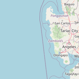
Map view of Hundred Islands National Park

Use this park location map to pinpoint Hundred Islands National Park in Philippines, understand its exact geographic position, and read its mapped placement within the surrounding landscape more clearly.

Pigeon | © OpenStreetMap contributors

Location context for Hundred Islands National Park

Pangasinan
Park atlas

Trace the regional spread of diverse protected landscapes and compare park geography in the Philippines.

Discover More National Parks and Protected Areas Near Hundred Islands National Park
Continue your journey from Hundred Islands National Park to discover other national parks and protected areas, exploring the Philippines' diverse conservation landscapes. Compare varied park geography, from coastal marine reserves to other inland protected areas, tracing the regional context of conservation sites across the archipelago.
National parkNueva Vizcaya

Bangan Hill National Park: A Protected Landscape within Nueva Vizcaya's Geography

Explore its mapped terrain and cultural significance.

Bangan Hill National Park is a crucial protected area nestled in Nueva Vizcaya, Philippines. This page details its specific geography, including its role as a distinct hill within the broader Cagayan Valley landscape. Users can explore the park's mapped boundaries, understand its role as a national park, and discover the surrounding mountain context of the Caraballo and Cordillera Central ranges. It offers a unique perspective on the region's natural and historical significance, serving as a focal point for protected landscape exploration.

Area
0.139 km²
Established
1995
IUCN
II
Relief
Mixed relief
National parkIlocos Sur

Northern Luzon Heroes Hill National Park: Coastal Mountain Geography and Protected Landscape Identity

Discover the mapped terrain and forest boundaries of this Philippine national park.

Northern Luzon Heroes Hill National Park offers a detailed look at a unique protected landscape in the Philippines' Ilocos Sur region. Its dramatic coastal mountain geography, characterized by steep forested slopes and ravines, stands apart from the typical flat terrain of the area. This national park serves as a significant mapped natural area, preserving vital forest cover and providing insights into the region's ecological context and landscape diversity.

Area
13.16 km²
Established
1963
IUCN
V
Relief
Mixed relief
Illustration of a river with bamboo boats, people rowing, limestone cliffs, and trees
National parkNueva Ecija

Minalungao National Park: Protected Landscape and Geographic Context in Nueva Ecija

Explore the mapped boundaries of this Philippines national park.

Delve into the specifics of Minalungao National Park, a protected natural area identified as a national park in the Philippines. This exploration focuses on its distinct geographic identity within Nueva Ecija, highlighting the importance of its mapped boundaries and regional landscape. Understand the park's role as a protected land entity for atlas-based discovery.

Area
20.18 km²
Established
1967
IUCN
V
Relief
Upland
National parkZambales

Olongapo Naval Base Perimeter National Park: Philippines National Park & Protected Landscape in Zambales

Coastal terrain and historical military land context.

Discover Olongapo Naval Base Perimeter National Park, a protected landscape within Zambales province, Philippines. Established adjacent to the former U.S. Naval Base Subic Bay perimeter, this small national park preserves a unique coastal fringe. Its mapped boundaries offer insights into a transitional zone, serving as a green corridor and protecting a fragment of the region's natural habitat. Explore the distinct geographical and historical significance of this protected area.

Area
0.09 km²
Established
1968
IUCN
V
Scope
Terrestrial
National parkBulacan

Biak-na-Bato National Park: National Park Atlas and Geographic Context in Bulacan

Explore protected landscapes and mapped terrain.

Biak-na-Bato National Park is a key protected area in Bulacan, Philippines, identified for its national park designation. This entry provides specific details on its geographic positioning and mapped features, essential for atlas-based research and understanding the distribution of protected lands within the region. Dive into the landscape context and mapped boundaries that define this significant natural entity.

Area
21.17 km²
Established
1937
IUCN
V
Relief
Mountain
National parkPhilippines

Aurora Memorial National Park: A Protected Landscape in the Philippines' Sierra Madre

Explore mapped boundaries and endemic avian habitat.

Aurora Memorial National Park represents a critical conservation area situated within the Philippines' Sierra Madre mountain range. Spanning a significant stretch along the eastern mountain slopes, this national park is characterized by its lowland dipterocarp forest ecosystem, recognized for supporting diverse flora and fauna. It is particularly noted as an Important Bird Area, crucial for endemic species like the Philippine eagle and various other avian populations, highlighting its ecological significance within the archipelago's geography.

Area
56.76 km²
Established
1937
IUCN
V
Relief
Mountain
National parkCordillera Administrative Region

Balbalasang, Balbalan National Park: Mapped Protected Area in Cordillera Administrative Region

Explore its national park geography and landscape context.

Balbalasang, Balbalan National Park offers a distinct protected landscape within the Philippines' Cordillera Administrative Region. This canonical detail page provides an atlas-driven perspective, focusing on the park's mapped boundaries and its regional geographic context. Users can delve into the specific terrain and natural features that define this national park, enhancing their understanding of its protected area status and its significance in landscape exploration.

Area
13.38 km²
Established
1972
IUCN
II
Relief
Mountain
Watercolor painting of a landscape with rolling hills, trees, distant mountains, and small structures
National parkAbra

Cassamata Hill National Park: Philippine National Park with Hilltop Views of Abra Valley

Mapped geography of the Abra River valley and surrounding mountain ranges.

Cassamata Hill National Park is a protected landscape in Abra, Philippines, notable for its summit viewpoints that capture the expansive Abra River valley and the imposing Cordillera Central and Ilocos mountain ranges. Visitors can explore the mapped terrain from this elevated vantage point, offering a comprehensive view of the regional geography, including the distinctive silhouette of Mount Banti Goolong, also known as the Sleeping Beauty. This national park provides crucial insight into the protected area's context within the broader Cordillera region.

Area
0.57 km²
Established
1974
IUCN
V
Relief
Upland

Common questions about visiting, size, designation, and location context for Hundred Islands National Park

Hundred Islands National Park FAQs for park facts, access, geography, and protected area context
Find quick answers about Hundred Islands National Park, including protected-area facts, park geography, trail and visitor context, and how the park fits into its surrounding country and regional landscape.
MoriAtlas Explorer

Continue Your Protected Areas Search Across the Global Atlas

Deepen your exploration by continuing the structured search for national parks and protected areas worldwide. Utilize the comprehensive filtering capabilities to compare different conservation landscapes and refine your understanding of global park geography. Discover more about the distribution and characteristics of protected natural areas.

Global natural geography