Why Isla Magdalena National Park stands out
Isla Magdalena National Park is best known for its spectacular Patagonian wilderness character, combining dense Magellanic forests with volcanic mountain terrain in a remote island setting. The park protects one of the more extensive tracts of contiguous wilderness in Chilean Patagonia, with its wet, cool climate supporting unique ecological communities adapted to the extreme conditions. The absence of road infrastructure has kept this landscape remarkably undeveloped, preserving its wild character. The volcanic peak of Mentolat Volcano provides dramatic high-country terrain, while the numerous smaller islands surrounding Magdalena add coastal diversity to the protected area.
Isla Magdalena National Park history and protected-area timeline
The protection history of Isla Magdalena National Park begins in 1967 when the area was first established as a forest reserve, recognizing the ecological and wilderness significance of Magdalena Island and its surrounding islands. At that time, the Chilean government identified the need to preserve the unique forest ecosystems and wilderness character of this remote Patagonian landscape. In June 1983, the reserve was reclassified as a national park, elevating its protection status and formalizing its role within Chile's protected areas system. This reclassification reflected both the growing understanding of the region's ecological importance and the national priority placed on conserving Patagonia's remaining wilderness areas. The management responsibility was assigned to Corporación Nacional Forestal, the national forest corporation that oversees many of Chile's protected forest areas.
Isla Magdalena National Park landscape and geographic character
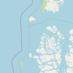
The landscape of Isla Magdalena National Park is defined by the collision of volcanic mountain terrain with the maritime environment of southern Patagonia. The dominant terrain feature is Mentolat Volcano, a volcanic peak reaching 1,660 meters above sea level, which rises as a prominent landmark within the park. The island's interior contains a complex arrangement of mountains, valleys, and forested slopes that descend toward the coastline. The surrounding waters contain numerous smaller islands, with Atilio Island being the most significant among them in the northern portion of the park. The coastline features the typical fjords and inlets of Patagonian geography, where steep terrain meets the sea directly. The combination of high precipitation, cool temperatures, and varied elevation creates a landscape with distinct ecological zones, from coastal shoreline through forest-covered slopes to alpine elevations on the higher peaks.
Isla Magdalena National Park ecosystems, habitats, and plant life
The natural environment of Isla Magdalena National Park exemplifies the Magellanic forest ecosystem that characterizes the southernmost portions of South America. The extremely wet and cool climate supports dense forest growth, with the characteristic species of this ecosystem forming extensive coverage across the island's lower elevations. The annual precipitation of approximately 4,000 millimeters creates conditions favoring moisture-loving plant communities, while the cool temperature range of 6 to 8 degrees Celsius moderates the growing conditions. This combination produces the dense, wet forest character that distinguishes Patagonian wilderness from more northern forest types. The park's island setting and inclusion of multiple smaller islands adds coastal and marine habitat diversity to the terrestrial protected area, creating a more comprehensive ecosystem protection scheme.
Isla Magdalena National Park wildlife and species highlights
While the Wikipedia source provides limited specific information about wildlife species, the Magellanic forest ecosystem of Isla Magdalena National Park is known to support diverse fauna adapted to the wet, cool Patagonian environment. The extensive forest cover provides habitat for numerous bird species, while the marine environments surrounding the island support marine mammals and seabirds. The remote and undeveloped character of the island has allowed wildlife populations to persist with minimal human disturbance. The presence of numerous islands within and adjacent to the park creates a complex coastal environment supporting marine ecosystems. Further detailed wildlife information would require additional source materials beyond the provided Wikipedia entry.
Isla Magdalena National Park conservation status and protection priorities
Isla Magdalena National Park serves as an important protected area within Chile's system of national parks, preserving a representative sample of Patagonian wilderness. The park protects the Magellanic forest ecosystem, a distinctive biome found only in the southernmost portions of South America. The extreme precipitation and cool climate have historically limited human development in this region, allowing extensive natural areas to persist. By protecting Magdalena Island and its surrounding islands, the park preserves not only terrestrial ecosystems but also the coastal and marine environments that intergrade with the island's shoreline. The designation as a national park, following its earlier status as a forest reserve, reflects the recognized conservation importance of this remote Patagonian landscape.
Isla Magdalena National Park cultural meaning and human context
The Wikipedia source does not provide specific information regarding human cultural history or indigenous heritage associated with Isla Magdalena National Park. The extreme weather conditions and remote location of the area likely limited extensive historical human occupation, though the broader Patagonia region has historical connections to indigenous groups including the Mapuche and more southern peoples. The modern access pattern requiring sea travel from communities such as Puerto Cisnes reflects the historical relationship between mainland settlements and this isolated island environment. Any detailed cultural context would require additional source materials beyond the provided information.
Top sights and standout views in Isla Magdalena National Park
The standout features of Isla Magdalena National Park include its remarkable remoteness and wilderness character, the dramatic volcanic peak of Mentolat Volcano rising to 1,660 meters, the extensive Magellanic forest covering the island's lower elevations, and the network of smaller islands adding coastal diversity. The park can only be reached by sea, with Puerto Cisnes and Puerto Puyuhuapi serving as access points, ensuring that visitors experience a genuinely wild and undeveloped landscape. The extreme precipitation and cool climate create an atmospheric environment distinct from more visited Patagonian destinations. Puerto Gaviota in the southern portion of the park is noted as a particularly noteworthy location, while the northern portion contains the significant Atilio island. The absence of any road infrastructure on the island itself preserves its wild character.
Best time to visit Isla Magdalena National Park
The best time to visit Isla Magdalena National Park would typically be during the Patagonian summer months, from December through March, when temperatures are at their warmest and precipitation remains high but daylight hours are longest. However, the extremely wet climate of the region means that visitors should be prepared for rain at any time of year. The cool temperature range of 6 to 8 degrees Celsius requires warm, layered clothing regardless of the season. The sea access requirement means that visit timing is also influenced by sea conditions and boat availability from the mainland ports. Given the lack of infrastructure on the island itself, visitors must be self-sufficient and prepared for backcountry conditions. The remote nature of the park means that visit planning requires careful attention to logistics and weather considerations.