Mori Atlas logo
State or regional parkJilliby State Conservation Area

A diverse bushland landscape featuring rainforest pockets, ridge forests, and critical bird habitats.

Jilliby State Conservation Area: Mapping the Protected Forested Hinterland of New South Wales

Jilliby State Conservation Area sits within the hinterland of the New South Wales Central Coast, offering a protected mosaic of dry forest slopes and sheltered rainforest gullies. The terrain supports high biodiversity, including over 130 recorded bird species, while Muirs Lookout provides vantage points over the dense vegetation. This reserve serves as an essential link in the regional bushland, preserving both natural ecosystems and enduring connections to Aboriginal Country.

state conservation areaCentral Coast NSWeastern Australia bushlandcoastal hinterlandrainforest pocketsbushwalking

Jilliby State Conservation Area

State or regional park

Park overview

Structured park overview, official facts, and landscape profile for Jilliby State Conservation Area

Jilliby State Conservation Area park facts, protected area profile, and essential visitor context

Review the core facts for Jilliby State Conservation Area, including designation, size, terrain, visitor scale, habitats, and operating context in one park-focused overview.

About Jilliby State Conservation Area

Jilliby State Conservation Area is a state-level reserve in New South Wales, Australia, occupying a substantial tract of bushland behind the Central Coast. The conservation area sits within the broader hinterland that runs inland from the populated coastal strip, north of Sydney and west of Newcastle. While the Central Coast is better known for its beaches, lagoons, and waterways, places such as Jilliby State show the region's bushland character, with forests, gullies, and small pockets of rainforest shaped by the often wet conditions of the eastern Australian coastal hinterland.

The area provides a protected setting where visitors can experience a range of natural environments in a single reserve. Its tracks and trails support bushwalking, four-wheel driving, horse riding, and picnicking, making it one of the more versatile recreational bushland areas in the Central Coast region. Rainforest elements, such as those visible from lookout points like Muirs Lookout, contrast with drier forest and open woodland on surrounding ridges, giving the reserve a varied ecological texture within a relatively compact setting.

Jilliby State also has clear cultural significance. The conservation area is recognised as an important cultural and historical site for Aboriginal people in the region, anchoring its natural values within the longer human history of the landscape. Combined with its biodiversity, particularly its substantial birdlife, and its role as an accessible recreation destination near a major regional city, the reserve plays a multi-dimensional role as both a conservation estate and a recreational resource for the Central Coast and Newcastle populations.

Quick facts and research context for Jilliby State Conservation Area

Jilliby State Conservation Area is located in eastern Australia, northwest of the Central Coast in New South Wales and within reach of Newcastle. It is a state-level protected area managed under the NSW National Parks and Wildlife Service framework and is broadly classified as a state conservation area rather than a fully gazetted national park. The reserve covers several thousand hectares of bushland carrying forests and small rainforest remnants, and it sits within the broader Central Coast hinterland landscape north of Sydney.

Protection and recognition

Explore terrestrial protection metrics and official conservation status records

Jilliby State Conservation Area Protection Status and Formal Designation Data

Jilliby State Conservation Area features documented terrestrial protection frameworks and management classifications within its regional landscape. Structured records detail the official conservation scope, administrative history, and international recognition metrics for the protected area.

Protection details

Protection scope
Terrestrial
Transboundary protection
No
Park context

Deeper park guide and search-rich context for Jilliby State Conservation Area

Jilliby State Conservation Area history, landscape, wildlife, and travel context

Explore Jilliby State Conservation Area through its history, landscape character, ecosystems, wildlife, conservation priorities, cultural context, and seasonal travel timing in a structured park guide built for atlas discovery and search intent.

Why Jilliby State Conservation Area stands out

Jilliby State Conservation Area is best known for its combination of accessible bush recreation and rich birdlife in a Central Coast hinterland setting. The reserve features rainforest pockets in otherwise forested terrain, with lookout points such as Muirs Lookout offering views into this greener vegetation. Its bird diversity is a strong part of its identity, with over 130 bird species recorded, making it a recognised destination for birdwatchers as well as walkers, picnickers, and horse riders.
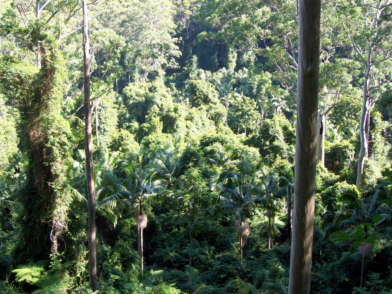
A view of a dense green rainforest with tall tree trunks in the foreground and a thick canopy of trees and palms in the background.
Dense rainforest canopy viewed from Muirs Lookout in Jilliby State Conservation Area.

Jilliby State Conservation Area history and protected-area timeline

The available source notes that Jilliby State Conservation Area holds an important cultural and historical role for Aboriginal people in the region, situating the reserve within the broader Indigenous heritage of the Central Coast hinterland of New South Wales. Beyond this recognition of Aboriginal cultural and historical significance, the source material does not provide further detail on the reserve's specific establishment timeline or management history; that wider historical narrative cannot be supported without additional sources.

Jilliby State Conservation Area landscape and geographic character

The conservation area occupies bushland within the Central Coast hinterland of New South Wales, an inland setting northwest of the densely settled coastal strip. Its terrain carries forests across ridges and slopes, interspersed with sheltered gullies and small rainforest pockets formed under wetter, more sheltered conditions. Lookouts such as Muirs Lookout provide vantage points over these greener, moister vegetation zones, offering a clearer sense of how rainforest persists within an otherwise forested landscape. The area's combination of drier forest on higher ground and rainforest in deeper, sheltered places gives the reserve a physically varied bushland character despite its position behind the coast.

Jilliby State Conservation Area ecosystems, habitats, and plant life

Ecologically, Jilliby State Conservation Area reflects the bushland character of the Central Coast hinterland, where eucalypt-dominated forests meet sheltered gullies capable of supporting rainforest vegetation. The presence of rainforest patches within the broader forest landscape is one of the area's defining ecological features, indicating a degree of moisture and shelter that supports more closed, green forest types than are typical of drier surrounding terrain. The reserve's habitat diversity, from open forest to sheltered rainforest, supports a correspondingly varied wildlife community, with birds being the most prominent and well-documented group.

Jilliby State Conservation Area wildlife and species highlights

The most consistently highlighted wildlife feature of Jillillby State Conservation Area is its birdlife, with more than 130 bird species recorded across the reserve. This level of avian diversity, supported by the mix of forest and rainforest habitats in the Central Coast hinterland, makes the reserve a recognised destination for birdwatchers. Beyond birds, the varied forest and rainforest habitats indicate broader native fauna presence consistent with similar NSW east-coast reserves, though the source does not document specific mammals, reptiles, or other taxa in detail.

Jilliby State Conservation Area conservation status and protection priorities

As a state conservation area in New South Wales, Jilliby State sits within the formal protected-area framework of the state, securing its bushland, rainforest pockets, and associated wildlife from broader land-use pressure in a rapidly growing coastal region. Its recognition as a state conservation area rather than a national park reflects a management intent that balances conservation of natural and cultural values with continued public use for recreation. The presence of over 130 recorded bird species underlines its biodiversity significance within the Central Coast region and identifies it as an important node in the wider network of NSW bushland reserves near Newcastle and the Central Coast.

Jilliby State Conservation Area cultural meaning and human context

Jilliby State Conservation Area is recognised as a place of cultural and historical importance for Aboriginal people in the Central Coast region of New South Wales. This recognition places the reserve within the Indigenous heritage landscape of the area, connecting its natural values to the longer human and cultural history of Country in eastern Australia. The available source does not provide further detail on specific communities, sites, or traditions tied to the reserve, so the deeper cultural narrative cannot be elaborated without additional information.

Top sights and standout views in Jilliby State Conservation Area

Among its standout features, Jilliby State offers a rare mix of rainforest and dry forest habitats in close proximity on the Central Coast hinterland, with lookouts such as Muirs Lookout providing direct views into its rainforest elements. Its birdlife, with over 130 recorded species, gives the reserve a strong identity as a birdwatching destination alongside its other recreational uses. Combined with its accessibility from Newcastle and the Central Coast and its recognised Aboriginal cultural importance, the conservation area offers both natural and cultural points of interest within a single protected landscape.

Best time to visit Jilliby State Conservation Area

Because Jilliby State Conservation Area features both drier forest and sheltered rainforest pockets on the Central Coast hinterland, cooler and wetter months tend to bring out the lushness of its rainforest vegetation and may support more active birdlife, while warmer months remain suitable for bushwalking and picnicking on drier, more open forest areas. As always in eastern Australia, conditions can vary and visitors should consider local weather when planning time on tracks and trails.

Monthly climate preview

Long-term representative temperature and precipitation rhythms across twelve months

Jilliby State Conservation Area Climate Normals and Annual Weather Patterns

Measured coordinates track monthly thermal ranges alongside daily precipitation averages from historical NASA climate records. Examining full seasonal shifts reveals foundational meteorological trends across protected terrain.
Annual mean17 °C
10 °C24 °C
Jan24°
Feb23°
Mar21°
Apr18°
May14°
Jun11°
Jul10°
Aug12°
Sep15°
Oct18°
Nov20°
Dec22°
Warmest month
January

23.9 °C

Coolest month
July

10.4 °C

Wettest month
February

4.1 mm/day

Driest month
August

1.4 mm/day

Park location guide

Geography guide, regional context, and park location map for Jilliby State Conservation Area

Jilliby State Conservation Area park geography, regions, and map view in Australia

Understand where Jilliby State Conservation Area sits in Australia through a broader geographic reading of the surrounding landscape, nearby location context, and its mapped position within the national park landscape.

How Jilliby State Conservation Area fits into Australia

Australia is a constitutional monarchy and federal parliamentary democracy comprising six states and ten territories. With a population of nearly 28 million, it is one of the world's most urbanised countries, with most people concentrated on the eastern seaboard. The country has a high Human Development Index and is known for its cultural diversity, ancient Aboriginal heritage, and unique wildlife.

Wider geography shaping Jilliby State Conservation Area in Australia

Australia occupies the entire Australian continent, the island of Tasmania, and numerous smaller islands. It is the world's flattest and driest inhabited continent, featuring vast deserts in the interior (the Outback), tropical rainforests along the eastern coast, and a coastline bordering the Indian and Pacific Oceans.

Map view of Jilliby State Conservation Area

Use this park location map to pinpoint Jilliby State Conservation Area in Australia, understand its exact geographic position, and read its mapped placement within the surrounding landscape more clearly.

Pigeon | © OpenStreetMap contributors

Location context for Jilliby State Conservation Area

New South Wales
Recorded earthquake history

Review Historical Seismic Records for Jilliby State Conservation Area

Examine the recorded history of seismic events associated with the surrounding terrain of Jilliby State Conservation Area. MoriAtlas provides a searchable catalogue of historical earthquake data, helping users gain insight into the regional seismic profile of this Central Coast bushland destination.

Jilliby State Conservation Area Earthquake History

Catalogued events

4 events

Strongest magnitude

Magnitude 5.4

Most recent event

Apr 22, 2025

This history includes earthquakes recorded inside the park or within 50 km of its borders

Visual reference of forested ridges, sheltered rainforest pockets, and regional hinterland habitats

Jilliby State Conservation Area Photos, Landscape Scenery, and Protected Terrain Views

Visual records capture the varied terrain and protected landscape character of Jilliby State Conservation Area across forested ridges and sheltered gullies. Photographic documentation reveals the underlying habitats and scenic lookouts that define the eastern Australia bushland setting.

A view of a dense green rainforest with tall tree trunks in the foreground and a thick canopy of trees and palms in the background.

Park atlas

Compare nearby national parks and regional bushland reserves across the Central Coast hinterland.

Parks Near Jilliby State Conservation Area And Surrounding Protected Landscapes

Browse protected areas and forested reserves located close to Jilliby State Conservation Area. Compare surrounding regional landscapes to understand the broader network of natural habitats in the hinterland.
National parkNew South Wales
Park boundaries overlap#1 closest

North

Watagans National Park: National Park Protected Landscape in New South Wales

Explore its mapped boundaries and regional geography.

Watagans National Park stands as a key protected area within New South Wales, Australia. This detail page focuses on its specific role as a national park, offering insights into its mapped geographic boundaries and its place within the regional landscape. Understand the protected natural identity of Watagans National Park through a structured, atlas-informed lens.

Area
77.51 km²
Established
1999
IUCN
II
Climate
Temperate
National parkNew South Wales
2.5 km away#2 closest

Southwest

Popran National Park National Park: A Protected Landscape Atlas in New South Wales

Explore the valley terrain and Aboriginal heritage of this protected natural area.

Popran National Park in New South Wales is a significant protected national park offering rich insights into Australia's natural and cultural heritage. This park preserves the unique valley landscapes of the Popran Creek catchment and the historically important Glenworth Valley. Its geography reflects the broader Sydney basin, with terrain averaging 135 metres in elevation, showcasing riparian ecosystems and eucalyptus forests. The park's protected status ensures the conservation of this distinctive landscape, making it a key point of interest for geographic discovery and understanding regional Australian protected areas.

Area
39.7 km²
Established
1994
IUCN
II
Relief
Upland
National parkNew South Wales
2.9 km away#3 closest

South

Brisbane Water National Park: A Protected Landscape in New South Wales' Sydney Basin Bioregion

Explore mapped terrain, endangered ecosystems, and coastal waterway geography.

Brisbane Water National Park, located in New South Wales, Australia, is a vital protected area safeguarding critical ecosystems within the Sydney Basin bioregion. This national park features a diverse landscape encompassing rugged escarpments, fertile valleys, and important coastal waterways. Its protected status makes it a crucial conservation refuge, offering insights into unique natural terrain and regional geography for those seeking detailed, map-centric exploration.

Area
115.06 km²
Established
1959
IUCN
II
Relief
Mixed relief
Protected areaNew South Wales
10 km away#4 closest

East

Lake Macquarie State Conservation Area: Geography and Protected Landscape Map Details

Coastal lagoon bushland across six protected foreshore sections

Situated along the saltwater shores of a major coastal lagoon in New South Wales, this protected area features a distinctive fragmented design. The reserve safeguards rare coastal forest and wetland vegetation, providing a vital snapshot of the region's original shoreline ecosystem. Through its unique distribution of six shoreline blocks, the park offers significant insight into the interplay between protected bushland and the surrounding developed landscape.

Area
7.6 km²
Established
1996
IUCN
II
Scope
Terrestrial
Watercolor illustration depicting a landscape with hills in the background, green vegetation in the foreground, and a body of water in the middle ground
National parkNew South Wales
11 km away#5 closest

Southwest

Dharug National Park: New South Wales Protected Area and Historic Landscape Exploration

Mapped terrain and convict-era infrastructure on the Hornsby Plateau.

Dharug National Park stands as a significant protected landscape within New South Wales, situated on the northern margin of the Sydney Basin. The park's geography features rolling forested terrain and valleys carved into ancient Permian and Triassic sedimentary rocks. Its protected status ensures the preservation of key sections of the Old Great North Road, a World Heritage site, offering a unique blend of natural geography and colonial history for atlas-based discovery.

Area
148.5 km²
Established
1967
IUCN
II
Relief
Mixed relief
National parkNew South Wales
13 km away#6 closest

Southeast

Wyrrabalong National Park National Park: Protected Littoral Rainforest and Coastal Geography

Explore mapped terrain and vital bird habitats in New South Wales.

Wyrrabalong National Park on New South Wales' Central Coast is an essential protected landscape, noted for safeguarding the last significant coastal littoral rainforest of its kind. This park entry details the mapped geography across its peninsula, island, and beachfront sections, revealing a compact yet ecologically rich environment. It highlights the park's importance as part of an Important Bird Area, supporting significant waterbird and woodland bird populations within its protected boundaries, offering a unique glimpse into a vanishing coastal ecosystem.

Area
6.2 km²
Established
1991
IUCN
II
Relief
Lowland
National parkNew South Wales
13 km away#7 closest

West

Yengo National Park: Protected Landscape Identity and Geographic Context

Explore its mapped terrain and wilderness character.

Yengo National Park in New South Wales, Australia, is a vast protected area known for its remote wilderness character and significant geographical landmarks such as Mount Yengo. As a vital part of the Greater Blue Mountains World Heritage Site, the park showcases rugged mountainous terrain and diverse natural landscapes. This entry focuses on its atlas-value, detailing the park's mapped boundaries, regional geography, and its identity as a significant protected landscape for nature exploration.

Area
1,543.28 km²
Established
1988
IUCN
Ib
Relief
Mountain
Watercolor painting depicting a coastal landscape with green hills, sandy beach, and pink and green plants in the foreground
National parkNew South Wales
17 km away#8 closest

South

Bouddi National Park: Coastal National Park with Temperate Rainforest & Marine Atlas

Discover unique sandstone landscapes and protected marine geography in New South Wales.

Bouddi National Park in New South Wales stands out for its rare mix of coastal headlands, ancient temperate rainforests, and a comprehensive marine protected area. Its landscape is defined by dramatic Hawkesbury sandstone geology, featuring spectacular tessellated pavements and laterite plateaus. The park's protected marine zone significantly enhances local biodiversity, making it a key area for understanding coastal and oceanic protected landscapes within the Australian atlas.

Area
15.32 km²
Established
1967
IUCN
II
Relief
Lowland

Common questions about visiting, size, designation, and location context for Jilliby State Conservation Area

Jilliby State Conservation Area FAQs for park facts, access, geography, and protected area context

Find quick answers about Jilliby State Conservation Area, including protected-area facts, park geography, trail and visitor context, and how the park fits into its surrounding country and regional landscape.
MoriAtlas Explorer

Continue Your Protected Areas Search Across the Global Atlas

Deepen your exploration by continuing the structured search for national parks and protected areas worldwide. Utilize the comprehensive filtering capabilities to compare different conservation landscapes and refine your understanding of global park geography. Discover more about the distribution and characteristics of protected natural areas.

Global natural geography