

Mori Atlas logo
National parkJirisan National Park

Discover the mapped boundaries and regional landscape context of Jirisan National Park.

Jirisan National Park: South Korea's Protected National Park Geography and Map Atlas

(지리산국립공원 (Jirisan National Park))

Jirisan National Park stands as a significant protected national park within South Korea, offering a unique vantage point for exploring the country's diverse geography. This detailed entry provides essential context for understanding its protected landscape identity, mapped terrain, and place within the broader atlas of East Asian natural areas. Examine its boundaries and discover how this key protected zone contributes to the regional geography of the Korean Peninsula.

National ParkMountain LandscapeWildlife ConservationOld-Growth ForestAsiatic Black BearBuddhist Heritage

Jirisan National Park

National park

Park overview

Structured park overview, official facts, and landscape profile for Jirisan National Park

Jirisan National Park park facts, protected area profile, and essential visitor context
Review the core facts for Jirisan National Park, including designation, size, terrain, visitor scale, habitats, and operating context in one park-focused overview.

About Jirisan National Park

Jirisan National Park represents the crown jewel of South Korea's protected area system, established as the nation's first national park in 1967 and remaining its largest terrestrial conservation designation. The park encompasses a complex mountainous landscape dominated by the peak of Jirisan, also known by its Buddhist name of JLSan, which has been considered a sacred mountain in Korean Buddhism for more than a millennium. The park's boundaries traverse three provinces, creating a remarkable ecological corridor that connects diverse regional ecosystems and provides critical habitat for species ranging from subtropical flora in the lower valleys to subalpine communities near the summits. The Korea National Park Service maintains extensive trail infrastructure throughout the park, with well-maintained pathways ranging from gentle forest walks to challenging summit treks that attract hikers throughout the year. Visitor facilities include interpretation centers, camping areas, and ranger stations that help manage the relationship between public access and conservation objectives. The park's management philosophy emphasizes both biodiversity protection and the restoration of degraded ecosystems, with particular success in recovering forest cover in areas that suffered from historical overuse.

Quick facts and research context for Jirisan National Park

Jirisan National Park covers 471.75 square kilometers in southwestern South Korea, making it the nation's largest land-based national park. It was established on December 29, 1967 as the first of South Korea's twenty-two national parks. The park spans three provinces and borders the towns of Namwon, Gurye, and Hamyang. The park receives approximately 1.5 million visitors annually and is managed by the Korea National Park Service. The highest peak is Cheongwangdae at 1,915 meters, though the mountain is commonly referred to by its sacred name Jirisan.

Park context

Deeper park guide and search-rich context for Jirisan National Park

Jirisan National Park history, landscape, wildlife, and travel context
Explore Jirisan National Park through its history, landscape character, ecosystems, wildlife, conservation priorities, cultural context, and seasonal travel timing in a structured park guide built for atlas discovery and search intent.

Why Jirisan National Park stands out

Jirisan National Park is best known for its pioneering wildlife conservation programs, particularly the successful recovery of the Asiatic black bear population through intensive protection and habitat management. The park's extensive old-growth forests, deep river valleys, and diverse elevation gradients support a remarkable range of habitats from subtropical woodland at lower elevations to subalpine zones near the summits. The mountain has been an important center of Buddhist heritage for over a thousand years, home to numerous historic temples including Hwaeomsa, one of Korea's most significant Buddhist monasteries. Jirisan is also recognized for its ecological restoration efforts on areas previously damaged by human activity, serving as a model for degraded landscape recovery in East Asia.

Jirisan National Park history and protected-area timeline

Jirisan National Park was established on December 29, 1967, becoming South Korea's first national park and initiating the nation's modern protected area system. The designation came at a critical time when Korea was experiencing rapid economic development and increasing pressure on natural landscapes. Prior to national park status, the mountain had already accumulated centuries of religious and cultural significance, with Buddhist temples establishing presence in the valleys and slopes starting around the 7th century. The establishment of the park provided legal protection for the mountain's forests and wildlife, though early management focused primarily on preventing commercial exploitation and managing visitor access. In the decades following establishment, the park became the focal point for South Korea's most ambitious wildlife conservation initiatives, particularly the Asiatic black bear recovery program that began in the 1990s. This program involved strict anti-poaching measures, habitat enhancement, and a carefully managed reintroduction strategy that successfully reestablished a viable bear population. The park has also pioneered ecological restoration techniques to recover areas that suffered degradation from historical logging, agriculture, and visitor impact.

Jirisan National Park landscape and geographic character

Jirisan National Park protects a spectacular mountainous landscape characterized by dramatic ridgelines, deep V-shaped valleys, and numerous streams that descend from the high peaks toward the surrounding lowlands. The park's terrain rises from approximately 300 meters above sea level in the lower valleys to 1,915 meters at Cheongwangdae, the highest peak, creating substantial ecological zonation across relatively short horizontal distances. The mountain's geology consists primarily of ancient granite and metamorphic rocks that have been shaped by millions of years of erosion, resulting in the formation of distinctive rock formations, waterfalls, and precipitous cliffs. The Seomjin River and its tributaries have carved deep valleys through the park, creating riparian corridors that serve as crucial wildlife movement pathways. The landscape varies significantly with elevation, transitioning from broadleaf deciduous forests in the lower reaches through mixed deciduous-coniferous forests in middle elevations to coniferous forests and alpine meadows near the summit. The park contains several distinct scenic areas, including the Hwaeomsa valley, the Baemsagol valley, and the ridge-top trail between the main peaks.

Jirisan National Park ecosystems, habitats, and plant life

Jirisan National Park supports exceptional ecological diversity due to its location at the intersection of multiple biogeographic regions and its dramatic topographical variation. The park contains more than 1,000 plant species, representing a remarkable cross-section of Korean flora from subtropical species in the warm valleys to subalpine species adapted to the harsh conditions near the summit. The forest ecosystem is particularly significant, with substantial old-growth areas that have never been logged supporting mature trees of numerous species including Korean pine, Korean fir, and various oak species. The park's streams and rivers maintain cold, well-oxygenated waters that support native fish species and provide critical habitat for freshwater organisms. The ecological significance of the park extends to its role as a biodiversity refuge in a region where much of the original forest cover has been converted to agriculture or urban development. The varied aspects of the mountain's slopes create diverse microclimates that support species with different moisture and temperature requirements, contributing to the park's overall ecological richness.

Jirisan National Park wildlife and species highlights

Jirisan National Park is renowned for its successful Asiatic black bear conservation program, which stands as one of the most notable wildlife recovery achievements in East Asia. The bear population, which had been driven to near-extinction by hunting and habitat loss, has recovered to approximately 50 individuals through intensive protection, anti-poaching efforts, and habitat management. The park also supports populations of other significant mammals including Korean serow, a protected ungulate species that inhabits the rocky cliffs and forested slopes, as well as various species of deer and small mammals. The bird fauna includes numerous species of songbirds, woodpeckers, and raptors that utilize the diverse forest habitats. The park's streams contain native fish species including masu salmon and various cyprinids that require clean, well-oxygenated water. The combination of protected habitat, management intervention, and ecological diversity has made Jirisan a model for wildlife conservation in mountainous protected areas across the region.

Jirisan National Park conservation status and protection priorities

Jirisan National Park serves as South Korea's flagship conservation area, demonstrating successful approaches to wildlife recovery and ecosystem restoration. The park's Asiatic black bear program represents a landmark conservation achievement, demonstrating how dedicated protection, community engagement, and scientific management can recover endangered populations from the brink of local extinction. Beyond the charismatic megafauna, the park protects significant forest ecosystems that serve as carbon sinks, watersheds for downstream communities, and refuges for numerous species of conservation concern. The park's restoration program has developed innovative techniques for recovering degraded forest ecosystems, using native species and natural regeneration processes to restore ecological function to areas previously impacted by human activity. Management priorities include maintaining the integrity of critical habitat corridors, controlling invasive species, and balancing public access with conservation objectives. The park also serves as an outdoor laboratory for ecological research and environmental education, hosting scientific studies and visitor programs that advance conservation understanding.

Jirisan National Park cultural meaning and human context

Jirisan has been a significant site of Korean Buddhist practice and cultural heritage for over a thousand years, with temples and monastic communities establishing presence on the mountain's slopes beginning in the Silla Dynasty. Hwaeomsa Temple, founded in the 7th century and rebuilt in its current form during the Joseon Dynasty, remains one of the most important Buddhist monasteries in Korea, housing significant cultural artifacts and continuing active religious practice. The mountain's name itself reflects this spiritual heritage, as Jirisan means literally the sacred mountain of wisdom and virtue in Korean. Traditional pilgrimage routes traverse the park, connecting temples and sacred sites in a network of trails that have been used by monks and devotees for centuries. The surrounding rural communities maintain cultural connections to the mountain, with local traditions and practices that reflect the historical relationship between human settlement and the natural landscape. The park's cultural landscape demonstrates the integration of natural and spiritual values that characterizes traditional Korean approaches to mountain environments.

Top sights and standout views in Jirisan National Park

Jirisan National Park offers visitors multiple outstanding experiences, from the spiritual grandeur of Hwaeomsa Temple with its ancient gates and traditional architecture to the challenging but rewarding summit hike that rewards hikers with panoramic views across the park's forested ridgelines. The bear observation program provides rare opportunities to view Asiatic black bears in the wild through guided tours operated by the Korea National Park Service. The park's trail network includes options for all fitness levels, from gentle valley walks following the Seomjin River to multi-day traverses of the main ridge. The autumn foliage season transforms the mountain into a spectacular display of red and gold, while spring brings carpeted forests of wildflowers and blooming rhododendrons. Winter snow creates a different but equally compelling landscape, with frozen waterfalls and snow-covered peaks offering serene backcountry skiing and climbing opportunities for experienced adventurers.

Best time to visit Jirisan National Park

Jirisan National Park offers distinctive experiences throughout the year, with each season bringing different characters and opportunities. Spring from April to May brings mild temperatures, blooming rhododendrons, and the fresh green of new foliage, making it ideal for hiking and wildlife viewing as animals become more active. Summer months can be warm and humid but provide access to the high-elevation trails and cool forest shade. Autumn from mid-September to November offers perhaps the most spectacular scenery as the deciduous forests display vivid fall colors, though this is also the most popular season for visitors. Winter from December to February transforms the landscape with snow on the higher peaks and provides peaceful solitude for those comfortable with cold conditions, though some trails may be closed or require caution. The park can be visited year-round, though spring and autumn generally offer the most comfortable conditions and the most visually striking landscapes.
Park location guide

Geography guide, regional context, and park location map for Jirisan National Park

Jirisan National Park park geography, regions, and map view in South Korea
Understand where Jirisan National Park sits in South Korea through a broader geographic reading of the surrounding landscape, nearby location context, and its mapped position within the national park landscape.

How Jirisan National Park fits into South Korea

South Korea is a presidential republic on the Korean Peninsula in East Asia. It has a population of about 51 million and Seoul as its capital and largest city. The country is known for its rapid economic development, high technology industry, and cultural exports.

Wider geography shaping Jirisan National Park in South Korea

South Korea occupies the southern half of the Korean Peninsula in East Asia. It borders North Korea along the Demilitarized Zone to the north, the Yellow Sea to the west, and the Sea of Japan to the east. The terrain is predominantly mountainous with coastal plains along the southern and eastern shores.

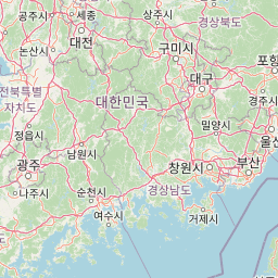
Map view of Jirisan National Park

Use this park location map to pinpoint Jirisan National Park in South Korea, understand its exact geographic position, and read its mapped placement within the surrounding landscape more clearly.

Pigeon | © OpenStreetMap contributors

Location context for Jirisan National Park

Gyeongsangnam-doJeollabuk-doJeollanam-do
Park atlas

Browse a curated atlas of nearby protected landscapes, compare their unique geographies, and trace their regional spread.

Continue Park Exploration: Discover Related National Parks and Protected Areas Near Jirisan National Park
Explore other national parks and protected areas situated in the mountainous southwestern region of the Korean Peninsula, expanding your geographic perspective beyond Jirisan National Park. Compare varied park landscapes, trace the regional distribution of protected mountain terrain, and map the spread of diverse conservation efforts in East Asia.
National parkJeollanam-do

Mudeungsan National Park: Mapped Protected Landscape and Regional Geography Context

Explore Mudeungsan National Park's geographic setting in Jeollanam-do.

Mudeungsan National Park offers a distinct protected landscape within the Jeollanam-do region of South Korea. This atlas-focused page details its mapped geographic boundaries and the surrounding natural terrain, providing essential context for understanding its role as a national park. Explore the park's identity through its unique landscape and regional geography.

Area
75.45 km²
Established
2012
IUCN
II
Relief
Mountain
National parkJeollabuk-do

Deogyusan National Park: National Park Identity and Geographic Mapping

Explore its protected land boundaries and regional landscape context.

Examine Deogyusan National Park, a designated national park situated in the Jeollabuk-do region of South Korea. This entry provides critical geographic context, focusing on the park's mapped boundaries and its role as a protected landscape. Users can gain a structured understanding of its natural terrain and regional significance, contributing to a broader atlas of protected areas.

Area
231.65 km²
Established
1975
IUCN
V
Visitors
1M annual
National parkSouth Korea

Hallyeohaesang National Park: South Korea National Park Geographic Atlas Entry

Explore mapped protected area boundaries and natural terrain.

As a designated national park in South Korea, Hallyeohaesang National Park offers a distinct geographic profile crucial for atlas exploration. This entry focuses on its protected landscape features, mapped territorial extent, and regional context within the Republic of Korea. Understand the park's specific geographical markers and its significance as a mapped protected area.

Area
545.63 km²
Established
1968
IUCN
II
Access
Access unknown
National parkSouth Korea

Naejangsan National Park: South Korea's Mapped Protected Landscape and Geography

Discover the park's protected boundaries and regional context.

Investigate Naejangsan National Park, a protected area within South Korea, through its mapped geography and landscape context. This detailed atlas entry provides insight into the park's specific geographic identity and its role as a national park, offering a structured understanding of its protected natural features for focused exploration and research.

Area
81.45 km²
Established
1971
IUCN
II
Relief
Mountain
National parkSouth Gyeongsang Province

Gayasan National Park: National Park Identity and Mapped Geographic Context in South Korea

Discover Protected Landscape and Regional Terrain

Gayasan National Park presents a distinct protected-area entity within South Gyeongsang Province, serving as a crucial point for atlas-driven geographic exploration. As a designated national park in South Korea, it offers insights into its specific mapped boundaries and the surrounding natural terrain. Understanding this park's role within the regional geography provides a foundational element for comprehending broader landscape patterns and protected land distribution across the country.

Area
167.6 km²
Established
1972
IUCN
II
Relief
Mountain
National parkJeollabuk-do

Byeonsan-bando National Park: Protected Landscape and Geographic Context in Jeollabuk-do

Explore mapped terrain and regional park geography.

This detail page provides an in-depth look at Byeonsan-bando National Park, a protected area located in South Korea's Jeollabuk-do region. Users can discover the park's specific geographic identity, understand its mapped boundaries, and explore its role within the broader regional landscape. The content is structured for atlas exploration, offering detailed insights into the park's natural terrain and its significance as a national park.

Area
154.71 km²
Established
1988
IUCN
II
Relief
Mixed relief
National parkJeollanam-do

Wolchulsan National Park: Detailed Geographic and Protected Landscape Atlas Entry

Explore mapped boundaries and natural terrain context.

This MoriAtlas entry for Wolchulsan National Park provides a detailed look at its identity as a protected landscape within Jeollanam-do, South Korea. Focus is placed on its geographic context and mapped park boundaries, offering a foundation for understanding its place in the regional atlas. Discover the structured details of this national park's natural terrain and its significance as a preserved natural area.

Area
56.6 km²
Established
1988
IUCN
II
Relief
Mountain
National parkChungcheongnam-do

Gyeryongsan National Park: Mapped Protected Landscape in Chungcheongnam-do

Explore its national park designation and regional geography.

Gyeryongsan National Park is a formally protected national park in Chungcheongnam-do, South Korea. This page offers critical atlas context for understanding the park's geographic scope, mapped protected boundaries, and its significance as a natural landscape within the region. Examine the terrain and explore its regional context for a deeper appreciation of its protected status.

Area
64.71 km²
Established
1968
IUCN
II
Relief
Mountain

Common questions about visiting, size, designation, and location context for Jirisan National Park

Jirisan National Park FAQs for park facts, access, geography, and protected area context
Find quick answers about Jirisan National Park, including protected-area facts, park geography, trail and visitor context, and how the park fits into its surrounding country and regional landscape.
MoriAtlas Explorer

Continue Your Protected Areas Search Across the Global Atlas

Deepen your exploration by continuing the structured search for national parks and protected areas worldwide. Utilize the comprehensive filtering capabilities to compare different conservation landscapes and refine your understanding of global park geography. Discover more about the distribution and characteristics of protected natural areas.

Global natural geography