Mori Atlas logo
National parkJuan Crisóstomo Falcón National Park

Mapping the protected boundaries and distinct natural terrain of this Venezuelan national park.

Juan Crisóstomo Falcón National Park: Venezuela National Park Map and Protected Landscape Geography

(Juan Crisóstomo Falcón en la Sierra de San Luis National Park)

Juan Crisóstomo Falcón National Park stands as a significant protected area within Venezuela, offering users a dedicated space for geographic exploration. This page provides critical atlas context for the park's mapped boundaries, its place within the regional geography of northern South America, and the distinct natural terrain it encompasses. Understand the park as a key element in the broader landscape of Venezuela's protected lands, ideal for detailed map-based discovery.

national parkVenezuelaprotected areaSierra de San Luis

Juan Crisóstomo Falcón National Park

National park

Park overview

Structured park overview, official facts, and landscape profile for Juan Crisóstomo Falcón National Park

Juan Crisóstomo Falcón National Park park facts, protected area profile, and essential visitor context

Review the core facts for Juan Crisóstomo Falcón National Park, including designation, size, terrain, visitor scale, habitats, and operating context in one park-focused overview.
Monthly climate preview

Long-term representative temperature and precipitation rhythm across twelve months

Juan Crisóstomo Falcón National Park Climate Normals and Weather by Month

Representative coordinate records for Juan Crisóstomo Falcón National Park show sustained monthly mean temperatures alongside distinct shifts in average precipitation normals. Examining the complete twelve-month temperature and precipitation profile provides deeper insight into long-term meteorological patterns.
Annual mean27 °C
26 °C28 °C
Jan26°
Feb26°
Mar27°
Apr28°
May28°
Jun28°
Jul28°
Aug28°
Sep28°
Oct27°
Nov26°
Dec26°
Warmest month
August

28 °C

Coolest month
December

25.5 °C

Wettest month
October

3.6 mm/day

Driest month
February

0.5 mm/day

Park location guide

Geography guide, regional context, and park location map for Juan Crisóstomo Falcón National Park

Juan Crisóstomo Falcón National Park park geography, regions, and map view in Venezuela

Understand where Juan Crisóstomo Falcón National Park sits in Venezuela through a broader geographic reading of the surrounding landscape, nearby location context, and its mapped position within the national park landscape.

How Juan Crisóstomo Falcón National Park fits into Venezuela

Venezuela is a country in northern South America with coastline along the Caribbean Sea and Atlantic Ocean. It borders Colombia, Brazil, Guyana, and Trinidad and Tobago. The country has an area of approximately 916,445 km² and a population of about 31.8 million. Caracas is the capital and largest city. Venezuela consists of 23 states and the Capital District.

Wider geography shaping Juan Crisóstomo Falcón National Park in Venezuela

Venezuela is located on the northern coast of South America. The continental territory is bordered by the Caribbean Sea and Atlantic Ocean to the north, Colombia to the west, Brazil to the south, and Guyana to the east. Trinidad and Tobago lies to the northeast. The country includes various islands and islets in the Caribbean Sea known as the Federal Dependencies.

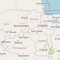
Map view of Juan Crisóstomo Falcón National Park

Use this park location map to pinpoint Juan Crisóstomo Falcón National Park in Venezuela, understand its exact geographic position, and read its mapped placement within the surrounding landscape more clearly.

Pigeon | © OpenStreetMap contributors
Park atlas

Compare Venezuela's diverse protected landscapes, including regions surrounding Sierra de San Luis and Juan Crisóstomo Falcón National Park

Discover Other National Parks and Protected Areas Near Juan Crisóstomo Falcón National Park

Browse other national parks and protected areas in Venezuela that share regional proximity or similar conservation goals with Juan Crisóstomo Falcón National Park, offering detailed geographic context. Deepen your understanding of Venezuela's protected landscapes by comparing their mapped locations, ecological characteristics, and unique conservation profiles.
National parkFalcón
About 0 km away#1 closest

Northwest

Parque nacional Juan Crisóstomo Falcón: Karst Geology and Sierra de Falcón Geography

Protected karst mountains, cave systems, and water networks in northern Venezuela.

Parque nacional Juan Crisóstomo Falcón encompasses a distinct limestone landscape within the Sierra de Falcón. This protected area is recognized for vertical sinkholes, sprawling subterranean galleries, and the Fosa de San Luis. As a key water source for the region, the park presents a compact mosaic of varied mountain terrain, encompassing both cloud forest and arid woodland zones across its mountainous expanse.

Area
200 km²
Established
1987
IUCN
II
Relief
Mountain
National parkFalcón State
About 26 km away#2 closest

North

Médanos de Coro National Park: Venezuela's Unique Arid Landscape and Protected Dune System

Explore the mapped geography of this coastal desert in Falcón State.

Médanos de Coro National Park represents a remarkable protected area within Venezuela's Falcón State, renowned for its spectacular and active sand dune systems. This national park encompasses approximately 91 square kilometers of unique terrain, including large sand formations, salt marshes, and mangrove swamps, contributing to its designation as a key conservation site for arid coastal ecosystems. Users can explore the park's distinctive landscape, understand its geographic context, and discover the patterns of wind-sculpted dunes that define this Venezuelan national park.

Area
91 km²
Established
1974
IUCN
II
Relief
Lowland
National parkVenezuela
About 82 km away#3 closest

Southeast

Cueva de la Quebrada del Toro National Park: Venezuelan National Park Protected Landscape

Explore its mapped boundaries and regional geographic context.

This page details Cueva de la Quebrada del Toro National Park, highlighting its status as a national park within Venezuela. Understand the park's geographic setting, its role as a protected landscape, and its mapped presence within the country's natural reserves. It provides essential context for exploring its protected boundaries and regional significance for atlas-based discovery.

Area
48.85 km²
Established
1961
IUCN
II
Relief
Upland
National parkLara State
About 107 km away#4 closest

South

Cerro Saroche National Park: A National Park within Lara State's Geography

Explore the protected landscape and mapped boundaries.

Cerro Saroche National Park in Lara State, Venezuela, is a distinct protected area offering a valuable perspective for geographic and atlas exploration. This page provides essential details about its identity as a national park, highlighting its place within the regional landscape. Understanding Cerro Saroche National Park helps in appreciating the distribution of protected lands and their geographical significance across Venezuela.

Area
322.94 km²
Established
1989
IUCN
II
Relief
Mountain
National parkVenezuela
About 137 km away#5 closest

Southeast

Yurubí National Park: A National Park in Venezuela for Protected Landscape Exploration

Explore mapped boundaries and regional geography.

Yurubí National Park represents a distinct protected area within Venezuela, offering valuable data for geographic exploration and atlas-based understanding. This national park's identity is defined by its mapped boundaries and its role in the regional landscape context of northern South America. Delve into its protected territory to gain insights into Venezuela's natural geography and conservation landscapes.

Area
236.7 km²
Established
1960
IUCN
II
Relief
Mountain
Watercolor painting of a landscape featuring green trees, hills, and cacti under a light blue sky
National parkCuracao
About 145 km away#6 closest

Northeast

Christoffelpark National Park: Curacao's Volcanic Terrain and Protected Landscape Atlas

Explore mapped boundaries and unique dry forest ecosystems.

Christoffelpark represents Curacao's most vital protected natural area, offering a deep dive into its unique geography and landscape. This national park preserves the island's highest peak, Christoffelberg, alongside distinctive dry forest ecosystems, endemic species, and the remnants of colonial plantations. Explore the mapped terrain, understand the regional context, and appreciate the rich natural and cultural heritage that defines this important protected landscape on Curacao.

Area
10.4 km²
Established
1978
IUCN
II
Relief
Mixed relief
National parkVenezuela
About 145 km away#7 closest

East

Morrocoy National Park: Venezuela's Coastal National Park with Distinct Protected Geography

Explore the mapped protected landscape and regional context.

Morrocoy National Park stands as a key protected area within Venezuela, offering a distinct focus for geographic exploration. As a national park, its mapped boundaries delineate a significant natural landscape critical for understanding regional conservation and the country's broader atlas of protected lands. Discover the unique geographic characteristics and the atlas-driven context of this important Venezuelan protected area.

Area
320.9 km²
Established
1974
IUCN
II
Relief
Mixed relief
National parkVenezuela
About 149 km away#8 closest

South

Terepaima National Park: Venezuela's National Park Protected Landscape

Mapped Boundaries and Regional Geography

Terepaima National Park is a designated national park within Venezuela, offering a clear focus for atlas-driven exploration of protected natural areas. This entry highlights the park's significance as a mapped protected landscape, providing essential geographic context and detail for understanding its boundaries and regional setting. It is an integral component for any structured discovery of Venezuela's conservation network.

Area
186.5 km²
Established
1976
IUCN
II
Relief
Mountain

Common questions about visiting, size, designation, and location context for Juan Crisóstomo Falcón National Park

Juan Crisóstomo Falcón National Park FAQs for park facts, access, geography, and protected area context

Find quick answers about Juan Crisóstomo Falcón National Park, including protected-area facts, park geography, trail and visitor context, and how the park fits into its surrounding country and regional landscape.
MoriAtlas Explorer

Continue Your Protected Areas Search Across the Global Atlas

Deepen your exploration by continuing the structured search for national parks and protected areas worldwide. Utilize the comprehensive filtering capabilities to compare different conservation landscapes and refine your understanding of global park geography. Discover more about the distribution and characteristics of protected natural areas.

Global natural geography