

Mori Atlas logo
Nature reserveKachemak Bay National Estuarine Research Reserve

A comprehensive look at the largest estuarine research reserve within the federal system.

Kachemak Bay National Estuarine Research Reserve: Mapping Alaska Coastal Protected Landscapes

Kachemak Bay National Estuarine Research Reserve encompasses over 370,000 acres of protected coastal terrain on the Kenai Peninsula in southern Alaska. This vast landscape integrates marine environments, intertidal flats, and dense coastal forests into a single management framework. By tracing the watershed from upland catchments to rocky reefs, the reserve serves as a critical site for monitoring the interaction between high-latitude ecosystems and regional human activity.

estuarine reserveAlaska coastKenai PeninsulaGulf of Alaskaintertidal flatseelgrass beds

Kachemak Bay National Estuarine Research Reserve

Nature reserve

Park overview

Structured park overview, official facts, and landscape profile for Kachemak Bay National Estuarine Research Reserve

Kachemak Bay National Estuarine Research Reserve park facts, protected area profile, and essential visitor context

Review the core facts for Kachemak Bay National Estuarine Research Reserve, including designation, size, terrain, visitor scale, habitats, and operating context in one park-focused overview.

About Kachemak Bay National Estuarine Research Reserve

Kachemak Bay National Estuarine Research Reserve occupies the western side of the Kenai Peninsula, where steep forested mountains meet the sheltered waters of Kachemak Bay on the Gulf of Alaska. The reserve's more than 370,000 acres encompass tidal flats, eelgrass beds, estuarine channels, rocky shores, coastal wetlands, freshwater streams, and the surrounding maritime forests. This convergence of habitats within a single boundary makes the bay an unusually rich site for studying estuarine ecology in a cold, subarctic setting.

A defining strength of the reserve is how its boundary pulls together multiple state-managed designations into one coherent federal-state partnership area. It includes the Kachemak Bay Critical Habitat Area and the Fox River Flats Critical Habitat Area for marine and coastal protection, along with Kachemak Bay State Park and Kachemak Bay State Wilderness Park, which together cover upland and wilderness terrain. This integration allows research, monitoring, and conservation efforts to consider the bay as a connected system rather than as isolated patches of protected habitat.

The reserve also reflects decades of community advocacy. Local residents pushed for federal designation because the bay supports commercial fishing, subsistence harvests, recreation, tourism, and a way of life that depends on clean water and productive fisheries. As a result, Kachemak Bay NERR plays a role not only in scientific discovery but also in sustaining the cultural and economic identity of the lower Kenai Peninsula.

Quick facts and research context for Kachemak Bay National Estuarine Research Reserve

Kachemak Bay National Estuarine Research Reserve is located on the western coast of the Kenai Peninsula in southern Alaska, facing the Gulf of Alaska. Covering more than 370,000 acres, it is the largest reserve in the National Estuarine Research Reserve System. The reserve is co-managed by the National Oceanic and Atmospheric Administration and the Alaska Department of Fish and Game. Its boundary integrates Kachemak Bay Critical Habitat Area, Fox River Flats Critical Habitat Area, Kachemak Bay State Park, and Kachemak Bay State Wilderness Park into a unified watershed-level reserve.

Protection and recognition

Examine the documented conservation scope and international recognition records

Kachemak Bay National Estuarine Research Reserve Protection Status

Kachemak Bay National Estuarine Research Reserve maintains a mixed protection scope governed by structured management frameworks and documented administrative parameters. Systematic review records track official conservation classifications and international recognition data without assuming broader ecological outcomes.

Protection details

Protection scope
Mixed
Transboundary protection
No
Park context

Deeper park guide and search-rich context for Kachemak Bay National Estuarine Research Reserve

Kachemak Bay National Estuarine Research Reserve history, landscape, wildlife, and travel context

Explore Kachemak Bay National Estuarine Research Reserve through its history, landscape character, ecosystems, wildlife, conservation priorities, cultural context, and seasonal travel timing in a structured park guide built for atlas discovery and search intent.

Why Kachemak Bay National Estuarine Research Reserve stands out

Kachemak Bay NERR is best known for protecting one of Alaska's most diverse and intensively used estuaries, where productive intertidal flats, eelgrass meadows, rocky reefs, and forested shorelines converge within a single large embayment. The reserve stands out for combining a wide spectrum of estuarine and near-shore habitats with a long-standing human relationship to the bay, both commercial and subsistence. It is also notable as the largest unit in the National Estuarine Research Reserve System, giving it outsized importance for regional coastal research and stewardship.

Kachemak Bay National Estuarine Research Reserve history and protected-area timeline

The reserve was designated as part of the National Estuarine Research Reserve System after local residents and stakeholders advocated for federal recognition of Kachemak Bay's ecological and cultural importance.

Rather than creating a new protected area from scratch, the federal designation was layered onto a region already shaped by state-level conservation. Kachemak Bay State Park had earlier become Alaska's first state park, and a dedicated wilderness addition in the bay extended protection further into the surrounding uplands. Two state critical habitat areas, Kachemak Bay and Fox River Flats, were already protecting near-shore habitats when the reserve's boundary was drawn to encompass them, along with portions of the state parks, under a federal-state co-management framework.

The reserve is cooperatively managed by NOAA and the Alaska Department of Fish and Game, a structure that links federal estuarine research priorities with state-level fisheries and habitat management. A later development came in 2011, when Alaska withdrew from the Coastal Zone Management Program, removing state eligibility for certain federal coastal grants, though the reserve itself has continued to qualify for and benefit from Coastal and Estuarine Land Conservation Program funding.

Kachemak Bay National Estuarine Research Reserve landscape and geographic character

Kachemak Bay is a broad, glacier-influenced embayment on the western Kenai Peninsula, framed by forested mountains, coastal cliffs, and a deeply indented shoreline. The reserve's terrain spans the lower watershed that drains into the bay, so that near-shore waters, intertidal zones, and upland catchments are all part of the same protected landscape.

Along the waterline, the reserve includes extensive tidal mudflats, rocky reefs, gravel beaches, and eelgrass meadows where freshwater streams meet marine conditions. Inland, the landscape transitions into spruce-dominated coastal forests, muskegs, and increasingly steep terrain as elevations rise toward the surrounding mountain ridges. This gradient from marine substrate to upland forest gives the reserve its characteristic layered appearance: a low, biologically rich coastal zone backed by a tall, dense, and largely undeveloped forest landscape.

Kachemak Bay National Estuarine Research Reserve ecosystems, habitats, and plant life

The reserve's ecological identity is defined by the meeting of marine and freshwater systems within a cold northern climate. Kachemak Bay's estuarine habitats include productive intertidal flats, beds of eelgrass that shelter juvenile fish and invertebrates, salt marshes, and brackish transition zones where streams enter the bay. Together these habitats form the estuarine engine that supports much of the bay's productivity.

Upland and freshwater habitats inside the reserve add further ecological depth. Coastal forests, wetlands, and muskegs across the Kenai Peninsula side of the watershed provide habitat for terrestrial species and serve as the source of nutrient and sediment inputs that shape the estuary. Because the reserve's boundary was drawn to encompass both critical habitat areas and substantial upland parcels, this gradient from forest to intertidal flat remains intact within a single management unit.

Kachemak Bay National Estuarine Research Reserve wildlife and species highlights

Kachemak Bay is widely recognized for its abundant marine and estuarine life, including populations of shellfish, forage fish, and larger marine species that depend on the bay's tidal flats and eelgrass beds. The reserve's intertidal and shallow subtidal areas offer nursery habitat for crabs, clams, herring, and other species important to both ecosystems and regional fisheries.

Birds form a particularly visible component of the reserve's wildlife. Shorebirds, waterfowl, seabirds, and raptors all rely on the bay for feeding, resting, and breeding, and the combination of intertidal areas, wetlands, and surrounding forests supports a varied bird community across seasons. Marine mammals such as seals and sea otters also use the bay's nearshore habitats, while the forested uplands within the reserve's boundary provide additional habitat for terrestrial wildlife on the Kenai Peninsula.

Kachemak Bay National Estuarine Research Reserve conservation status and protection priorities

Kachemak Bay's conservation significance lies in its status as one of the most diverse estuaries in Alaska, paired with its role as the largest unit in the National Estuarine Research Reserve System. By integrating two state critical habitat areas with lands from two state parks, the reserve creates a layered conservation framework that addresses both near-shore ecological function and the upland watershed that drives it.

The reserve is also a platform for long-term estuarine monitoring, research, and stewardship coordinated between NOAA and the Alaska Department of Fish and Game. Even after Alaska's 2011 withdrawal from the broader Coastal Zone Management Program, the reserve continued to be eligible for coastal conservation grants, preserving its ability to fund habitat protection and land conservation projects within the bay's watershed. This gives the reserve continued relevance as a working site for understanding how estuarine ecosystems respond to climate, land use, and other environmental pressures in a subarctic setting.

Kachemak Bay National Estuarine Research Reserve cultural meaning and human context

Kachemak Bay has long supported communities whose livelihoods depend on fishing, mariculture, and access to the bay's resources. The reserve's designation was driven in part by a desire to preserve the local lifestyle and economy that revolve around the bay's waters and shorelines.

Commercial fishing, subsistence harvests, and recreation are central to the area's identity, and the reserve exists alongside active rather than exclusionary human use. This relationship between people and place shapes both the management approach of the federal-state partnership and the cultural meaning the bay holds for communities across the lower Kenai Peninsula.

Top sights and standout views in Kachemak Bay National Estuarine Research Reserve

The reserve's scale and habitat diversity set it apart. With more than 370,000 acres, it is the largest estuarine research reserve in the United States, encompassing marine, intertidal, freshwater, and forested terrain within a single boundary. The integration of critical habitat areas and state parks gives it unusual depth as a research and conservation site.

Kachemak Bay NERR also stands out for the strength of its community connection. Local initiative drove the reserve's designation, and the bay continues to support commercial fishing, subsistence use, and recreation alongside its scientific role. The result is a reserve where ecological protection and regional identity reinforce one another.

Best time to visit Kachemak Bay National Estuarine Research Reserve

In Alaska's Kenai Peninsula environment, the most active season for exploring the bay and its surrounding shoreline runs from late spring through early autumn, when intertidal areas are accessible, weather is comparatively mild, and the forests and mountains behind the bay are at their lushest. Wildlife viewing opportunities shift across this period, with migratory birds and marine life patterns varying between the warmer months and the quieter winter season, when conditions are colder and daylight is limited.

Because Kachemak Bay is strongly marine and weather dependent, seasonal character is shaped as much by tides and storms as by temperature. Visitors should expect a cool, variable Pacific maritime climate year-round, with summer offering longer days and more accessible coastlines, and winter bringing snow, ice, and dramatic but harsher conditions that favor fewer visits and more remote, contemplative experiences.

Monthly climate preview

Long-term representative point measurements tracking monthly temperature and precipitation cycles

Kachemak Bay National Estuarine Research Reserve Climate Normals and Annual Temperature Rhythm

Representative coordinate records show sustained sub-zero winter temperatures alongside positive summer readings and steady precipitation levels throughout the annual cycle. Reviewing complete monthly climate normals for Kachemak Bay National Estuarine Research Reserve reveals detailed baseline values across all twelve intervals.
Annual mean3 °C
-4 °C11 °C
Jan-4°
Feb-3°
Mar-3°
Apr
May
Jun
Jul11°
Aug11°
Sep
Oct
Nov-1°
Dec-3°
Warmest month
July

11.4 °C

Coolest month
January

-4.2 °C

Wettest month
September

6.3 mm/day

Driest month
June

2.8 mm/day

Park location guide

Geography guide, regional context, and park location map for Kachemak Bay National Estuarine Research Reserve

Kachemak Bay National Estuarine Research Reserve park geography, regions, and map view in United States of America

Understand where Kachemak Bay National Estuarine Research Reserve sits in United States of America through a broader geographic reading of the surrounding landscape, nearby location context, and its mapped position within the national park landscape.

How Kachemak Bay National Estuarine Research Reserve fits into United States of America

The United States of America is a federal presidential republic and one of the world's largest countries by area and population. It consists of 50 states across a vast territory spanning multiple time zones, with its capital in Washington, D.C. and largest city in New York City. The nation has a diverse economy, influential political system, and significant cultural and military presence globally.

Wider geography shaping Kachemak Bay National Estuarine Research Reserve in United States of America

The United States occupies a vast territory in North America, bordered by Canada to the north and Mexico to the south. The 48 contiguous states stretch from the Atlantic to the Pacific Ocean, while Alaska occupies the northwestern region and Hawaii is an archipelago in the Pacific. The country encompasses diverse terrain including the Rocky Mountains, Appalachian Mountains, Great Plains, and extensive river systems.

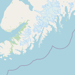
Map view of Kachemak Bay National Estuarine Research Reserve

Use this park location map to pinpoint Kachemak Bay National Estuarine Research Reserve in United States of America, understand its exact geographic position, and read its mapped placement within the surrounding landscape more clearly.

Pigeon | © OpenStreetMap contributors

Location context for Kachemak Bay National Estuarine Research Reserve

Alaska
Park atlas

Compare surrounding coastal landscapes, tidal ecosystems, and regional protected reserves

Parks Near Kachemak Bay National Estuarine Research Reserve and Regional Protected Areas

Continue geographic discovery by comparing Kachemak Bay National Estuarine Research Reserve with other protected areas across the surrounding coastal region. Examining adjacent terrain helps place marine reserves and upland forests within a broader regional context.
National parkAlaska
About 26 km away#1 closest

Northeast

Kenai Fjords National Park: Alaskan National Park & Protected Area Geographic Context

Mapped protected landscape and regional terrain discovery.

Kenai Fjords National Park serves as a key national park entity for understanding Alaska's protected lands. This destination focuses on the park's specific geographic identity and its role as a mapped protected landscape. Users can explore its protected area boundaries and gain insights into the regional geography it occupies, enriching an atlas-based view of natural terrains across Alaska.

Area
2,711.33 km²
Established
1980
IUCN
II
Visitors
425.4K annual
National parkAlaska
About 135 km away#2 closest

Southwest

Katmai National Park and Preserve: Alaska National Park Atlas and Protected Landscape Exploration

Discover mapped boundaries and regional geographic context within Alaska.

Katmai National Park and Preserve represents a significant protected landscape within the state of Alaska, offering a unique point for atlas-based geographic inquiry. This detail page provides structured information focused on the park's mapped boundaries, its place within regional geography, and the characteristics of its natural terrain. Understand the core identity of Katmai National Park and Preserve as a protected national park entity for comprehensive map exploration.

Area
16,564.1 km²
Established
1980
IUCN
II
Visitors
34.5K annual
National parkAlaska
About 189 km away#3 closest

Northwest

Lake Clark National Park and Preserve National Park: Alaska's Protected Landscape Discovery

Mapping the geographic context and protected park boundaries.

Lake Clark National Park and Preserve stands as a protected national park in Alaska, offering a distinct geographic identity for atlas exploration. Delve into its role as a protected landscape, examining its mapped presence within the Alaskan region. This resource provides structured insights into the park's protected area status and its contribution to the understanding of natural terrain and regional geography.

Area
16,308.9 km²
Established
1980
IUCN
V
Visitors
19.8K annual
National parkAlaska
About 394 km away#4 closest

Northeast

Wrangell, St. Elias National Park and Preserve: Alaska's Expansive National Park Geography

Mapped protected lands and regional landscape context.

Dive into the detailed geography of Wrangell, St. Elias National Park and Preserve, a prominent national park located in Alaska. This resource focuses on its extensive mapped boundaries and its role as a protected landscape, offering insights valuable for understanding regional geography and the distribution of natural areas.

Area
53,320.6 km²
Established
1980
IUCN
II
Visitors
79.5K annual
National parkAlaska
About 428 km away#5 closest

North

Denali National Park and Preserve: Detailed Protected Landscape and Map Exploration in Alaska

Explore its mapped boundaries and Alaskan regional geography.

Understand Denali National Park and Preserve as a distinct protected landscape within Alaska's vast geography. This park detail page offers insights into its mapped boundaries, natural terrain, and its contribution to the regional atlas of protected areas. Discover the geographic context that defines this significant national park, providing a foundation for detailed map-based exploration and understanding of its conservation significance.

Area
24,464 km²
Established
1917
IUCN
V
Visitors
427.6K annual
Wildlife reserveAlaska
About 536 km away#6 closest

Northwest

Innoko Wilderness: Geographic Profile and Protected Landscape of Interior Alaska

Subarctic wilderness tracking wetlands and boreal transitions

Spanning over one million acres in the Alaskan interior, Innoko Wilderness offers a unique look at a sprawling subarctic ecosystem. Dominated by muskeg, interconnected lakes, and the floodplains of the Yukon and Innoko Rivers, this protected area functions as a critical transition zone between interior forests and western tundra landscapes.

Area
5,000 km²
Established
1980
IUCN
Ib
Relief
Lowland
National parkYukon
About 582 km away#7 closest

East

Kluane National Park and Reserve: Yukon National Park Protected Area and Landscape Geography

Explore mapped boundaries and regional context for this Yukon national park.

Kluane National Park and Reserve represents a vital protected national park within Yukon. This detail page focuses on its geographic identity and mapped features, offering insight into its regional landscape context and its role within the broader Canadian protected areas atlas. Discover the park's specific topography and its location within Yukon.

Area
22,013 km²
Established
1972
IUCN
II
Visitors
47.1K annual
National parkAlaska
About 830 km away#8 closest

East

Glacier Bay National Park and Preserve: Alaska National Park Geographic Atlas

Mapped protected area context within Alaska's natural landscapes.

Glacier Bay National Park and Preserve serves as a vital protected landscape in Alaska, offering deep insights into regional geography and park boundaries. This detail page provides an atlas-centric view of the park, focusing on its role as a protected natural area and its unique position within the geographic tapestry of Alaska. Engage with structured data that illuminates the park's mapped terrain and its significance as a conservation landscape.

Area
13,045 km²
Established
1980
IUCN
V
Visitors
545.8K annual

Common questions about visiting, size, designation, and location context for Kachemak Bay National Estuarine Research Reserve

Kachemak Bay National Estuarine Research Reserve FAQs for park facts, access, geography, and protected area context

Find quick answers about Kachemak Bay National Estuarine Research Reserve, including protected-area facts, park geography, trail and visitor context, and how the park fits into its surrounding country and regional landscape.
MoriAtlas Explorer

Continue Your Protected Areas Search Across the Global Atlas

Deepen your exploration by continuing the structured search for national parks and protected areas worldwide. Utilize the comprehensive filtering capabilities to compare different conservation landscapes and refine your understanding of global park geography. Discover more about the distribution and characteristics of protected natural areas.

Global natural geography