

Mori Atlas logo
National parkKaeng Krung National Park

Understanding Kaeng Krung National Park's geographic boundaries and regional context.

Kaeng Krung National Park: National Park and Protected Landscape in Surat Thani Province

Kaeng Krung National Park stands as a protected natural area within Surat Thani Province, offering a unique glimpse into Thailand's diverse geography. As a designated national park, it represents a significant landmass dedicated to conservation, providing a crucial element for understanding regional landscape patterns. This entry is designed to illuminate the park's geographic identity and its place within the mapped protected areas of Southern Thailand.

national parkThailandPhuket mountain rangeforest protectionelephant habitatwatershed conservation

Kaeng Krung National Park

National park

Park overview

Structured park overview, official facts, and landscape profile for Kaeng Krung National Park

Kaeng Krung National Park park facts, protected area profile, and essential visitor context
Review the core facts for Kaeng Krung National Park, including designation, size, terrain, visitor scale, habitats, and operating context in one park-focused overview.

About Kaeng Krung National Park

Kaeng Krung National Park represents a significant protected area in Thailand's southern region, established in 1991 to preserve a substantial portion of the Phuket mountain range forest ecosystem. The park covers approximately 541 square kilometers, making it one of the larger national parks in the Surat Thani Province area. Its location in the northwest of the province places it within a mountainous landscape characterized by rugged terrain and dense vegetation typical of the Phuket mountain range.

The administrative boundaries of the park span four districts, creating a protected zone that encompasses diverse forest habitats across its mountain chains. The highest elevation within the park reaches 849 meters at Khao Sung, providing topographic diversity that supports varied ecological communities. Water drainage within the park follows two primary systems, with the northern portions feeding into the Lang Suan River via the Khlong Sa watercourse, while southern areas drain through the Khlong Yan to join the Phum Duang River.

The protected area serves multiple conservation functions, including habitat preservation for threatened species, watershed protection for downstream communities, and maintenance of forest cover in a region where agricultural expansion has reduced natural woodland. The park's establishment reflected Thailand's broader strategy of creating a representative protected area network covering different ecological zones across the country.

Quick facts and research context for Kaeng Krung National Park

Kaeng Krung National Park spans 541 square kilometers in northwest Surat Thani Province, southern Thailand. The protected area was officially designated on December 4, 1991, under the management of Thailand's Department of National Parks, Wildlife and Plant Conservation. The terrain features the Phuket mountain range with elevations reaching 849 meters at Khao Sung, the park's highest point. The park covers portions of four administrative districts and contains two major mountain chains with distinct drainage basins feeding into the Lang Suan and Phum Duang river systems.

Park context

Deeper park guide and search-rich context for Kaeng Krung National Park

Kaeng Krung National Park history, landscape, wildlife, and travel context
Explore Kaeng Krung National Park through its history, landscape character, ecosystems, wildlife, conservation priorities, cultural context, and seasonal travel timing in a structured park guide built for atlas discovery and search intent.

Why Kaeng Krung National Park stands out

Kaeng Krung National Park is best known for its extensive forest coverage within the Phuket mountain range, protecting one of the more significant remaining tracts of intact woodland in southern Thailand's Surat Thani region. The park preserves critical habitat for several notable mammal species including Asian elephants, gaurs, tapirs, and tigers, along with diverse primate populations and an array of bird species. Its mountain landscapes with peaks reaching nearly 850 meters offer forested scenery typical of the Phuket range, while the park's drainage systems connecting to major river basins underscore its role in watershed protection.

Kaeng Krung National Park history and protected-area timeline

Kaeng Krung National Park was officially declared a national park on December 4, 1991, becoming part of Thailand's expanding network of protected areas during the late twentieth century. The establishment of the park represented an acknowledgment of the ecological value of the remaining forest tracts in the Phuket mountain range of Surat Thani Province.

The decision to protect this area came amid growing recognition in Thailand of the need to preserve representative samples of the country's diverse ecosystems, particularly in peninsular Thailand where forest conversion had accelerated in preceding decades. The park was created under the national park framework administered by the Department of National Parks, Wildlife and Plant Conservation, which oversees the management of Thailand's protected areas.

Since its establishment, the park has continued to function as a protected forest area, though visitor numbers have remained modest, with approximately 909 visitors recorded in 2019, indicating that the park serves primarily a conservation function rather than heavy recreational use.

Kaeng Krung National Park landscape and geographic character

The landscape of Kaeng Krung National Park is defined by its position within the Phuket mountain range, a north-south trending mountain chain that forms a significant topographic feature of southern Thailand. The park encompasses two distinct mountain chains within its boundaries, creating varied terrain that ranges from lower slopes to elevations approaching 850 meters.

The highest peak, Khao Sung, rises to 849 meters and provides the most prominent topographic feature within the park. The mountainous terrain supports forest cover that grades from lower hill forest through montane vegetation at higher elevations. The park's valleys and slopes contain numerous streams and watercourses that drain the upland areas.

The drainage pattern of the park is divided between two major river systems. The northern portion of the park drains through the Khlong Sa watercourse, which flows toward the Lang Suan River system. The southern areas channel water through the Khlong Yan, eventually joining the Phum Duang River. This dual drainage system reflects the park's position along a drainage divide and contributes to its importance for watershed protection.

Kaeng Krung National Park ecosystems, habitats, and plant life

The forest ecosystems within Kaeng Krung National Park represent the vegetation types characteristic of the Phuket mountain range in peninsular Thailand. The park's elevation range and position within a mountainous area supports diverse forest communities that transition from lowland evergreen forest through hill evergreen forest to more open woodland at higher elevations.

The dense forest cover that characterizes much of the park provides critical habitat for numerous species and contributes to regional biodiversity in an area where forest loss has been significant. The watershed functions of the forested slopes are particularly important, with the park's drainage systems feeding into rivers that provide water resources for surrounding communities and agricultural areas.

The mountain chains within the park create environmental gradients that support varied plant communities, while the streams and riparian zones add additional habitat diversity to the overall ecosystem. The forest environment also plays a role in soil conservation and erosion control on the slopes, underscoring the ecological services provided by this protected area.

Kaeng Krung National Park wildlife and species highlights

Kaeng Krung National Park supports a diverse mammalian fauna reflecting the park's intact forest habitats within the Phuket mountain range. Notable species present in the park include Asian elephants, which represent a significant conservation presence in southern Thailand's remaining forested areas. The park also provides habitat for gaurs, the largest wild cattle species in the region, as well as tapirs and occasional tiger sightings.

Primates are well represented within the park, with several monkey species inhabiting the forest canopy and surrounding areas. The diverse primate community contributes to the park's ecological character and provides wildlife viewing opportunities for visitors who venture into the area.

Birdlife is particularly diverse, with numerous bird species recorded within the park boundaries. The combination of forest habitats, mountain terrain, and the availability of water sources in the streams and drainage channels creates conditions that support varied avian communities. The bird populations add significantly to the park's biodiversity value and make it an area of interest for ornithological observation.

Kaeng Krung National Park conservation status and protection priorities

Kaeng Krung National Park contributes to Thailand's conservation framework by protecting a substantial area of forest within the Phuket mountain range. The park's establishment in 1991 reflected the national strategy of preserving representative examples of different ecosystem types across Thailand's diverse environmental regions.

The protected area maintains significant populations of large mammals including elephants, gaurs, and tigers, species that require extensive habitat areas and are indicators of ecosystem health. The presence of these species within the park underscores its importance as a conservation area, particularly in the context of southern Thailand where forest fragmentation has reduced available habitat for wide-ranging species.

Beyond species protection, the park provides important watershed services through its forest cover, regulating water flow in the drainage basins that feed into the Lang Suan and Phum Duang river systems. This watershed function adds practical conservation value beyond biodiversity preservation, supporting downstream water resources for agricultural and community use.

Top sights and standout views in Kaeng Krung National Park

Kaeng Krung National Park protects extensive forested terrain in the Phuket mountain range of southern Thailand, with elevations reaching 849 meters at Khao Sung. The park supports populations of Asian elephants, gaurs, tapirs, and tigers within its boundaries, along with diverse primate communities and numerous bird species. Its dual drainage system feeding both the Lang Suan and Phum Duang rivers underscores its watershed significance. The park remains relatively undeveloped with modest visitor numbers, maintaining its primary conservation focus.

Best time to visit Kaeng Krung National Park

The optimal time to visit Kaeng Krung National Park falls within the dry season typical of southern Thailand, generally from November through April, when rainfall is reduced and trail conditions are more favorable for exploration. The cool season from November to February offers the most comfortable temperatures for hiking and outdoor activities within the park. The wet season from May through October brings increased rainfall to the region, which can affect trail accessibility and may limit some park activities. Visitors interested in wildlife observation may find the dry season particularly advantageous as animals tend to concentrate more visible near remaining water sources.
Park location guide

Geography guide, regional context, and park location map for Kaeng Krung National Park

Kaeng Krung National Park park geography, regions, and map view in Thailand
Understand where Kaeng Krung National Park sits in Thailand through a broader geographic reading of the surrounding landscape, nearby location context, and its mapped position within the national park landscape.

How Kaeng Krung National Park fits into Thailand

Thailand is a Southeast Asian nation formerly called Siam, located in mainland Southeast Asia. It operates as a unitary parliamentary constitutional monarchy under King Vajiralongkorn. The country borders Myanmar, Laos, Cambodia, and Malaysia, with maritime boundaries involving Vietnam, Indonesia, and India. Thailand has a population of nearly 66 million and covers approximately 513,120 km². Historically, the Sukhothai Kingdom marks the beginning of Thai history, followed by the powerful Ayutthaya Kingdom.

Wider geography shaping Kaeng Krung National Park in Thailand

Thailand occupies mainland Southeast Asia with borders to Myanmar (west/northwest), Laos (east/northeast), Cambodia (southeast), and Malaysia (south). The country has coastline along the Gulf of Thailand to the southeast and the Andaman Sea to the southwest. The territory covers approximately 513,120 km².

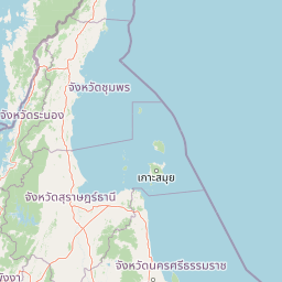
Map view of Kaeng Krung National Park

Use this park location map to pinpoint Kaeng Krung National Park in Thailand, understand its exact geographic position, and read its mapped placement within the surrounding landscape more clearly.

Pigeon | © OpenStreetMap contributors

Location context for Kaeng Krung National Park

Surat Thani Province
Park atlas

Trace the protected landscape geography and forest reserves across southern Thailand's Phuket Mountain Range.

Explore National Parks and Protected Areas Near Kaeng Krung National Park, Thailand
Browse national parks and protected areas near Kaeng Krung National Park, exploring the diverse forested terrain and mountain landscapes of southern Thailand. Compare key conservation areas and understand the regional network of protected zones, tracing how these park geographies connect across the wider region.
National parkSurat Thani Province

Khao Sok National Park: Protected Landscape Atlas and Geographic Detail

Explore mapped boundaries and regional terrain in Surat Thani Province.

Khao Sok National Park represents a crucial protected landscape within the expansive geography of Surat Thani Province, Thailand. This detailed entry focuses on the park's identity as a national park, emphasizing its mapped boundaries and the surrounding natural terrain. Through structured information and geographic context, users can gain a clear understanding of Khao Sok National Park's place in the atlas, contributing to a more informed approach to landscape discovery.

Area
739 km²
Established
1980
IUCN
II
Visitors
419.5K annual
National parkRanong

Laem Son National Park: A Protected National Park in Ranong's Geographic Landscape

Explore the mapped natural terrain and protected area boundaries.

Laem Son National Park is a key protected area within Thailand's Ranong province, offering valuable insights into regional geography and landscape preservation. This entry focuses on its status as a national park, providing a structured view of its protected boundaries and environmental context. Understand its unique position within the mapped geography, vital for any comprehensive atlas exploration of protected lands in the region.

Area
315 km²
Established
1983
IUCN
II
Visitors
21.9K annual
National parkPhang Nga Province

Khao Lak, Lam Ru National Park: Protected National Park Landscape and Geography

Explore its mapped boundaries and regional context in Phang Nga Province.

This entry focuses on Khao Lak, Lam Ru National Park, a designated national park offering a distinct protected landscape within Phang Nga Province, Thailand. It provides structured data and map context crucial for understanding its geographic scope and regional significance. Explore the park's mapped boundaries, its role as a protected area, and its contribution to the broader landscape of southern Thailand, fostering a deeper appreciation for its natural geography and atlas-derived insights.

Area
125 km²
Established
1991
IUCN
II
Visitors
72.2K annual
National parkSurat Thani Province

Mu Ko Ang Thong National Park: National Park with Distinct Protected Landscape and Geographic Context

Explore mapped boundaries within Surat Thani Province, Thailand.

Mu Ko Ang Thong National Park serves as a key protected area, offering a focused study of its specific geography and landscape features within the broader atlas of Surat Thani Province. As a national park, its mapped boundaries are crucial for understanding conservation landscapes in this part of southern Thailand. Users exploring this destination will find detailed context on its natural terrain and regional geographic placement.

Area
102 km²
Established
1980
IUCN
II
Visitors
134.3K annual
National parkNakhon Si Thammarat Province

Hat Khanom, Mu Ko Thale Tai National Park: National Park, Nakhon Si Thammarat Province, Thailand

Discover mapped boundaries and regional landscape context.

Hat Khanom, Mu Ko Thale Tai National Park is a designated national park offering a protected landscape within the geographic scope of Nakhon Si Thammarat Province. This entity provides a structured point for understanding its specific protected-area identity, its mapped terrain, and its contribution to the broader regional geography. Explore its geographic significance and atlas-relevant details to grasp its place in Thailand's natural landscape.

Area
312 km²
IUCN
II
Relief
Mixed relief
Climate
Tropical
National parkThailand

Ao Phang Nga National Park: A Protected National Park in Thailand's Geographic Atlas

Explore the mapped landscape and protected area identity.

Ao Phang Nga National Park offers a distinct protected landscape within Thailand, serving as a key entry in the national park atlas. This page focuses on delineating its geographic boundaries and understanding its specific characteristics as a national park. Users can discover the mapped context and regional setting, providing valuable insights into Thailand's protected natural areas and their conservation significance.

Area
400 km²
Established
1981
IUCN
II
Visitors
999K annual
National parkKrabi Province

Khao Phanom Bencha National Park: Protected Mountainous Rainforest and Waterfall Landscapes

Explore Krabi Province's unique protected area and its dramatic geographic features.

Khao Phanom Bencha National Park represents a core protected landscape within Krabi Province, Thailand. Dominated by the imposing Khao Phanom Bencha mountain range, its terrain includes steep, forested slopes and intricate valley systems that give rise to impressive waterfalls. This national park is an essential component of the region's protected natural areas, offering a detailed look at its unique ecosystem and geographic character through mapped landscape context and atlas exploration.

Area
50 km²
Established
1981
IUCN
II
Visitors
17.3K annual
National parkPhang Nga Province

Khao Lampi, Hat Thai Mueang National Park: Mountain Rainforest and Andaman Coast Atlas

Explore the mapped geography and protected boundaries.

Delve into Khao Lampi, Hat Thai Mueang National Park, a key protected area within Phang Nga Province, Thailand. This unique national park showcases a striking dichotomy: the lush, waterfall-adorned slopes of the Khao Lampi mountains contrast with the pristine Andaman Sea coastline of Hat Thai Mueang beach, a critical site for sea turtle nesting. The park's mapped landscape encompasses dense tropical rainforest, significant mangrove ecosystems, and important natural terrain, offering a comprehensive view of diverse protected environments for atlas exploration.

Area
72 km²
Established
1986
IUCN
II
Visitors
50.5K annual

Common questions about visiting, size, designation, and location context for Kaeng Krung National Park

Kaeng Krung National Park FAQs for park facts, access, geography, and protected area context
Find quick answers about Kaeng Krung National Park, including protected-area facts, park geography, trail and visitor context, and how the park fits into its surrounding country and regional landscape.
MoriAtlas Explorer

Continue Your Protected Areas Search Across the Global Atlas

Deepen your exploration by continuing the structured search for national parks and protected areas worldwide. Utilize the comprehensive filtering capabilities to compare different conservation landscapes and refine your understanding of global park geography. Discover more about the distribution and characteristics of protected natural areas.

Global natural geography