Mori Atlas logo
National parkKainji National Park

Understand the mapped geography and protected area context of this vital Nigerian natural landscape.

Kainji National Park: Nigeria's Premier Protected Landscape for Atlas Exploration

Kainji National Park stands as a key protected area within the diverse geography of Nigeria, offering a unique focus for atlas exploration. This national park provides a defined geographic scope, allowing users to trace its mapped boundaries and understand its place within the broader landscape of West Africa. Explore its natural terrain and gain structured insights into Nigeria's conservation efforts through detailed geographic context.

National ParkSavanna EcosystemWildlife ConservationWest African LionLake HabitatBirdwatching

Kainji National Park

National park

Park overview

Structured park overview, official facts, and landscape profile for Kainji National Park

Kainji National Park park facts, protected area profile, and essential visitor context
Review the core facts for Kainji National Park, including designation, size, terrain, visitor scale, habitats, and operating context in one park-focused overview.

About Kainji National Park

Kainji National Park represents Nigeria's premier effort to conserve the country's savanna ecosystems and the wildlife they support. The park's creation in 1978 formalized protection for a vast tract of Guinea savanna woodland interspersed with gallery forests along the Oli River and its tributaries. The central feature of the park is Kainji Lake, a 136-kilometer-long reservoir created by the Kainji Dam on the Niger River, which forms a critical aquatic habitat within the protected landscape. The Borgu Game Reserve to the west of the lake comprises the majority of the park's terrestrial area and remains the primary zone for tourism and wildlife management. The Zugurma Game Reserve to the southeast, while smaller, provides important dry-season refuges for wildlife around permanent waterholes. The park is managed by the Federal National Park Service with direct government funding, enabling enforcement actions under national park law rather than local courts. Recent developments include a 31-year co-management agreement signed in October 2023 with the West African Conservation Network to restore and strengthen protection amid ongoing security challenges that led to temporary suspension of operations in 2021.

Quick facts and research context for Kainji National Park

Kainji National Park covers 5,340.82 km² (2,062 sq mi) in northwestern Nigeria, straddling Niger State and Kwara State. The park was established in 1978 under IUCN Category II protection. It comprises three sectors: the Borgu Game Reserve (3,929 km²), the Zugurma Game Reserve (1,370 km²), and the Kainji Lake water body. The Borgu sector features undulating hills with quartzite ridges and ironstone pans, while the Zugurma sector consists of a low sandstone plateau. Annual rainfall averages about 1,100 mm with a wet season from May to November.

Park context

Deeper park guide and search-rich context for Kainji National Park

Kainji National Park history, landscape, wildlife, and travel context
Explore Kainji National Park through its history, landscape character, ecosystems, wildlife, conservation priorities, cultural context, and seasonal travel timing in a structured park guide built for atlas discovery and search intent.

Why Kainji National Park stands out

Kainji National Park is best known for its role as a protected savanna wilderness in northwestern Nigeria, centering on the massive Kainji Lake reservoir. The park is recognized as a Lion Conservation Unit, supporting populations of West African lions alongside other large mammals including elephants, leopards, cheetahs, and African wild dogs. Its three-sector structure combining aquatic, riparian, and upland savanna habitats makes it one of Nigeria's most ecologically diverse protected areas.

Kainji National Park history and protected-area timeline

Kainji National Park was formally established in 1978, consolidating the Borgu Game Reserve and Zugurma Game Reserve under unified national park management alongside the newly created Kainji Lake reservoir. The creation of the park followed the completion of the Kainji Dam in 1968, which flooded the valley and created the lake that now forms the park's aquatic core. Since 2005, the protected area has been recognized as a Lion Conservation Unit together with Yankari National Park, identifying it as a priority area for West African lion conservation. The park operates under the Federal National Park Service, receiving direct government funding and operating under national park law rather than local jurisdiction. Operations and research were temporarily suspended in 2021 due to insecurity in the region, alongside similar suspensions at Chad Basin and Kamuku National Parks. In October 2023, the Federal Government of Nigeria signed a 31-year co-management agreement with the West African Conservation Network, a Nigeria/United Kingdom-based conservation organization, to restore and enhance the park over the coming decade.

Kainji National Park landscape and geographic character

The landscape of Kainji National Park is characterized by two distinct topographies separated by the Kainji Lake reservoir. The Borgu sector features undulating hills with scattered quartzite ridges and ironstone pans, while the Zugurma sector consists of a low plateau with soils derived from sandstone that show significant erosion in places. The southern and western parts of the Borgu sector drain into the Oli River, a tributary of the Niger River, while other areas drain directly into the lake via four smaller rivers. The Zugurma sector has limited drainage, with smaller watercourses drying completely during the dry season, though several permanent waterholes persist along the Oli River and elsewhere in the park. The mean annual rainfall of approximately 1,100 mm supports a predominantly savanna landscape with varying density of woodland cover.

Kainji National Park ecosystems, habitats, and plant life

The nature of Kainji National Park reflects its position within the Guinean forest-savanna mosaic biome. The Borgu sector supports savanna woodland dominated by Burkea africana, Terminalia avicennioides, and Detarium microcarpum, with Isoberlinia tomentosa prevailing below quartzite ridges and Diospyros mespiliformis on drier lower slopes. Terminalia macroptera occurs in moist savanna areas, while Isoberlinia doka is found on higher ground in ironstone areas. The Zugurma sector, though overgrazed and eroded in places, supports typical Guinean forest-savanna mosaic vegetation including Afzelia africana, Pterocarpus erinaceus, Vitellaria paradoxa (the shea tree), and Khaya senegalensis, with tree cover densest along watercourses and permanent waterholes. Lake Kainji itself supports a diverse aquatic ecosystem with 82 recorded fish species.

Kainji National Park wildlife and species highlights

Kainji National Park supports remarkable biodiversity with 65 mammal species, 350 bird species, and 30 reptile and amphibian species documented within its boundaries. Large mammals include West African lions, leopards, caracals, elephants, and African manatees in the aquatic zones. Herds of various antelope species graze the savanna, while hippopotamuses occupy the lake and river channels. African wild dogs roam the woodland, and cheetahs hunt across the open plains. Smaller mammals include honey badgers, Senegal bushbabies, numerous monkey species, and African clawless otters. The reptile population features Nile crocodiles, West African slender-snouted crocodiles, four turtle species, Nile monitors, savannah monitors, and various snakes. The Zugurma sector supports less diverse wildlife due to poor drainage, overgrazing, and poaching pressures. Lake Kainji contains 82 fish species supporting both ecological and fisheries functions.

Kainji National Park conservation status and protection priorities

Kainji National Park serves as a critical conservation hub in West Africa, particularly as one of two designated Lion Conservation Units in Nigeria. The park's recognition alongside Yankari National Park since 2005 highlights its importance for maintaining viable populations of West African lions, a regionally distinct and endangered lion population. The protected status of Kainji Lake as a restricted fishing zone helps preserve aquatic biodiversity and fish populations. The 2023 co-management agreement with the West African Conservation Network represents a significant investment in the park's future, aiming to address security challenges and enhance conservation capacity over the next decade. However, the park faces ongoing pressures from poaching, overgrazing in the Zugurma sector, and regional insecurity that has temporarily disrupted management operations.

Kainji National Park cultural meaning and human context

Kainji National Park lies within a region of northwestern Nigeria inhabited by various communities whose traditional lands and livelihoods intersect with the protected area. The creation of Kainji Lake following the dam's construction in 1968 displaced communities and altered traditional fishing and agricultural practices along the Niger River floodplain. The Borgu and Zugurma reserves encompass areas used by local communities for seasonal grazing and resource collection, creating ongoing considerations for park management and community relations. The park's management under national law rather than local courts reflects the federal priority placed on conservation in this strategic region.

Top sights and standout views in Kainji National Park

Kainji National Park stands as Nigeria's largest protected area and a vital stronghold for West African savanna conservation. The park's three-sector structure offers diverse experiences from the open savanna woodlands of Borgu to the aquatic environments of Kainji Lake and the dry-season wildlife refuges of Zugurma. Its designation as a Lion Conservation Unit underscores regional conservation significance for endangered West African lion populations. The presence of elephants, leopards, cheetahs, and African wild dogs adds to the park's ecological importance, while 350 bird species and 82 fish species demonstrate remarkable biodiversity across terrestrial and aquatic habitats.

Best time to visit Kainji National Park

The optimal time to visit Kainji National Park corresponds with the dry season from December to April, when wildlife congregates around permanent water sources and vegetation is less dense, improving visibility for game viewing. The wet season from May to November brings lush green landscapes and migratory bird arrivals but can make some areas difficult to access, particularly in the Zugurma sector which has no access roads. Visitors interested in aquatic activities and fishing should note that fishing is restricted within the Kainji Lake sector of the park. The Borgu sector remains the primary tourism destination with existing access infrastructure.
Park location guide

Geography guide, regional context, and park location map for Kainji National Park

Kainji National Park park geography, regions, and map view in Nigeria
Understand where Kainji National Park sits in Nigeria through a broader geographic reading of the surrounding landscape, nearby location context, and its mapped position within the national park landscape.

How Kainji National Park fits into Nigeria

Nigeria is a West African federal republic spanning 923,769 km² between the Sahel and the Gulf of Guinea. It is Africa's most populous nation with over 236 million residents, composed of diverse ethnic groups including Hausa, Yoruba, Igbo, and numerous others. The country operates as a federal presidential republic with 36 states and the Federal Capital Territory, using English as its official language and possessing significant linguistic diversity with over 525 indigenous languages.

Wider geography shaping Kainji National Park in Nigeria

Nigeria occupies West Africa between the Sahel region to the north and the Gulf of Guinea in the Atlantic Ocean to the south. It shares borders with Niger to the north, Chad to the northeast, Cameroon to the east, and Benin to the west. The country covers an area of 923,769 square kilometres.

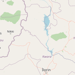
Map view of Kainji National Park

Use this park location map to pinpoint Kainji National Park in Nigeria, understand its exact geographic position, and read its mapped placement within the surrounding landscape more clearly.

Pigeon | © OpenStreetMap contributors

Location context for Kainji National Park

Kwara StateNiger State
Park atlas

Compare the surrounding savanna ecosystems and regional protected landscapes across Nigeria

Discover Other National Parks and Protected Areas Near Kainji National Park in Nigeria
After exploring Kainji National Park, browse other national parks and protected areas across Nigeria's diverse savanna wilderness and aquatic habitats to understand regional conservation efforts. Compare geographic features, wildlife conservation landscapes, and protected area characteristics to trace connected ecosystems and understand their distribution.
National parkNigeria

Kamuku National Park: Nigeria's Protected Savanna Ecosystem and Inselberg Landscape

Explore mapped boundaries and regional geography.

Delve into Kamuku National Park, a significant protected savanna ecosystem in Nigeria, recognized for its unique geological features such as the Goron Dutse inselberg and the Dogon Ruwa Waterfalls. This page offers an atlas-level view of the park's landscape, detailing its protected area status, its role as elephant habitat, and its exceptional biodiversity, providing a comprehensive geographic context for exploration.

Area
1,120 km²
Established
1999
IUCN
II
Relief
Lowland
National parkOyo State

Old Oyo National Park: Mapped Savanna Terrain and Historical Significance in Nigeria

Explore its geographic setting and protected landscape features.

Old Oyo National Park is a prominent national park situated in Nigeria's Oyo State, covering a substantial area of lowland savanna. The park's terrain features include scattered granite outcrops, ridges, and important archaeological sites, remnants of the ancient Oyo Empire. Its mapped geography reveals a dynamic landscape shaped by river systems and elevated formations, offering a unique blend of natural and cultural heritage for dedicated atlas exploration.

Area
2,512 km²
IUCN
II
Relief
Lowland
Climate
Tropical
National parkNiger

W National Park: Niger National Park, UNESCO World Heritage Site & Ramsar Wetland

Transborder savanna ecosystem and dramatic Niger River landscape.

W National Park in Niger offers a unique atlas view of a vast protected landscape defined by the Niger River's iconic W-shaped bend. As a UNESCO World Heritage Site and Ramsar Wetland, it protects crucial savanna plains, extensive floodplains, and rocky outcrops. This transborder conservation area is a vital habitat for West African wildlife, providing a rich context for geographic discovery and landscape exploration.

Area
10,000 km²
Established
1954
IUCN
II
Relief
Mixed relief
National parkBenin

Pendjari National Park: Exploring Benin's Largest Protected Area and Savanna Landscape

Mapped boundaries and regional geography of a key West African wilderness.

Pendjari National Park is the largest protected area in Benin, safeguarding nearly 2,800 square kilometers of essential West African savanna ecosystem. This national park is a crucial element of the WAP Complex, offering a profound look at one of the region's last viable wilderness expanses. Through its mapped terrain, diverse landscapes from river valleys to mountainous cliffs, and its status as a protected landscape, users gain a deep understanding of its geographic significance and conservation value.

Area
2,755 km²
IUCN
II
Relief
Highland
Climate
Subtropical
National parkTapoa Province

Arli National Park National Park: Mapped Protected Landscape in Tapoa Province

Explore its geographic context and boundaries.

Arli National Park stands as a critical protected area, identified as a national park within Tapoa Province. This detail page serves as an atlas-focused entry point to understanding the park's unique landscape characteristics and its precise geographic location. Users can investigate its mapped boundaries and explore how it fits into the regional geography, offering a foundational understanding for protected-area discovery.

Area
760 km²
Established
1954
IUCN
IV
Relief
Upland
National parkKara Region

Oti-Kéran National Park: Togo's Vast Protected Savanna Ecosystem and Regional Geography

Explore the mapped terrain and protected landscape of this key national park.

Delve into the geography of Oti-Kéran National Park, Togo's largest national park situated in the Kara Region. This protected savanna landscape, recognized as a Ramsar site, offers insights into its unique sudanian zone terrain, important bird habitats, and its function as a wildlife migration corridor. Understanding its mapped boundaries and ecological significance provides a core piece of the West African protected areas atlas.

Area
690 km²
Established
1950
IUCN
II
Relief
Lowland
National parkEdo State

Okomu National Park: Protected Landscape and National Park Geography in Edo State

Explore mapped terrain and protected area boundaries.

Okomu National Park represents a significant protected area within Nigeria, situated in Edo State. This dedicated page offers a focused view of its geography and landscape, aiding in atlas-driven discovery of its mapped terrain and conservation boundaries. Understand the park's role within the regional geographic framework and explore its unique natural landscape context.

Area
200 km²
Established
1935
IUCN
II
Relief
Lowland
National parkOti Region

Kyabobo National Park: Ghana's Highland National Park with Mount Dzebobo and Forest-Savanna Transition

Explore mountainous terrain, park boundaries, and regional geography in Oti Region.

Kyabobo National Park is a significant protected landscape in Ghana's Oti Region, celebrated for its mountainous topography and the commanding presence of Mount Dzebobo. This national park, established in 1993, safeguards a critical ecological transition zone featuring diverse habitats from dense forests to open tree savanna. Its unique geography and protected status make it a vital site for understanding regional conservation and atlas-based landscape exploration in West Africa, offering insights into varied terrain and ecosystems.

Area
360 km²
Established
1993
IUCN
II
Relief
Mountain

Common questions about visiting, size, designation, and location context for Kainji National Park

Kainji National Park FAQs for park facts, access, geography, and protected area context
Find quick answers about Kainji National Park, including protected-area facts, park geography, trail and visitor context, and how the park fits into its surrounding country and regional landscape.
MoriAtlas Explorer

Continue Your Protected Areas Search Across the Global Atlas

Deepen your exploration by continuing the structured search for national parks and protected areas worldwide. Utilize the comprehensive filtering capabilities to compare different conservation landscapes and refine your understanding of global park geography. Discover more about the distribution and characteristics of protected natural areas.

Global natural geography