

Mori Atlas logo
National parkKenting National Park

Discover the mapped protected areas and regional geography of Kenting National Park.

Kenting National Park: Taiwan's Southernmost National Park Landscape and Geographic Atlas

Kenting National Park stands as a significant protected landscape in Pingtung County, Taiwan, offering rich opportunities for geographic discovery and atlas exploration. This page serves as the authoritative entry point for understanding the park's mapped boundaries, its unique position within Taiwan's national park network, and its contribution to regional natural landscape context. Delve into the structured geography and protected-area identity of Kenting National Park to enhance your understanding of this vital conservation area.

tropical national parkcoral reefscoastal landscapesTaiwanmarine conservationbird migration

Kenting National Park

National park

Park overview

Structured park overview, official facts, and landscape profile for Kenting National Park

Kenting National Park park facts, protected area profile, and essential visitor context
Review the core facts for Kenting National Park, including designation, size, terrain, visitor scale, habitats, and operating context in one park-focused overview.

About Kenting National Park

Kenting National Park occupies the Hengchun Peninsula at the southern tip of Taiwan's main island, representing a unique convergence of tropical marine and terrestrial ecosystems. The park's establishment in 1984 marked a significant milestone in Taiwan's conservation history, making it the nation's oldest national park and the first to protect such a diverse range of subtropical habitats. The protected area extends from the mountainous northern regions through the central Hengchun Longitudinal Valley Plain to the southern coral tablelands that meet the sea. The park's coastal waters include Nan Wan (South Bay) and Banana Bay, where coral reef ecosystems thrive in the confluence of the Pacific Ocean, Taiwan Strait, and Luzon Strait.

The park's cultural significance extends beyond its natural wonders. The name Kenting derives from Taiwanese Hokkien meaning pathfinders or pioneers, reflecting the region's historical role as a frontier area. The landscape is marked by geological diversity, with the east side of the coral tablelands featuring unique sand rivers and sand waterfalls formed by the combined effects of winds and rivers, as well as coral cliffs, sunken caves, and stalactite formations. Longluan Lake, a vast lake formed within the fault valleys of the plain, provides additional ecological diversity to the park's already complex landscape.

Quick facts and research context for Kenting National Park

Kenting National Park occupies the Hengchun Peninsula in southern Taiwan, spanning Hengchun, Checheng, and Manzhou Townships. The park encompasses about 181 square kilometers of land and 152 square kilometers of marine territory. It is located approximately 90 kilometers from Kaohsiung and 140 kilometers from Tainan. The park features a landscape divided by the Hengchun Longitudinal Valley Plain, with coral sea cliffs and fringing reefs along the western coast, mountainous terrain in the north, and coral tablelands with limestone caves in the south. The region experiences a tropical monsoon climate with warm to hot weather year-round and an average annual precipitation of nearly 2,000 millimeters.

Park context

Deeper park guide and search-rich context for Kenting National Park

Kenting National Park history, landscape, wildlife, and travel context
Explore Kenting National Park through its history, landscape character, ecosystems, wildlife, conservation priorities, cultural context, and seasonal travel timing in a structured park guide built for atlas discovery and search intent.

Why Kenting National Park stands out

Kenting is best known for its dramatic tropical coastal scenery, featuring coral sea cliffs with fringing reefs, unique coral tablelands with sandstone rivers and waterfalls, and pristine beaches that attract surfers and sun-seekers alike. The park is famous for housing Eluanbi Lighthouse, a fortified lighthouse completed in 1883 that stands as one of the world's rare examples of a lighthouse with integrated defensive fortifications. The annual Spring Scream rock-band festival held every March has become a cultural institution drawing international visitors. The park's biodiversity is equally notable, supporting the world's highest diversity of terrestrial crabs in a single area, significant populations of reintroduced Formosan sika deer, and critical marine habitat for endangered sea turtles and migratory whales.

Kenting National Park history and protected-area timeline

Kenting National Park was officially established on 1 January 1984, becoming Taiwan's inaugural national park and establishing a model for protected area management in the country. The creation of the park reflected growing recognition of the need to preserve Taiwan's unique coastal and subtropical ecosystems, which had faced increasing development pressure during the post-war period. The park's administration falls under the National Park Service of the Ministry of the Interior, with the Kenting National Park Headquarters managing daily operations.

The region's history extends far beyond the modern park establishment. The Eluanbi Lighthouse, located at Cape Eluanbi, was completed in 1883 following requests from the American and Japanese governments to the Chinese government after several shipwrecks occurred in the 1860s, including the Rover incident. Construction required protection from Chinese troops due to attacks by local tribesmen, and the lighthouse was surrounded by a fort with cannons and a ditch, making it one of the rare fortified lighthouses in the world. The lighthouse stands 21.4 meters high with its light positioned 56.4 meters above high water, flashing every 10 seconds with a range of 27.2 nautical miles.

The area has also appeared prominently in popular culture, with most parts of the 2008 film Cape No. 7 filmed within the park and nearby Hengchun, and portions of the 2012 film Life of Pi shot in the park's diverse landscapes.

Kenting National Park landscape and geographic character

The landscape of Kenting National Park is characterized by remarkable diversity shaped by geological processes and marine influences. The park is fundamentally divided into two main terrain types by the long and narrow Hengchun Longitudinal Valley Plain, which extends from north to south through the center of the peninsula. The northern region features a large number of mountains rising from the coastal plain, while the southern portion is dominated by coral tablelands and foothills.

The western coast presents dramatic coral sea cliffs teamed with fringing reefs, where wave action has carved intricate patterns into the limestone formations. Coral tablelands dominate the eastern and southern reaches, characterized by their distinctive formations including unique sand rivers and sand waterfalls that result from the combined effects of wind and water erosion. The eastern side of these tablelands also features coral cliffs, sunken caves, and stalactite-filled limestone caves that add to the park's geological complexity.

The Hengchun Longitudinal Valley Plain, formed by fault valleys, contains Longluan Lake, a significant inland water body that provides habitat for wetland species and adds to the landscape diversity. The marine portion of the park encompasses Nan Wan (South Bay) and Banana Bay, surrounded by the Pacific Ocean, Taiwan Strait, and Luzon Strait, creating a complex coastal ecosystem where tropical marine life thrives.

Kenting National Park ecosystems, habitats, and plant life

Kenting National Park supports exceptionally rich terrestrial and marine biodiversity within its relatively compact area. The park hosts 15 species of mammals, 310 species of birds, 59 species of reptiles and amphibians, 21 species of freshwater fish, 216 species of butterflies, and numerous other insects. The Longkeng Ecological Protection Area preserves coral reefs and virgin forest within Banana Bay and along the Hengchun Peninsula, serving as a critical conservation zone within the park.

The marine environment around the park is influenced by ocean currents that bring rich nutrients and support diverse marine ecosystems. The waters are home to sea birds, critically endangered hawksbill turtles, bull sharks, manta rays, whale sharks, and various cetaceans. Historically, the area served as a major wintering ground for sperm whales and baleen whales, particularly humpback whales that migrated into Nan Wan and Banana Bay. Japanese whaling during the colonial period led to severe depletions of these whale populations, and today they are rarely observed in the region.

The park serves as an important stopover on the migration path of the gray-faced buzzard, linking the park to broader East Asian flyway conservation networks.

Kenting National Park wildlife and species highlights

Kenting National Park supports remarkable wildlife diversity, with particular significance in its terrestrial crab populations, which represent the highest diversity of land crabs found in any single area worldwide, with 26 species recorded. The park is home to 34 species of terrestrial mammals, including five that are locally extinct such as the Formosan clouded leopard and four that have been introduced, including water buffalo.

The Formosan sika deer holds special conservation significance within the park. This species became extinct in the wild in 1969 but was first reintroduced into Kenting National Park in 1994, representing one of the success stories of captive breeding and reintroduction in Taiwan. Additionally, the critically endangered Chinese pangolin, thought to have been extinct from the area, was rediscovered in the park a decade after it was considered locally extinct.

Marine wildlife includes critically endangered hawksbill turtles that nest on the park's beaches, along with bull sharks, manta rays, and whale sharks in the deeper waters. The park's position at the convergence of major water bodies creates important habitat for migratory species, though whale populations have been dramatically reduced from their historical abundance.

Kenting National Park conservation status and protection priorities

Kenting National Park represents a critical conservation priority in Taiwan due to its unique combination of tropical coastal ecosystems, significant biodiversity, and the pressure from high visitor numbers. The establishment of the Longkeng Ecological Protection Area demonstrates the park's commitment to preserving the most sensitive habitats, including coral reefs and old-growth forests in Banana Bay and along the Hengchun Peninsula.

The marine conservation dimension is particularly important given the park's location at the intersection of three major water bodies. Coral reef communities face threats from both natural and anthropogenic factors, and the park provides protected status for these ecosystems. The reintroduction program for Formosan sika deer represents a significant conservation achievement, demonstrating the potential for recovering species from extinction in the wild through carefully managed reintroduction efforts.

The park's role as a migratory bird pathway adds regional conservation significance, connecting Taiwan's conservation network with broader East Asian flyway protections. However, the high visitor numbers, with nearly 6 million annual visitors, present ongoing challenges for balancing conservation with public access.

Kenting National Park cultural meaning and human context

The cultural landscape of Kenting reflects the region's position as a historical frontier between Chinese settlement and indigenous territories. The name Kenting itself, derived from Taiwanese Hokkien meaning pathfinders or pioneers, directly references this frontier heritage and the role of early settlers in opening the southern peninsula. The construction of Eluanbi Lighthouse in 1883 required negotiation between multiple colonial powers and local communities, illustrating the complex historical interactions that shaped the region.

The park area includes traditional townships of Hengchun, Checheng, and Manzhou, where local communities maintain connections to the landscape that predate the national park designation. The annual Spring Scream festival, held since 1995, has become an integral part of the park's cultural identity, transforming Kenting into a venue for youth culture and musical expression that coexists with the natural environment.

The proximity to director Ang Lee's birthplace adds a connection to Taiwan's contemporary cultural production, while the filming of Cape No. 7 and Life of Pi within the park boundaries demonstrates how the landscape has served as a backdrop for stories that resonate with Taiwanese identity.

Top sights and standout views in Kenting National Park

Kenting National Park stands out for its remarkable concentration of natural and cultural attractions within a compact tropical coastal setting. The Eluanbi Lighthouse, with its unique fortified design and 140-year history, represents a singular historical landmark that combines navigational importance with defensive architecture rarely seen globally. The coral sea cliffs and fringing reefs along the western coast provide accessible marine environments for snorkeling and diving, while the beaches of Nan Wan and Banana Bay serve both relaxation and surfing communities.

The park's biodiversity significance extends beyond individual species to ecosystem-level diversity, with the world's highest recorded terrestrial crab diversity in a single area, significant coral reef communities, and important migratory bird pathways. The successful reintroduction of Formosan sika deer demonstrates tangible conservation outcomes, while the landscape's geological diversity, including coral tablelands, limestone caves, and sandstone formations, provides scientific and educational value alongside scenic appeal.

Best time to visit Kenting National Park

Kenting National Park can be visited year-round due to its tropical climate, with warm to hot weather persisting throughout the year. The park experiences its peak visitor season during the summer months when temperatures reach their highest, typically ranging from the high 20s to low 30s Celsius, and school vacations draw families to the beaches. The annual Spring Scream festival in March transforms the park into a vibrant cultural venue, attracting music enthusiasts and creating a different atmosphere than the typical beach-focused visitation.

The monsoon season brings higher rainfall from May through October, with August typically recording the highest precipitation, yet these remain warm rains that rarely disrupt outdoor activities completely. The winter months from December through February offer slightly cooler temperatures, making daytime exploration more comfortable for hiking and sightseeing, though the park remains a viable destination throughout the year. The combination of year-round accessibility and diverse attractions ensures that any visit can offer rewarding experiences, though those seeking to avoid peak crowds might consider the shoulder seasons between major holiday periods.
Park location guide

Geography guide, regional context, and park location map for Kenting National Park

Kenting National Park park geography, regions, and map view in Taiwan
Understand where Kenting National Park sits in Taiwan through a broader geographic reading of the surrounding landscape, nearby location context, and its mapped position within the national park landscape.

How Kenting National Park fits into Taiwan

Taiwan is an island nation in East Asia situated between the East China Sea and South China Sea. With a population of approximately 23.3 million people, it is one of the most densely populated countries in the world. The island features mountain ranges dominating its eastern region and densely populated plains in the west, where major cities including Taipei and New Taipei City are located.

Wider geography shaping Kenting National Park in Taiwan

Taiwan is located in the western Pacific Ocean, bordered by the East China Sea to the northwest and the South China Sea to the southwest. The People's Republic of China lies to the northwest across the Taiwan Strait, Japan is to the northeast, and the Philippines are to the south. The main island features mountain ranges dominating the eastern two-thirds of the territory, with plains concentrated in the western third where the majority of the population resides.

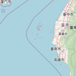
Map view of Kenting National Park

Use this park location map to pinpoint Kenting National Park in Taiwan, understand its exact geographic position, and read its mapped placement within the surrounding landscape more clearly.

Pigeon | © OpenStreetMap contributors

Location context for Kenting National Park

Pingtung County
Park atlas

Map Taiwan's diverse protected landscapes, comparing coastal parks, coral reefs, and mountainous terrain within regional context.

Explore Nearby National Parks and Protected Areas Beyond Kenting National Park's Coastal Landscapes
After exploring Kenting's unique tropical coastal and marine ecosystems, discover other national parks and protected areas across Taiwan. Compare their diverse geography, conservation priorities, and landscapes, from coral tablelands to inland mountains, for comprehensive regional park understanding.
National parkTainan

Taijiang National Park: National Park Atlas and Protected Landscape Exploration

Discover mapped boundaries and regional geography.

Taijiang National Park offers a distinct look into protected natural landscapes within Tainan, Taiwan. This page details its identity as a national park, focusing on its mapped geographic features and its contribution to the regional atlas. Users can explore the specific protected area context and understand the landscape characteristics relevant to a structured geographic discovery approach.

Area
393.1 km²
Established
2009
IUCN
II
Relief
Lowland
National parkNantou County

Yushan National Park: Explore Taiwan's Highest Mountain and Alpine Protected Terrain

Mapped geography and dramatic peaks within Nantou County.

Yushan National Park is a crucial protected area in Taiwan, renowned for encompassing the island's highest mountain and a significant portion of the Central Mountain Range. This national park's dramatic geography spans over 103,000 hectares, with two-thirds of its territory lying above 2,000 meters. Its vertical ecological zones, from subtropical forests to alpine environments, offer a rich tapestry of landscapes ideal for atlas-style exploration of protected terrain and mountain peak geography.

Area
1,031.21 km²
Established
1985
IUCN
II
Visitors
1M annual
National parkTaiwan

South Penghu Marine National Park: A Protected Volcanic Island Landscape in Taiwan's Penghu Archipelago

Mapped marine protected areas and unique geological features.

Discover the unique atlas value of South Penghu Marine National Park, Taiwan's protected national park renowned for its dramatic columnar basalt landforms and extensive coral reef systems. This marine protected area provides critical habitat for diverse species and showcases a rugged island geography shaped by volcanic activity. Explore its mapped boundaries and unique geological formations, including famous sea caves, offering a distinct context for landscape discovery.

Area
358.44 km²
Established
2014
IUCN
II
Visitors
8.4K annual
National parkHualien County

Taroko National Park: Detailed National Park Geography and Protected Landscape Context

Explore mapped boundaries and natural terrain in Hualien County.

Taroko National Park represents a significant protected landscape within Taiwan, offering rich opportunities for geographical exploration and understanding protected-area distribution. As a designated national park, its mapped boundaries and unique terrain provide essential context for appreciating the natural geography of Hualien County and the surrounding region. This page supports detailed discovery of Taroko National Park's identity as a distinct protected area, ideal for atlas-based research and landscape comprehension.

Area
920 km²
Established
1986
IUCN
II
Relief
Mountain
National parkMiaoli County

Shei-Pa National Park: Explore Taiwan's National Park Protected Landscape in Miaoli County

Mapped geographic boundaries and regional park context.

Shei-Pa National Park is a vital protected area in Miaoli County, Taiwan, offering rich opportunities for geographic and atlas-based exploration. Delve into the specifics of its mapped park boundaries and understand its role within the broader regional landscape. This destination provides essential context for discovering Taiwan's protected natural areas and their unique geographic characteristics.

Area
768.5 km²
Established
1992
IUCN
II
Relief
Mountain
National parkTaiwan

Yangmingshan National Park: Volcanic Terrain and Geothermal Features Atlas

Explore Taiwan's protected national park geography and mapped landscapes.

Yangmingshan National Park presents a striking example of volcanic geography, characterized by its rugged mountain terrain, active craters like Xiaoyoukeng, and ubiquitous geothermal features such as hot springs and sulfur deposits. As a protected national park within Taiwan, its landscape offers a rich context for understanding volcanic processes and alpine ecosystems. MoriAtlas provides detailed map exploration of Yangmingshan National Park, highlighting its unique geological formations and protected boundaries for an in-depth geographic discovery experience.

Area
113 km²
Established
1985
IUCN
II
National parkKinmen County

Kinmen National Park: National Park Protected Landscape and Geographic Context

Mapped boundaries and regional park geography for atlas exploration.

Kinmen National Park stands as a significant protected area within Kinmen County, Taiwan. This page focuses on its identity as a national park, detailing its mapped boundaries and contributing to an understanding of its regional geographic context. It is designed for users seeking to explore the park's protected landscape features and its position within the broader atlas of natural areas.

Area
35.29 km²
Established
1995
IUCN
II
Relief
Upland
National parkOkinawa Prefecture

Iriomote-Ishigaki National Park: Subtropical Island Geography and Protected Landscape Atlas

Explore the unique terrain and mapped boundaries of this national park.

Dive into the geography of Iriomote-Ishigaki National Park, a protected national park situated in Japan's Okinawa Prefecture. This page provides a detailed atlas view of its characteristic subtropical island terrain, including extensive mangrove forests, distinct limestone karst features, and surrounding marine protected areas. Understand the park's unique landscape and its significance within the broader regional geography for comprehensive exploration.

Area
1,221.5 km²
Established
1972
IUCN
II
Climate
Subtropical

Common questions about visiting, size, designation, and location context for Kenting National Park

Kenting National Park FAQs for park facts, access, geography, and protected area context
Find quick answers about Kenting National Park, including protected-area facts, park geography, trail and visitor context, and how the park fits into its surrounding country and regional landscape.
MoriAtlas Explorer

Continue Your Protected Areas Search Across the Global Atlas

Deepen your exploration by continuing the structured search for national parks and protected areas worldwide. Utilize the comprehensive filtering capabilities to compare different conservation landscapes and refine your understanding of global park geography. Discover more about the distribution and characteristics of protected natural areas.

Global natural geography