
Lakes
Park geography
Analyzing the arid landscape, administrative reach, and terrain of the transboundary region
Detailed Geographic Profile and Mapped Boundaries of Kgalagadi Transfrontier Park
The Kgalagadi Transfrontier Park spans 38,000 square kilometers across South Africa and Botswana, encompassing desert terrain and riverbeds. This structured geography profile maps the regional distribution, boundary extents, and physical viewpoints across this arid protected landscape.
Related tags
Transfrontier ParkKalahari DesertPeace ParkBig Five TerritoryLion Conservation Unit
Vast Kalahari wilderness spanning Botswana and South Africa
Kgalagadi Transfrontier Park
Kgalagadi Transfrontier Park is one of the largest transfrontier conservation areas in southern Africa, spanning the border between Botswana and South Africa. The park encompasses two adjoining national parks: Kalahari Gemsbok National Park in South Africa and Gemsbok National Park in Botswana. With a total area of approximately 38,000 square kilometers, the protected area occupies much of the southern Kalahari Desert, a region where the name Kgalagadi, meaning 'place of thirst,' accurately describes the harsh yet beautiful desert environment. The landscape is characterized by sweeping red sand dunes, sparse vegetation, and the dramatic dry riverbeds of the Nossob and Auob Rivers, which flow underground and only surface briefly after rare thunderstorms. This vast wilderness supports remarkable biodiversity, with over 470 documented wildlife species including large predators such as lion, cheetah, and leopard, as well as migratory herds of gemsbok, springbok, and blue wildebeest. Established as Africa's first peace park in 2000, Kgalagadi represents a pioneering model of cross-border conservation cooperation.
- Location
- Botswana
- Park type
- National park
- Established
- 2000
- Area
- 38,000 km²
Location overview
A shared conservation landscape spanning Botswana and South Africa
Kgalagadi Transfrontier Park Geographic Profile and Location
The park territory encompasses parts of the Northern Cape and Kgalagadi District within South Africa and Botswana. As a mapped transboundary area, its interior landward geography contains no coastal or marine sectors.
- Countries
- Botswana, South Africa
- Regions
- Kgalagadi District, Northern Cape
- Primary location
- Kgalagadi District
- Geographic setting
- Transboundary · Inland
Boundary and coordinates
Interactive boundary geometry and calculated spatial measurements
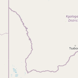
Kgalagadi Transfrontier Park Boundary Map and Spatial Extent
Mapped park outlines provide clear spatial context for analyzing protected area boundaries. Accompanying facts detail total area coverage and coordinate spans without survey precision.
- Boundary area
- 35,544.7 km²
- Boundary perimeter
- 805.3 km
- Northernmost point
- 24.0971° S
- Southernmost point
- 26.4768° S
- Easternmost point
- 22.1575° E
- Westernmost point
- 19.9984° E
- Geographic centre
- 25.3038° S, 20.8485° E
- North–south span
- 263.6 km
- East–west span
- 217.5 km
Terrain and natural features
Lowland classification and mapped waterholes, pans, and viewpoints
Kgalagadi Transfrontier Park Terrain and Recorded Natural Features
Kgalagadi Transfrontier Park features lowland terrain classifications alongside recorded waterholes, pans, and viewpoints situated within the protected area. Linked feature cards supply specific names, types, and spatial relationships for each mapped natural feature.
Selected named natural features
Viewpoints
Nossob River Viewpoint
Reservoirs
Geinab Waterhole
Lakes
Malatso Pan
Viewpoints
Kransbrak
Lakes
Gnus Gnus Pan
Environmental setting
Arid desert terrain, lowland relief, and ancient riverbeds across the landscape
Kgalagadi Transfrontier Park Environmental Classifications and Physical Settings
Recorded environmental classifications group dune systems, arid desert habitats, and lowland relief into complementary categories for physical setting analysis. Connected atlas pathways link these recorded attributes to broader geographic destinations and regional context.
- Relief
- Lowland
- Climate
- Arid
- Water
- Minor water
- Forest cover
- No forest cover
- Seasonality
- Year-round
Landscape features
Dunes · Rivers
Habitat types
Desert habitat
Park atlas
Trace the vast protected landscapes surrounding Kgalagadi Transfrontier Park, mapping cross-border conservation areas.
Explore Nearby National Parks and Protected Areas Beyond Kgalagadi Transfrontier Park
Explore additional national parks and protected areas that share geographic context or protected-landscape characteristics with Kgalagadi Transfrontier Park. Compare their unique desert ecosystems, predator populations, and conservation strategies to deepen your atlas-based understanding of the region's wilderness.
National parkNorthern Cape
216 km away#1 closest
South

Augrabies Falls National Park: A South African National Park Defined by Granite Gorge and Semi-Desert Terrain
Explore the mapped natural landscape and protected boundaries.
Augrabies Falls National Park in South Africa's Northern Cape Province is a key protected area known for its thundering waterfall on the Orange River and the profound granite gorge carved over millennia. The park's semi-desert environment showcases the distinctive quiver trees and geological landmarks like Moon Rock, offering a unique landscape context. Understand its protected status and geographic significance within the arid Nama-Karoo biome through detailed mapping and landscape information.
- Area
- 820 km²
- Established
- 1966
- IUCN
- II
- Relief
- Upland
Nature reserveNorthern Cape
About 278 km away#2 closest
Southeast
Witsand Nature Reserve: Protected Sand Dunes and Northern Cape Regional Geography
A remote arid plateau and singing sand landscape
Witsand Nature Reserve encompasses a 3,500 hectare protected area set atop a rocky plateau in the Northern Cape. Known for its distinctive red Kalahari-style dunes that produce acoustic booming sounds, the reserve offers a unique look at the arid interior of South Africa through a lens of quiet, expansive geography and remote terrain.
- Area
- 31.7 km²
- Established
- 1994
- Relief
- Upland
- Climate
- Arid
Nature reserveWindhoek
About 342 km away#3 closest
Northwest

Südwest-Naturreservat: A Protected Botanical Nature Reserve in Central Windhoek
Conservation landscapes and native flora in the Khomas Highland
Located in central Windhoek, Südwest-Naturreservat functions as a key protected area and botanical site. It showcases a diverse collection of Namibian plants across both landscaped and natural terrain, offering a focused look at arid and semi-arid flora within an accessible urban environment that highlights the region's unique biodiversity.
- Area
- 0.12 km²
- Established
- 1970
- IUCN
- V
- Relief
- Upland
Nature reserveNamibia
About 351 km away#4 closest
West
Tirasberge Nature Reserve: Geography and Protected Landscapes of Southern Namibia
A compact wilderness spanning mountain massifs and desert frontiers.
The Tirasberge region serves as a vital protected area in southern Namibia, showcasing a diverse intersection of mountain ridges, red sand dunes, and arid savanna plains. This reserve provides a unique look into a stratified landscape where high elevation terrain meets the lower reaches of the Namib dune sea, creating a complex corridor for ecology and history. Understanding the reserve reveals how mountain-to-savanna transitions define the rugged character of this southern African conservation zone.
- Area
- 1,250 km²
- Established
- 1998
- Relief
- Mountain
- Climate
- Arid
National parkNamibia
361 km away#5 closest
West
Namib-Naukluft National Park: Namibia's Iconic Desert Landscape and Protected Terrain
Explore its ancient dunes, Naukluft mountains, and coastal geography.
Namib-Naukluft National Park is a colossal protected area in Namibia, holding the distinction of being Africa's largest national park. This park is renowned for its iconic sand dunes, particularly at Sossusvlei, which are among the highest in the world and display dramatic colors due to iron oxidation. The landscape also features the rugged Naukluft Mountains and vital coastal fog zones, creating a diverse arid environment. Delve into the mapped geography and unique terrain of this ancient desert setting, understanding its protected landscape significance within Namibia's atlas.
- Area
- 49,768 km²
- Established
- 1907
- IUCN
- II
- Relief
- Mixed relief
National parkNorthern Cape
363 km away#6 closest
Southwest
Richtersveld National Park: Geographic and Protected Area Map Context
Exploring arid volcanic landscapes in Northern Cape
Richtersveld National Park represents a vast, complex protected area defined by its rugged mountain ridges and arid desert ecology. Centered in South Africa's Northern Cape, the landscape is shaped by the Orange River and high-altitude volcanic formations. This profile offers detailed insight into the park's natural boundaries, endemic plant habitats, and its role as a living cultural landscape within the wider regional geography.
- Area
- 1,624.45 km²
- Established
- 1991
- Relief
- Mountain
- Climate
- Arid
Wildlife reserveNamibia
About 374 km away#7 closest
Southwest
ǀAi-ǀAis Hot Springs Game Park: A Namibian Wildlife Reserve Bridging Desert and Geothermal Landscapes
Explore mapped boundaries and regional park geography.
ǀAi-ǀAis Hot Springs Game Park represents a vital protected area within Namibia's arid southern reaches. This wildlife reserve is characterized by its namesake hot springs, which foster unique riparian ecosystems against a backdrop of rugged desert mountains and the impressive Fish River canyon. Its inclusion in a transfrontier conservation effort underscores its significance for regional landscape mapping and the preservation of stark desert beauty and geothermal features.
- IUCN
- II
- Relief
- Mixed relief
- Climate
- Arid
- Access
- Remote access
Protected areaNamibia
About 374 km away#8 closest
Southwest
Ai-Ais/Richtersveld Transfrontier Park: Mapped Boundaries of a Southern African Protected Area
Exploring its desert terrain and cross-border conservation geography.
Ai-Ais/Richtersveld Transfrontier Park is a significant protected area that spans across Namibia and South Africa, embodying a vital component of Southern Africa's conservation efforts. This page focuses on the park's geographic identity, detailing its arid landscape characteristics and the mapped extent of its protected boundaries. Understanding this transfrontier park offers insight into cross-border ecological cooperation and the unique desert terrain it encompasses, providing a foundation for structured geographic discovery.
- Area
- 6,045 km²
- Established
- 2003
- IUCN
- II
- Relief
- Mountain
MoriAtlas Explorer
Continue Exploring Kgalagadi Transfrontier Park's Protected Landscape and Map
Delve deeper into the unique geography and mapped boundaries of Kgalagadi Transfrontier Park. Understanding its place within the Kgalagadi District provides critical context for appreciating its vast desert wilderness and its significance as a transfrontier conservation area. Continue your atlas exploration to uncover the specifics of this remarkable protected landscape.
Browse next
Global natural geography
Explore related park routes
Explore MoriAtlas Global ParksBrowse All MoriAtlas ParksGlobal Park Map DiscoveryMoriAtlas: Browse All CountriesBrowse All MoriAtlas ContinentsNational Park Environment AtlasGrand Canyon National Park AtlasYellowstone National Park AtlasYosemite National Park Atlas and GeographySerengeti National Park AtlasGalápagos National Park Protected LandscapeBanff National Park Geography and AtlasKruger National Park Atlas EntryUluṟu-Kata Tjuṯa National Park AtlasExplore Uluru-Kata Tjuta National Park GeographyPlitvice Lakes National Park AtlasFiordland National Park Protected LandscapeGreat Smoky Mountains National Park AtlasAfghanistan National Parks and Protected AreasAlbania National Parks and Protected AreasAlgeria National Parks and Protected AreasAmerican Samoa National Parks and Protected AreasAndorra National Parks and Protected AreasAngola National Parks and Protected AreasAntarctica National Parks and Protected AreasAntigua and Barbuda Park List