Mori Atlas logo
Marine protected areaKingmere Marine Conservation Zone

Investigate the underwater topography, rocky reefs, and protected seabed boundaries in the English Channel

Kingmere Marine Conservation Zone: Exploring the Submerged Geography and Chalk Reefs of West Sussex

Kingmere Marine Conservation Zone encompasses roughly 47 square kilometres of seafloor off the West Sussex coastline. This protected area features complex underwater terrain, including rocky reefs and the striking chalk cliff faces known as the Worthing Lumps. As an essential site within the English Channel, the zone provides critical habitat for fish spawning and supports rare subtidal geologies that remain significant for regional conservation.

marine conservation zonechalk reefrocky reefunderwater chalk cliffsblack seabream spawningEnglish Channel

Kingmere Marine Conservation Zone

Marine protected area

Park overview

Structured park overview, official facts, and landscape profile for Kingmere Marine Conservation Zone

Kingmere Marine Conservation Zone park facts, protected area profile, and essential visitor context

Review the core facts for Kingmere Marine Conservation Zone, including designation, size, terrain, visitor scale, habitats, and operating context in one park-focused overview.

About Kingmere Marine Conservation Zone

Kingmere Marine Conservation Zone is an English Channel protected marine area located between roughly three and six miles off the West Sussex coast, south of Littlehampton and Worthing. Although entirely submerged and invisible from the shore, the seabed here contains enough ecological richness to have warranted formal designation as one of the United Kingdom's Marine Conservation Zones. The site covers around 47 square kilometres between the two coastal towns and forms a key part of the Sussex offshore seascape.

The MCZ brings together two ecologically important sub-areas that were previously recognised as Sites of Nature Conservation Interest. Kingmere Rocks, off Littlehampton, consists of rocky reef and chalk outcrops rising from the surrounding seabed. The Worthing Lumps, off Worthing, are a series of dramatic underwater chalk cliff faces up to three metres tall. Together, these two areas give the zone a varied mosaic of hard-substrate habitats that support unusually diverse marine life for the southern English Channel.

Beyond its ecological value, Kingmere remains an actively used fishing ground. The Sussex Inshore Fisheries and Conservation Authority manages fishing activity within the zone, and local fleets based at Selsey, Shoreham-by-Sea, Newhaven, and Littlehampton continue to work the area. The principal fishery is potting, followed by netting and trawling, mostly carried out from small static-gear vessels under ten metres in length. The MCZ designation therefore represents a careful balance between continued traditional coastal fisheries and the protection of seabed habitats that are easily damaged by bottom-disturbing practices.

Quick facts and research context for Kingmere Marine Conservation Zone

Kingmere Marine Conservation Zone lies in the English Channel between three and six miles off the West Sussex coast, south of Littlehampton and Worthing. It is one of England's Marine Conservation Zones, formally designated on 21 November 2013, and covers an area of approximately 47 square kilometres.

The site includes the Kingmere Rocks SNCI off Littlehampton and the Worthing Lumps SNCI off Worthing. It is governed for fisheries purposes by the Sussex Inshore Fisheries and Conservation Authority, and is used by small commercial vessels from ports such as Selsey, Shoreham-by-Sea, Newhaven, and Littlehampton, with potting, netting, and trawling all taking place within its boundaries.

Protection and recognition

Examine the documented marine protection scope and official recognition details.

Kingmere Marine Conservation Zone Protection Status and Designation Records

Kingmere Marine Conservation Zone holds structured marine protection records outlining management scope and designation status. Comprehensive governance tracking provides clear administrative context for this protected coastal environment.

Protection details

Protection scope
Marine
Transboundary protection
No
Park context

Deeper park guide and search-rich context for Kingmere Marine Conservation Zone

Kingmere Marine Conservation Zone history, landscape, wildlife, and travel context

Explore Kingmere Marine Conservation Zone through its history, landscape character, ecosystems, wildlife, conservation priorities, cultural context, and seasonal travel timing in a structured park guide built for atlas discovery and search intent.

Why Kingmere Marine Conservation Zone stands out

Kingmere is best known for two distinct marine features. The first is its importance as a spawning ground for black seabream, with Kingmere Rocks recognised as one of the most significant breeding sites for this species in the United Kingdom. The rocky reef and chalk ridges provide ideal nesting substrates where male seabream create nests in sediment over rock and guard the eggs until they hatch. The second defining feature is the Worthing Lumps, a series of underwater chalk cliff faces rising up to three metres above the surrounding seabed. These chalk structures have been described by the Marine Conservation Society as one of the best chalk reefs in Europe, and they also host an unusual fish community that includes Baillon's wrasse, normally a much more western species in British waters.

Kingmere Marine Conservation Zone history and protected-area timeline

Kingmere was formally designated as a Marine Conservation Zone on 21 November 2013, joining the first wave of protected marine sites created under the United Kingdom's developing MCZ network. The designation built on the prior recognition of two seabed features within its boundaries, the Kingmere Rocks SNCI off Littlehampton and the Worthing Lumps SNCI off Worthing, which had already been valued for their nature conservation interest.

Management responsibility for the site was assigned to the Sussex Inshore Fisheries and Conservation Authority, which continues to oversee fishing activity within the zone. The MCZ framework brought these previously recognised features under a single, more robust marine planning designation, giving statutory protection to reef and chalk habitats that had until then been exposed to longer-term risks from bottom-disturbing fishing practices.

Kingmere Marine Conservation Zone landscape and geographic character

Although Kingmere lies entirely beneath the sea, it has a clear physical character defined by its unusual seabed topography. The most prominent landscape feature is the Worthing Lumps, a chain of chalk cliff faces lying roughly three miles off Worthing. These underwater chalk walls rise about three metres above the surrounding seabed and create a striking reef terrain unlike much of the softer sediment that dominates the rest of the Sussex Channel.

To the east, closer to Littlehampton, Kingmere Rocks adds further relief through rocky reef and chalk outcrops where harder substrates interrupt the surrounding sea floor. Together with the Worthing Lumps, these features give Kingmere a varied underwater topography of ridges, small cliffs, and reef patches. The seafloor depth across the zone ranges roughly from minus seven to minus thirteen metres, placing this dramatic reef structure within relatively shallow coastal waters.

Kingmere Marine Conservation Zone ecosystems, habitats, and plant life

The nature of Kingmere is shaped almost entirely by its hard-substrate habitats, which stand out in a Channel seascape otherwise dominated by softer sediments. Rocky reef along with chalk outcrops at Kingmere Rocks provides a firm base for marine life, while the chalk cliff faces of the Worthing Lumps create vertical reef surfaces that imitate the structure of terrestrial chalk cliffs in a wholly submerged form. These habitats are comparatively rare in the southern North Sea and eastern Channel region, giving Kingmere disproportionate ecological value for its area.

The two chalk and rock-dominated areas together form a connected mosaic of reef, cliff, and surrounding sediment that supports a mix of reef-associated species and more mobile fish populations. The protection afforded by the MCZ framework aims to maintain the integrity of these habitats, particularly against fishing gears that disturb the seabed.

Kingmere Marine Conservation Zone wildlife and species highlights

Wildlife is the central reason for Kingmere's protected status. Kingmere Rocks is one of the best-known spawning grounds in the United Kingdom for black seabream, a species whose males build nests in sediment over rock and guard the eggs until they hatch. The delicate nest-building behaviour of these fish makes them especially vulnerable to seabed disturbance, and the rocky reef here provides exactly the type of habitat they need for successful breeding. Conservationists have described the site as possibly the most important area for sea bream in the country.

The Worthing Lumps hosts a different but equally distinctive fish community. It is the first known location for Baillon's wrasse in Sussex, a species that in British waters is normally found only off Dorset and around Galway in Ireland. The same chalk habitat supports other uncommon fish such as blennies and the lesser spotted dogfish, making this an unusually rich site for the region. The combination of breeding seabream to the east and a rare wrasse and reef-fish assemblage to the west gives Kingmere a wildlife profile that punches well above its relatively compact size.

Kingmere Marine Conservation Zone conservation status and protection priorities

Kingmere's conservation significance rests on the rarity and fragility of its seabed habitats. The rocky reef at Kingmere Rocks and the chalk formations at the Worthing Lumps represent unusual hard-substrate environments in an offshore area that is otherwise more sediment-dominated. Protecting these habitats is important not only for the species that depend on them directly but also for the broader structure of the local marine ecosystem.

The MCZ designation, established in November 2013, gives these habitats statutory protection and places fisheries management under the Sussex Inshore Fisheries and Conservation Authority. Conservation concern is strongest around bottom-disturbance, particularly practices such as scallop dredging that can churn the sediment over which black seabream build their nests and damage the structure of chalk reef features. By regulating fishing activity and maintaining habitat integrity, the zone aims to preserve a site whose ecological value has been highlighted by independent bodies such as the Marine Conservation Society, which has described the Worthing Lumps as one of the best chalk reefs in Europe.

Top sights and standout views in Kingmere Marine Conservation Zone

Kingmere's highlights centre on two very different underwater features that sit unusually close to a heavily populated stretch of the English south coast. The rocks off Littlehampton offer one of the United Kingdom's most important black seabream spawning grounds, while the chalk cliff faces off Worthing have been singled out as among the finest chalk reefs in Europe.

Together, these features give Kingmere a combination of biological and geological significance that is rare within a relatively small area. Even out of sight from land, the zone plays a quietly important role in marine conservation in the English Channel and in maintaining the regional identity of Sussex's coastal waters.

Best time to visit Kingmere Marine Conservation Zone

Kingmere is entirely an offshore marine site without general shore access, so any visit will normally be via dive boats, charter vessels, or official research and management activity rather than casual tourism. Conditions and visibility in the English Channel off West Sussex are typically most favourable in late spring through early autumn, when calmer winds and longer daylight improve the chances of reaching the site and viewing its reef features, though exact sea state depends on local weather.

Monthly climate preview

Long-term monthly temperature and precipitation data for West Sussex

Kingmere Marine Conservation Zone Climate Normals and Average Temperature Patterns

Kingmere Marine Conservation Zone exhibits a measured annual temperature range from a low of 6.99 degrees Celsius to a high of 20.66 degrees Celsius across the twelve-month cycle. Analyzing the complete monthly climate profile reveals detailed precipitation rhythms and long-term averages for the representative coordinate.
Annual mean12 °C
7 °C17 °C
Jan
Feb
Mar
Apr
May12°
Jun14°
Jul16°
Aug17°
Sep16°
Oct14°
Nov11°
Dec
Warmest month
August

17.2 °C

Coolest month
February

7 °C

Wettest month
November

3.2 mm/day

Driest month
July

1.5 mm/day

Park location guide

Geography guide, regional context, and park location map for Kingmere Marine Conservation Zone

Kingmere Marine Conservation Zone park geography, regions, and map view in United Kingdom

Understand where Kingmere Marine Conservation Zone sits in United Kingdom through a broader geographic reading of the surrounding landscape, nearby location context, and its mapped position within the national park landscape.

How Kingmere Marine Conservation Zone fits into United Kingdom

The United Kingdom is a parliamentary constitutional monarchy located in northwestern Europe, consisting of four constituent countries: England, Scotland, Wales, and Northern Ireland. As a major global power with over 69 million residents, it maintains significant international influence in politics, economics, and culture.

Wider geography shaping Kingmere Marine Conservation Zone in United Kingdom

The United Kingdom is an island nation located in northwestern Europe, surrounded by the Atlantic Ocean, North Sea, English Channel, Celtic Sea, and Irish Sea. It shares a land border with the Republic of Ireland to the west. The territory includes the island of Great Britain, the northeastern portion of Ireland, and most of the smaller British Isles islands.

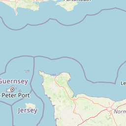
Map view of Kingmere Marine Conservation Zone

Use this park location map to pinpoint Kingmere Marine Conservation Zone in United Kingdom, understand its exact geographic position, and read its mapped placement within the surrounding landscape more clearly.

Pigeon | © OpenStreetMap contributors

Location context for Kingmere Marine Conservation Zone

West Sussex
Park atlas

Compare adjacent coastal waters, subtidal habitats, and regional conservation zones.

Explore Protected Areas and Marine Reserves Near Kingmere Marine Conservation Zone

Browse other marine protected areas and coastal habitats located near Kingmere Marine Conservation Zone. Comparing surrounding coastal ecosystems provides wider regional context for marine conservation in the English Channel.
Watercolor illustration of a coastal landscape featuring green hills, white cliffs, and a body of water
National parkSouth East England
About 12 km away#1 closest

North

South Downs National Park: A Distinctive Chalk Landscape in South East England's Atlas

Iconic chalk downland, coastal cliffs, and mapped terrain.

South Downs National Park is a premier protected landscape in South East England, celebrated for its unique chalk downland terrain and dramatic coastal formations. This page provides detailed geographic context for the park, highlighting its rolling hills, dry valleys, and ancient woodlands. Discover the park's mapped boundaries and its significance within England's protected areas, offering a structured atlas view for landscape exploration.

Area
1,627 km²
Established
2010
IUCN
V
Visitors
18M annual
Biosphere reserveSussex
About 29 km away#2 closest

Northeast

Brighton and Lewes Downs Biosphere Reserve: Geography and Protected Coastal Landscapes

Chalk downlands and marine ecosystems in Sussex

The Brighton and Lewes Downs Biosphere Reserve anchors a diverse range of protected habitats from the South Downs ridges to the English Channel seafloor. This mapped record details the terrestrial chalk grasslands, coastal cliffs, and rare offshore reef systems that characterize this notable biosphere reserve in Sussex. It serves as a comprehensive geographic reference for understanding the boundary between land-based conservation and marine habitat management.

Area
295.14 km²
Established
2014
Visitors
12M annual
Relief
Upland
Marine protected areaEast Sussex
About 38 km away#3 closest

East

Beachy Head West Marine Protected Area: Coastal Geography and Underwater Chalk Landscapes

Mapped protected seabed and marine geography in East Sussex

Investigate the marine landscape of Beachy Head West, a protected zone defined by its submerged chalk reefs and gullies extending from the East Sussex cliffs into the English Channel. This record highlights the site's distinct underwater topography, seabed mosaic, and its role as a core component of the regional marine conservation network across southeast England.

Area
24 km²
Established
2013
Relief
Lowland
Climate
Temperate
Watercolor painting showing a landscape with green and purple vegetation, a body of water, and distant hills.
National parkEngland
About 65 km away#4 closest

West

New Forest National Park: Historic Protected Landscape and Regional Geography in England

Mapped heathland, ancient woodlands, and pastoral traditions.

Explore New Forest National Park, a nationally significant protected area in England renowned for its unique blend of ancient royal forest history, traditional pastoral practices, and biologically rich lowland habitats. This page provides an atlas-focused view of its mapped boundaries, distinctive terrain, and geographic context within England, highlighting its value as a living landscape shaped by centuries of common grazing rights and supporting rare wildlife.

Area
566 km²
Established
2005
IUCN
V
Visitors
14.8M annual
Natural monumentIsle of Wight
About 80 km away#5 closest

West

The Needles Natural Monument: Coastal Chalk Geography and Protected Marine Landscapes

Geological formations and chalk headland terrain on the Isle of Wight

The Needles represents a unique geological intersection of vertical chalk strata and maritime history at the edge of the Isle of Wight. This protected area encompasses dramatic sea stacks, clifftop heathland, and critical marine habitats, offering a window into the complex coastal landscape of the English Channel and the regional geology of southern England.

Relief
Upland
Climate
Temperate
Access
Easy access
Scope
Mixed
Nature reserveSurrey
About 83 km away#6 closest

North

Wraysbury Reservoir: An Engineered Nature Reserve and Vital Wetland Habitat in Surrey

Examining infrastructure, ecology, and sonar testing geography.

Wraysbury Reservoir stands as a unique example of late-twentieth-century industrial landscape design, serving as both a primary London water resource and a protected Ramsar wetland. Its earthen embankments enclose a specialized environment where sonar research and ecological conservation coexist within the wider context of the Thames Valley. This record details the site's boundaries, its function as a wintering bird refuge, and its specialized role in UK marine testing.

Area
2.05 km²
Established
1970
Relief
Lowland
Climate
Temperate
Protected areaEngland
About 90 km away#7 closest

West

Dorset Heaths: Protected Lowland Landscapes and Regional Geography in Southern England

A comprehensive look at the Poole Basin heathland mosaic.

Spanning the Poole Basin, the Dorset Heaths offer a distinct geographic profile of acidic sands and diverse ecological mosaics. This protected area includes rare valley mires and coastal dunes, providing a clear window into the natural landscape history and ongoing conservation efforts within southern England's coastal regions.

Area
616.62 km²
Established
1998
Relief
Lowland
Water
Major water bodies
Watercolor painting of a coastline with rolling green cliffs meeting the sea, with small pink flowers in the foreground.
Protected landscapeUnited Kingdom
About 103 km away#8 closest

West

Jurassic Coast Protected Landscape: Geological Mapping and Coastal Atlas

A comprehensive look at sedimentary formations in the United Kingdom

Trace the 96-mile stretch of the Jurassic Coast, a protected landscape revealing Triassic, Jurassic, and Cretaceous rock layers. The terrain serves as a vital record of Earth history, featuring distinctive geomorphological landmarks like Chesil Beach and the towering cliffs of Golden Cap, all defined by the dynamic interaction of land and sea.

Established
2001
Relief
Upland
Climate
Temperate
Access
Easy access

Common questions about visiting, size, designation, and location context for Kingmere Marine Conservation Zone

Kingmere Marine Conservation Zone FAQs for park facts, access, geography, and protected area context

Find quick answers about Kingmere Marine Conservation Zone, including protected-area facts, park geography, trail and visitor context, and how the park fits into its surrounding country and regional landscape.
MoriAtlas Explorer

Continue Your Protected Areas Search Across the Global Atlas

Deepen your exploration by continuing the structured search for national parks and protected areas worldwide. Utilize the comprehensive filtering capabilities to compare different conservation landscapes and refine your understanding of global park geography. Discover more about the distribution and characteristics of protected natural areas.

Global natural geography