

Mori Atlas logo
National parkKinmen National Park

Discover the geographic context and protected area boundaries of this unique national park.

Kinmen National Park: A National Park in Kinmen County with Mapped Protected Landscape

(金門國家公園 (Jīnmén Guójiā Gōngyuán))

Kinmen National Park represents a distinct protected landscape within Kinmen County, Taiwan. As a national park, it offers a unique opportunity to explore its mapped boundaries and understand its place within the regional geography. This page serves as a gateway to understanding the park's protected natural identity and its context for atlas-based discovery.

migratory birdscoastal ecosystemswetlandsCold War historysubtropical parkisland protected area

Kinmen National Park

National park

Park overview

Structured park overview, official facts, and landscape profile for Kinmen National Park

Kinmen National Park park facts, protected area profile, and essential visitor context
Review the core facts for Kinmen National Park, including designation, size, terrain, visitor scale, habitats, and operating context in one park-focused overview.

About Kinmen National Park

Kinmen National Park occupies a singular position among Taiwan's protected areas, combining substantial ecological value with extraordinary historical significance on an archipelago that once stood at the forefront of Cold War tensions in East Asia. The park encompasses diverse landscapes including mountain ridges, coastal cliffs, tidal flats, and traditional villages, representing approximately a quarter of Kinmen County's total territory across its five designated management zones. Unlike many national parks that focus primarily on pristine wilderness, Kinmen National Park specifically addresses the challenge of preserving cultural landscapes where human settlement and military activity have shaped the terrain for centuries. The park's establishment in 1995 marked a significant turning point, transitioning the area from strict military control toward sustainable conservation and public access. Visitors to the park encounter a layered landscape where ancient coastal fortifications stand alongside traditional Fujian-style architecture, and where seasonal bird migrations create dynamic ecological displays across wetlands that have long been important to local communities. The park's management approach recognizes that Kinmen's natural values cannot be separated from its cultural history, leading to designations that protect both scenic areas and historical preservation zones within a unified framework.

Quick facts and research context for Kinmen National Park

Kinmen National Park occupies 35.29 square kilometers across the Kinmen archipelago in the Taiwan Strait, just kilometers from the Chinese mainland. The park was officially established on October 18, 1995, three years after martial law was lifted in the county. It is managed by the Kinmen National Park Headquarters under Taiwan's National Park Service. The park is divided into five main management zones: Taiwu Mountain, Kuningtou, Gugang, Mashan Hill, and Lieyu (Lesser Kinmen). The area experiences a subtropical climate that supports diverse habitats ranging from coastal wetlands to forested hills, making it particularly significant for seasonal bird migrations.

Park context

Deeper park guide and search-rich context for Kinmen National Park

Kinmen National Park history, landscape, wildlife, and travel context
Explore Kinmen National Park through its history, landscape character, ecosystems, wildlife, conservation priorities, cultural context, and seasonal travel timing in a structured park guide built for atlas discovery and search intent.

Why Kinmen National Park stands out

Kinmen National Park is best known as a premier birdwatching destination in Taiwan, with as many as 319 bird species documented within its boundaries. The park is particularly famous for seasonal waterfowl and shorebird migrations that transform its wetlands and coastal areas into bustling avian habitats each autumn and spring. It also preserves one of Taiwan's most extensive collections of Cold War-era military installations and fortifications, offering a unique window into the historical tensions between Taiwan and mainland China. The park's strategic location in the Taiwan Strait has shaped both its ecological patterns and its human history, creating a distinctive protected area where natural preservation meets living military heritage.

Kinmen National Park history and protected-area timeline

Kinmen National Park was established on October 18, 1995, representing one of Taiwan's more recent additions to its national park system. The timing of its creation is historically significant, occurring just three years after the lifting of martial law in Kinmen County, which had restricted civilian access to the archipelago for decades. Prior to the park's establishment, much of the territory remained under military administration due to Kinmen's strategic position in the Taiwan Strait and its proximity to the Chinese mainland. The park's creation reflected a broader shift in Taiwan's approach to conservation, expanding the national park system to include areas where natural and cultural heritage are deeply intertwined. The establishment also acknowledged that Kinmen's ecosystems, particularly its wetlands and coastal areas, had survived relatively intact precisely because of the long period of military restriction, creating conditions that were favorable for subsequent protection. Management authority rests with the Kinmen National Park Headquarters, operating under Taiwan's National Park Service and Ministry of the Interior.

Kinmen National Park landscape and geographic character

The landscape of Kinmen National Park is characterized by a varied terrain of hills, coastal formations, and wetland areas across the archipelago's main islands. Taiwu Mountain provides the park's highest elevation point, offering panoramic views of the surrounding archipelago and the Taiwan Strait. The coastal areas feature dramatic cliffs and rocky shores that contrast with sheltered tidal flats and beaches. Mashan Hill and the surrounding areas contain rolling terrain covered with mixed vegetation, while the Kuningtou area encompasses both historical sites and coastal landscapes. Gugang and Lieyu (Lesser Kinmen) extend the park's territory across the fragmented island group, adding diversity to the overall protected area. The park's landscapes reflect the geological characteristics of the Kinmen area, which consists primarily of igneous and metamorphic bedrock similar to the adjacent mainland Fujian coast. Traditional settlement patterns with characteristic Fujian architecture are embedded throughout the landscape, creating cultural landmarks within the natural terrain.

Kinmen National Park ecosystems, habitats, and plant life

The ecological character of Kinmen National Park is defined by its subtropical climate, coastal wetland systems, and its critical role as a migratory bird corridor. The park's wetlands and coastal areas become particularly important during the autumn and spring migration seasons, when thousands of birds use the area as a staging ground between their breeding grounds in the north and wintering areas to the south. The diverse habitats within the park support a range of vegetation types including coastal grasslands, shrublands, and forested areas on the hillsides. The park's isolation from Taiwan proper and its proximity to the mainland have influenced the distribution of species, with some植物 and animal populations showing closer affinity to mainland Fujian than to the rest of Taiwan. The relatively low human population density within the park boundaries, combined with decades of restricted access during the martial law period, contributed to the preservation of natural habitats that might otherwise have been developed. This combination of geographic position, habitat diversity, and historical protection has created conditions that support exceptional bird diversity.

Kinmen National Park wildlife and species highlights

Kinmen National Park is renowned for its remarkable bird diversity, with as many as 319 bird species recorded within its boundaries. The park's wetlands and coastal areas serve as crucial staging and wintering grounds for migratory waterfowl and shorebirds traveling the East Asian-Australasian flyway. Seasonal concentrations of ducks, geese, swans, and waders can be observed during migration peaks, making the park a significant destination for birdwatchers and ornithologists. The coastal waters support marine birds including terns, gulls, and cormorants, while the forested and shrubland areas provide habitat for land birds including various passerines and raptors. The park's position at the edge of the Taiwan Strait means that species from both mainland Asia and Taiwan proper can be found within its boundaries, creating an unusual mix of zoogeographic influences. Beyond birds, the park supports various other wildlife including reptiles, amphibians, and insects that inhabit the diverse terrestrial and wetland environments.

Kinmen National Park conservation status and protection priorities

Kinmen National Park represents an important conservation designation in Taiwan's network of protected areas, addressing both the ecological significance of the archipelago and its irreplaceable cultural heritage. The park's designation as an IUCN Category II protected area reflects its primary function of preserving natural ecosystems while allowing for compatible human uses and environmental education. The protection of migratory bird habitats is a particularly significant conservation priority, as the East Asian-Australasian flyway faces increasing pressures from development and habitat loss across the region. Kinmen's wetlands and coastal areas provide critical rest stops and feeding grounds for birds traveling between their breeding and wintering areas, making international cooperation in conservation efforts particularly relevant. The park's management also addresses the challenge of preserving historical structures and military installations while maintaining ecological integrity, a unique approach that recognizes the intertwined nature of Kinmen's natural and cultural landscapes. Public education and sustainable tourism are integrated into the conservation framework, allowing visitors to appreciate the park's values while minimizing impacts on sensitive habitats.

Kinmen National Park cultural meaning and human context

Kinmen National Park contains a distinctive cultural landscape shaped by centuries of human settlement and several decades of military significance. The Kinmen archipelago has historically been closely connected to the Fujian Province mainland, and this relationship is reflected in the traditional architecture, dialect, and cultural practices of local communities. The park preserves numerous historical structures including traditional Fujian-style residences, temples, and public buildings that reflect the area's heritage as part of the Minnan cultural region. More recent history is represented by extensive military fortifications, tunnels, and installations from the Cold War period, when Kinmen served as a front-line outpost in the conflict between the Republic of China and the People's Republic of China. The Kuningtou area contains particularly significant historical sites related to the 1949 battle that marked a turning point in the Chinese Civil War. This layering of cultural periods, from traditional settlements to military installations, creates a cultural context that is inseparable from the park's natural landscapes and adds historical depth to the visitor experience.

Top sights and standout views in Kinmen National Park

Kinmen National Park offers a distinctive combination of ecological and historical attractions that set it apart from Taiwan's other protected areas. The seasonal bird migrations, particularly during autumn and spring, create spectacular wildlife viewing opportunities across the park's wetlands and coastal areas, with hundreds of species present during peak periods. The preserved military heritage sites, including fortifications, tunnels, and command centers, provide unique insights into the Cold War history of the Taiwan Strait and are a major draw for visitors interested in military history. Traditional settlements with well-preserved Fujian architecture offer cultural appreciation opportunities, while the park's hills and coastal areas provide scenic landscapes and recreational access. The park's role as a conservation area protecting critical migratory bird habitat in the East Asian-Australasian flyway adds international significance to its ecological mission.

Best time to visit Kinmen National Park

The optimal time to visit Kinmen National Park depends on visitor interests, with different seasons offering distinct experiences. Autumn and spring coincide with the peak migratory bird seasons, when the park's wetlands host the greatest diversity and abundance of birds, making these periods ideal for birdwatching and wildlife observation. The subtropical climate means that temperatures are moderate during these seasons, though visitors should be prepared for variable weather. Summer months bring warmer temperatures and can be less comfortable for extensive outdoor activities, though this period offers longer daylight hours for exploration. Winter, while cooler, still provides access to the park and may offer opportunities to observe wintering bird species. Visitors interested in the historical and cultural aspects of the park can find meaningful experiences throughout the year, though the shoulder seasons of spring and autumn generally offer the most favorable conditions for combining wildlife viewing with comfortable weather for walking and exploration.

Park location guide

Geography guide, regional context, and park location map for Kinmen National Park

Kinmen National Park park geography, regions, and map view in Taiwan
Understand where Kinmen National Park sits in Taiwan through a broader geographic reading of the surrounding landscape, nearby location context, and its mapped position within the national park landscape.

How Kinmen National Park fits into Taiwan

Taiwan is an island nation in East Asia situated between the East China Sea and South China Sea. With a population of approximately 23.3 million people, it is one of the most densely populated countries in the world. The island features mountain ranges dominating its eastern region and densely populated plains in the west, where major cities including Taipei and New Taipei City are located.

Wider geography shaping Kinmen National Park in Taiwan

Taiwan is located in the western Pacific Ocean, bordered by the East China Sea to the northwest and the South China Sea to the southwest. The People's Republic of China lies to the northwest across the Taiwan Strait, Japan is to the northeast, and the Philippines are to the south. The main island features mountain ranges dominating the eastern two-thirds of the territory, with plains concentrated in the western third where the majority of the population resides.

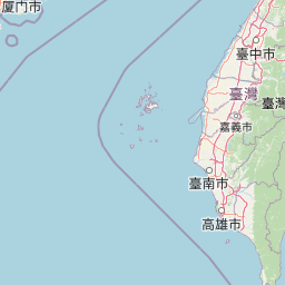
Map view of Kinmen National Park

Use this park location map to pinpoint Kinmen National Park in Taiwan, understand its exact geographic position, and read its mapped placement within the surrounding landscape more clearly.

Pigeon | © OpenStreetMap contributors

Location context for Kinmen National Park

Kinmen County
Park atlas

Trace diverse coastal ecosystems and historical sites across the Kinmen archipelago and surrounding protected landscapes.

Explore Related National Parks and Protected Areas Near Kinmen Archipelago
Continue your exploration from Kinmen National Park by browsing nearby protected areas and comparing their geographic spread across the broader Taiwan Strait region. Identify common coastal ecosystems, historical sites, and migratory bird habitats, tracing how conservation efforts connect different protected landscapes.
National parkTaiwan

South Penghu Marine National Park: A Protected Volcanic Island Landscape in Taiwan's Penghu Archipelago

Mapped marine protected areas and unique geological features.

Discover the unique atlas value of South Penghu Marine National Park, Taiwan's protected national park renowned for its dramatic columnar basalt landforms and extensive coral reef systems. This marine protected area provides critical habitat for diverse species and showcases a rugged island geography shaped by volcanic activity. Explore its mapped boundaries and unique geological formations, including famous sea caves, offering a distinct context for landscape discovery.

Area
358.44 km²
Established
2014
IUCN
II
Visitors
8.4K annual
National parkTainan

Taijiang National Park: National Park Atlas and Protected Landscape Exploration

Discover mapped boundaries and regional geography.

Taijiang National Park offers a distinct look into protected natural landscapes within Tainan, Taiwan. This page details its identity as a national park, focusing on its mapped geographic features and its contribution to the regional atlas. Users can explore the specific protected area context and understand the landscape characteristics relevant to a structured geographic discovery approach.

Area
393.1 km²
Established
2009
IUCN
II
Relief
Lowland
National parkMiaoli County

Shei-Pa National Park: Explore Taiwan's National Park Protected Landscape in Miaoli County

Mapped geographic boundaries and regional park context.

Shei-Pa National Park is a vital protected area in Miaoli County, Taiwan, offering rich opportunities for geographic and atlas-based exploration. Delve into the specifics of its mapped park boundaries and understand its role within the broader regional landscape. This destination provides essential context for discovering Taiwan's protected natural areas and their unique geographic characteristics.

Area
768.5 km²
Established
1992
IUCN
II
Relief
Mountain
National parkNantou County

Yushan National Park: Explore Taiwan's Highest Mountain and Alpine Protected Terrain

Mapped geography and dramatic peaks within Nantou County.

Yushan National Park is a crucial protected area in Taiwan, renowned for encompassing the island's highest mountain and a significant portion of the Central Mountain Range. This national park's dramatic geography spans over 103,000 hectares, with two-thirds of its territory lying above 2,000 meters. Its vertical ecological zones, from subtropical forests to alpine environments, offer a rich tapestry of landscapes ideal for atlas-style exploration of protected terrain and mountain peak geography.

Area
1,031.21 km²
Established
1985
IUCN
II
Visitors
1M annual
National parkHualien County

Taroko National Park: Detailed National Park Geography and Protected Landscape Context

Explore mapped boundaries and natural terrain in Hualien County.

Taroko National Park represents a significant protected landscape within Taiwan, offering rich opportunities for geographical exploration and understanding protected-area distribution. As a designated national park, its mapped boundaries and unique terrain provide essential context for appreciating the natural geography of Hualien County and the surrounding region. This page supports detailed discovery of Taroko National Park's identity as a distinct protected area, ideal for atlas-based research and landscape comprehension.

Area
920 km²
Established
1986
IUCN
II
Relief
Mountain
National parkTaiwan

Yangmingshan National Park: Volcanic Terrain and Geothermal Features Atlas

Explore Taiwan's protected national park geography and mapped landscapes.

Yangmingshan National Park presents a striking example of volcanic geography, characterized by its rugged mountain terrain, active craters like Xiaoyoukeng, and ubiquitous geothermal features such as hot springs and sulfur deposits. As a protected national park within Taiwan, its landscape offers a rich context for understanding volcanic processes and alpine ecosystems. MoriAtlas provides detailed map exploration of Yangmingshan National Park, highlighting its unique geological formations and protected boundaries for an in-depth geographic discovery experience.

Area
113 km²
Established
1985
IUCN
II
Protected landscapeFujian

Wuyi Mountains Protected Landscape: A Geographic Atlas of Subtropical Forests and Danxia Terrain

Mapped boundaries, regional geography, and ancient landscape context.

The Wuyi Mountains in Fujian, China, are a crucial protected landscape, recognized for their exceptional subtropical forest biodiversity and iconic Danxia landforms. This destination offers a detailed exploration of its mapped geography, including the striking red sandstone cliffs, meandering river valleys, and significant cave systems. Understand the park's protected boundaries and its role as a vital natural and cultural heritage site within China's regional geography, perfect for atlas-based discovery.

Area
1,278.63 km²
Established
1999
IUCN
II
Relief
Mountain
National parkPingtung County

Kenting National Park: Taiwan's Southern National Park Protected Landscape Identity

Mapped geography and regional context for this protected area.

Kenting National Park is a crucial protected area located in Pingtung County, Taiwan, representing a significant component of the nation's protected lands. This page provides detailed information ideal for atlas-driven exploration, focusing on the park's mapped geographic features, its role as a national park, and its contribution to understanding Taiwan's diverse landscapes. Discover the unique identity of Kenting National Park as a key element in regional conservation and geographic study.

Area
333 km²
Established
1984
IUCN
II
Visitors
5.8M annual

Common questions about visiting, size, designation, and location context for Kinmen National Park

Kinmen National Park FAQs for park facts, access, geography, and protected area context
Find quick answers about Kinmen National Park, including protected-area facts, park geography, trail and visitor context, and how the park fits into its surrounding country and regional landscape.
MoriAtlas Explorer

Continue Your Protected Areas Search Across the Global Atlas

Deepen your exploration by continuing the structured search for national parks and protected areas worldwide. Utilize the comprehensive filtering capabilities to compare different conservation landscapes and refine your understanding of global park geography. Discover more about the distribution and characteristics of protected natural areas.

Global natural geography
