

Mori Atlas logo
National parkKirindy Mitea National Park

Understand Kirindy Mitea National Park's geographic boundaries and protected area context within Madagascar.

Kirindy Mitea National Park: Madagascar's Protected Landscape and National Park Atlas Entry

Kirindy Mitea National Park represents a significant protected area within the island geography of Madagascar. As a designated national park, its mapped boundaries contribute to the country's unique landscape tapestry. This page offers a structured gateway to understanding Kirindy Mitea National Park's place in the atlas, focusing on its role as a protected natural landscape for geographic discovery and regional context.

dry deciduous forestspiny forestlemurscoastal protected areaMadagascarisland conservation

Kirindy Mitea National Park

National park

Park overview

Structured park overview, official facts, and landscape profile for Kirindy Mitea National Park

Kirindy Mitea National Park park facts, protected area profile, and essential visitor context
Review the core facts for Kirindy Mitea National Park, including designation, size, terrain, visitor scale, habitats, and operating context in one park-focused overview.

About Kirindy Mitea National Park

Kirindy Mitea National Park represents one of Madagascar's most significant protected coastal ecosystems, spanning the transition zone between southern and western biogeographic regions. The park's coastal position along the Mozambique Channel provides it with both terrestrial and marine conservation value, encompassing seven small islands within its marine boundary. The landscape supports Madagascar's largest remaining contiguous area of dry deciduous forest, a habitat type that has been heavily degraded across the island due to agricultural expansion and logging. Beyond the forests, the park incorporates spiny forest characterised by succulent plants and thorny vegetation adapted to the semi-arid conditions, beaches and sand dunes along the coastline, mangrove systems, and coral reef environments. This habitat diversity creates ecological niches supporting extraordinary endemism, with the vast majority of the park's vertebrate species found nowhere else on Earth.

Quick facts and research context for Kirindy Mitea National Park

Kirindy Mitea spans roughly 72,200 hectares along the Mozambique Channel coast in Madagascar's Menabe Region, positioned south of Morondava. The park was established in 1997 and is managed by Madagascar National Parks Association. It features a unique convergence of southern and western biotypes, creating varied habitats within a single protected area. The park contains the largest remaining tract of dry deciduous forest in Madagascar and supports eleven mammal species, of which ten are endemic to the region.

Park context

Deeper park guide and search-rich context for Kirindy Mitea National Park

Kirindy Mitea National Park history, landscape, wildlife, and travel context
Explore Kirindy Mitea National Park through its history, landscape character, ecosystems, wildlife, conservation priorities, cultural context, and seasonal travel timing in a structured park guide built for atlas discovery and search intent.

Why Kirindy Mitea National Park stands out

Kirindy Mitea is most celebrated for its extraordinary primate population, including eight documented lemur species within its boundaries. The park is the only known location of Madame Berthe's mouse lemur, the world's smallest primate. It also hosts the fossa, Madagascar's largest living terrestrial predator and the primary natural predator of lemurs. The park's diverse habitats range from dense dry forests to spiny thorn woodland, mangroves, and coral reef environments, creating an ecological mosaic that supports remarkable biodiversity.

Kirindy Mitea National Park history and protected-area timeline

Kirindy Mitea National Park was officially established on 18 December 1997, recognising the ecological significance of the Menabe region's unique coastal forests and the urgent need to protect Madagascar's vanishing dry forest ecosystems. The park's creation came during a period of increased conservation attention for Madagascar's western coastal zones, which had been subject to extensive deforestation throughout the twentieth century. Management responsibilities were assigned to Madagascar National Parks Association, the country's primary protected area management body. The park's establishment also acknowledged the region's cultural significance, as the Sakalava people have inhabited this coastal zone for centuries, shaping the landscape through traditional land use practices.

Kirindy Mitea National Park landscape and geographic character

The terrain of Kirindy Mitea encompasses a remarkable variety of landforms within a relatively compact protected area. The terrestrial landscape is dominated by dry deciduous forest in the more humid zones, giving way to spiny forest in the drier southern portions where drought-resistant succulent plants and thorny vegetation prevail. The park's coastal fringe features sandy beaches and active sand dunes that shift with seasonal wind patterns. Inland, the terrain is intersected by river systems including the Maharivo River and Lampaolo River, which create seasonal wetlands and influence the distribution of forest types. The marine component includes seven islands distributed along the coastal margin, each supporting distinct vegetation communities and serving as important nesting sites for seabirds and marine turtles.

Kirindy Mitea National Park ecosystems, habitats, and plant life

The ecological character of Kirindy Mitea reflects its position at the convergence of Madagascar's southern and western biogeographic provinces, creating a unique blend of species assemblages. The park's dry deciduous forests represent the largest remaining intact example of this forest type in Madagascar, supporting a complex community of endemic species adapted to seasonal drought conditions. The forest structure features dense canopy layers and a diverse understory of flowering plants and ferns. Spiny forest areas contain specialised xerophytic vegetation including numerous endemic baobab species, with three baobab species recorded within park boundaries. The mangrove systems along tidal channels support seven tree species adapted to saline conditions and provide critical nursery habitat for marine species. Coral reef environments in the shallow coastal waters add another dimension to the park's ecological diversity.

Kirindy Mitea National Park wildlife and species highlights

The mammalian fauna of Kirindy Mitea demonstrates exceptional levels of endemism, with ten of eleven recorded species found exclusively in this region. The park's eight lemur species represent a significant portion of Madagascar's total lemur diversity and include the critically endangered Madame Berthe's mouse lemur, the smallest primate species in the world, which has only been documented within this park. The fossa serves as the apex predator, preying primarily on lemurs and maintaining ecological balance within the forest communities. Other endemic mammals include the giant jumping rat and the narrow-striped mongoose, both restricted to the Menabe region. Bird diversity includes forty-seven species with thirty-three endemic to Madagascar, while twenty-three reptile species have been recorded, including the Malagasy giant hognose snake.

Kirindy Mitea National Park conservation status and protection priorities

Kirindy Mitea represents a critical conservation priority due to the unprecedented levels of endemism within its boundaries and the threat pressure facing Madagascar's dry forest ecosystems. The park's designation as an IUCN Category IV protected area reflects its management focus on habitat and species conservation rather than strict preservation. The conservation challenge is heightened by the region's seasonal climate patterns, with the warm dry season from March through November causing widespread dormancy among wildlife and leaf loss in trees, creating a vulnerable period for ecosystem stress. The park's marine component adds complexity to conservation planning, requiring integrated coastal zone management approaches that address both terrestrial and marine threats. The presence of the world's smallest primate within its boundaries gives Kirindy Mitea particular global conservation significance.

Kirindy Mitea National Park cultural meaning and human context

The human landscape surrounding Kirindy Mitea is shaped by the Sakalava people, the dominant ethnic group of Madagascar's western coastal regions. The Sakalava have maintained traditional land use practices in this area for centuries, including rotational agriculture and seasonal grazing that have influenced forest composition and structure. Traditional fishing communities utilise the coastal waters and islands, maintaining livelihoods intimately connected to the marine ecosystems the park protects. Access to the park remains seasonal, with the most practical overland routes via the provincial road from Bemanonga and Belo sur Mer only accessible from May through November, reflecting traditional patterns of movement tied to rainfall patterns and agricultural cycles.

Top sights and standout views in Kirindy Mitea National Park

Kirindy Mitea offers access to one of the world's highest primate density areas, with the unique opportunity to observe the tiny Madame Berthe's mouse lemur, found nowhere else. The park's diverse habitats can be explored through both terrestrial walking trails and marine excursions to the offshore islands. The seasonal transformation between dry and rainy seasons creates dramatically different visitor experiences, with the wet season bringing active wildlife, green vegetation, and birth cycles among lemur populations. The coastal setting provides opportunities for reef exploration and birdwatching, with thirty-three endemic bird species present.

Best time to visit Kirindy Mitea National Park

The optimal visiting period coincides with the rainy season from December through February, when temperatures moderate from the extreme heat of the dry season and wildlife becomes more active following the dormancy period. During the rainy season, the forest transforms from brown and leafless to vibrant green, lemurs become more visible as they forage actively, and many species give birth to young. The dry season from March through November presents a more challenging landscape, with much of the fauna entering hibernation-like states and vegetation appearing dormant. However, the dry season's clearer conditions and reduced humidity may appeal to visitors seeking a different wilderness experience, and the famous spiny forest landscapes retain their stark beauty year-round.
Park location guide

Geography guide, regional context, and park location map for Kirindy Mitea National Park

Kirindy Mitea National Park park geography, regions, and map view in Madagascar
Understand where Kirindy Mitea National Park sits in Madagascar through a broader geographic reading of the surrounding landscape, nearby location context, and its mapped position within the national park landscape.

How Kirindy Mitea National Park fits into Madagascar

Madagascar is an island nation in the Indian Ocean, positioned off the southeastern coast of Africa. As the world's fourth-largest island and second-largest island country, it stands out for its exceptional biodiversity, over 90% of its wildlife is endemic, making it one of 17 megadiverse countries. The population is approximately 32 million, with Antananarivo as both the capital and largest city.

Wider geography shaping Kirindy Mitea National Park in Madagascar

Madagascar lies in the Indian Ocean off the southeastern coast of Africa, separated from the mainland by the Mozambique Channel. The island is situated approximately 400 km from the African continent. As the world's fourth-largest island, it also includes numerous smaller peripheral islands.

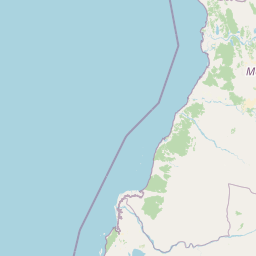
Map view of Kirindy Mitea National Park

Use this park location map to pinpoint Kirindy Mitea National Park in Madagascar, understand its exact geographic position, and read its mapped placement within the surrounding landscape more clearly.

Pigeon | © OpenStreetMap contributors

Location context for Kirindy Mitea National Park

Menabe
Park atlas

Compare diverse coastal protected areas and unique inland ecosystems across Madagascar's western region

Discover Other National Parks and Protected Areas Near Kirindy Mitea National Park
Browse other protected areas and national parks that share the unique coastal and terrestrial landscapes found around Kirindy Mitea National Park. Discover how Madagascar's rich biodiversity is preserved across different regional park geographies, allowing for comparative ecological study.
National parkAtsimo-Andrefana

Zombitse-Vohibasia National Park: Protected Landscape and Regional Geographic Context

Mapped protected areas and natural terrain discovery.

Investigate Zombitse-Vohibasia National Park, a designated national park within the Atsimo-Andrefana region. This dedicated entry provides detailed geographic information, focusing on the park's mapped terrain and its contribution to the regional protected landscape. Gain insight into the park's atlas-relevant features and its specific place within Madagascar's conservation geography.

Area
363.08 km²
Established
2002
IUCN
II
Relief
Upland
National parkIhorombe Region

Isalo National Park: Explore Madagascar's Sandstone Canyons and Protected Landscape Geography

Discover unique geology, tapia woodlands, and regional park context.

Isalo National Park is a prominent protected area in Madagascar's Ihorombe Region, celebrated for its spectacular sandstone landscape. This national park features deep canyons, eroded rock domes, and striking runiform mountains, formed from ancient sedimentary deposits. The park preserves significant tapia woodlands and remarkable plant endemism, offering a rich context for understanding protected land distribution and Madagascar's unique geography. Its mapped terrain provides a visual atlas of natural wonders.

Area
815.4 km²
Established
1962
IUCN
II
Visitors
32.7K annual
National parkMelaky

Tsingy de Bemaraha National Park: A Protected Landscape within Melaky, Madagascar

Explore mapped boundaries and regional geography for atlas discovery.

Tsingy de Bemaraha National Park is a designated national park offering profound opportunities for geographic discovery. As a key protected area in the Melaky region, its mapped boundaries and natural landscape characteristics are vital for understanding Madagascar's conservation geography. This resource facilitates detailed atlas exploration, providing structured insights into the park's terrain and its position within the broader regional context, enabling a focused study of its protected land identity.

Area
723.4 km²
Established
1997
IUCN
II
Visitors
10.1K annual
National parkHaute Matsiatra

Andringitra National Park: A Protected Landscape within Haute Matsiatra's Geography

Explore mapped park boundaries and regional terrain.

Andringitra National Park represents a vital protected area within the Haute Matsiatra region, contributing significantly to the mapped landscape of central Madagascar. Its designation as a national park underscores its importance for conservation and geographic study. Users exploring this destination can gain a detailed understanding of its specific protected boundaries, the surrounding natural terrain, and its overall contribution to the regional geography, making it a key site for atlas-based landscape discovery.

Area
311.6 km²
Established
1999
IUCN
II
Visitors
3.4K annual
National parkMadagascar

Ranomafana National Park: Madagascar's premier Tropical Rainforest Protected Area

Explore its unique mapped geography and landscape context.

Ranomafana National Park stands as a crucial national park within Madagascar's protected lands, safeguarding a significant expanse of tropical rainforest. This page offers a deep dive into its geographic setting, detailing the mapped boundaries and the distinctive natural terrain that supports its exceptional biodiversity. Discover the atlas value of this protected landscape for understanding regional conservation and geographic context.

Area
416 km²
Established
1991
IUCN
II
Climate
Tropical
National parkMadagascar

Marolambo National Park: Madagascar's National Park and Protected Landscape

Explore mapped boundaries and regional geography.

Marolambo National Park stands as a protected national park within Madagascar's globally recognized biodiversity hotspot. This entry provides focused insight into its protected landscape, its specific geographic context within the island nation, and its role in the conservation of unique natural terrain. Understanding Marolambo National Park through its mapped boundaries and regional geography contributes to a broader atlas exploration of Madagascar's endemic ecosystems.

Area
950.63 km²
Climate
Tropical
Access
Remote access
Scope
Terrestrial
National parkAtsimo-Atsinanana

Midongy du sud National Park: National Park in Atsimo-Atsinanana, Madagascar

Explore its protected landscape and mapped geography.

Midongy du sud National Park is a significant protected area located in the Atsimo-Atsinanana region of Madagascar. This entry provides detailed geographic context, focusing on the park's mapped boundaries and its identity as a national park. It supports atlas-based discovery by offering insights into the park's specific landscape and its regional setting within southeastern Madagascar, serving as a factual resource for understanding its protected status.

Area
1,922 km²
Established
1997
IUCN
II
Relief
Mountain
National parkAlaotra-Mangoro

Andasibe-Mantadia National Park: National Park and Protected Landscape Identity

Explore its mapped boundaries and geographic context.

Andasibe-Mantadia National Park is a distinct protected territory within the Alaotra-Mangoro region, serving as a crucial focal point for understanding Madagascar's regional geography and protected land distribution. This detail page provides essential atlas-style information on the park's mapped area and its natural landscape characteristics. Engage with structured data that highlights the park's protected status and its position within the broader geographic framework of eastern Madagascar, supporting focused discovery for researchers and explorers.

Area
155 km²
Established
1989
IUCN
II
Visitors
26.1K annual

Common questions about visiting, size, designation, and location context for Kirindy Mitea National Park

Kirindy Mitea National Park FAQs for park facts, access, geography, and protected area context
Find quick answers about Kirindy Mitea National Park, including protected-area facts, park geography, trail and visitor context, and how the park fits into its surrounding country and regional landscape.
MoriAtlas Explorer

Continue Your Protected Areas Search Across the Global Atlas

Deepen your exploration by continuing the structured search for national parks and protected areas worldwide. Utilize the comprehensive filtering capabilities to compare different conservation landscapes and refine your understanding of global park geography. Discover more about the distribution and characteristics of protected natural areas.

Global natural geography