

Mori Atlas logo
Nature reserveKojonup Reserve

A vital remnant of native bushland serving as an ecological refuge in the Shire of Kojonup

Kojonup Reserve: Understanding Protected Wandoo Woodland Geography in Western Australia

Kojonup Reserve encompasses 389 hectares of undulating terrain in the south-west of Western Australia, providing critical protection for remnant wandoo woodland. This nature reserve functions as a self-contained bushland refuge amidst a landscape dominated by agricultural activity. By maintaining continuous tree cover and native understorey, the area serves as a significant link in the regional network of protected environments.

wandoo woodlandnature reserveBush Heritage Australiasouth-west Western Australiawoodland birdsprivate conservation reserve

Kojonup Reserve

Nature reserve

Park overview

Structured park overview, official facts, and landscape profile for Kojonup Reserve

Kojonup Reserve park facts, protected area profile, and essential visitor context

Review the core facts for Kojonup Reserve, including designation, size, terrain, visitor scale, habitats, and operating context in one park-focused overview.

About Kojonup Reserve

Kojonup Reserve sits in the rural south-west of Western Australia, within a landscape that has been extensively modified for farming since European settlement. Spread across 389 hectares near Cherry Tree Pool in the Shire of Kojonup, the reserve provides a substantial block of relatively intact native vegetation in a region where most of the original woodland cover has been cleared.

The reserve is privately owned and managed by Bush Heritage Australia, a non-profit conservation organisation that acquires and manages land of high ecological value. Kojonup Reserve was purchased in 1996, adding it to a portfolio of properties aimed at preserving Australia's natural heritage through private land stewardship. It sits adjacent to the Birdwood Nature Reserve, increasing its functional landscape value as part of a broader network of bushland in the area.

Ecologically, the reserve is significant because it conserves a representative example of wandoo woodland, a tree-dominated ecosystem characteristic of parts of the Western Australian wheatbelt and surrounding regions. This habitat type has been progressively reduced over time, and surviving large blocks such as Kojonup Reserve play an important role in maintaining biodiversity at a regional scale. The reserve also supports typical south-west Australian woodland fauna, including macropods, possums and a wide range of bird species, making it a useful reference site for understanding the natural values that the surrounding agricultural landscape once supported.

Quick facts and research context for Kojonup Reserve

Kojonup Reserve is a nature reserve in south-west Western Australia. It is owned and managed by Bush Heritage Australia and was acquired by the organisation in 1996. The reserve covers about 389 hectares and is positioned within the Shire of Kojonup, near the small locality of Cherry Tree Pool, with the Birdwood Nature Reserve bordering it to the south-west. Its primary conservation role is the protection of remnant wandoo woodland and the associated woodland wildlife of the region.

Protection and recognition

Examine the terrestrial protected area designation and management scope for Kojonup Reserve.

Kojonup Reserve Protection Status and International Recognition Data

Kojonup Reserve maintains a documented terrestrial protection scope within the regional conservation framework. Structured records outline the official status and international recognition details associated with the protected landscape.

Protection details

Protection scope
Terrestrial
Transboundary protection
No
Park context

Deeper park guide and search-rich context for Kojonup Reserve

Kojonup Reserve history, landscape, wildlife, and travel context

Explore Kojonup Reserve through its history, landscape character, ecosystems, wildlife, conservation priorities, cultural context, and seasonal travel timing in a structured park guide built for atlas discovery and search intent.

Why Kojonup Reserve stands out

Kojonup Reserve is best known for protecting one of the few surviving remnants of wandoo woodland in south-west Western Australia. The reserve is a Bush Heritage Australia property, acquired specifically to safeguard this increasingly rare ecological community and its associated wildlife from further clearing.

Kojonup Reserve history and protected-area timeline

Kojonup Reserve was purchased by Bush Heritage Australia in 1996, establishing it as a privately managed conservation property within the organisation's expanding network of nature reserves across Australia. The acquisition reflected growing recognition of the plight of wandoo woodland in south-west Western Australia, much of which had been cleared for agriculture throughout the twentieth century.

Since its purchase, the reserve has been managed by Bush Heritage Australia as a dedicated conservation area, with the surrounding Birdwood Nature Reserve providing additional landscape connectivity. Over time, the reserve has become one of a number of private conservation properties in the south-west that exist to protect remaining native vegetation and associated wildlife in an otherwise heavily cleared farming landscape.

Kojonup Reserve landscape and geographic character

The reserve occupies gently undulating terrain characteristic of the south-west Western Australian countryside, with soils and landforms that once supported extensive wandoo woodland vegetation. Today, the surrounding region is dominated by cleared farmland, pasture and small remnants of bushland, making the reserve's continuous tree cover a visually distinct patch in the local landscape.

Within the reserve, the landscape takes on the typical character of wandoo woodland, with a canopy of mature wandoo trees over an understorey of smaller native plants and leaf litter. The topography is modest, and the reserve functions as a relatively self-contained bushland refuge surrounded by the broader rural land use pattern of the Shire of Kojonup.

Kojonup Reserve ecosystems, habitats, and plant life

Kojonup Reserve protects a remnant of wandoo woodland, an ecological community that has become increasingly rare across the south-west of Western Australia. Wandoo trees form the structural backbone of the woodland, creating a tall, open eucalypt canopy that shades a diverse understorey of native shrubs, herbs and ground cover plants.

This type of woodland provides essential habitat for a wide range of native animals, particularly bird species and arboreal mammals that rely on tree hollows, bark fissures and leaf litter for shelter and food. By maintaining a substantial block of this habitat in a largely cleared landscape, the reserve contributes to regional biodiversity conservation and acts as a refuge for woodland species that have declined elsewhere in the south-west.

Kojonup Reserve wildlife and species highlights

The reserve supports typical south-west Australian woodland fauna, with several common mammal species recorded within its boundaries. Western grey kangaroos are regularly present in the open woodland habitat, and western brush wallabies occur in the area. Common brushtail possums use tree hollows and dense foliage in the wandoo canopy for shelter.

The woodland bird community is particularly varied, with multiple small passerines feeding and nesting among the trees. Species recorded from the reserve include scarlet robins, red-capped robins and western yellow robins, as well as jacky winter, a familiar woodland flycatcher. The presence of the colourful regent parrot, a species associated with south-west woodland habitat, is also noted. Together, this mix of mammals and birds reflects the ecological value of the reserve's wandoo woodland and its role as a refuge for wildlife in a fragmented rural landscape.

Kojonup Reserve conservation status and protection priorities

Kojonup Reserve is of significant conservation value because it protects one of the few remaining stands of wandoo woodland in south-west Western Australia. Large-scale clearing for agriculture has dramatically reduced the extent of this woodland type across its former range, and surviving intact blocks such as the reserve are now disproportionately important for the persistence of associated species.

The reserve is privately managed by Bush Heritage Australia, an organisation that acquires and conserves land of high biodiversity value through private ownership and stewardship. By maintaining the reserve in its natural state, controlling threats such as grazing pressure, and protecting habitat connectivity with the adjacent Birdwood Nature Reserve, the property contributes to broader efforts to conserve native vegetation and wildlife across the heavily cleared agricultural landscapes of southern Western Australia.

Top sights and standout views in Kojonup Reserve

Kojonup Reserve stands out as a Bush Heritage Australia property dedicated to conserving wandoo woodland, an ecological community now reduced to fragments across south-west Western Australia. Its 389-hectare size gives it meaningful value as a refuge in a heavily cleared agricultural landscape, while its adjacency to the Birdwood Nature Reserve enhances its role as part of a broader network of protected bushland in the Shire of Kojonup.

Best time to visit Kojonup Reserve

As a privately managed bushland reserve in south-west Western Australia, Kojonup Reserve is best experienced during the cooler and drier months of late autumn, winter and spring, when mild temperatures and steady rainfall bring the wandoo woodland to life and increase the chance of observing woodland birds and active native animals. Summer in the region can be hot and dry, with elevated bushfire risk, which may affect both visitor conditions and seasonal access.
Monthly climate preview

Long-term monthly temperature averages and precipitation records for Kojonup Reserve

Kojonup Reserve Climate Normals: Annual Temperature and Precipitation Profiles

Historical climate data from 1991 to 2020 documents monthly temperature variations and precipitation patterns across Kojonup Reserve. Detailed monthly breakdowns provide deeper insight into long-term environmental norms for the protected area.
Annual mean16 °C
9 °C23 °C
Jan23°
Feb22°
Mar20°
Apr17°
May13°
Jun10°
Jul
Aug10°
Sep11°
Oct15°
Nov18°
Dec21°
Warmest month
January

22.6 °C

Coolest month
July

9.4 °C

Wettest month
July

2 mm/day

Driest month
February

0.6 mm/day

Park location guide

Geography guide, regional context, and park location map for Kojonup Reserve

Kojonup Reserve park geography, regions, and map view in Australia

Understand where Kojonup Reserve sits in Australia through a broader geographic reading of the surrounding landscape, nearby location context, and its mapped position within the national park landscape.

How Kojonup Reserve fits into Australia

Australia is a constitutional monarchy and federal parliamentary democracy comprising six states and ten territories. With a population of nearly 28 million, it is one of the world's most urbanised countries, with most people concentrated on the eastern seaboard. The country has a high Human Development Index and is known for its cultural diversity, ancient Aboriginal heritage, and unique wildlife.

Wider geography shaping Kojonup Reserve in Australia

Australia occupies the entire Australian continent, the island of Tasmania, and numerous smaller islands. It is the world's flattest and driest inhabited continent, featuring vast deserts in the interior (the Outback), tropical rainforests along the eastern coast, and a coastline bordering the Indian and Pacific Oceans.

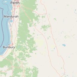
Map view of Kojonup Reserve

Use this park location map to pinpoint Kojonup Reserve in Australia, understand its exact geographic position, and read its mapped placement within the surrounding landscape more clearly.

Pigeon | © OpenStreetMap contributors

Location context for Kojonup Reserve

Western Australia
Recorded earthquake history

Explore the Historical Earthquake Record for Kojonup Reserve

Review recorded seismic activity associated with the geography of Kojonup Reserve through a curated historical database. This MoriAtlas resource allows for the examination of event patterns and proximity data without providing hazard assessments or predictive outlooks.

Kojonup Reserve Earthquake History

Catalogued events

6 events

Strongest magnitude

Magnitude 4.9

Most recent event

Feb 5, 2023

This history includes earthquakes recorded inside the park or within 50 km of its borders

Park atlas

Discover related protected landscapes and regional bushland remnants across the surrounding countryside

Explore Other Parks Near Kojonup Reserve and Protected Areas in Western Australia

Visitors exploring Kojonup Reserve can continue browsing nearby protected areas and connected remnant bushland across the surrounding region. Comparing adjacent nature reserves provides deeper geographic context for the remaining wandoo woodland communities of Western Australia.
National parkWestern Australia
70 km away#1 closest

Southwest

Greater Kingston National Park: A National Park in Western Australia's Diverse Geography

Explore mapped boundaries and regional landscape context.

Greater Kingston National Park represents a protected landscape within the vast expanse of Western Australia. As a national park, it contributes to the structured understanding of conservation areas and natural terrain across the state. This dedicated entry provides essential geographic context, allowing for detailed exploration of the park's mapped boundaries and its role within the broader regional geography of Western Australia. Discover its identity as a protected natural area.

Area
210.92 km²
Established
2004
Climate
Temperate
Scope
Terrestrial
Watercolor illustration showing a landscape with mountains, a winding river, and grassy fields.
National parkWestern Australia
77 km away#2 closest

Southeast

Stirling Range National Park: National Park Protected Area and Geographic Mapping

Discover its mapped boundaries and regional landscape context.

Stirling Range National Park is a protected national park in Western Australia, offering critical insights into regional geography and landscape mapping. This page provides structured information on the park's protected area status, its geographic setting, and its value for atlas-based exploration. Understand the extent of its mapped boundaries and discover its unique natural terrain within the broader context of Western Australia's vast geography.

Area
1,159.2 km²
Established
1913
IUCN
II
Relief
Mountain
National parkAustralia
82 km away#3 closest

West

Greater Preston National Park: Explore Old-Growth Jarrah Forest and Protected Landscape Boundaries

National Park in Western Australia's Jarrah Forest region.

Greater Preston National Park is a significant conservation area safeguarding extensive old-growth jarrah forests in Western Australia's South West region. As a national park within the Jarrah Forest bioregion, it offers a protected landscape characterized by mature woodland ecosystems. This page facilitates exploration of the park's geographic setting, its mapped boundaries, and its importance as a preserved natural environment for understanding regional forest ecology.

Area
113.73 km²
Established
2004
Climate
Mediterranean
Access
Moderate access
National parkAustralia
87 km away#4 closest

North

Dryandra Woodland National Park: Australia National Park Atlas and Protected Landscape

Explore its mapped boundaries and natural terrain.

Dryandra Woodland National Park stands as a protected area within Australia, designated as a national park. This page provides a detailed look at its geographic setting, mapped landscape features, and its role in the country's protected lands. Understand the protected boundaries and natural terrain that characterize this important conservation site, contributing to a comprehensive view of Australia's natural atlas.

Area
280.66 km²
Established
2022
Visitors
30K annual
Relief
Upland
National parkGreat Southern
92 km away#5 closest

South

Mount Roe National Park: Detailed Protected Landscape and Geographic Exploration

Mapped boundaries and natural terrain of this national park.

Mount Roe National Park offers a distinct protected landscape for atlas exploration, situated within the geographic scope of the Great Southern region. This detail page provides a structured view of the park's mapped boundaries and its natural terrain. Understand how Mount Roe National Park contributes to the regional geography and the overall map of protected areas in Australia.

Area
1,278 km²
Established
2004
IUCN
II
Scope
Terrestrial
National parkWestern Australia
97 km away#6 closest

Southwest

Lake Muir National Park: A Ramsar-Listed Wetland National Park in Western Australia

Explore mapped boundaries and the unique paperbark woodland landscapes.

Lake Muir National Park protects a significant portion of the Muir-Byenup System, a Ramsar-designated wetland complex in Western Australia's south-west. This national park serves as a vital habitat for waterbirds and features characteristic paperbark woodlands surrounding the large inland Lake Muir. Understanding its protected area status and mapped geographic features provides crucial insight into the region's ecological importance.

Area
96.36 km²
Established
2004
IUCN
II
Access
Access unknown
National parkWestern Australia
105 km away#7 closest

West

Wellington National Park: Protected Jarrah Forest & Collie River Landscape

Explore the mapped boundaries and regional geography.

Wellington National Park offers a deep dive into Western Australia's protected landscapes, characterized by extensive old-growth jarrah forests and the scenic Collie River valley. This national park provides a vital study of the region's unique geography, mapped terrain, and ecological significance within the Yilgarn craton. Understand the park's protected area identity and its place in the wider natural context of Western Australia through its detailed landscape features.

Area
170 km²
Established
2000
IUCN
II
Visitors
212K annual
National parkShire of Manjimup
106 km away#8 closest

Southwest

Boyndaminup National Park: Explore Protected Area Boundaries and Geographic Setting

An Australian national park with distinct mapped landscapes.

Boyndaminup National Park is a key protected area providing rich opportunities for geographic discovery. This atlas-focused entry details its mapped boundaries and situates it within the broader landscape context of the Shire of Manjimup. Understand the park's identity as a national park and its role in Australia's conservation network, offering specific insights for map-based exploration and regional geography.

Area
54.43 km²
Established
2004
IUCN
II
Scope
Terrestrial

Common questions about visiting, size, designation, and location context for Kojonup Reserve

Kojonup Reserve FAQs for park facts, access, geography, and protected area context

Find quick answers about Kojonup Reserve, including protected-area facts, park geography, trail and visitor context, and how the park fits into its surrounding country and regional landscape.
MoriAtlas Explorer

Continue Your Protected Areas Search Across the Global Atlas

Deepen your exploration by continuing the structured search for national parks and protected areas worldwide. Utilize the comprehensive filtering capabilities to compare different conservation landscapes and refine your understanding of global park geography. Discover more about the distribution and characteristics of protected natural areas.

Global natural geography