Peaks
Гора Скелі Словацького
410 m

Structured data on regional extent, topographic elevations and natural landscapes
Examine the geographic foundation of Kremenets Mountains National Nature Park located in the Ternopil Oblast of Ukraine. This profile covers recorded area measurements, boundary dimensions and elevation peaks up to 409 meters within the regional plateau. Explore the distribution of forest covers, karst systems and distinct mountain peaks integrated into this protected natural region.

A ridge of chalk and limestone peaks protecting endemic flora in western Ukraine's Podolian Upland
Kremenets Mountains National Nature Park is a protected area in western Ukraine that encompasses a distinctive cluster of low mountains and ridges forming the southeastern portion of the Holohory-Kremenets Ridge. The park is situated in the Kremenets and Shumsk districts of Ternopil Oblast, near the town of Kremenets. The landscape is characterized by highly eroded chalk, clay, and limestone hills rising 100 to 200 meters above the surrounding terrain, with absolute elevations ranging from 350 to 408 meters above sea level. The underlying geological structure features a foundation of white chalk up to 100 meters thick, overlain by sandstone and limestone deposits laid down by the ancient Galician Sea 15 to 20 million years ago. The park lies within the Central European mixed forests ecoregion and experiences a humid continental climate with warm summers and cold, snowy winters.
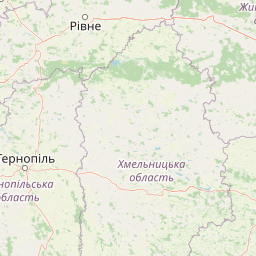
Regional positioning within Ternopil Oblast and Kremenets Raion
Interactive boundary geometry, coordinate limits, and derived area metrics
Mixed relief topography and recorded internal natural features
Peaks
410 m
Peaks
357 m
Peaks
367 m
Ponds
Peaks
397 m
Peaks
Temperate climate zone, broadleaf forests, and mixed relief topography
Mountains · Hills · Valleys · Plateau · Forest · Woodland · Grassland · Cliffs · Cave · Karst
Temperate broadleaf forest · Montane forest · Grassland · Steppe · Karst habitat
Discover connected protected landscapes and regional park geography within Ternopil Oblast, Ukraine.
Southwest

Explore unique karst features and ancient forests in Lviv Oblast.
Northern Podillia National Nature Park is a protected national park in Lviv Oblast, Ukraine, safeguarding a significant area of the Podolian Upland. The park is distinguished by its ancient beech forests, rare karst lakes known as the Blue Windows, and geological formations reflecting ancient sea reefs. This page serves as a dedicated atlas entry for understanding the park's mapped boundaries, its ecological significance, and its place within the regional geography of western Ukraine.
East
Explore its protected boundaries and landscape context.
Delve into the detailed atlas information for Derman, Ostroh National Nature Park, a designated national nature park located in Ukraine's Rivne Oblast. This resource illuminates the park's specific geographic footprint, its protected land status, and its contribution to the regional landscape. Understand its terrain and mapped features, offering a clear point of discovery for those interested in the geography of Ukrainian protected areas.
East
National Park in Ukraine's Polissia region.
The Lower Polissia National Nature Park is a crucial protected area covering 8,762 hectares in western Ukraine. This park offers a detailed geographic profile, showcasing its extensive wetland habitats, forest complexes, and the Horyn, Viliia, and Hnylyi Rih river valleys. As a key component of the Polissia landscape zone, the park provides essential context for understanding the protected natural terrain and regional ecology of Eastern Europe through structured map exploration.
North
UA National Park with Mapped Boundaries and Terrain Context
Delve into Tsumanska Pushcha National Nature Park, a designated national park in Volyn Oblast, Ukraine. This entry provides detailed atlas-style information on the park's protected landscape identity, its mapped geographic setting, and its significance within the regional geography of Northwestern Ukraine. Understand the park's boundaries and its place in the natural terrain.

Southwest

A transnational network of old growth beech forest reserves across Europe.
Examine the geographic distribution and protected boundaries of the Primeval Beech Forests of the Carpathians and Other Regions of Europe. This site highlights the continent's most intact beech forest ecosystems, illustrating essential ecological processes from the Balkans and Carpathians to the Alps and Western Europe.
Southwest
Mapped protected boundaries and landscape context.
Halych National Nature Park is a vital protected area situated in the Ivano-Frankivsk Oblast of Ukraine, characterized by its transitional landscape where Carpathian foothills merge with the East European Plain. This national park offers a rich tapestry of environments, including oak-hornbeam and oak-beech forests, vital wetlands, and scarce steppe remnants, creating a mosaic of habitats mapped meticulously within the MoriAtlas platform. Explore the park's geographic identity, its diverse terrain, and its significance as a conservation landscape for understanding regional biodiversity.
West
Mapped protected area boundaries and natural terrain context.
Yavoriv National Nature Park is a designated national park within Lviv Oblast, Ukraine. This page provides detailed geographic information, focusing on the park's protected landscape identity and its mapped terrain. Understanding its location in Western Ukraine, near the Carpathian gateway, offers valuable context for atlas-based exploration of protected areas and natural features within the region.
West

Extensive forest sanctuary in the Podkarpackie Voivodeship
Uroczyska Roztocza Wschodniego comprises vast, compact forest tracts on the Eastern Roztocze, defined by high-value woodland communities including beech and oak-hornbeam forests. The area functions as a critical protected landscape that supports diverse fauna and complex hydrological corridors within a significant regional conservation network.
Investigate the precise location and mapped boundaries of Kremenets Mountains National Nature Park to deepen your understanding of its protected status. MoriAtlas facilitates detailed exploration of its regional geography and natural terrain, connecting this national park to the wider atlas of protected areas and landscapes. Discover the unique geographic context that defines this significant Ukrainian natural site.