

Mori Atlas logo
National parkKroombit Tops National Park

Discover the mapped boundaries and regional natural terrain of this Queensland national park.

Kroombit Tops National Park: Protected Landscape Atlas and Geographic Context

Kroombit Tops National Park stands as a key protected area within Queensland, Australia, offering valuable insights for geographic discovery. This page serves as an entry point to understanding the park's specific protected landscape identity, its distribution within the state's geography, and its mapped natural terrain. Explore how Kroombit Tops National Park contributes to the broader atlas of Australian conservation lands, providing a detailed view of its boundaries and regional landscape context.

National ParkQueenslandEndemic SpeciesWWII HistoryBiodiversity HotspotRainforest

Kroombit Tops National Park

National park

Park overview

Structured park overview, official facts, and landscape profile for Kroombit Tops National Park

Kroombit Tops National Park park facts, protected area profile, and essential visitor context
Review the core facts for Kroombit Tops National Park, including designation, size, terrain, visitor scale, habitats, and operating context in one park-focused overview.

About Kroombit Tops National Park

Kroombit Tops National Park occupies a significant position in Queensland's protected area network, representing the biodiversity of the Central Queensland region. The park's terrain encompasses varied landscapes that support complex ecosystems, from wetter forested areas to more open woodland sections. Its establishment in 1974 reflected growing recognition of the area's ecological importance, particularly its role as a refuge for specialized species adapted to particular habitat conditions within this part of Australia. The park's location between Monto and Calliope places it within a broader context of rural and semi-natural landscapes, with Cania Gorge National Park situated approximately 25 kilometers to the south. Management by the Queensland Parks and Wildlife Service ensures ongoing protection of the park's natural and historical values while providing opportunities for sustainable visitor enjoyment. The combination of irreplaceable biodiversity and WWII heritage makes Kroombit Tops distinctive among Queensland's national parks.

Quick facts and research context for Kroombit Tops National Park

Kroombit Tops National Park spans 74.6 square kilometers in Central Queensland, established in 1974. The park protects unique Australian ecosystems and is the sole known habitat for the critically endangered Kroombit tinker frog and the recently described silver-headed antechinus. In February 1945, a Consolidated B-24D Liberator bomber nicknamed 'Beautiful Betsy' crashed in the park during a flight from Darwin to Brisbane; the wreckage was discovered in 1994 and the site now features a commemorative plaque. The park offers recreational activities including birdwatching, bushwalking, off-road driving, and camping at Griffiths Creek Campground.

Park context

Deeper park guide and search-rich context for Kroombit Tops National Park

Kroombit Tops National Park history, landscape, wildlife, and travel context
Explore Kroombit Tops National Park through its history, landscape character, ecosystems, wildlife, conservation priorities, cultural context, and seasonal travel timing in a structured park guide built for atlas discovery and search intent.

Why Kroombit Tops National Park stands out

Kroombit Tops is best known for its remarkable endemism, supporting species found nowhere else on the planet. The park is the only known habitat of the critically endangered Kroombit tinker frog, with fewer than 200 individuals remaining in the wild as of 2020, and the silver-headed antechinus, a marsupial species only described in 2013. The WWII bomber crash site of 'Beautiful Betsy' adds a distinctive historical dimension rarely found in Australian national parks. The park also supports the rare Kroombit Tops Assassin Spider and a small population of wild brumbies.

Kroombit Tops National Park history and protected-area timeline

The establishment of Kroombit Tops National Park in 1974 marked the formal recognition of the area's ecological significance after decades of land use and exploration. However, the park's history extends far deeper into Australia's past, with the most dramatic chapter written during World War II. On February 26, 1945, during stormy weather, a United States Army Air Forces Consolidated B-24D Liberator bomber named 'Beautiful Betsy' disappeared while on a 'Fat Cat' supply run from Darwin to Brisbane, carrying men and supplies as part of regular military air operations. The aircraft was transporting six American aviators and two British Royal Air Force Spitfire pilots. The wreckage was finally discovered on August 2, 1994, resting within what was then the national park. The crash site has been preserved with a commemorative plaque, providing a sobering reminder of the human cost of wartime operations and adding a unique historical layer to the park's identity. This discovery brought international attention to the park and connected its conservation mission with a meaningful human story.

Kroombit Tops National Park landscape and geographic character

Kroombit Tops National Park encompasses diverse terrain characteristic of the Central Queensland highlands region. The park's landscape features a mixture of ridgelines, valleys, and forested areas that create varied visual and ecological character across its 74.6 square kilometer extent. The larger eastern portion spans multiple localities including Tablelands, Valentine Plains, Cania, and Boyne Valley, while the smaller western section occupies the Mount Alma area. Vegetation communities range from denser rainforest patches in sheltered gullies to more open woodland on exposed slopes and ridges. The terrain supports numerous creeks and drainage lines that provide moisture to the forest ecosystems, particularly important for the moisture-dependent species that inhabit the park. This topographic and vegetational diversity contributes to the park's biological significance by creating multiple habitat types within a relatively compact area.

Kroombit Tops National Park ecosystems, habitats, and plant life

The ecological significance of Kroombit Tops National Park centers on its role as a sanctuary for species with extremely restricted distributions. The park's habitats support several organisms that have evolved in isolation within this specific region of Queensland, resulting in levels of endemism rarely encountered in other protected areas. The moist forest environments provide critical habitat for the Kroombit tinker frog, a species completely dependent on the park's particular conditions and now facing severe risk of extinction. Similarly, the recently described silver-headed antechinus represents a mammalian species known only from this protected area, demonstrating the park's importance for conservation science. The vegetation communities themselves display patterns typical of Central Queensland's subtropical forests, with species compositions that differ from both tropical rainforests to the north and more temperate forests to the south. This transitional ecological character contributes to the park's scientific and conservation value.

Kroombit Tops National Park wildlife and species highlights

Kroombit Tops National Park harbors an extraordinary concentration of rare and endemic wildlife, making it one of Queensland's most significant protected areas for biodiversity conservation. The Kroombit tinker frog represents the park's most endangered resident, with population estimates so low that the species teeters on the edge of extinction; successful captive breeding efforts at Currumbin Wildlife Sanctuary in 2020 offered crucial hope for the species' survival. The silver-headed antechinus, a small carnivorous marsupial described scientifically in 2013, remains known only from this park, highlighting its global conservation responsibility. The Kroombit Tops Assassin Spider (Austrarchaea alani) is another species found exclusively within the park's boundaries, demonstrating the area's exceptional evolutionary isolation. Birdwatchers find the park rewarding due to diverse avian communities, while the presence of wild brumbies adds an element of Australian pastoral history to the park's wildlife mix. These species collectively underscore why Kroombit Tops is considered essential for protecting Queensland's unique terrestrial biodiversity.

Kroombit Tops National Park conservation status and protection priorities

Kroombit Tops National Park serves as a critical conservation refuge for several species facing imminent extinction risk outside its boundaries. The park's designation as an IUCN Category II protected area reflects its primary purpose of preserving natural ecosystems while allowing for compatible recreational use. The Kroombit tinker frog's precarious status, with fewer than 200 individuals remaining entirely within the park's rainforests, represents one of Australia's most urgent amphibian conservation priorities. Collaborative efforts between Queensland Parks and Wildlife Service and organizations like Currumbin Wildlife Sanctuary have enabled captive breeding programs that may eventually support reintroduction efforts. The discovery and protection of the silver-headed antechinus demonstrates how national parks serve as frontiers for biological discovery, with new species still being identified within their boundaries. The park's WWII heritage site also receives conservation attention, balancing natural and cultural preservation objectives.

Kroombit Tops National Park cultural meaning and human context

While Kroombit Tops National Park is primarily valued for its natural and historical significance, it exists within a broader landscape of rural Queensland where agricultural activity and mining have shaped the surrounding region. The presence of wild brumbies connects the park to Australia's pastoral heritage, as these descendants of escaped or released horses have roamed the area for generations. The WWII bomber crash represents a moment when international events intersected with this remote Australian landscape, bringing eight service personnel to their deaths far from their homelands. The park's proximity to towns like Monto and Calliope reflects its role in the regional identity of Central Queensland, where protected areas provide both ecological services and sense of place. Indigenous heritage context specific to the Kroombit Tops area is not extensively documented in available sources, though the broader Central Queensland region contains significant Aboriginal cultural connections to the landscape.

Top sights and standout views in Kroombit Tops National Park

Kroombit Tops National Park stands out among Queensland's protected areas through its combination of irreplaceable biodiversity and World War II heritage. The park's global significance is defined by species found nowhere else: the critically endangered Kroombit tinker frog, the recently discovered silver-headed antechinus, and the specialized Kroombit Tops Assassin Spider. Visitors can explore the preserved crash site of the 'Beautiful Betsy' B-24 Liberator, a somber historical marker unique among Australian national parks. The park's compact 74.6 square kilometer extent contains remarkable ecological diversity, from rainforest pockets to woodland environments, supporting exceptional endemism. Recreational opportunities including birdwatching, bushwalking, and camping at Griffiths Creek Campground make the park accessible for visitors while conservation efforts work to secure the future of its most vulnerable residents.

Best time to visit Kroombit Tops National Park

The optimal time to explore Kroombit Tops National Park depends on what visitors hope to experience, with Queensland's subtropical climate offering different conditions throughout the year. The cooler winter months from May through September typically provide more comfortable conditions for bushwalking and outdoor activities, with reduced humidity and milder daytime temperatures. Summer months from December to February bring warmer conditions and higher rainfall, which can affect track conditions and accessibility but may also increase wildlife activity in the park's moist environments. The park can be visited year-round, though visitors should check current conditions and any park closures before traveling, particularly during the wet season when some roads may become impassable. Birdwatching opportunities exist throughout the year, with different species more active during different seasons.
Park location guide

Geography guide, regional context, and park location map for Kroombit Tops National Park

Kroombit Tops National Park park geography, regions, and map view in Australia
Understand where Kroombit Tops National Park sits in Australia through a broader geographic reading of the surrounding landscape, nearby location context, and its mapped position within the national park landscape.

How Kroombit Tops National Park fits into Australia

Australia is a constitutional monarchy and federal parliamentary democracy comprising six states and ten territories. With a population of nearly 28 million, it is one of the world's most urbanised countries, with most people concentrated on the eastern seaboard. The country has a high Human Development Index and is known for its cultural diversity, ancient Aboriginal heritage, and unique wildlife.

Wider geography shaping Kroombit Tops National Park in Australia

Australia occupies the entire Australian continent, the island of Tasmania, and numerous smaller islands. It is the world's flattest and driest inhabited continent, featuring vast deserts in the interior (the Outback), tropical rainforests along the eastern coast, and a coastline bordering the Indian and Pacific Oceans.

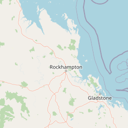
Map view of Kroombit Tops National Park

Use this park location map to pinpoint Kroombit Tops National Park in Australia, understand its exact geographic position, and read its mapped placement within the surrounding landscape more clearly.

Pigeon | © OpenStreetMap contributors

Location context for Kroombit Tops National Park

Queensland
Park atlas

Trace the Regional Spread of Protected Landscapes and Compare Parks Near Kroombit Tops National Park, Central Queensland

Explore Nearby Protected Areas and National Parks Surrounding Kroombit Tops National Park
Browse a curated selection of national parks and protected areas located geographically near Kroombit Tops National Park in Central Queensland, Australia. Compare diverse protected landscapes, conservation efforts, and unique features across the surrounding region, offering a deeper atlas view beyond a single park.
National parkQueensland

Cania Gorge National Park: A Distinct Queensland National Park with Dramatic Sandstone Cliff Formations

Explore mapped gorge terrain, rock art sites, and diverse Queensland landscapes.

Cania Gorge National Park represents a significant protected area within Queensland, Australia, distinguished by its dramatic 70-meter sandstone cliffs and the ancient Aboriginal rock art found within its caves. The park's rugged gorge terrain, shaped by Three Moon Creek, offers a unique geographic context and landscape to explore. Its mapped boundaries encompass diverse ecological communities and geological features, making it a focal point for understanding regional park identity and natural heritage within Queensland's broader atlas.

Area
30 km²
Established
1977
IUCN
II
Relief
Upland
National parkQueensland

Castle Tower National Park: Queensland National Park with Granite Peaks and Woodland

Mapped terrain and protected landscape in the Gladstone Region.

Castle Tower National Park in Queensland represents a significant protected natural area characterized by striking granite peak formations and expansive eucalypt woodlands. Established in 1932, the park's rugged terrain, including Mount Stanley, offers a unique geographic perspective within Central Queensland. This national park provides an opportunity to explore its mapped boundaries and distinctive landscape context, distinguishing it as a notable protected area in the Gladstone Region.

Area
49.8 km²
Established
1932
IUCN
II
Relief
Mountain
National parkQueensland

Bulburin National Park: Central Queensland's Significant Subtropical Rainforest Preserve

Mapped protected landscape and ecological refuge.

Bulburin National Park represents the most substantial remaining area of subtropical rainforest in central Queensland, established as a protected national park. Its dense forest ecosystem provides crucial habitat for numerous species, including endangered marsupials and notable birdlife. Exploring Bulburin National Park reveals a distinct natural landscape within Queensland, offering insights into regional conservation and the geographic distribution of vital protected areas.

Established
2015
IUCN
II
Relief
Lowland
Climate
Subtropical
National parkQueensland

Mount Colosseum National Park: Queensland's Premier Protected Landscape Discovery

Mapped natural terrain and regional geographic context.

Mount Colosseum National Park offers a detailed view into Australia's protected natural areas, specifically within the state of Queensland. This entry focuses on its identity as a national park, providing essential context for its mapped boundaries, surrounding regional geography, and the unique character of its natural landscape. It serves as a key reference for understanding the park's protected status and geographic significance.

Area
8.4 km²
Established
1977
IUCN
II
Relief
Mountain
National parkQueensland

Wild Cattle Island National Park: Queensland National Park and Protected Landscape Discovery

Mapped boundaries and regional geographic context for exploration.

Wild Cattle Island National Park, situated in Queensland, Australia, is identified as a national park focused on preserving its natural landscape. This page provides a detailed view of its protected area status and geographic placement within the broader Australian context. Users can explore the park's specific mapped boundaries and its relation to Queensland's diverse terrain, supporting structured discovery for those interested in protected lands and their regional atlas representation.

Area
5.8 km²
Established
1992
IUCN
II
Relief
Lowland
National parkQueensland

Warro National Park National Park: Queensland's Protected Landscape Geography

Explore mapped boundaries and regional context within Queensland.

Warro National Park stands as a significant protected area within Queensland, Australia, recognized for its national park status. This page provides a detailed view of its geographic identity, helping users understand its placement within the broader atlas of protected lands. Examine the park's role as a mapped landscape feature and its contribution to Queensland's regional geography, essential for any structured exploration of Australia's natural areas.

Area
60.32 km²
Established
2006
IUCN
II
Relief
Upland
National parkQueensland

Rundle Range National Park: Queensland's National Park Protected Landscape Exploration

Explore its mapped boundaries and regional geographic context.

Delve into the protected landscape of Rundle Range National Park, a designated national park situated within Queensland, Australia. This entry provides focused insights into its geographic setting, mapped park boundaries, and its significance as a protected area. It is designed to aid in understanding the park's specific natural context and its place within the broader Queensland regional geography for detailed atlas discovery.

Area
21.7 km²
Established
1993
IUCN
II
Scope
Terrestrial
Watercolor illustration showing green trees and distant hills under a pastel sky
National parkQueensland

Eurimbula National Park: Central Queensland's Diverse Coastal Protected Landscape

Explore mapped terrain and protected ecosystem boundaries.

Eurimbula National Park in Queensland is an exceptional example of a protected coastal wilderness, featuring a remarkable array of habitats including mangroves, littoral rainforests, and extensive paperbark wetlands. Its diverse landscape supports significant biodiversity and offers a clear representation of central Queensland's natural heritage. Understanding Eurimbula National Park's geography through its mapped protected area helps situate its ecological importance within the broader Australian atlas.

Area
125 km²
Established
1977
IUCN
II
Relief
Lowland

Common questions about visiting, size, designation, and location context for Kroombit Tops National Park

Kroombit Tops National Park FAQs for park facts, access, geography, and protected area context
Find quick answers about Kroombit Tops National Park, including protected-area facts, park geography, trail and visitor context, and how the park fits into its surrounding country and regional landscape.
MoriAtlas Explorer

Continue Your Protected Areas Search Across the Global Atlas

Deepen your exploration by continuing the structured search for national parks and protected areas worldwide. Utilize the comprehensive filtering capabilities to compare different conservation landscapes and refine your understanding of global park geography. Discover more about the distribution and characteristics of protected natural areas.

Global natural geography
