

Mori Atlas logo
National parkKui Buri National Park

Discover the mapped boundaries and mountainous terrain of this critical wildlife corridor.

Kui Buri National Park: Protected Landscape and Elephant Habitat in Prachuap Khiri Khan

Kui Buri National Park represents a significant protected landscape within Thailand, designated as the country's 90th national park and recognized as a UNESCO World Heritage Site. Encompassing approximately 969 square kilometers of mountainous terrain in Prachuap Khiri Khan Province, its forested hills and valleys form a crucial wildlife corridor. This atlas-focused entry provides detailed geographic context, helping you understand the park's mapped boundaries and its role in supporting remarkable biodiversity.

National parkForest reserveElephant habitatUNESCO World Heritage SiteTenasserim HillsWildlife corridor

Kui Buri National Park

National park

Park overview

Structured park overview, official facts, and landscape profile for Kui Buri National Park

Kui Buri National Park park facts, protected area profile, and essential visitor context

Review the core facts for Kui Buri National Park, including designation, size, terrain, visitor scale, habitats, and operating context in one park-focused overview.

About Kui Buri National Park

Kui Buri National Park occupies a significant geographic position in the Tenasserim Hills, a mountain range that extends along the Thai-Malay border and connects to broader Indochinese ecosystems. The park's establishment in 1999 marked an important expansion of Thailand's protected area network, creating a contiguous forest corridor that links with Kaeng Krachan National Park to the north. The reserve encompasses diverse topography including steep hills, valleys, and forest-covered slopes that drain into local watershed systems. Prachuap Khiri Khan Province on the Gulf of Thailand coast provides the park's regional context, with the protected area serving as an ecological anchor for the province's western mountainous interior. The park's inclusion in the Kaeng Krachan Forest Complex in 2021 as a UNESCO World Heritage Site reflects international recognition of its outstanding universal value as a tropical forest ecosystem.

Quick facts and research context for Kui Buri National Park

Kui Buri National Park covers 969 km² in Prachuap Khiri Khan Province, Thailand, in the Tenasserim Hills. Established in 1999, it is the 90th national park of Thailand and part of the Kaeng Krachan Forest Complex, designated a UNESCO World Heritage Site in 2021. The park features dry evergreen and moist evergreen forests and receives approximately 20,746 visitors annually. It holds the unique distinction of being the only source of sandalwood in Thailand approved for royal cremation ceremonies.

Protection and recognition

Documenting terrestrial boundaries and official global conservation designations

Kui Buri National Park Protection Status and UNESCO Recognition Details

Kui Buri National Park holds terrestrial protection status and is recognized as part of the Kaeng Krachan Forest Complex UNESCO World Heritage site. Analyzing established conservation boundaries and global designations helps clarify the structured management framework governing the regional forest landscape.

International recognition

Protection details

Protection scope
Terrestrial
Transboundary protection
No
Park context

Deeper park guide and search-rich context for Kui Buri National Park

Kui Buri National Park history, landscape, wildlife, and travel context

Explore Kui Buri National Park through its history, landscape character, ecosystems, wildlife, conservation priorities, cultural context, and seasonal travel timing in a structured park guide built for atlas discovery and search intent.

Why Kui Buri National Park stands out

Kui Buri National Park is best known for its significant population of Asian elephants and other large mammals including gaur, tigers, and leopards. The park contains the only harvestable sandalwood resource in Thailand, reserved exclusively for royal cremation purposes, with trees over 100 years old selected by royal Brahmins for this sacred purpose. Its position within the Tenasserim Hills makes it a critical wildlife corridor, while the dry and moist evergreen forest ecosystem supports remarkable biodiversity in central Thailand.
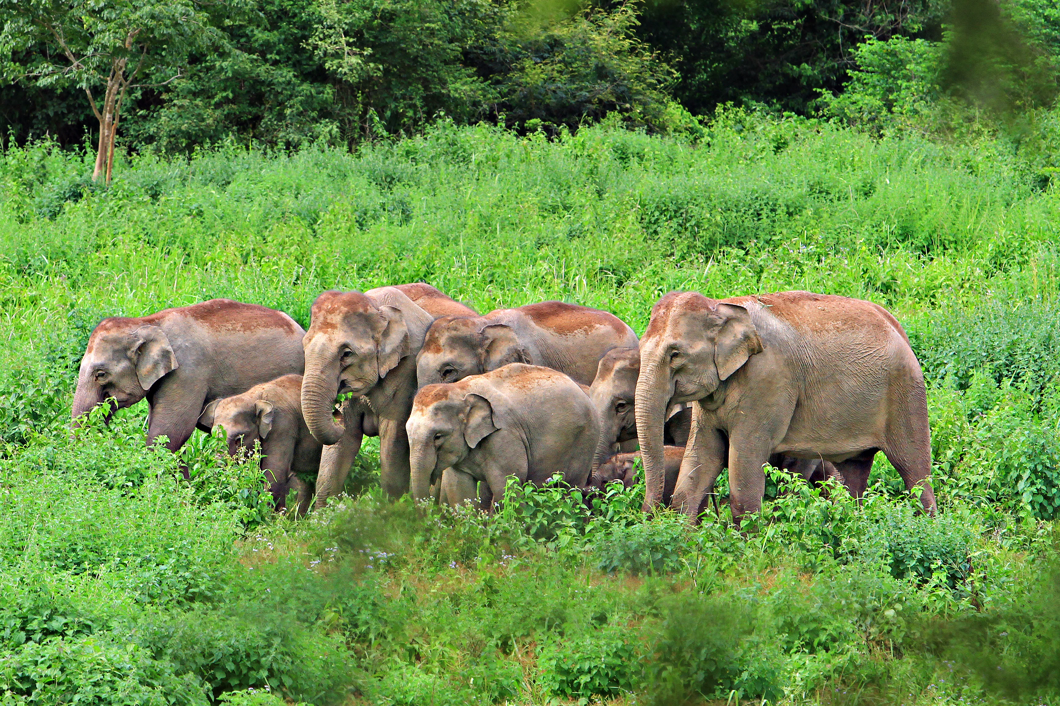
A group of wild elephants including adults and calves standing in dense green vegetation
Elephants grazing in the lush greenery of Kui Buri National Park

Kui Buri National Park history and protected-area timeline

Kui Buri National Park was established in March 1999 as the 90th national park in Thailand's system of protected areas, administered by the Department of National Parks, Wildlife and Plant Conservation. The park was created to protect the forest ecosystems of the Tenasserim Hills region and the wildlife populations they support, particularly large mammals including Asian elephants and tigers. The selection of the area for national park status reflected growing awareness of the ecological importance of the Tenasserim corridor and the need to connect fragmented protected lands across the Thai-Malay peninsula. The park's subsequent designation as part of the Kaeng Krachan Forest Complex World Heritage Site in 2021 represented the culmination of decades of conservation efforts in the region.

Kui Buri National Park landscape and geographic character

The landscape of Kui Buri National Park is defined by the forested slopes and ridges of the Tenasserim Hills, a range that forms part of the greater mountain system extending through mainland Southeast Asia. The terrain consists of rolling to steep hillsides covered in evergreen forest, with elevation changes creating diverse microhabitats throughout the reserve. The forest cover transitions between dry evergreen and moist evergreen types depending on aspect and elevation, with the vegetation forming a contiguous green mantle across the mountainous terrain. The park's location in Prachuap Khiri Khan Province places it within a broader landscape of coastal plains to the east and additional protected areas to the north and west.

Kui Buri National Park ecosystems, habitats, and plant life

The forests of Kui Buri National Park are characterized by dry evergreen and moist evergreen forest types typical of the Tenasserim region. Key tree species include Dipterocarpus tuberculatus, Hopea odorata, and Terminalia chebula, along with various palm species. The park holds exceptional significance for sandalwood (Santalum), with more than 200,000 trees documented within the reserve. This sandalwood population represents the only source in Thailand approved for harvesting for royal cremation ceremonies, a tradition that requires trees to be dead and over 100 years old. Nine trees from the park were selected for the royal cremation of King Bhumibol Adulyadej, demonstrating the park's unique cultural and ecological role.

Kui Buri National Park wildlife and species highlights

Kui Buri National Park supports a notable assemblage of large mammals characteristic of mainland Southeast Asian forests. Asian elephants move through the park in significant numbers, while gaur, the largest wild cattle species in the region, inhabit the forest clearings and slopes. Predators present include tigers and leopards, both of which rely on the park's forest corridors for movement and hunting. The park also supports Malayan tapir, a distinctive species recognizable by its black and white markings, along with serow, a mountain-dwelling goat-antelope. Primates including gibbons, macaques, and langurs are found throughout the canopy, while deer species such as sambar deer and barking deer occupy forest understories. Smaller mammals include Fea's muntjac, lesser mouse deer, wild pig, and Asiatic black bear. This diversity positions the park as an important conservation area for Thailand's forest-dependent fauna.

Kui Buri National Park conservation status and protection priorities

Kui Buri National Park serves as a critical component of the Kaeng Krachan Forest Complex, recognized in 2021 as a UNESCO World Heritage Site of outstanding universal value. The park's role in connecting fragmented forest habitats along the Tenasserim corridor makes it essential for maintaining ecological processes across the Thai-Malay peninsula. The protection of Asian elephant populations is particularly significant, as these animals require large contiguous territories and face increasing pressure from habitat fragmentation throughout their range. The sandalwood resource represents both a conservation challenge and a unique cultural asset, with the park's status as the sole source for royal cremation ceremonies creating strong incentives for protection of these ancient trees.

Kui Buri National Park cultural meaning and human context

The cultural significance of Kui Buri National Park extends beyond its ecological value through its role in Thailand's royal traditions. The sandalwood trees within the park are the only ones in Thailand permitted for use in royal cremation ceremonies, a practice requiring selection by royal Brahmins who spend months identifying trees meeting specific criteria. Nine trees from Kui Buri were harvested for the cremation of King Bhumibol Adulyadej, Thailand's long-reigning monarch. This royal connection provides the park with a unique cultural identity and reinforces the importance of protecting these ancient trees for future generations.

Top sights and standout views in Kui Buri National Park

Kui Buri National Park stands out as a critical elephant habitat within Thailand's protected area network, supporting viable populations of these endangered megaherbivores alongside tigers and leopards. The park's UNESCO World Heritage Site status reflects its importance as a biodiversity corridor in the Tenasserim region. The ancient sandalwood forest, reserved exclusively for royal ceremonial use, represents a living link between Thailand's natural heritage and monarchical traditions. The combination of dry and moist evergreen forests creates a visually diverse landscape that supports the country's largest national park complex designation.

Best time to visit Kui Buri National Park

Kui Buri National Park can be visited throughout the year, though the cool dry season from November to February typically offers the most comfortable conditions for exploration. The forest environment remains lush during the wet season from May to October, when rainfall contributes to the evergreen character of the park's vegetation. Wildlife viewing opportunities exist year-round, though dry conditions may concentrate animals more visibly around water sources during the hotter months from March to April.
Monthly climate preview

Long term monthly temperature and precipitation rhythm at a representative coordinate

Kui Buri National Park Climate Normals and Measured Temperature Patterns

Representative coordinate data reveals annual temperature fluctuations between twenty three and twenty eight degrees Celsius alongside monthly precipitation variations. Examining the complete twelve month climate profile provides deeper context on long term meteorological normals across the terrain.
Annual mean26 °C
23 °C28 °C
Jan24°
Feb25°
Mar27°
Apr28°
May27°
Jun26°
Jul25°
Aug25°
Sep25°
Oct25°
Nov24°
Dec23°
Warmest month
April

28.2 °C

Coolest month
December

23.3 °C

Wettest month
October

8.7 mm/day

Driest month
February

0.8 mm/day

Park location guide

Geography guide, regional context, and park location map for Kui Buri National Park

Kui Buri National Park park geography, regions, and map view in Thailand

Understand where Kui Buri National Park sits in Thailand through a broader geographic reading of the surrounding landscape, nearby location context, and its mapped position within the national park landscape.

How Kui Buri National Park fits into Thailand

Thailand is a Southeast Asian nation formerly called Siam, located in mainland Southeast Asia. It operates as a unitary parliamentary constitutional monarchy under King Vajiralongkorn. The country borders Myanmar, Laos, Cambodia, and Malaysia, with maritime boundaries involving Vietnam, Indonesia, and India. Thailand has a population of nearly 66 million and covers approximately 513,120 km². Historically, the Sukhothai Kingdom marks the beginning of Thai history, followed by the powerful Ayutthaya Kingdom.

Wider geography shaping Kui Buri National Park in Thailand

Thailand occupies mainland Southeast Asia with borders to Myanmar (west/northwest), Laos (east/northeast), Cambodia (southeast), and Malaysia (south). The country has coastline along the Gulf of Thailand to the southeast and the Andaman Sea to the southwest. The territory covers approximately 513,120 km².

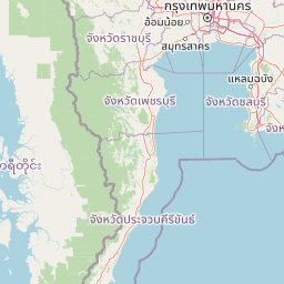
Map view of Kui Buri National Park

Use this park location map to pinpoint Kui Buri National Park in Thailand, understand its exact geographic position, and read its mapped placement within the surrounding landscape more clearly.

Pigeon | © OpenStreetMap contributors

Location context for Kui Buri National Park

Prachuap Khiri Khan Province
Recorded earthquake history

Explore the Historical Earthquake and Seismic Record for Kui Buri National Park

Consult the MoriAtlas catalogue to review historical earthquake events mapped in proximity to Kui Buri National Park. Examine documented seismic data, including magnitude and location metrics, to understand the seismic history characterizing this protected area in Thailand.

Kui Buri National Park Earthquake History

Catalogued events

6 events

Strongest magnitude

Magnitude 4.7

Most recent event

Sep 28, 2006

This history includes earthquakes recorded inside the park or within 50 km of its borders

Discover the diverse scenery, crucial forest habitats, and protected-area character of this UNESCO World Heritage Site through detailed imagery.

Explore Kui Buri National Park Photos: Visualizing Thailand's Elephant Habitats and Tenasserim Hill Landscapes

Visually explore the lush, mountainous terrain and dense evergreen forests of Kui Buri National Park, a critical wildlife corridor and elephant habitat in Thailand's Tenasserim Hills. Examining these images provides essential insights into the park's diverse protected-area environment, showcasing its unique landscape character, key ecosystems, and conservation significance.

A group of wild elephants including adults and calves standing in dense green vegetation

Park atlas

Trace the regional spread of protected landscapes, comparing adjacent wildlife corridors and conservation areas in Thailand.

Discover Nearby National Parks and Protected Areas Around Kui Buri National Park

Explore national parks and protected areas located in the wider region surrounding Kui Buri National Park, including vital parts of the Tenasserim Hills and interconnected wildlife corridors. Compare their distinct landscapes and conservation roles to understand the broader ecological network and geographic context of protected areas in central Thailand.
National parkPhetchaburi Province
6.2 km away#1 closest

North

Kaeng Krachan National Park: Thailand National Park Atlas and Protected Landscape

Mapped boundaries and regional geography of this national park.

Access detailed geographic information for Kaeng Krachan National Park, a protected national park located in Phetchaburi Province, Thailand. Understand its specific landscape context and explore its mapped boundaries within the regional geography. This resource is designed for structured atlas-driven discovery of protected natural areas.

Area
2,915 km²
Established
1981
IUCN
II
Visitors
103.5K annual
National parkPrachuap Khiri Khan Province
11 km away#2 closest

South

Hat Wanakon National Park: Mapped Protected Area within Prachuap Khiri Khan's Geography

Explore protected national park boundaries and regional landscape context.

Hat Wanakon National Park serves as a significant protected landscape entity within the Prachuap Khiri Khan Province region of Thailand. This national park's mapped boundaries offer insight into its territorial extent and its role within the country's network of conservation areas. Exploring this park provides a concrete example of protected land within the varied geography of the Kra Isthmus, enriching your atlas-based understanding of Thailand's natural reserves.

Area
38 km²
Established
1992
IUCN
II
Visitors
43.3K annual
National parkPrachuap Khiri Khan Province
About 18 km away#3 closest

South

Namtok Huai Yang National Park: Protected Mountain Terrain and Waterfall Atlas

Discover Prachuap Khiri Khan Province's significant natural landscape.

Namtok Huai Yang National Park is a key protected area in Thailand's Prachuap Khiri Khan Province, renowned for its distinctive montane geography shaped by the Tenasserim Hills. This national park offers a detailed view of forest ecosystems, watershed importance, and cascading waterfalls, all presented within a structured atlas framework. Users can explore the park's mapped boundaries and terrain characteristics, gaining a concrete understanding of its geographic significance and natural protected landscape.

Area
161 km²
Established
1991
IUCN
II
Visitors
26.9K annual
National parkPrachuap Khiri Khan Province
About 19 km away#4 closest

East

Khao Sam Roi Yot National Park: A National Park within Prachuap Khiri Khan Province's Geography

Explore the mapped protected landscape and regional context.

Investigate Khao Sam Roi Yot National Park as a distinct protected area and national park entity within the geographic framework of Prachuap Khiri Khan Province. This dedicated page offers insights into its mapped boundaries, regional landscape character, and its contribution to the atlas of protected lands in western Thailand. Understand the park's environmental geography and its specific place within the broader national conservation efforts.

Area
98 km²
Established
1966
IUCN
II
Visitors
164.7K annual
National parkPrachuap Khiri Khan Province
About 65 km away#5 closest

South

Ao Siam National Park: Protected Landscape and Regional Geography within Thailand

Discover the mapped boundaries and natural terrain of this Thai national park.

Ao Siam National Park is a designated national park in Thailand, located within the Prachuap Khiri Khan Province. This protected landscape offers valuable insights into the regional geography of the Kra Isthmus. Users can explore its mapped boundaries and understand its significance as a natural area within the atlas of Thai protected lands. The park's setting provides a concrete example of protected territory contributing to the region's overall geographic context.

Area
31.94 km²
IUCN
II
Relief
Lowland
Climate
Subtropical
National parkRatchaburi Province
About 109 km away#6 closest

North

Chaloem Phrakiat Thai Prachan National Park: Protected Landscape Identity and Geographic Atlas Context

Mapped park boundaries and regional natural terrain discovery.

Chaloem Phrakiat Thai Prachan National Park serves as a key national park entity for structured geographic discovery. This page focuses on its protected landscape, mapped boundaries, and integration within the natural geography of Ratchaburi Province. Explore the park's specific atlas contribution and its place within regional conservation land patterns, providing a factual foundation for landscape context.

Area
328.05 km²
Established
2012
IUCN
II
Climate
Tropical
National parkChumphon Province
About 176 km away#7 closest

South

Mu Ko Chumphon National Park: Mapped Archipelago and Marine Protected Landscape

Explore island geography and tropical rainforests in Chumphon Province.

Mu Ko Chumphon National Park offers a deep dive into an island archipelago landscape located in Chumphon Province. This protected area is characterized by numerous islands featuring tropical rainforests atop hilly terrain that slopes down to white-sand beaches and clear gulf waters. Examine the mapped extent of its protected marine environment and the diverse ecosystems supporting coral reefs and unique swiftlet nesting sites, providing a rich geographic context for atlas exploration.

Area
317 km²
Established
1999
IUCN
II
Relief
Mixed relief
Watercolor painting showing green hills, purple mountains, and a calm water body with sparse vegetation
National parkRayong Province
About 177 km away#8 closest

East

Khao Laem Ya, Mu Ko Samet National Park: Marine National Park and Protected Island Geography

Coastal terrain and archipelago mapped within Rayong Province.

Delve into Khao Laem Ya, Mu Ko Samet National Park, a significant marine protected area located in Rayong Province, Thailand. This atlas entry highlights the park's archipelago of islands, including Ko Samet, its mainland coastal features like Khao Laem Ya, and the surrounding Gulf of Thailand waters. Understand the park's role in coastal conservation, its mapped marine environments, and its unique blend of terrestrial and aquatic protected landscapes for geographic discovery.

Area
131 km²
Established
1981
IUCN
II
Visitors
1.6M annual

Common questions about visiting, size, designation, and location context for Kui Buri National Park

Kui Buri National Park FAQs for park facts, access, geography, and protected area context

Find quick answers about Kui Buri National Park, including protected-area facts, park geography, trail and visitor context, and how the park fits into its surrounding country and regional landscape.
MoriAtlas Explorer

Continue Your Protected Areas Search Across the Global Atlas

Deepen your exploration by continuing the structured search for national parks and protected areas worldwide. Utilize the comprehensive filtering capabilities to compare different conservation landscapes and refine your understanding of global park geography. Discover more about the distribution and characteristics of protected natural areas.

Global natural geography