Mori Atlas logo
National parkKutai National Park

Discover the protected landscape and regional geography of this Indonesian national park.

Kutai National Park: Protected Area Map and Geographic Context in East Kalimantan

Kutai National Park is a significant protected area situated in East Kalimantan, Indonesia. This page provides detailed atlas-style information, focusing on its mapped boundaries and the surrounding natural landscape. Understanding Kutai National Park's place within regional geography aids in appreciating its conservation significance and its role in a broader geographic context. Explore the unique aspects of this protected land through its mapped features and inherent landscape identity.

lowland rainforestorangutan habitatBorneo conservationdipterocarp foresttropical national parkEast Kalimantan

Kutai National Park

National park

Park overview

Structured park overview, official facts, and landscape profile for Kutai National Park

Kutai National Park park facts, protected area profile, and essential visitor context
Review the core facts for Kutai National Park, including designation, size, terrain, visitor scale, habitats, and operating context in one park-focused overview.

About Kutai National Park

Kutai National Park represents one of the last significant tracts of lowland tropical rainforest remaining on the east coast of Borneo, serving as a critical ecological corridor and habitat for numerous endangered species. The park's location just north of the equator places it within one of the most biodiverse regions on Earth, where the combination of equatorial climate and extensive river systems has produced a complex mosaic of forest types and ecological communities. The park's establishment in 1982 came as a response to escalating deforestation pressures that had already severely impacted the region's forest cover, though the intervening decades have seen continued challenges from logging, mining expansion, and agricultural encroachment. Despite these pressures, the park retains substantial areas of primary forest, particularly in the more remote western sections accessible via the Prevab entry point. The park's proximity to major population centers in East Kalimantan presents both conservation challenges and opportunities for environmental education and sustainable tourism development. The traditional Bugis communities who have inhabited the region for generations maintain a presence within the park boundaries, representing the intersection of human settlement and environmental protection that characterizes much of Indonesia's protected area management.

Quick facts and research context for Kutai National Park

Kutai National Park covers 1,986 square kilometers of lowland tropical rainforest on the east coast of Borneo in East Kalimantan province, Indonesia. The park was established in 1982 and holds IUCN Category II protected area status. It is located north of the Mahakam River, with nearby cities including Bontang and Sangatta. The park contains multiple lake systems and diverse forest types including dipterocarp lowland forest, mangrove, freshwater swamp forest, and kerangas forest. The park is home to 958 species of flora including 8 of the world's 9 genera of Dipterocarpaceae, while its fauna includes 10 primate species, 90 mammal species, and 300 bird species. Access is via Samarinda International Airport with two main tourist entry points at Sangkima and Prevab.

Park context

Deeper park guide and search-rich context for Kutai National Park

Kutai National Park history, landscape, wildlife, and travel context
Explore Kutai National Park through its history, landscape character, ecosystems, wildlife, conservation priorities, cultural context, and seasonal travel timing in a structured park guide built for atlas discovery and search intent.

Why Kutai National Park stands out

Kutai National Park is best known for its significant orangutan population and its role as a critical conservation area for Borneo's lowland rainforest ecosystems. The park supports one of the largest remaining populations of this endangered great ape, with a 2010 survey identifying over 2,000 individuals. The park is also notable for its remarkable botanical diversity, containing 958 species of flora including 8 of the world's 9 genera of the Dipterocarpaceae family, along with 41 orchid species and 220 species of medicinal plants. The ecosystem supports a remarkable variety of primates including orangutans, proboscis monkeys, gibbons, and multiple leaf monkey species, as well as other iconic mammals such as the Malayan sun bear, sambar deer, banteng, clouded leopard, and the rare flat-headed cat.

Kutai National Park history and protected-area timeline

Kutai National Park has its origins in the Kutai Game Reserve, which was established in the 1970s as a protected area for wildlife conservation. However, the initial protected status proved insufficient to prevent extensive deforestation, with approximately one-third of the original forest being logged in the years following the reserve's creation. The introduction of mining companies further accelerated habitat loss during this period. In response to these escalating threats, the Indonesian government elevated the area to national park status in 1982, hoping that stronger legal protections would help preserve what remained of the forest ecosystem. Unfortunately, the establishment came just before the catastrophic Borneo fires of 1982 and 1983, which destroyed large sections of the remaining forest and dramatically altered the park's ecological character. In the decades since, the park has faced ongoing pressures from human encroachment along its eastern boundaries, where settlements and agricultural expansion continue to reduce the effective protected area. The history of Kutai reflects the broader challenges facing Indonesia's protected areas, where the tension between economic development and conservation remains a persistent theme.

Kutai National Park landscape and geographic character

The landscape of Kutai National Park is characterized by a diverse mix of lowland terrain, river systems, and lake basins that create a complex ecological mosaic. The park lies north of the mighty Mahakam River, one of Borneo's major waterways, and includes several significant lakes including Danau Maau, Santan, Besar, and Sirapan. These water bodies provide critical habitat for aquatic species and create variation in the forest structure across the park. The terrain is predominantly flat to gently rolling, typical of Borneo's lowland regions, with elevations ranging from near sea level to approximately 50 meters above sea level in some areas. The park encompasses multiple distinct vegetation zones including coastal mangrove forests along the southern fringes, extensive freshwater swamp forests in the lake margins and river floodplains, and the dominant dipterocarp lowland rainforest that covers the majority of the reserve. The kerangas forest, characterized by nutrient-poor sandy soils and specialized plant communities, represents another important habitat type within the park boundaries. The two primary visitor access points, Sangkima and Prevab, offer contrasting landscapes, with Sangkima featuring more accessible terrain adjacent to the main road and Prevab providing access to more remote and intact forest areas further from human settlements.

Kutai National Park ecosystems, habitats, and plant life

The nature of Kutai National Park is defined by its exceptional botanical diversity and the complex forest ecosystems that have developed in this equatorial lowland setting. The park is dominated by dipterocarp lowland tropical rainforest, the most species-rich forest type in Southeast Asia, which supports an extraordinary concentration of plant life across its 958 documented species. This includes representatives of 8 of the world's 9 genera within the Dipterocarpaceae family, a remarkable botanical significance that makes the park globally important for understanding this economically and ecologically critical plant group. The park's flora also includes 41 documented orchid species and 220 species of plants with documented medicinal uses, demonstrating both the botanical richness and the traditional knowledge associated with these forests. Beyond the dominant dipterocarp forests, the park contains a gradient of habitat types including coastal mangrove forests along the shoreline, freshwater swamp forests in the lower-lying areas surrounding the lake systems, and the distinctive kerangas forests characterized by their specialized flora adapted to nutrient-poor soils. This habitat diversity supports the park's remarkable vertebrate diversity and creates the ecological complexity that makes Kutai one of the most important conservation areas in Indonesian Borneo.

Kutai National Park wildlife and species highlights

The wildlife of Kutai National Park is exceptionally diverse, with the park providing habitat for 10 primate species, 90 mammal species, and 300 bird species. The park is perhaps best known for its orangutan population, which represents one of the last significant populations of this endangered great ape in East Kalimantan. Despite dramatic population declines recorded between 2004 and 2009, when survey counts dropped from approximately 600 to just 60 individuals, subsequent surveys in 2010 identified over 2,000 orangutans inhabiting the park, demonstrating the importance of the protected area for species survival. The primate community includes multiple species of leaf monkeys including the maroon leaf monkey, white-fronted leaf monkey, and Miller's langur, as well as the distinctive proboscis monkey with its remarkable elongated nose, and the Bornean gibbon. The mammal community extends beyond primates to include the Malayan sun bear, sambar deer, banteng, clouded leopard, marbled cat, and the rare flat-headed cat. The park also supports populations of yellow-throated marten, otter civet, smooth-coated otter, and black flying squirrel, representing the diverse mammalian fauna that inhabits Borneo's lowland forests.

Kutai National Park conservation status and protection priorities

Kutai National Park represents a critical conservation priority in Indonesian Borneo, serving as a refuge for numerous endangered species in a region that has experienced extensive deforestation. The park's significance stems from its role as one of the last remaining areas of lowland rainforest on Borneo's east coast, habitat that has been heavily impacted by logging, plantation expansion, and mining activities. The dramatic orangutan population fluctuations highlight both the vulnerabilities facing these populations and the potential for protected areas to support meaningful conservation outcomes when effectively managed. Despite the establishment of formal protection in 1982, the park has continued to face significant pressures including the devastating Borneo fires of 1982 and 1983 that destroyed large sections of forest, and ongoing human encroachment along the eastern boundaries. Current estimates suggest that only approximately 30 percent of the original primary growth forest remains, underscoring the severity of habitat loss in the region. The park's diverse forest types including mangroves, freshwater swamp forests, and kerangas forests each provide different ecological services and support distinct biological communities, making comprehensive protection essential for maintaining regional biodiversity.

Kutai National Park cultural meaning and human context

Kutai National Park is home to traditional Bugis settlements whose communities have inhabited the region for generations. The Bugis people, known for their maritime traditions and distinct cultural heritage, maintain villages within the national park boundaries, representing the long-standing human presence in this landscape. This cultural context reflects the broader reality of Indonesian protected area management, where the designation of conservation lands often overlaps with areas of traditional habitation and resource use. The relationship between these communities and the forest ecosystem represents a complex intersection of traditional practices and modern conservation objectives. The park's proximity to the cities of Bontang and Sangatta also connects the conservation area to the broader regional development context of East Kalimantan, one of Indonesia's most economically active provinces due to its extensive coal and petroleum resources.

Top sights and standout views in Kutai National Park

Kutai National Park stands out as one of the last strongholds of Borneo's lowland rainforest, protecting critical habitat for orangutans and numerous other endangered species. The park's botanical significance is exceptional, with 958 plant species including 8 of the world's 9 dipterocarp genera. The diverse landscape of lakes, mangroves, freshwater swamps, and primary rainforest creates exceptional ecological complexity. The park's two primary access points, Sangkima and Prevab, offer different visitor experiences, from the more accessible forest areas near the main road to the remote jungle accessed by traditional river boats. The presence of traditional Bugis communities within the park adds cultural dimension to the natural landscape.

Best time to visit Kutai National Park

The optimal time to visit Kutai National Park falls within the dry season, typically from April to October, when lower rainfall facilitates easier access to trail systems and improves wildlife viewing opportunities in the forest. The wet season, from November through March, brings heavy rainfall that can flood trails, particularly in the freshwater swamp forest areas, and make river-based access to the more remote sections of the park challenging. However, the wet season also brings the forest to life with abundant fruit production that can attract wildlife, particularly fruit-eating species including orangutans and other primates. Temperature and humidity remain consistently high year-round given the park's proximity to the equator, and visitors should be prepared for tropical conditions regardless of when they choose to visit.

Park location guide

Geography guide, regional context, and park location map for Kutai National Park

Kutai National Park park geography, regions, and map view in Indonesia
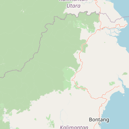
Understand where Kutai National Park sits in Indonesia through a broader geographic reading of the surrounding landscape, nearby location context, and its mapped position within the national park landscape.

How Kutai National Park fits into Indonesia

Indonesia is a vast archipelagic nation in Southeast Asia and Oceania, spanning over 17,000 islands between the Indian and Pacific Oceans. As the world's fourth-most populous country with 288 million people, it features extraordinary cultural and biological diversity, withJavanese and Sundanese being the largest ethnic groups. The country gained independence from the Netherlands in 1945 and operates as a unitary presidential republic.

Wider geography shaping Kutai National Park in Indonesia

Indonesia is situated in Southeast Asia and Oceania, spanning the equatorial region between the Indian Ocean to the west and the Pacific Ocean to the east. The archipelago includes major islands such as Sumatra, Java, Sulawesi, and parts of Borneo and New Guinea. It borders Papua New Guinea, Timor-Leste, and Malaysia by land, with extensive maritime boundaries throughout the region.

Map view of Kutai National Park

Use this park location map to pinpoint Kutai National Park in Indonesia, understand its exact geographic position, and read its mapped placement within the surrounding landscape more clearly.

Pigeon | © OpenStreetMap contributors

Location context for Kutai National Park

East Kalimantan
Park atlas

Compare the lowland rainforest and freshwater ecosystems of East Kalimantan with other protected landscapes across the region.

Discover Other National Parks and Protected Areas Near Kutai National Park, Borneo
After exploring Kutai National Park's lowland rainforests, map other national parks and protected areas across East Kalimantan, Indonesia, home to diverse ecosystems. This focused view allows you to compare conservation landscapes, trace regional biodiversity, and understand the spread of protected zones within Borneo's complex terrain.
National parkNorth Kalimantan

Kayan Mentarang National Park: A Protected Landscape in North Kalimantan

Explore Borneo's critical protected area and its vast forest geography.

Kayan Mentarang National Park is an immense protected area in North Kalimantan, Indonesia, renowned for being a crucial part of the Heart of Borneo conservation initiative. This national park encompasses over 13,600 square kilometers of primary tropical rainforest, sheltering diverse montane and lowland habitats along the Indonesia-Malaysia border. Its importance lies in its vast, contiguous landscape, critical role in regional biodiversity, and its representation of one of Southeast Asia's last great wilderness expanses, offering significant insight into mapped protected areas.

Area
13,605 km²
Established
1996
IUCN
II
Scope
Mixed
National parkCentral Sulawesi

Lore Lindu National Park: Central Sulawesi's Protected Landscape and Atlas Anchor

Explore its endemic species, megalithic sites, and rich geography.

Lore Lindu National Park stands as a critical protected area within Central Sulawesi, Indonesia, recognized for its exceptional endemic biodiversity and profound archaeological importance. This national park features a dramatic geographic setting, rising from lowland forests to montane ecosystems and encompassing ancient megalithic structures within its protected landscape. Understanding Lore Lindu National Park through its mapped boundaries and unique regional geography offers deep insights into conservation and cultural heritage, providing a focal point for atlas-based discovery.

Area
2,180 km²
Established
1982
IUCN
II
Visitors
2K annual
National parkMiri Division

Usun Apau National Park: National Park with Regional Geographic Context in Miri Division

Explore protected boundaries and mapped landscape details.

Usun Apau National Park represents a distinct protected landscape within the Miri Division, identified as a national park. This entry focuses on its geographic attributes, including its mapped boundaries and its contribution to the regional protected area network. Users can explore Usun Apau National Park to understand its specific role in the geography of Miri Division and to gain context on Malaysia's conservation landscapes.

Area
471.22 km²
Established
2005
IUCN
II
Relief
Mountain
National parkLimbang Division

Pulong Tau National Park: A Protected National Park in Malaysia's Limbang Division

Explore its mapped boundaries and regional landscape context.

Pulong Tau National Park represents a key protected area within the Limbang Division, offering valuable geographic and atlas-based discovery opportunities. This page details the park's identity as a national park, focusing on its mapped boundaries and its role within the protected landscapes of Malaysia. Users can explore the park's specific geographic characteristics and understand its context within the regional atlas, providing a factual foundation for appreciating its natural landscape value.

Area
665.25 km²
Established
1998
IUCN
II
Relief
Mountain
National parkWest Sulawesi

Gandang Dewata National Park: Protected Area Identity and Geographic Context in West Sulawesi

Explore mapped boundaries and regional landscape.

Delve into the protected landscape of Gandang Dewata National Park, a key national park situated in West Sulawesi. This resource offers a detailed geographic perspective, emphasizing its mapped boundaries and its position within the regional atlas. Understand the park's protected-area status and its contribution to the natural geography of Indonesia, serving as a vital point for atlas exploration.

Area
793.42 km²
Established
2016
IUCN
II
Relief
Mountain
National parkWest Kalimantan

Betung Kerihun National Park: West Kalimantan's National Park Geography and Mapped Boundaries

Explore protected area landscape context in Indonesia.

Betung Kerihun National Park is a significant protected area within West Kalimantan, Indonesia, identified as a national park. This entry provides detailed atlas-style exploration of its mapped geographic boundaries and landscape context. Understand its place within the regional geography and the broader network of protected lands, offering a foundation for appreciating its natural setting.

Area
8,000 km²
Established
1995
IUCN
II
Relief
Mountain
National parkSabah

Tawau Hills National Park: Mapped Boundaries and Protected Landscape Identity in Sabah

Explore the geographic scope and regional context of Tawau Hills National Park.

Gain a structured understanding of Tawau Hills National Park as a protected area within the geography of Sabah, Malaysia. This resource details its significance as a national park, highlighting its mapped landscape and its contribution to the regional geographic context. Ideal for users interested in atlas exploration and comprehending the distribution of protected lands.

Area
280 km²
Established
1979
IUCN
II
Relief
Mountain
National parkMarudi District

Gunung Mulu National Park: A Protected National Park with Distinct Geographic Identity in Marudi District

Explore its mapped protected area and regional landscape.

Gunung Mulu National Park stands as a key protected area within Marudi District, Malaysia, offering critical insights into the region's natural geography. This national park entity provides a focal point for understanding mapped protected landscapes and their specific geographic characteristics. Users can explore the park's boundaries and its role within the wider atlas of Malaysian natural areas, gaining a solid foundation in its conservation geography.

Area
528.64 km²
Established
1974
IUCN
II
Relief
Mountain

Common questions about visiting, size, designation, and location context for Kutai National Park

Kutai National Park FAQs for park facts, access, geography, and protected area context
Find quick answers about Kutai National Park, including protected-area facts, park geography, trail and visitor context, and how the park fits into its surrounding country and regional landscape.
MoriAtlas Explorer

Continue Your Protected Areas Search Across the Global Atlas

Deepen your exploration by continuing the structured search for national parks and protected areas worldwide. Utilize the comprehensive filtering capabilities to compare different conservation landscapes and refine your understanding of global park geography. Discover more about the distribution and characteristics of protected natural areas.

Global natural geography