
Mori Atlas logo
Nature reserveLake Neusiedl

A vast endorheic lake system characterized by expansive reed belts and saline steppe environments.

Lake Neusiedl: Exploring the Protected Steppe Lake Landscapes and Pannonian Geography of Austria

Lake Neusiedl serves as a significant endorheic basin at the intersection of the eastern Alps and the Pannonian Plain. This nature reserve, straddling the border between Austria and Hungary, contains the second largest contiguous reed belt in Europe. The surrounding terrain of flat saline plains and periodically flooded pans supports a complex migratory ecosystem and a long, layered human history of settlement.

steppe lakeendorheic lakesaline lakereed beltcross-border protected areaUNESCO World Heritage

Lake Neusiedl

Nature reserve

Park overview

Structured park overview, official facts, and landscape profile for Lake Neusiedl

Lake Neusiedl park facts, protected area profile, and essential visitor context

Review the core facts for Lake Neusiedl, including designation, size, terrain, visitor scale, habitats, and operating context in one park-focused overview.

About Lake Neusiedl

Lake Neusiedl is a defining geographic feature of the Austro-Hungrian borderland, lying in the climatic and ecological transition zone where the eastern Alps meet the Pannonian Plain. The lake sits in the Little Hungarian Plain (Kisalföld), framed by the Leitha Mountains to the northwest, the Sopron Mountains to the south, and the flat Parndorf Plateau and Seewinkel to the east. Politically, roughly three quarters of its surface lies in Burgenland, Austria, with the remainder in Hungary, while its drainage basin extends across both countries.

As a steppe lake, Lake Neusiedl is exceptionally shallow, on average around one meter deep, and never exceeds about 1.8 meters. Its water is mildly saline, with sodium carbonate (locally called "Zick"), sodium sulfate, magnesium sulfate, and sodium chloride contributed by groundwater interaction with ancient marine sediments. Because the lake has no natural outflow, water levels have fluctuated dramatically through history, with the lake having vanished entirely multiple times in recorded centuries and been documented as growing far larger in wet periods.

The reserve system built around the lake is unusually mature. The Austrian Neusiedler See-Seewinkel National Park was formally recognized as an IUCN Category II protected area in 1993, and the Hungarian Fertő-Hanság National Park holds the larger cross-border share of the protected landscape. UNESCO inscribed the Fertő/Neusiedlersee Cultural Landscape on the World Heritage List in 2001, and the lake and its surroundings are also designated under the Ramsar Convention on Wetlands, with two separate Ramsar sites bearing on the cross-border area.

For visitors and residents, Lake Neusiedl serves as both a working agricultural landscape and a recreational hub. Wines from the surrounding region, sailing and windsurfing on its open waters, the cycling path encircling the lake, and the cultural attractions of towns such as Rust, Fertőd, and Fertőrákos all contribute to its identity. The lake remains, however, environmentally fragile, with concerns over water loss driven by reduced precipitation, reed encroachment, and rising temperatures shaping current management debates.

Quick facts and research context for Lake Neusiedl

Lake Neusiedl (German: Neusiedler See; Hungarian: Fertő tó) is a large saline steppe lake of endorheic character, situated partly in the Austrian state of Burgenland and partly in western Hungary. Its mean elevation is roughly 115 meters above the Adriatic, and despite covering several hundred square kilometers, it never exceeds about 1.8 meters in depth.

Nearly half of the lake's surface is overgrown with reeds, forming a continuous Phragmites belt that encircles nearly the entire shore. The lake was named European Landscape of the Year in 1990, and the surrounding cultural landscape has been on the UNESCO World Heritage List since 2001 under the designation Fertő/Neusiedlersee Cultural Landscape.

Protection and recognition

Documented management scope, designation history, and international recognition details

Lake Neusiedl Protection Status and Transboundary Designation Records

Lake Neusiedl features a mixed protection scope established through transboundary designation records dating from 2001. Official conservation data compiles management parameters and recognized status values across the shared protected landscape.

Protection details

Protection scope
Mixed
Designated year
2001
Transboundary protection
Yes
Park context

Deeper park guide and search-rich context for Lake Neusiedl

Lake Neusiedl history, landscape, wildlife, and travel context

Explore Lake Neusiedl through its history, landscape character, ecosystems, wildlife, conservation priorities, cultural context, and seasonal travel timing in a structured park guide built for atlas discovery and search intent.

Why Lake Neusiedl stands out

Lake Neusiedl is most renowned for its enormous reed belt, which after the Danube Delta is the largest contiguous area of Phragmites in Europe. The reeds sustain an exceptionally rich birdlife, hosting the largest breeding colony of great egrets in Central Europe, and the lake functions as a key migratory bird refuge. The shoreline is also strongly associated with the white stork, whose nests are a regional symbol. Equally distinctive is the lake's identity as a true steppe lake in a European context: shallow, slightly saline, endorheic, and historically unpredictable in its water levels. The surrounding cultural landscape, shaped by Hallstatt, Roman, Hungarian, and Esterházy-era settlement and land use, has been recognized by UNESCO as a combined natural and cultural heritage site.
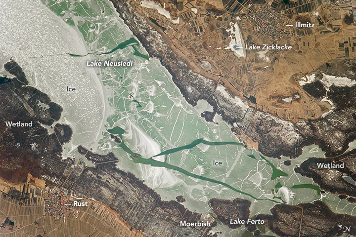
Lake Neusiedl from space
An aerial view of the southern end of Lake Neusiedl, captured from the International Space Station, showing open water amidst ice during the spring thaw.

Lake Neusiedl history and protected-area timeline

Human settlement around Lake Neusiedl goes back at least to the Neolithic, with continuous occupation from roughly 6000 BC. By the seventh century BC the surrounding lowlands were densely populated, initially by communities associated with the Hallstatt culture, and the area remained an inhabited crossroads through Roman, Migration-era, medieval, and early modern times. The Romans knew the lake as Lacus Peiso or Pelso, used the dense oak forests of the Seewinkel for timber at Carnuntum, and established vineyards here at the latest under Emperor Probus.

Medieval settlement was disrupted by the Mongol invasions of 1242 and repopulated in stages through south German colonization, the founding of Neusiedl am See deriving its name from this resettlement. The Hungarian name Fertő, first documented as Stagnum Ferteu in 1074, has been used in various forms for centuries and reflects the lake's fluctuating character between marsh, river, and open water. The Esterházy family's eventual dominance, beginning in the 17th century, gave the region a long association with the great Hungarian noble house, which still owns much of the Austrian lake area.

In the 19th and early 20th centuries, the lake was repeatedly threatened with artificial drainage. Plans in 1918 came close to partitioning the lake bed for agriculture but were halted by the collapse of Austria-Hungary at the end of World War I and Burgenland's transfer to Austria in 1921. Further drainage schemes resurfaced across the 20th century, including proposed Danube diversions during the 1930s. By the late 20th century, the conservation movement prevailed: the 1971 cancellation of a planned road bridge across the Austrian part of the lake, after protests led by figures such as Klara Köttner-Benigni, was a turning point that galvanized the modern national park movement.

The 1993 designation of the Austrian Neusiedler See-Seewinkel National Park as an IUCN Category II area, followed by Hungary's expansion of Fertő-Hanság National Park to roughly 23,500 hectares, established the cross-border protection framework. UNESCO's 2001 inscription of the Fertő/Neusiedlersee Cultural Landscape recognized this combined natural and cultural value. More recent history has been characterized by growing concern over climate-related desiccation, bilateral water management between Austria and Hungary (formalized since 1956), and the founding in 2022 of the cross-border Seemanagement GmbH to coordinate conservation responses to the lake's vulnerability.

Lake Neusiedl landscape and geographic character

The defining landscape feature of Lake Neusiedl is its encircling reed belt, which covers roughly half of the lake's surface area and forms the second-largest contiguous reed habitat in Europe after the Danube Delta. This Phragmites ring varies in width: at Donnerskirchen it reaches up to five kilometers across, while along most of the eastern shore it is much narrower. Only the beach at Podersdorf am See offers a reed-free stretch of shore of meaningful length. Within the belt, passages called "Schluichten" and small open islands known as "Schoppen" create an intricate mosaic of open water and marsh.

Around the lake, the terrain is exceptionally flat, typical of the Pannonian lowlands. The Parndorfer Platte stretches north of the lake, the Heideboden to its east, and the Seewinkel, a triangular area between the southern part of the lake and the Hungarian border, consists of saline steppe and small, periodically flooded "Lacken" (pans). To the northwest, the Leitha Mountains form a low but scenic rise, while south of the lake lie the Sopron Mountains and the Ruster Hügelland, a small, vineyard-rich hill country.

The lake's geography is in a constant state of slow ecological change. Stratigraphic records show the lake has dried up entirely more than a hundred times since its formation at the end of the last glacial period. Anthropogenic effects are layered on top: the opening of the Einserkanal in 1909, the introduction of agricultural nutrient runoff, and the bilateral water-level regulation initiated in 1965 have together transformed the shoreline. Today, the open water is significantly narrower than the historical maximum, and the reed belt has expanded substantially over the last century.
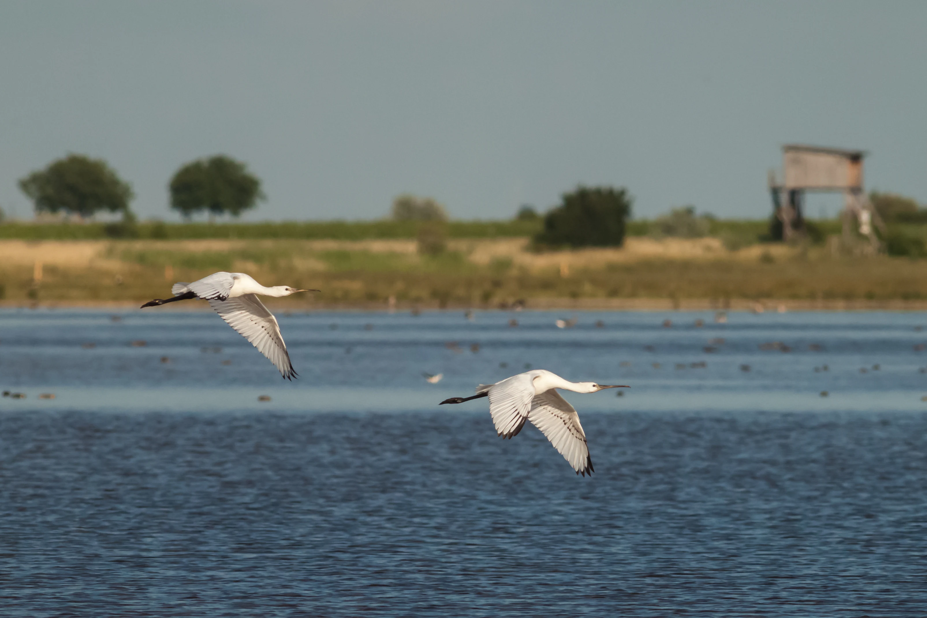
Spoonbill landing in Lake Neusiedl National Park
A spoonbill bird in flight at Lake Neusiedl-Seewinkel National Park in Austria.

Lake Neusiedl ecosystems, habitats, and plant life

Ecologically, Lake Neusiedl sits in the Pannonian floristic province, a region marked by continental, relatively dry conditions and a distinctive mixture of Central European and Eastern European steppe species. The lake and its surroundings support an unusual combination of saline, freshwater, marshland, steppe, and forest-edge habitats within a small area, which is the basis of its conservation importance.

The lake's hydrology produces mildly saline water that encourages halophytic plant communities resembling those of sea coasts, especially in the Seewinkel pans and dry lakebed margins. Plants adapted to saline soils, including Salzkresse, Salz-Wermut, Strand-Aster, and the distinct inland Strand-Melde Atriplex intracontinentalis, grow in these areas. On non-saline dry meadows, the protected Austrian flax, the Zwerg-Schwertlilie, and several orchid species, including the Sumpf-Glanzkraut and the Gelber Frauenschuh, still survive. Carnivorous bladderworts (Utricularia) inhabit the so-called Blänken, small clear pools within the reed belt.

On the water side, the reed belt is more than just a single species: alongside Phragmites, the area supports Knollenbinse, salt-rushes, sedges, and the Pannonian flatsedge. The reed belt's ecological role is profound; it filters nutrients, stabilizes sediments, and provides breeding and feeding habitat for fish, amphibians, and birds. Reed harvesting in winter is both traditional and ecologically managed, supporting regional industry while helping to remove excess biomass from the lake.
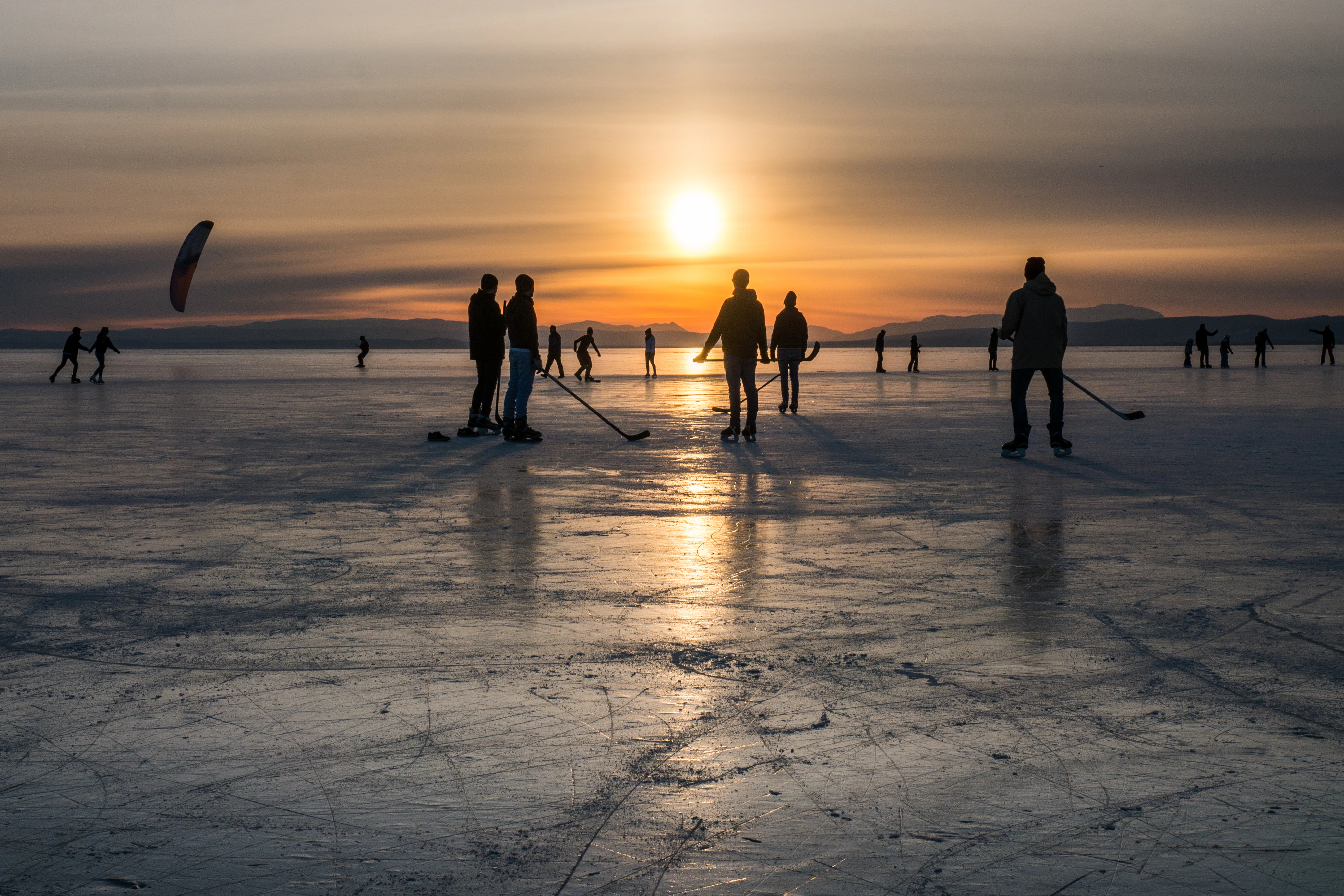
Evening mood on the ice
When the ice is thick enough, many activities are possible on Lake Neusiedl.

Lake Neusiedl wildlife and species highlights

Lake Neusiedl is one of Europe's most important sites for birdlife. Over 300 bird species have been recorded, of which roughly 150 breed in the area; this represents around 40 percent of all European bird species and 80 percent of all Austrian bird species. The lake holds one of the largest breeding populations of great egrets in Europe, with up to 700 pairs, plus grey herons (around 35 breeding pairs), and a small but internationally significant population of great bustard (about 70 pairs). White storks are so strongly associated with the region that their large nests are widely treated as a regional symbol.

Migratory waterbirds use the lake, reed belt, and Seewinkel pans as a critical staging and wintering area along the East Atlantic and Black Sea flyways. Spoonbills, purple herons, pied avocets, ruffs, Kentish plovers, common terns, black-tailed godwits, common redshanks, and Eurasian curlews are among the regularly recorded species. Raptors and other notable birds such as eastern imperial eagles, white-tailed eagles, golden orioles, European bee-eaters, short-eared owls, and Montagu's harriers add further biodiversity interest.

Mammal diversity is more modest but still meaningful. Over 40 mammal species have been recorded, including the European ground squirrel (Ziesel), the steppe polecat (Steppeniltis), and the European hamster. Reptiles include grass snakes, dice snakes, and several lizard species, although the once-present meadow viper has not been reliably observed since 1973. In summer, when temperatures rise, mosquitoes and biting insects can be abundant in the reed belt.
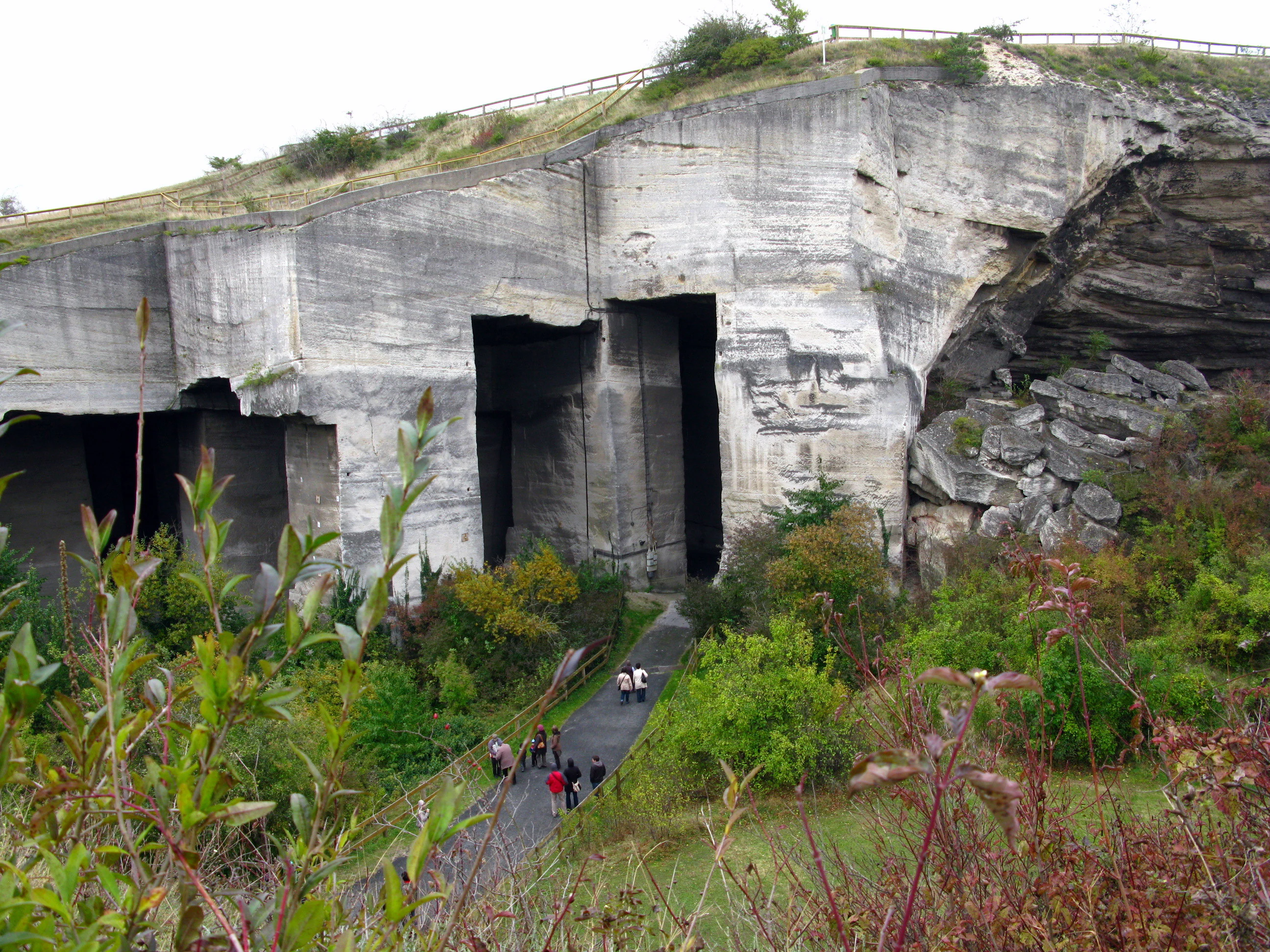
Fertorakosi Episcopal Quarry
The historic episcopal stone quarry located in Fertorakosz, near Lake Neusiedl, Hungary.

Lake Neusiedl conservation status and protection priorities

The ecological significance of the Lake Neusiedl area is the foundation of an unusually layered system of international and national protections. The Austrian side of the lake and its eastern surroundings were formally established as Neusiedler See-Seewinkel National Park in 1993 and recognized as an IUCN Category II protected area. On the Hungarian side, Fertő-Hanság National Park is considerably larger (around 23,500 hectares), and together the two parks form one of Central Europe's most important cross-border conservation complexes.

In 2001, UNESCO inscribed the Fertő/Neusiedlersee Cultural Landscape as a World Heritage Site under cultural criterion (v), recognizing that the lake landscape reflects an evolving cultural tradition of human settlement and land use over many centuries. Two Ramsar sites, the Austrian "Neusiedlersee, Seewinkel & Hanság" designated on 16 December 1982, and the Hungarian "Lake Fertő" designated on 17 March 1989, add international wetland protection. The area also falls under Natura 2000 protections on both sides of the border.

The lake's present conservation priorities are climate-related. Water levels have repeatedly set record lows in recent decades, including a marked drop during the 2003 European heatwave and dramatic low stands in summers such as 2022, when water temperatures above 30 °C triggered fish die-offs. Biodiversity concerns include reed encroachment (the reed belt has expanded by roughly 100 km² in Austria since 1909), the loss of open sand and salt-pan habitats, and the management dilemmas posed by introducing species such as European eel and Prussian carp in former decades.

Lake Neusiedl cultural meaning and human context

The area around Lake Neusiedl has been continuously inhabited for roughly eight thousand years and carries cultural layers from many periods. Neolithic and Bronze Age remains underlie a region later shaped by Hallstatt culture, Roman villas, a 3rd-century Mithras temple at Fertőrákos, and Ostrogothic presence (Theodoric the Great was reportedly born at the lake in 454). The Esterházy family has been the dominant cultural and economic presence since the 17th century, and the southern Hungarian side retains UNESCO-listed estate palace architecture at Fertőd (the Eszterháza complex).

Local languages and architectural traditions reflect the region's borderland character. Bilingual street names throughout the Burgenland lakeshore preserve the long Hungarian-German cultural interface. Traditional wine taverns (Heurige), wine production in the Neusiedler See and Leithaberg wine regions, fishing as a traditional Livelihood, and the long use of reed in thatched roofing and decorative architecture all continue to define cultural identity. Annual open-air operetta at the Seefestspiele Mörbisch, opera productions in the St. Margarethen quarry, and various cultural venues on the Hungarian shore, including a concert hall cut into a former limestone quarry at Fertőrákos, extend the lake's cultural role into the present.

Lake Neusiedl panorama from the west
A view of Lake Neusiedl taken from the vineyards of Rust, located on the west side of the lake.

Top sights and standout views in Lake Neusiedl

The lake's most distinctive single feature is its massive reed belt, encircling nearly the entire shoreline and creating the second-largest contiguous Phragmites wetland in Europe after the Danube Delta. The lake's status as a true saline steppe lake at the climatic crossroads between the Alps and the Pannonian Plain gives it a uniquely Central European ecological profile.

Beyond its ecological identity, Lake Neusiedl stands out for its long, layered human history, from Neolithic settlement through Roman, Magyar, and Esterházy-era influence, which together with its natural environment earned it recognition as the UNESCO Fertő/Neusiedlersee Cultural Landscape in 2001. Cultural and recreational highlights include Rust's wine culture, the cross-border Neusiedler See cycling path, the Seefestspiele Mörbisch, and the historic Esterházy estates at Fertőd.
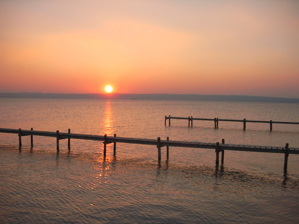
Podersdorf North Beach at sunset
Evening atmosphere at the North Beach of Podersdorf, Lake Neusiedl, captured in summer 2004.

Best time to visit Lake Neusiedl

Lake Neusiedl has a strongly seasonal character that shapes the visitor experience. Late spring and summer are the most popular periods, bringing warm water (average summer temperatures around 22-23 °C), the lake's high recreational profile, and the best opportunities for sailing, windsurfing, cycling, and open-air cultural events like the Seefestspiele Mörbisch. Birding is especially rewarding in spring migration and again during autumn passage, while the unique Blänken pools and abundant breeding activity make early summer a strong choice for naturalists.

In mild autumns, the lake's thermal mass extends the season, and the surrounding vineyards are at their most picturesque during harvest. In colder winters, when the lake freezes, the surface occasionally becomes one of the largest natural ice-skating areas in Central Europe, supporting ice sailing, ice skating, and ice-kiting in exceptional years. Visitors should note that low summer water levels have become more frequent in recent years, which can affect access to swimming areas and boat launches.

Monthly climate preview

Long-term representative point measurements tracking monthly temperature and precipitation rhythms

Lake Neusiedl Climate Normals, Annual Temperature and Precipitation Patterns

Long-term records reveal measured shifts in monthly temperature and precipitation across the representative elevation of Lake Neusiedl. Exploring the complete twelve-month climatology profile provides deeper analytical insight into annual meteorological trends.
Annual mean11 °C
-1 °C22 °C
Jan-1°
Feb
Mar
Apr11°
May16°
Jun20°
Jul22°
Aug22°
Sep16°
Oct10°
Nov
Dec
Warmest month
July

22.4 °C

Coolest month
January

-1.4 °C

Wettest month
June

2.4 mm/day

Driest month
February

1.1 mm/day

Park location guide

Geography guide, regional context, and park location map for Lake Neusiedl

Lake Neusiedl park geography, regions, and map view in Austria

Understand where Lake Neusiedl sits in Austria through a broader geographic reading of the surrounding landscape, nearby location context, and its mapped position within the national park landscape.

How Lake Neusiedl fits into Austria

Austria is a landlocked country in Central Europe, bordered by Germany, Czech Republic, Slovakia, Hungary, Slovenia, Italy, Switzerland, and Liechtenstein. The country is a federal semi-presessional republic composed of nine states, with Vienna as its capital and largest city. It has a population of approximately 9.1 million people.

Wider geography shaping Lake Neusiedl in Austria

Austria is located in Central Europe, lying in the Eastern Alps. It is bordered by Germany and Czech Republic to the north, Slovakia to the northeast, Hungary to the east, Slovenia and Italy to the south, and Switzerland and Liechtenstein to the west.

Map view of Lake Neusiedl

Use this park location map to pinpoint Lake Neusiedl in Austria, understand its exact geographic position, and read its mapped placement within the surrounding landscape more clearly.

Pigeon | © OpenStreetMap contributors

Visual reference for steppe habitats, vast reed belts, and Pannonian terrain

Lake Neusiedl Photos and Protected Landscape Scenery

Explore detailed photography documenting the expansive reed beds, shallow saline waters, and flat Pannonian steppe surrounding Lake Neusiedl. These visual records illustrate the distinctive habitats and protected terrain that define this cross-border Central European sanctuary.

Lake Neusiedl from space

Lake Stage at Morbisch

Spoonbill landing in Lake Neusiedl National Park

Evening mood on the ice

Fertorakosi Episcopal Quarry

Podersdorf North Beach at sunset

Lake Neusiedl panorama from the west

Podersdorf North Beach at sunset

Salt pond at Podersdorf

Neusiedler See-Seewinkel National Park

Lake Neusiedl at Podersdorf

Yachting at Rust am See

Lighthouse at Podersdorf

Neusiedl Lake bathing bay

Ice skating at Lake Neusiedl

Sun Dancer boat tour at Podersdorf am See

Park atlas

Compare adjacent wetland reserves, Pannonian steppe habitats, and cross-border protected landscapes

Explore National Parks and Protected Areas Near Lake Neusiedl

Continue exploring regional park geography by comparing adjacent protected areas near Lake Neusiedl. Discover connected conservation landscapes and expand your understanding of Central European wetland habitats.
Watercolor painting showing a landscape with rolling terrain, water features, and distant mountains
National parkBurgenland
About 3 km away#1 closest

South

Neusiedler See-Seewinkel National Park: Protected Steppe Lake Landscape in Burgenland

Explore mapped wetland geography and birdwatching significance.

Neusiedler See-Seewinkel National Park showcases a rare steppe lake environment and extensive wetland habitats at the eastern edge of Austria, within the Burgenland region. This protected area is globally recognized for its exceptional avian diversity and the unique ecological mosaic formed by reed beds, salt marshes, and seasonal pools. Explore its mapped boundaries and distinctive Pannonian geography for a deep understanding of this vital European protected landscape.

Area
97 km²
Established
1993
IUCN
II
Relief
Lowland
Watercolor illustration of a landscape with green hills, a body of water, and trees under a soft sky
National parkGyőr-Moson-Sopron
About 11 km away#2 closest

South

Fertő-Hanság National Park: Central European Wetland and Salt Lake Protected Area

Mapped Geographic Boundaries and Landscape Context

Fertő-Hanság National Park, situated in Győr-Moson-Sopron, Hungary, is a vital protected landscape renowned for its shallow salt lake and expansive marshlands. This page provides an atlas-focused discovery of its protected area, highlighting the unique interplay of reed beds and alkaline grasslands. Understand the park's geographic setting and its role as a significant wetland ecosystem for bird populations and specialized flora.

Area
235.88 km²
Established
1991
IUCN
II
Relief
Lowland
National parkLower Austria
About 31 km away#3 closest

North

Danube-Auen National Park: Protected Floodplain Ecosystem and Regional Geography

Mapped boundaries and vital riparian landscape in Lower Austria.

Delve into the unique protected landscape of Danube-Auen National Park, a cornerstone of Central European riparian conservation. This page offers detailed insights into its mapped boundaries, the dynamic interplay of river channels, lowland forests, and wetlands, and its significant role within the geographic context of Lower Austria. Understand the atlas value of this protected area, ideal for discovering rich natural terrain and ecosystem context.

Area
93 km²
Established
1996
IUCN
II
Relief
Lowland
Nature reserveLower Austria
About 35 km away#4 closest

Northeast

Hundsheimer Berg Nature Reserve: Protected Landscapes of the Lower Austrian Carpathians

Mapped dry steppe, karst topography, and pannonian forest habitats

Rising abruptly from the Danube lowlands, Hundsheimer Berg preserves a compact range of crystalline and limestone hills. This nature reserve provides vital insights into the pannonian biogeographic region, featuring a diverse mosaic of rocky slopes and dry grasslands that support a high concentration of rare insects and plants.

Area
1.66 km²
Established
1965
IUCN
IV
Relief
Mountain
Nature reserveLower Austria
About 35 km away#5 closest

Northeast

Spitzerberg Nature Reserve: Geography and Protected Landscapes of Lower Austria

A vital conservation site featuring arid rock steppes and limestone slopes.

Located in the province of Lower Austria, Spitzerberg serves as a essential nature reserve protecting a rare concentration of Pannonian dry habitats. The site is defined by its steep-sided hill structure, rocky limestone outcrops, and thin soils that support a variety of specialized plant and animal species adapted to this arid environment.

Area
226 km²
Established
1981
IUCN
IV
Relief
Upland
Nature reserveVienna
About 43 km away#6 closest

Northwest

Lobau Nature Reserve: Mapping the Protected Danube Floodplain Landscapes of Vienna

Riparian forests, oxbow lakes, and historic wetland ecosystems.

Lobau preserves the ecological memory of the Danube through a landscape of slow-moving water bodies and dense forest stands. Situated within Vienna, this protected area features a distinct topography of dry gravel terraces, reedy ponds, and riparian corridors, offering significant insights into the region's natural history and riverine geography.

Area
22 km²
Established
1905
Relief
Lowland
Climate
Temperate
Nature reserveLower Austria
About 53 km away#7 closest

West

Hohe Wand Nature Park: Mapped Geography and Protected Landscapes in Lower Austria

A limestone plateau mountain at the Alpine-Pannonian transition

Located in Lower Austria, Hohe Wand Nature Park encompasses a distinct limestone plateau and dramatic southeastern cliffs. Its protected status reflects the convergence of Alpine and Pannonian geography, offering a unique opportunity to study karst geology, exposed cliff habitats, and the transition zone between high mountain ranges and the Vienna Basin lowlands.

Relief
Mountain
Climate
Temperate
Access
Easy access
Scope
Terrestrial
Protected landscapeLower Austria
About 69 km away#8 closest

Northwest

Vienna Woods: Protected Landscape, Forested Highlands, and Alpine Foothill Geography

Natural terrain and protected boundaries in Lower Austria

The Vienna Woods encompass a distinct geographic region where sandstone ridges meet limestone formations. This protected landscape provides a dense network of forest habitats, river gorges, and significant peaks overlooking the Danube. Its structure traces the edge of the Alps, offering a rich study in regional geology, elevation gradients, and the intersection of natural wilderness with the surrounding basin environment.

Area
1,056.45 km²
Established
1987
Relief
Mountain
Climate
Temperate

Common questions about visiting, size, designation, and location context for Lake Neusiedl

Lake Neusiedl FAQs for park facts, access, geography, and protected area context

Find quick answers about Lake Neusiedl, including protected-area facts, park geography, trail and visitor context, and how the park fits into its surrounding country and regional landscape.
MoriAtlas Explorer

Continue Your Protected Areas Search Across the Global Atlas

Deepen your exploration by continuing the structured search for national parks and protected areas worldwide. Utilize the comprehensive filtering capabilities to compare different conservation landscapes and refine your understanding of global park geography. Discover more about the distribution and characteristics of protected natural areas.

Global natural geography