Mori Atlas logo
National parkLake Sentarum National Park

Discover the mapped geographic boundaries and ecological significance of this Indonesian national park.

Lake Sentarum National Park: A Protected Wetland Landscape in Indonesia's Archipelago

Lake Sentarum National Park stands as a significant protected area within Indonesia, characterized by its expansive lake ecosystems and wetland environments. Situated in the vast archipelagic nation, this national park offers a crucial point for understanding regional geography and conservation landscapes. Users exploring MoriAtlas can delve into the mapped boundaries of Lake Sentarum National Park to appreciate its specific terrain and ecological context within Borneo, gaining insight into the unique natural heritage it preserves.

wetlandslake ecosystemsIndonesiaBorneotropical protected areaKapuas Hulu

Lake Sentarum National Park

National park

Park overview

Structured park overview, official facts, and landscape profile for Lake Sentarum National Park

Lake Sentarum National Park park facts, protected area profile, and essential visitor context

Review the core facts for Lake Sentarum National Park, including designation, size, terrain, visitor scale, habitats, and operating context in one park-focused overview.
Protection and recognition

Verifying the official conservation status and administrative timeline of the reserve.

Lake Sentarum National Park Protection Status and Official Designation

Official records trace the conservation framework of Lake Sentarum National Park back to its designation in 1994. Tracking documented database profiles helps researchers map global conservation boundaries and analyze regional environmental management frameworks.

Protection details

Designated year
1994
Transboundary protection
No
Monthly climate preview

Long term temperature and monthly precipitation averages for Indonesia

Lake Sentarum National Park Climate Normals and Annual Weather Patterns

Representative coordinate measurements show consistent annual temperatures alongside distinct monthly precipitation variations across the protected landscape. Examining the full twelve month record clarifies long term climate normals and seasonal weather patterns.
Annual mean25 °C
25 °C26 °C
Jan25°
Feb25°
Mar26°
Apr26°
May26°
Jun26°
Jul25°
Aug25°
Sep25°
Oct25°
Nov25°
Dec25°
Warmest month
May

26 °C

Coolest month
January

25.2 °C

Wettest month
December

12.5 mm/day

Driest month
July

6.5 mm/day

Park location guide

Geography guide, regional context, and park location map for Lake Sentarum National Park

Lake Sentarum National Park park geography, regions, and map view in Indonesia

Understand where Lake Sentarum National Park sits in Indonesia through a broader geographic reading of the surrounding landscape, nearby location context, and its mapped position within the national park landscape.

How Lake Sentarum National Park fits into Indonesia

Indonesia is a vast archipelagic nation in Southeast Asia and Oceania, spanning over 17,000 islands between the Indian and Pacific Oceans. As the world's fourth-most populous country with 288 million people, it features extraordinary cultural and biological diversity, withJavanese and Sundanese being the largest ethnic groups. The country gained independence from the Netherlands in 1945 and operates as a unitary presidential republic.

Wider geography shaping Lake Sentarum National Park in Indonesia

Indonesia is situated in Southeast Asia and Oceania, spanning the equatorial region between the Indian Ocean to the west and the Pacific Ocean to the east. The archipelago includes major islands such as Sumatra, Java, Sulawesi, and parts of Borneo and New Guinea. It borders Papua New Guinea, Timor-Leste, and Malaysia by land, with extensive maritime boundaries throughout the region.

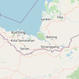
Map view of Lake Sentarum National Park

Use this park location map to pinpoint Lake Sentarum National Park in Indonesia, understand its exact geographic position, and read its mapped placement within the surrounding landscape more clearly.

Pigeon | © OpenStreetMap contributors

Location context for Lake Sentarum National Park

West Kalimantan
Park atlas

Compare adjacent protected landscapes, tracing their geographic spread across Borneo's tropical wetlands near Lake Sentarum National Park.

Discover Other Protected Areas: National Parks Near Lake Sentarum National Park

Browse a curated list of national parks and protected areas situated in the geographic vicinity of Lake Sentarum National Park, focusing on similar wetland and tropical forest ecosystems within Borneo. Use this regional overview to compare conservation landscapes, trace the distribution of protected areas, and deepen your atlas-style understanding of Indonesia's diverse natural heritage.
National parkSri Aman Division
About 40 km away#1 closest

Northwest

Batang Ai National Park: National Park Landscape and Geographic Discovery

Explore the protected terrain and mapped boundaries of Sri Aman Division.

Batang Ai National Park serves as a distinct national park entity, vital for understanding the protected landscape and regional geography of Malaysia's Sri Aman Division. This resource offers detailed insights into the park's geographic scope, its mapped boundaries, and the natural terrain it encompasses, enabling structured exploration for atlas enthusiasts and geography researchers.

Area
24 km²
Established
1991
IUCN
II
Relief
Lowland
National parkWest Kalimantan
About 51 km away#2 closest

East

Betung Kerihun National Park: West Kalimantan's National Park Geography and Mapped Boundaries

Explore protected area landscape context in Indonesia.

Betung Kerihun National Park is a significant protected area within West Kalimantan, Indonesia, identified as a national park. This entry provides detailed atlas-style exploration of its mapped geographic boundaries and landscape context. Understand its place within the regional geography and the broader network of protected lands, offering a foundation for appreciating its natural setting.

Area
8,000 km²
Established
1995
IUCN
II
Relief
Mountain
National parkMalaysia
About 136 km away#3 closest

Northwest

Maludam National Park: Southeast Asian Protected Landscape and National Park Geography

Mapped boundaries and natural terrain in Malaysia.

Maludam National Park offers a focused exploration of protected landscape identity and geographic context within Malaysia. As a designated national park, it serves as a vital component for understanding the distribution of protected areas and their mapped terrain. This detailed entry allows for an appreciation of the park's specific environmental character and its contribution to the broader atlas of natural landscapes in Southeast Asia, facilitating structured discovery for researchers and explorers.

Area
432 km²
Established
2000
IUCN
II
Relief
Lowland
National parkSarawak
About 165 km away#4 closest

Northwest

Rajang Mangroves National Park: Borneo's Premier Mangrove Protected Landscape

Explore the mapped geography and wetland conservation of this Sarawak national park.

Rajang Mangroves National Park is a significant protected area dedicated to preserving the intricate mangrove swamp ecosystems of Sarawak's Rajang River delta. Encompassing a vast expanse of tidal channels and riverine forests, this national park serves as a critical habitat for unique wildlife and plays a vital role in coastal ecological health. Its landscape is defined by the dynamic interface between riverine and marine environments, offering a prime example of wetland conservation within Borneo's broader natural geography and atlas context.

Area
107 km²
Established
2000
IUCN
II
Relief
Lowland
National parkCentral Kalimantan
About 190 km away#5 closest

South

Bukit Baka Bukit Raya National Park: Central Kalimantan's Protected Montane Rainforest Landscape

Explore the geographic core of Borneo's Schwaner mountain range.

Bukit Baka Bukit Raya National Park is a critical national park situated in Central Kalimantan, Indonesia, recognized for its extensive montane tropical rainforests and rugged topography. The park's landscape is dominated by the Schwaner mountain range, featuring prominent peaks like Bukit Raya, and functions as a vital watershed and biodiversity corridor. This protected area offers a rich subject for understanding regional geography, mapped landscapes, and the significance of Borneo's natural heritage within an atlas context.

Area
1,810 km²
Established
1992
IUCN
II
Relief
Mountain
Watercolor illustration of a coastal landscape with a distinctive rock formation, green vegetation, and calm water under a soft sky with distant mountains
National parkKuching Division
About 200 km away#6 closest

Northwest

Bako National Park: Sarawak's Oldest National Park and Coastal Protected Landscape

Explore diverse ecosystems and dramatic mapped geology near Kuching Division.

Bako National Park, the oldest national park in Sarawak, Malaysia, offers a profound study in ecological concentration and geological drama. Covering a mere 27 square kilometers on the Muara Tebas peninsula, it encapsulates seven distinct ecosystem types, from coastal heath forest to mangrove areas, supporting significant biodiversity. The park's protected landscape is defined by its stunning sandstone coastline, carved by the sea into cliffs, arches, and seastacks, providing a unique geographic context. This makes Bako an essential destination for understanding Borneo's environmental diversity and the mapped boundaries of its conservation areas.

Area
27.27 km²
Established
1957
IUCN
II
Relief
Mixed relief
National parkSarawak
About 222 km away#7 closest

Northwest

Santubong National Park: Sarawak's Protected Landscape for Geographic Atlas Exploration

Mapped park boundaries and regional terrain context in Borneo

Delve into Santubong National Park, a significant protected area situated within the diverse geography of Sarawak, Malaysia. This resource provides detailed information on the park's mapped boundaries, allowing for focused exploration of its specific terrain and its role within the regional protected landscape atlas. Understand the geographic identity of Santubong National Park and its contribution to Borneo's conservation mapping.

Area
14.1 km²
Established
2007
IUCN
II
Relief
Mountain
National parkSarawak
About 226 km away#8 closest

Northwest

Kuching Wetlands National Park: Sarawak's Protected National Park Landscape and Geography

Explore the mapped wetland boundaries and regional context.

Gain a structured understanding of Kuching Wetlands National Park, a key protected area in Sarawak, Malaysia. This detailed entry provides insights into its specific geographic identity, mapped park boundaries, and its significance as a national park within the Borneo region's extensive natural landscapes. Discover the atlas value of this protected wetland environment for comprehensive geographic exploration.

Area
84.95 km²
Established
1992
IUCN
II
Relief
Lowland

Common questions about visiting, size, designation, and location context for Lake Sentarum National Park

Lake Sentarum National Park FAQs for park facts, access, geography, and protected area context

Find quick answers about Lake Sentarum National Park, including protected-area facts, park geography, trail and visitor context, and how the park fits into its surrounding country and regional landscape.
MoriAtlas Explorer

Continue Your Protected Areas Search Across the Global Atlas

Deepen your exploration by continuing the structured search for national parks and protected areas worldwide. Utilize the comprehensive filtering capabilities to compare different conservation landscapes and refine your understanding of global park geography. Discover more about the distribution and characteristics of protected natural areas.

Global natural geography