
Lakes
Park geography
Mapped boundaries, terrain elevation records, and alpine landscape features.
Geographic Profile and Landscape Structure of Langtang National Park in Nepal
Analyze the physical scope and regional context of Langtang National Park, spanning 1710 square kilometers across Rasuwa, Nuwakot, and Sindhulpalchok districts. This profile details the high altitude terrain, including summits such as Langtang Lirung and Dorje Lhakpa, alongside the alpine meadows and mountain river networks that define the regional geography.
Nepal's first Himalayan national park, guarding a dramatic valley of high peaks, sacred lakes, and rich cultural heritage
Langtang National Park
Langtang National Park is a protected wilderness area in north-central Nepal, established in 1976 as the country's first Himalayan national park and fourth protected area. The park spans approximately 1,710 square kilometers across the Nuwakot, Rasuwa, and Sindhulpalchok Districts in the central Himalayan region. It encompasses the renowned Langtang Valley, a glaciated high-altitude landscape flanked by dramatic mountain terrain that includes the summit of Langtang Lirung at 7,245 meters, the park's highest point. The protected area is part of the Sacred Himalayan Landscape, a transboundary conservation initiative linking protected areas across Nepal and the Tibet Autonomous Region. Twenty-six village communities reside within the park boundaries, maintaining traditional livelihoods amid one of Nepal's most ecologically diverse mountain environments.
- Location
- Nepal
- Park type
- National park
- Established
- 1976
- Area
- 1,710 km²
- Highest point
- 7,245 m
Location overview
Regional distribution across Nepalese administrative districts
Langtang National Park: Geographic Location and Regional Boundaries
Langtang National Park is located in Nepal, spanning the districts of Nuwakot, Sindhulpalchok, and Rasuwa. Regional records detail domestic borders to clarify official administrative zones and local jurisdictions.
- Countries
- Nepal
- Regions
- Nuwakot District, Rasuwa District, Sindhulpalchok District
- Primary location
- Nepal
- Geographic setting
- Inland
Boundary and coordinates
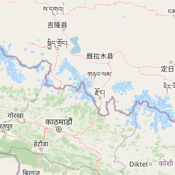
Langtang National Park maps a recorded 1,710 km² extent
Langtang National Park mapped boundary and 1,710 km² area
Langtang National Park’s outline spans a recorded protected extent of 1,710 km². The map communicates the park’s considerable geographic reach while avoiding survey-grade or legal-boundary claims.
- Boundary area
- 1,809.2 km²
- Boundary perimeter
- 234.8 km
- Northernmost point
- 28.3858° N
- Southernmost point
- 27.9624° N
- Easternmost point
- 85.8886° E
- Westernmost point
- 85.1936° E
- Geographic centre
- 28.1397° N, 85.5682° E
- North–south span
- 46.9 km
- East–west span
- 68.2 km
Elevation and terrain
Mountain relief metrics and recorded natural formations across the protected landscape
Langtang National Park Terrain, Elevation Range, and Physical Features
Recorded elevation records place the high point of the protected area at 7245 meters within rugged mountain terrain. Mapped natural feature cards detail individual lakes, streams, peaks, and rivers located inside the park.
- Maximum elevation
- 7,245 m
- Highest point
- 7,245 m
Selected named natural features
Streams
Chhochen Khola
Streams
Chandampari Khola
Lakes
चन्द्रशेखर ताल
Peaks
SN
4,930 m
Viewpoints
Noesagang
Environmental setting
Interpreting alpine climate zones, montane forests, and major water bodies
Langtang National Park Environmental Classification and Physical Setting
Recorded landscape features, habitat types, and alpine climate zones combine to outline the physical setting of the protected area. Stored environmental categories link directly to relevant atlas destinations for broader regional context.
- Relief
- Mountain
- Climate
- Alpine
- Water
- Major water bodies
Landscape features
Mountains · Valleys · Rivers · Lakes
Habitat types
Montane forest · Alpine meadow
Park atlas
Compare Langtang National Park with nearby protected areas, tracing the regional spread of Nepal's high-altitude conservation landscapes.
Explore Parks Near Langtang National Park: Compare Protected Areas and Himalayan Landscapes
Browse national parks and protected areas within or adjacent to the Himalayan terrain surrounding Langtang National Park, exploring a diverse atlas of conservation landscapes. Comparing these protected areas provides valuable geographic context, revealing how varied high-altitude ecosystems are safeguarded across Nepal's rugged mountain regions.
National parkNepal
About 21 km away#1 closest
South

Shivapuri Nagarjun National Park: National Park Mapping and Geographic Identity in Nepal
Explore protected boundaries and natural terrain.
Shivapuri Nagarjun National Park serves as a prime example of a protected natural area within Nepal, offering valuable geographic context for atlas exploration. This detail page provides insights into the park's mapped boundaries, its designation as a national park, and its place within the country's diverse natural landscapes. Understanding the terrain and regional distribution of protected areas like Shivapuri Nagarjun National Park is crucial for a comprehensive geographic perspective.
- Area
- 159 km²
- Established
- 2002
- IUCN
- II
- Relief
- Mountain
National parkKoshi Province
63 km away#2 closest
East
Sagarmatha National Park: Mapped Protected Landscape and Geographic Identity in Koshi Province
Explore the protected area's regional geographic context.
Sagarmatha National Park serves as a distinct protected national park entity. This page facilitates an in-depth understanding of its mapped boundaries and its location within Koshi Province. Users can explore the park's specific landscape characteristics and its position within the broader regional geography, providing a foundation for atlas and map-driven discovery.
- Area
- 1,148 km²
- Established
- 1976
- IUCN
- II
- Visitors
- 19K annual
National parkNepal
70 km away#3 closest
Southwest
Chitwan National Park: Nepal's Designated National Park Landscape
Explore mapped boundaries and surrounding regional geography.
Chitwan National Park is a vital protected area offering critical insights into Nepal's natural geography. This entry provides detailed information on the park's specific landscape characteristics and its mapped boundaries, crucial for anyone interested in the atlas-level understanding of protected lands within South Asia. Discover the geographic context of this national park and its significance within the broader conservation framework of Nepal.
- Area
- 952.63 km²
- Established
- 1973
- IUCN
- II
- Relief
- Mixed relief
National parkNepal
About 105 km away#4 closest
Southwest
Parsa National Park: Mapped Protected Landscape Within Nepal's Geography
Explore its national park status and geographic setting.
Parsa National Park represents a significant protected area within the geographic framework of Nepal. This page provides critical atlas context, detailing the park's mapped boundaries and its role as a national park. It serves as an essential resource for understanding the specific landscape features and regional geographic positioning of Parsa National Park, contributing to a structured view of protected lands across South Asia.
- Area
- 627.39 km²
- Established
- 2017
- IUCN
- II
- Relief
- Lowland
National parkKoshi Province
About 127 km away#5 closest
East
Makalu Barun National Park: Protected Landscape and Regional Geography in Koshi Province
Explore the mapped boundaries of this national park.
Makalu Barun National Park is a designated national park providing critical protected landscape data for geographic discovery. Understand its position within Koshi Province and its specific mapped boundaries, offering insights into Nepal's protected areas. This entry is designed for users seeking detailed atlas information on the park's terrain and its role in regional conservation contexts.
- Area
- 1,500 km²
- Established
- 1992
- IUCN
- II
- Relief
- Mountain
National parkWest Champaran District
About 128 km away#6 closest
Southwest

Valmiki National Park: A Vital National Park and Protected Landscape in Bihar
Explore unique Sivalik terrain and mapped protected area boundaries
Valmiki National Park, located in the West Champaran District of Bihar, is a significant protected area renowned for its unique geography. Situated at the interface of the Himalayas and the Gangetic plains, the park showcases a varied terrain including ridges, gorges, dense forests, and extensive wetlands. As Bihar's only national park and a designated tiger reserve, it offers rich insights into conservation landscapes and regional biodiversity for atlas exploration.
- Area
- 898.45 km²
- Established
- 1990
- IUCN
- II
- Relief
- Mixed relief
National parkSikkim
222 km away#7 closest
East
Khangchendzonga National Park: National Park in Sikkim with Mapped Boundaries
Explore protected landscapes and regional geography.
Understand Khangchendzonga National Park as a key protected area within Sikkim, India. This entry provides focused atlas information on the park's geographic features, mapped boundaries, and its role as a national park, offering essential context for regional landscape discovery and exploration.
- Area
- 1,784 km²
- Established
- 1977
- IUCN
- II
- Relief
- Mountain
Wildlife reserveUttar Pradesh
236 km away#8 closest
Southwest
Bakhira Wildlife Sanctuary: Geographic Overview of India's Major Floodplain Wetland
Mapped wetlands and protected landscape context in Uttar Pradesh
Located in the heart of the Indo-Gangetic plain, Bakhira Wildlife Sanctuary features a complex network of seasonal water bodies and marshes. The sanctuary acts as a primary staging ground for migratory waterfowl, offering deep insights into floodplain hydrology, regional biodiversity, and the interplay between protected wilderness and active agricultural zones.
- Area
- 29 km²
- Established
- 1980
- IUCN
- IV
- Relief
- Lowland
MoriAtlas Explorer
Continue Exploring Langtang National Park's Protected Landscape and Geographic Context
Deepen your understanding of Langtang National Park by exploring its specific mapped boundaries, diverse alpine ecosystems, and position within the wider Himalayan geography. Discover the unique atlas-level details that make this protected area a key point of reference for Nepal's natural heritage and conservation efforts.
Browse next
Global natural geography
Explore related park routes
Explore MoriAtlas Global ParksBrowse All MoriAtlas ParksGlobal Park Map DiscoveryMoriAtlas: Browse All CountriesBrowse All MoriAtlas ContinentsNational Park Environment AtlasGrand Canyon National Park AtlasYellowstone National Park AtlasYosemite National Park Atlas and GeographySerengeti National Park AtlasGalápagos National Park Protected LandscapeBanff National Park Geography and AtlasKruger National Park Atlas EntryUluṟu-Kata Tjuṯa National Park AtlasExplore Uluru-Kata Tjuta National Park GeographyPlitvice Lakes National Park AtlasFiordland National Park Protected LandscapeGreat Smoky Mountains National Park AtlasAfghanistan National Parks and Protected AreasAlbania National Parks and Protected AreasAlgeria National Parks and Protected AreasAmerican Samoa National Parks and Protected AreasAndorra National Parks and Protected AreasAngola National Parks and Protected AreasAntarctica National Parks and Protected AreasAntigua and Barbuda Park List