
Forests
Park geography
Detailed analysis of territorial boundaries, riverine networks, and forest geography
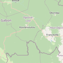
Comprehensive Geographic Profile and Mapped Landscape Context for Lopé National Park
Analyze the precise geographic extent and physical character of Lopé National Park within Gabon. This profile covers the 4,910 square kilometer protected area, detailing its diverse mix of tropical forests, savanna grasslands, and the extensive network of river systems like the Ogooué and Offoué.
Related tags
RainforestSavannaWorld Heritage SitePrimatesForest Elephants
Gabon's ecological crossroads where ancient savannas meet tropical rainforests
Lopé National Park
Lopé National Park is a national park in central Gabon, covering approximately 4,910 square kilometers of territory that represents one of Central Africa's most ecologically significant landscapes. The park is situated along the Ogooué River Valley, bordered to the north by the river itself and to the south by the Chaillu Massif, creating a unique transition zone between different ecological systems. What makes Lopé particularly remarkable is its position as a mosaic landscape where dense tropical rainforests intermingle with rare savanna ecosystems, a configuration that exists in very few other places on the continent. The park holds special global significance as a UNESCO World Heritage Site, recognized in 2007 for its outstanding universal value encompassing both biodiversity and cultural heritage. This dual recognition reflects the park's extraordinary combination of ecological importance and archaeological significance, with evidence of continuous human occupation spanning nearly 400,000 years.
- Location
- Gabon
- Park type
- National park
- Established
- 2002
- Area
- 4,910 km²
Location overview
Analyzing regional placement and national jurisdiction in Gabon
Mapping the Geographic Setting of Lopé National Park in Gabon
Lopé National Park is situated entirely within the national borders of Gabon as a protected terrestrial territory. Geographic records show no transboundary divisions, placing the park under a single national jurisdiction.
- Countries
- Gabon
- Primary location
- Gabon
Boundary and coordinates
Lopé National Park’s mapped boundary frames 4,910 km²
Lopé National Park mapped boundary and 4,910 km² area
Lopé National Park has atlas geometry spanning a documented 4,910 km². The outline conveys the national park’s extensive footprint and geographic setting without representing official survey limits.
- Boundary area
- 4,955.4 km²
- Boundary perimeter
- 489.5 km
- Northernmost point
- 0.057° S
- Southernmost point
- 1.0843° S
- Easternmost point
- 11.8567° E
- Westernmost point
- 11.2627° E
- Geographic centre
- 0.5252° S, 11.5417° E
- North–south span
- 113.6 km
- East–west span
- 66.1 km
Terrain and natural features
Explore mixed relief classifications and recorded natural landmarks
Lopé National Park Terrain and Named Natural Features
Stored terrain classifications and recorded natural features document the mixed relief within Lopé National Park. Linked feature cards supply specific names, types, measurements, and spatial relationships.
Selected named natural features
Peaks
Mont Brazza
405 m
Rivers
Ogooué River
Rivers
Mingoué
Rapids
Rapides de Banya
Rivers
Lélédi
Environmental setting
Recorded tropical forest habitats, river networks, and mixed relief zones
Lopé National Park Environmental Classifications and Physical Settings
Stored classifications organize dominant forest cover, tropical climate zones, and seasonal patterns into complementary physical settings. Connected atlas categories link recorded environmental metrics directly to related protected geography.
- Relief
- Mixed relief
- Climate
- Tropical
- Water
- Major water bodies
- Forest cover
- Dense forest cover
- Seasonality
- Seasonal
Landscape features
Forest · Grassland · Rivers · Hills · Mountains
Habitat types
Tropical forest · Savanna · Riverine habitat
Park atlas
Map the protected areas and diverse landscapes bordering Lopé National Park, exploring Central Africa's rich ecological spread.
Discover More National Parks and Protected Areas Near Lopé National Park, Gabon
After exploring Lopé National Park's unique rainforest and savanna ecosystems, browse other protected areas within Gabon and across the broader Central African region. Compare diverse conservation landscapes, examine regional park distribution, and understand the geographic context of similar protected zones in this vital atlas view.
National parkGabon
21 km away#1 closest
Southwest

Waka National Park: A Mapped Protected Landscape in Gabon's Geography
Explore the natural terrain and park boundaries of this national park.
Waka National Park in Gabon represents a vital protected landscape for geographic exploration. This dedicated detail page offers insight into the park's specific mapped area and its place within the country's broader natural terrain. Understand its context as a national park, contributing to the atlas of protected areas in Central Africa. Discover the geographic identity of this significant natural reserve.
- Area
- 1,060 km²
- Established
- 2002
- IUCN
- II
- Relief
- Mountain
National parkGabon
About 98 km away#2 closest
Northeast
Ivindo National Park: A Protected Rainforest Landscape in Gabon
Explore its waterfalls, diverse ecosystems, and mapped geographic context.
Ivindo National Park represents a significant protected landscape within Gabon, spanning a vast area of intact tropical rainforest. Recognized as a UNESCO World Heritage Site, the park is defined by the Ivindo River and its dramatic waterfalls, including the famous Kongou and Mingouli Falls. Its geography includes mountainous terrain and vital riverine ecosystems, supporting critical populations of forest elephants and great apes. This page offers a gateway to understanding the park's protected status, its unique natural features, and its role in the broader geography of Central Africa.
- Area
- 3,000 km²
- Established
- 2002
- IUCN
- II
- Relief
- Mixed relief
National parkGabon
About 104 km away#3 closest
Southeast
Birougou National Park: Mapped Protected Landscape and Regional Geography in Gabon
Explore the geographic extent and conservation context of this national park.
Birougou National Park is an important protected area situated in Gabon, offering a distinct focus for geographic and atlas-based discovery. This national park serves as a significant element within the country's network of conservation landscapes, providing a focal point for understanding mapped terrain and regional geographic patterns. Users can explore its protected boundaries and gain insight into its specific environmental context within Central Africa, making it a vital entry for atlas exploration of Gabon's natural heritage.
- Area
- 690 km²
- Established
- 2002
- IUCN
- II
- Relief
- Mountain
National parkWoleu-Ntem Province
109 km away#4 closest
Northwest
Crystal Mountains National Park: National Park Protected Area and Geographic Context in Woleu-Ntem Province
Explore its mapped boundaries and regional landscape.
Crystal Mountains National Park is a designated national park offering critical insights into its protected landscape and geographic setting. Users can explore the mapped boundaries of this protected area, understand its regional terrain, and gain context within Woleu-Ntem Province through structured geographic data. This page provides the foundational atlas information for comprehending the park's conservation significance and natural features.
- Area
- 1,200 km²
- Established
- 2002
- IUCN
- II
- Relief
- Mountain
Biosphere reserveGabon
About 133 km away#5 closest
Northeast
Ipassa-Makokou Biosphere Reserve: Gabon Geographic and Ecological Profile
Protected tropical lowland forest along the Ivindo River
Situated in northeastern Gabon, the Ipassa-Makokou Biosphere Reserve protects a vital segment of the Congolese-Guinean rainforest. This area provides deep insight into forest dynamics through decades of consistent monitoring, showcasing an unbroken canopy and high biodiversity density within a key Central African corridor.
- Area
- 150 km²
- Established
- 1983
Wildlife reserveEstuaire
140 km away#6 closest
West
Réserve de Wonga Wongué: Atlantic Coastal Protected Landscape and Wildlife Map
Explore the geography of Gabon's expansive lowland coastal reserve
Examine the geographic boundaries and protected landscape of Réserve de Wonga Wongué, a crucial site in Gabon that features a blend of forest, hill, and plateau terrain. This reserve provides a comprehensive look at coastal river systems, marshes, and the habitats of central African megafauna along the Atlantic shore, highlighting its role as a Ramsar Wetland of International Importance and its evolving identity as a conservation area.
- Area
- 4,281 km²
- Established
- 1972
National parkEquatorial Guinea
About 141 km away#7 closest
North

Altos de Nsork National Park: Equatorial Guinea's Protected Landscape and Map Context
Explore the mapped boundaries of this national park.
Altos de Nsork National Park stands as a designated national park within Equatorial Guinea, offering a distinct protected landscape. This entry provides essential atlas-driven details, emphasizing its geographic setting and mapped park boundaries. Understand its regional context and its significance as part of the conservation network in Central Africa, contributing to a richer understanding of mapped natural terrains.
- Area
- 700 km²
- Established
- 2000
- IUCN
- II
- Relief
- Highland
National parkGabon
152 km away#8 closest
West
Pongara National Park: Protected Landscape and Geographic Exploration in Gabon
Mapped boundaries and regional natural context.
Pongara National Park is a designated national park within Gabon, offering a unique opportunity for structured exploration of protected lands. Users can investigate its specific geographic setting, understand its mapped boundaries, and appreciate its place within the regional landscape context. This entry provides a factual foundation for understanding the park's identity as a protected natural area and its contribution to Gabon's geography.
- Area
- 929 km²
- Established
- 2002
- IUCN
- II
- Relief
- Lowland
MoriAtlas Explorer
Continue Exploring Lopé National Park's Geography and Protected Landscape
Further your understanding of Lopé National Park by examining its mapped context within Gabon's broader geography. This protected area offers a valuable case study for appreciating the natural terrain and conservation landscapes that define Central Africa, providing rich detail for atlas exploration and regional geographic analysis.
Browse next
Global natural geography
Explore related park routes
Explore MoriAtlas Global ParksBrowse All MoriAtlas ParksGlobal Park Map DiscoveryMoriAtlas: Browse All CountriesBrowse All MoriAtlas ContinentsNational Park Environment AtlasGrand Canyon National Park AtlasYellowstone National Park AtlasYosemite National Park Atlas and GeographySerengeti National Park AtlasGalápagos National Park Protected LandscapeBanff National Park Geography and AtlasKruger National Park Atlas EntryUluṟu-Kata Tjuṯa National Park AtlasExplore Uluru-Kata Tjuta National Park GeographyPlitvice Lakes National Park AtlasFiordland National Park Protected LandscapeGreat Smoky Mountains National Park AtlasAfghanistan National Parks and Protected AreasAlbania National Parks and Protected AreasAlgeria National Parks and Protected AreasAmerican Samoa National Parks and Protected AreasAndorra National Parks and Protected AreasAngola National Parks and Protected AreasAntarctica National Parks and Protected AreasAntigua and Barbuda Park List