Why Magoe National Park stands out
Magoe National Park is best known for its location along the Cahora Bassa Dam, one of the largest hydroelectric reservoirs in Africa. The park protects savanna ecosystems in western Mozambique and represents one of the more recent additions to Mozambique's national park system. The transition from community-based wildlife management to full national park status marks an important evolution in the region's conservation approach.
Magoe National Park history and protected-area timeline
Magoe National Park was officially established on October 20, 2013, when the Mozambican government proclaimed the area as a national park. Prior to this designation, the territory had been managed under the Tchuma Tchato Community wildlife management program, which operated as a collaborative conservation initiative involving local communities in wildlife protection and sustainable natural resource management. The transition from a community-based management model to formal national park status represented an institutional evolution that brought stronger legal protections and increased governmental support for the area's conservation. This designation aligned with Mozambique's national strategy to expand its protected area network and enhance biodiversity conservation across diverse ecological zones.
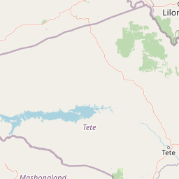
Magoe National Park landscape and geographic character
The terrain of Magoe National Park consists primarily of savanna landscapes characteristic of western Mozambique, with the northern boundary defined by the extensive waters of Cahora Bassa Dam. The region features relatively flat to undulating terrain with scattered woodland vegetation and grass-covered plains. The proximity to one of Africa's largest reservoirs creates a distinctive landscape where terrestrial ecosystems meet large inland water environments. The park's position in the Zambezi River basin contributes to the ecological character of the area, with the dam's influence extending across the surrounding terrain and influencing vegetation patterns and wildlife distribution.
Magoe National Park conservation status and protection priorities
Magoe National Park represents an important component of Mozambique's expanding protected area network. The park's designation in 2013 brought formal legal protection to savanna ecosystems in the Tete Province region. Conservation of this area supports broader regional efforts to protect biodiversity in western Mozambique, a region that contains important wildlife habitats and migratory corridors. The transition from the community-based Tchuma Tchato model to national park status provided enhanced legal frameworks for protecting wildlife populations and managing natural resources. The park contributes to Mozambique's commitments under regional biodiversity conservation initiatives and supports the country's approach to integrating community conservation with formal protected area management.
Top sights and standout views in Magoe National Park
The park's defining characteristic is its shoreline position along Cahora Bassa, providing visitors with views of one of Africa's most impressive reservoirs while exploring protected savanna landscapes. As one of Mozambique's newer national parks, Magoe represents the country's ongoing investment in conservation and eco-tourism development in the Zambezi basin region. The park offers opportunities to experience western Mozambique's distinctive combination of aquatic and terrestrial environments within a protected setting.