

Mori Atlas logo
National parkMakgadikgadi Pans National Park

Discover the mapped boundaries and regional context of this significant national park in Southern Africa.

Makgadikgadi Pans National Park: Botswana's Vast Protected Landscape and Geographic Atlas Entry

Makgadikgadi Pans National Park represents a key protected area within Botswana's expansive geography, offering a unique entry point for atlas-based discovery. This national park serves as a vital component of the region's mapped landscapes, highlighting its significant protected land status. Users can explore the park's geographic identity and its place within the broader context of Botswana, a landlocked nation largely shaped by the Kalahari Desert.

salt pansKalahariwetlandsbirdwatchingseasonal wildlifesafari

Makgadikgadi Pans National Park

National park

Park overview

Structured park overview, official facts, and landscape profile for Makgadikgadi Pans National Park

Makgadikgadi Pans National Park park facts, protected area profile, and essential visitor context

Review the core facts for Makgadikgadi Pans National Park, including designation, size, terrain, visitor scale, habitats, and operating context in one park-focused overview.

About Makgadikgadi Pans National Park

Makgadikgadi Pans National Park occupies a portion of the Makgadikgadi complex, a geological wonder in the heart of Botswana's Kalahari Basin. The salt pans extend across an area of approximately 12,000 square kilometers, though only a portion falls within the national park boundaries. This immense flat landscape formed over millions of years as ancient Lake Makgadikgadi, one of the largest lakes in Africa's history, gradually evaporated leaving behind deposits of salt and other minerals. The resulting terrain presents an almost lunar quality, with vast white expanses that shimmer in the heat and crack into geometric patterns as the surface dries. The park provides access to this remarkable landscape while protecting the surrounding Kalahari ecosystems that sustain wildlife throughout the year. Visitors to the park experience a form of wilderness fundamentally different from Botswana's better-known wetland parks, characterized by openness, silence, and the overwhelming sense of scale that the flat horizon creates.

Quick facts and research context for Makgadikgadi Pans National Park

Makgadikgadi Pans National Park protects a portion of the Makgadikgadi salt pan complex in Botswana's Central District. The pans are among the largest in the world, formed from the evaporation of ancient Lake Makgadikgadi. The landscape is characterized by vast, flat salt-crusted surfaces surrounded by Kalahari thornveld and grasslands. The park supports seasonal wildlife concentrations, particularly during the wet summer months when migratory birds and grazers move into the area. The region holds significant archaeological importance with Stone Age sites found throughout the pans.

Protection and recognition

Analyzing terrestrial boundaries, conservation frameworks, and management status.

Makgadikgadi Pans National Park Protection Status and Designation Details

Explorers can analyze the documented terrestrial conservation framework and official designation history established for Makgadikgadi Pans National Park. Verified geographic records provide essential context regarding official protection boundaries and regional land management to support structured research.

Protection details

Protection scope
Terrestrial
Park context

Deeper park guide and search-rich context for Makgadikgadi Pans National Park

Makgadikgadi Pans National Park history, landscape, wildlife, and travel context

Explore Makgadikgadi Pans National Park through its history, landscape character, ecosystems, wildlife, conservation priorities, cultural context, and seasonal travel timing in a structured park guide built for atlas discovery and search intent.

Why Makgadikgadi Pans National Park stands out

The park is renowned for its extraordinary salt pan landscape, which ranks among the largest exposed salt flats on Earth. During the wet season, the pans transform into shallow wetlands that host spectacular flamingo colonies and support large herds of zebra and wildebeest migrating from the adjacent Nata Bird Sanctuary. The stark contrast between the blinding white salt surface and the surrounding green grasslands creates one of Africa's most visually striking landscapes. The area also holds profound archaeological significance as the site of ancient human settlements and paleontological discoveries related to early Homo sapiens occupation.

Makgadikgadi Pans National Park history and protected-area timeline

The Makgadikgadi region has held significance for human populations for tens of thousands of years, with archaeological evidence indicating continuous occupation by Stone Age peoples who left behind stone tools, pottery fragments, and other artifacts across the pan surfaces. The ancient lake system supported thriving communities of early humans who exploited the rich fish and wildlife resources available in this now-arid landscape. The formal protection of the area as a national park came later in Botswana's conservation history, reflecting the government's recognition of the region's unique geological and ecological value. The park was established to protect both the salt pan landscape itself and the seasonal wildlife concentrations that make the area biologically significant despite its harsh conditions.

Makgadikgadi Pans National Park landscape and geographic character

The defining feature of Makgadikgadi Pans National Park is the vast, almost perfectly flat salt crust that stretches to the horizon in every direction during the dry season. The pan surface is typically white or pale gray, with a cracked texture resembling dried mud but composed largely of sodium chloride and other salts. Around the pan edges, the landscape transitions into Kalahari thornveld dominated by Acacia species, grasslands, and occasional rocky outcrops. The surrounding sandveld consists of ancient wind-blown dunes that have been stabilized by vegetation, creating a gently undulating terrain that contrasts with the absolute flatness of the pan surface itself. The horizon line is a defining characteristic of the landscape, with the only vertical relief provided by occasional isolated islands of vegetation and the distant tree line.

Makgadikgadi Pans National Park ecosystems, habitats, and plant life

TheMakgadikgadi ecosystem supports a remarkable range of habitats despite the challenging semi-arid conditions. The pan surfaces themselves are extremely harsh environments, but the surrounding sandveld supports grasslands, thorn woodland, and shrubland that provide habitat for diverse wildlife. During the wet season, typically from November to April, rainfall creates shallow ephemeral lakes on the pan surface that attract enormous concentrations of waterfowl and provide critical grazing for migratory ungulates. The seasonal nature of water availability shapes all aspects of the ecosystem, with wildlife movements closely tied to the rainfall patterns. The vegetation patterns reflect the underlying geology and soil conditions, with different plant communities occurring on the saline pan margins versus the surrounding sand soils.

Makgadikgadi Pans National Park wildlife and species highlights

The wildlife of Makgadikgadi pans National Park is characterized by dramatic seasonal fluctuations tied to the availability of water. During the wet season, the shallow flooding of the pans creates ideal conditions for massive flocks of flamingos, particularly the greater flamingo, which breed in the area in enormous numbers. The shallow waters also support other waterfowl including pelicans, ducks, and waders. Large herds of zebra and wildebeest migrate into the area from surrounding landscapes, attracted to the fresh grazing that emerges as the rains arrive. Antelope species including springbok, gemsbok, and red hartebeest are resident throughout the year, while predators such as lions, cheetahs, and hyenas follow the migratory prey. The birdlife is particularly notable, with the flamingo colonies representing one of the most spectacular avian gatherings in Africa.

Makgadikgadi Pans National Park conservation status and protection priorities

Makgadikgadi Pans National Park represents an important conservation priority as one of the few protected areas preserving the unique Kalahari salt pan ecosystem. The park protects both the geological heritage of the ancient lake system and the seasonal habitat that supports internationally significant bird populations. The Makgadikgadi complex, including the national park and adjacent Nata Bird Sanctuary, forms a network of protected areas that together provide crucial refuge for waterbirds during the wet season. Conservation challenges in the region include managing the tension between wildlife conservation and the traditional pastoral activities of local communities, as well as addressing the impacts of climate variability on the delicate water balance that sustains the seasonal ecosystem.

Makgadikgadi Pans National Park cultural meaning and human context

The Makgadikgadi region has been inhabited by humans for tens of thousands of years, with the salt pans and surrounding landscapes holding deep cultural significance for the indigenous peoples of Botswana. Stone Age archaeological sites are found throughout the area, representing some of the oldest evidence of human occupation in southern Africa. The ancient lake system would have provided abundant resources for early human communities, supporting fishing, hunting, and gathering economies that sustained populations in this otherwise challenging environment. Modern communities in the surrounding area continue traditional pastoral and agricultural activities, with the seasonal nature of the landscape influencing cultural practices and land use patterns.

Top sights and standout views in Makgadikgadi Pans National Park

The extraordinary scale of the salt pan landscape creates one of Africa's most distinctive wilderness experiences, with views extending unbroken to the horizon across the white expanse. The seasonal transformation during the wet season, when the pans fill with shallow water and become alive with thousands of flamingos and other waterfowl, represents a natural spectacle of global significance. The archaeological heritage of the region provides a window into prehistoric human life and the evolution of the landscape over millions of years. The contrast between the stark, empty pans and the green grasslands and wildlife that appear with the rains creates a profound sense of the seasonal rhythms that govern this corner of the Kalahari.

Best time to visit Makgadikgadi Pans National Park

The optimal time to visit Makgadikgadi Pans National Park is during the wet season, typically from November through April, when rainfall transforms the landscape and attracts wildlife concentrations. The wet season brings the spectacular flamingo gatherings, with tens of thousands of birds breeding and feeding in the shallow waters. The surrounding grasslands turn green, providing excellent wildlife viewing as zebra, wildebeest, and other grazers move into the area. The dry season, from May to October, offers a different experience characterized by stark, arid conditions and more limited wildlife viewing opportunities, though the vast empty pans have their own stark beauty. Temperatures are extreme in both seasons, with very hot conditions in the wet season and cool nights during the dry winter months.

Monthly climate preview

Trace long-term average temperature and precipitation rhythms across the protected landscape

Makgadikgadi Pans National Park Climate and Monthly Temperature Normals

Makgadikgadi Pans National Park records measured annual climate rhythms featuring distinct temperature swings and multi-monthly precipitation patterns. Analyzing the complete monthly profile provides deeper insight into long-term environmental averages across the protected area.
Annual mean24 °C
16 °C28 °C
Jan28°
Feb27°
Mar26°
Apr24°
May20°
Jun17°
Jul16°
Aug19°
Sep24°
Oct27°
Nov28°
Dec28°
Warmest month
November

28.1 °C

Coolest month
July

16.1 °C

Wettest month
January

3.1 mm/day

Driest month
August

0 mm/day

Park location guide

Geography guide, regional context, and park location map for Makgadikgadi Pans National Park

Makgadikgadi Pans National Park park geography, regions, and map view in Botswana

Understand where Makgadikgadi Pans National Park sits in Botswana through a broader geographic reading of the surrounding landscape, nearby location context, and its mapped position within the national park landscape.

How Makgadikgadi Pans National Park fits into Botswana

Botswana is a landlocked nation in Southern Africa with approximately 2.4 million residents across 581,730 km² of territory. About 70% of the country lies within the Kalahari Desert. Botswana gained independence in 1966 and operates as a parliamentary republic with President Duma Boko as head of state. The economy is driven by diamond mining and tourism, with the country maintaining one of Africa's higher human development indices.

Wider geography shaping Makgadikgadi Pans National Park in Botswana

Botswana is a landlocked country in Southern Africa, bordered by South Africa to the south and southeast, Namibia to the west and north, Zambia to the north, and Zimbabwe to the northeast. The terrain is predominantly flat, with approximately 70% of the territory comprising the Kalahari Desert. The country lies at roughly 24°39.5′S 25°54.5′E.

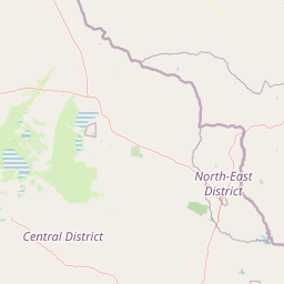
Map view of Makgadikgadi Pans National Park

Use this park location map to pinpoint Makgadikgadi Pans National Park in Botswana, understand its exact geographic position, and read its mapped placement within the surrounding landscape more clearly.

Pigeon | © OpenStreetMap contributors
Park atlas

Map the regional protected landscapes surrounding Makgadikgadi Pans and the Kalahari.

Explore Other National Parks and Protected Areas Near Makgadikgadi Pans National Park

Explore additional national parks and protected areas across Botswana, tracing the distinct Kalahari ecosystems and vast salt pan landscapes that define the region. This broader geographic context allows for detailed comparison of diverse conservation efforts and terrain features adjacent to Makgadikgadi Pans National Park.
National parkBotswana
About 70 km away#1 closest

Northwest

Nxai Pan National Park: Botswana's Iconic Baobab Forests and Salt Pan Landscape

Explore mapped boundaries and unique regional geography.

Nxai Pan National Park offers a compelling glimpse into Botswana's unique semi-arid ecosystems, characterized by the expansive, salt-crusted Nxai Pan itself and the iconic Baines Baobabs dotting its edges. As a protected national park, it represents a significant conservation landscape within the Kalahari Desert region. Understanding its geography involves appreciating the stark visual contrasts, seasonal wetland transformations, and the vast openness of the salt pan environment.

Area
2,578 km²
Established
1992
IUCN
Ib
Relief
Lowland
National parkMatabeleland North
About 163 km away#2 closest

Northeast

Hwange National Park: Explore its Mapped Boundaries and Protected Landscape in Matabeleland North

National Park with distinct geographic and landscape context.

Gain a structured understanding of Hwange National Park, a designated national park within the Matabeleland North region of Zimbabwe. This detailed entry focuses on its precise mapped boundaries and its contribution to the regional geography. Ideal for atlas-based discovery, it highlights Hwange National Park as a key protected landscape for understanding conservation and natural terrain distribution.

Area
14,651 km²
Established
1961
IUCN
II
Relief
Lowland
National parkBotswana
About 206 km away#3 closest

North

Chobe National Park: Botswana National Park Atlas and Mapped Landscape Explorer

Discover Botswana's diverse protected areas and unique savanna wetlands.

Chobe National Park represents a cornerstone of protected land discovery in Botswana, offering an unparalleled glimpse into a landscape shaped by dynamic water systems and iconic wildlife. This national park is not merely a destination; it is a vital ecosystem supporting vast elephant populations and showcasing a remarkable variety of terrain from riverine floodplains to savanna marshes. Understanding Chobe National Park through its mapped boundaries and regional geographic context reveals its significance as a protected natural area with diverse habitats supporting critical conservation efforts.

Area
11,700 km²
Established
1967
IUCN
II
Relief
Mixed relief
National parkZimbabwe
About 272 km away#4 closest

North

Kazuma Pan National Park: Zimbabwe National Park Atlas and Protected Landscape Exploration

Unique plains landscape with reliable dry-season wildlife viewing.

Kazuma Pan National Park offers a rare glimpse into Zimbabwe's expansive grassy plains and vital pans, creating a unique protected landscape. This national park is critical for understanding regional wildlife migrations and the geographic context of conservation areas in northwestern Zimbabwe, providing an essential entry point for atlas-based exploration of its terrain and ecological significance.

Area
313 km²
Established
1975
IUCN
II
Relief
Lowland
National parkMatobo District
About 315 km away#5 closest

East

Matobo National Park: Detailed Protected Area and Landscape Geography in Matobo District

Explore its mapped boundaries and regional context.

Delve into the protected landscape of Matobo National Park, a significant national park situated in Matobo District, Zimbabwe. This entry focuses on providing a structured atlas view, highlighting the park's mapped boundaries and its integration within the regional geography. Understand Matobo National Park as a distinct protected area entity, perfect for users seeking detailed geographic context and landscape insights for map-based discovery and conservation analysis.

Area
424 km²
Established
1926
IUCN
II
Relief
Mountain
National parkZimbabwe
About 315 km away#6 closest

North

Victoria Falls National Park: A Protected Landscape Within Zimbabwe's Geography

Atlas exploration of park boundaries and natural terrain.

Victoria Falls National Park is a key component of Zimbabwe's protected natural areas. This page provides structured information ideal for atlas-based exploration, detailing the park's geographic position and mapped landscape features. Understand its significance as a national park and its contribution to the region's conservation geography.

Area
23.4 km²
IUCN
II
Relief
Mixed relief
Climate
Tropical
National parkNamibia
About 319 km away#7 closest

Northwest

Nkasa Rupara National Park: A Protected Landscape within Namibia's Geography

Explore the mapped protected area and its regional landscape context.

Nkasa Rupara National Park represents a distinct protected landscape within Namibia. This entry provides detailed geographic context, focusing on the park's mapped boundaries and its role as a national park. Understand how this protected area contributes to the broader regional geography, offering a focal point for atlas-based exploration of Namibia's natural lands.

Area
320 km²
Established
1990
IUCN
II
Relief
Lowland
National parkHwange District
About 320 km away#8 closest

North

Zambezi National Park: National Park within Hwange District's Geographic Landscape

Explore mapped boundaries and protected area context.

Delve into Zambezi National Park, a designated national park situated in Hwange District. This entry provides foundational geographic and landscape context, highlighting the park's protected status and its position within the regional terrain. Understand the atlas significance and mapped features of this conservation landscape for informed discovery.

Area
560 km²
Established
1979
Relief
Lowland
Climate
Subtropical

Common questions about visiting, size, designation, and location context for Makgadikgadi Pans National Park

Makgadikgadi Pans National Park FAQs for park facts, access, geography, and protected area context

Find quick answers about Makgadikgadi Pans National Park, including protected-area facts, park geography, trail and visitor context, and how the park fits into its surrounding country and regional landscape.
MoriAtlas Explorer

Continue Your Protected Areas Search Across the Global Atlas

Deepen your exploration by continuing the structured search for national parks and protected areas worldwide. Utilize the comprehensive filtering capabilities to compare different conservation landscapes and refine your understanding of global park geography. Discover more about the distribution and characteristics of protected natural areas.

Global natural geography
