

Mori Atlas logo
National parkManglot National Park

Understand the mapped boundaries and natural terrain of this national park.

Manglot National Park: Pakistan's Protected Landscape and Regional Geography in Khyber Pakhtunkhwa

Manglot National Park stands as a significant protected area within the Khyber Pakhtunkhwa region of Pakistan. This page offers an atlas-oriented view, detailing the park's mapped boundaries and its place within the surrounding natural geography. Explore the fundamental protected landscape characteristics and regional context that define Manglot National Park, providing a foundation for structured geographic discovery.

scrub forestKhyber Pakhtunkhwawildlife sanctuaryleopard habitatchinkaraprotected area

Manglot National Park

National park

Park overview

Structured park overview, official facts, and landscape profile for Manglot National Park

Manglot National Park park facts, protected area profile, and essential visitor context

Review the core facts for Manglot National Park, including designation, size, terrain, visitor scale, habitats, and operating context in one park-focused overview.

About Manglot National Park

Manglot National Park sits in the northwestern part of Pakistan, within the ancient hills and river plains that characterize the Nowshera district. The protected area was formally established in 1990 to preserve a tract of scrub forest that had otherwise faced shrinking due to agricultural expansion and human settlement. The park's location near the Indus River places it at the intersection of multiple habitat types, with the scrub-covered hills rising from the more fertile river corridor. This geographical position has made the area historically significant as a corridor for wildlife movement between the Himalayan foothills and the plains of Punjab province. The park remains an important ecological island in a landscape that has seen substantial transformation over the past several decades.

Quick facts and research context for Manglot National Park

Manglot National Park is located in the Nowshera district of Khyber Pakhtunkhwa province, approximately 10 kilometers from the town of Nizampur. The park was established in 1990 and covers an area of 1,756 acres, or roughly 7.11 square kilometers. The terrain combines elevated hilltops with plains areas that extend toward the Indus River floodplain. The ecosystem is characterized by scrub forest vegetation dominated by olive trees and Acacia species.

Protection and recognition

Analyzing the official terrestrial conservation boundaries and designated status of the park.

Manglot National Park Protected Area Status and Terrestrial Conservation Scope

Map-based researchers can verify the official terrestrial protection scope and documented boundary status of Manglot National Park. Accessing official designation records provides essential regional context for understanding documented land preservation efforts and localized habitat management.

Protection details

Protection scope
Terrestrial
Transboundary protection
No
Park context

Deeper park guide and search-rich context for Manglot National Park

Manglot National Park history, landscape, wildlife, and travel context

Explore Manglot National Park through its history, landscape character, ecosystems, wildlife, conservation priorities, cultural context, and seasonal travel timing in a structured park guide built for atlas discovery and search intent.

Why Manglot National Park stands out

Manglot National Park is best known for its scrub forest ecosystem, which represents a distinctive habitat type in the Khyber Pakhtunkhwa region. The park protects populations of chinkara and hog deer, two ungulate species of conservation concern in Pakistan. The area also supports a notable population of leopards, making it one of the more accessible locations in the province where this elusive predator can be encountered. The combination of dry scrub woodland with proximity to the Indus River creates a unique ecological interface that supports diverse fauna.

Manglot National Park history and protected-area timeline

Manglot National Park was established in 1990 as a protected area under Pakistani national park legislation. The creation of the park reflected growing recognition in Pakistan during the late 1980s and early 1990s of the need to preserve remaining scrub forest habitats in the country's northern and northwestern regions. Prior to formal protection, the Manglot area had served as a traditional grazing area and hunting ground, with wildlife populations facing sustained pressure from human activities. The establishment of the park provided legal protection for the area's fauna, including species such as the chinkara and leopard that had been hunted in the region. The park was designated both as a national park and a wildlife sanctuary, reflecting its dual purpose of habitat preservation and wildlife conservation.

Manglot National Park landscape and geographic character

The landscape of Manglot National Park consists of undulating terrain that combines hilltops with flat plains extending toward the Indus River. The hills within the park reach moderate elevations and support the scrub forest vegetation that defines the area's character. The plains areas near the river feature more fertile soils that support different vegetation communities. The overall topography creates a mosaic of habitats, with dry slopes covered in scrub vegetation contrasting with the more lush riparian corridor along the Indus. The landscape has a distinctly semi-arid character, with vegetation adapted to seasonal variation in rainfall and temperature.

Manglot National Park ecosystems, habitats, and plant life

The nature of Manglot National Park is defined by its scrub forest ecosystem, a habitat type that once covered much of the foothills and plains of northwestern Pakistan but has now been largely reduced to isolated patches. The park's vegetation is dominated by olive trees, which form the primary canopy species across much of the protected area. Acacia modesta is another significant tree species present in the park, while the understory includes species such as zizyphus, olea, deodonia, and monothica. This plant community supports a characteristic fauna adapted to dry woodland conditions, including both resident species and those that use the area as a seasonal corridor. The scrub forest provides critical habitat for species that cannot survive in the more intensive agricultural landscapes that have replaced similar habitats elsewhere in the region.

Manglot National Park wildlife and species highlights

Manglot National Park supports a diverse array of wildlife, with particular significance attached to its populations of ungulates and large predators. The park is home to the chinkara, a graceful gazelle species that remains widespread but has declined in many parts of its range, and the hog deer, a species that favors the more vegetated areas within the forest. The common leopard inhabits the park, representing one of the more notable conservation values of the protected area, as this species has been squeezed into increasingly marginal habitats across South Asia. Additional mammalian species include the wolf, wild boar, jackal, porcupine, and hare. The bird population includes chukar partridge, multiple partridge species, rock pigeons, doves, and various sparrow species. Reptiles including snakes and lizards are also present in the park.

Manglot National Park conservation status and protection priorities

Manglot National Park represents an important conservation asset for Khyber Pakhtunkhwa, providing protection for a scrub forest ecosystem that has become increasingly rare in the province. The park's location near the Indus River adds to its conservation significance, as the river corridor serves as a vital wildlife movement route through the region. Protection of the chinkara and hog deer populations is particularly important, as both species face habitat loss across their ranges in Pakistan. The leopard population in the park demonstrates that the area retains enough ecological integrity to support this wide-ranging predator, which requires large territories and sufficient prey populations. The park functions as a refuge in a landscape where remaining natural habitats are fragmented and under pressure.

Manglot National Park cultural meaning and human context

Manglot National Park is situated in an area with historical significance related to the Indus River valley and the ancient trade routes that passed through the Khyber Pakhtunkhwa region. The village of Nizampur, which lies near the park boundary, reflects the long human presence in this landscape. Local communities have historically used the areas surrounding the park for grazing and small-scale agriculture, practices that continue to influence the park's boundary relationships with surrounding lands. The park's establishment in 1990 represents a more recent chapter in the area's history, shifting from a landscape used primarily for extraction to one managed for conservation.

Top sights and standout views in Manglot National Park

The highlights of Manglot National Park include its accessible leopard population, which draws wildlife enthusiasts interested in observing this elusive cat in its natural habitat. The scrub forest environment offers a distinctive visual character different from the alpine and subalpine environments more commonly associated with Pakistan's northern mountains. The park provides habitat for both chinkara and hog deer, offering opportunities to observe these graceful ungulates in a protected setting. The birdlife, particularly the partridge species and the chukar, adds to the park's appeal for birdwatchers. The proximity to the Indus River adds another dimension to the park's character, with the river visible from some of the higher ground within the protected area.

Monthly climate preview

Long-term representative point measurements tracking monthly temperature and precipitation cycles

Manglot National Park Climate Normals, Annual Temperature and Precipitation Rhythm

Manglot National Park records tracked long-term monthly temperature averages and daily precipitation rates across a representative high-elevation coordinate. Opening the full profile reveals complete twelve-month climate tables for detailed environmental analysis.
Annual mean-3 °C
-16 °C10 °C
Jan-16°
Feb-14°
Mar-9°
Apr-3°
May
Jun
Jul10°
Aug10°
Sep
Oct-1°
Nov-8°
Dec-13°
Warmest month
July

10.2 °C

Coolest month
January

-15.5 °C

Wettest month
April

1.1 mm/day

Driest month
October

0.4 mm/day

Park location guide

Geography guide, regional context, and park location map for Manglot National Park

Manglot National Park park geography, regions, and map view in Pakistan

Understand where Manglot National Park sits in Pakistan through a broader geographic reading of the surrounding landscape, nearby location context, and its mapped position within the national park landscape.

How Manglot National Park fits into Pakistan

Pakistan, officially the Islamic Republic of Pakistan, is a federal parliamentary Islamic republic in South Asia. It is the fifth-most populous country and the 33rd-largest by area. The country gained independence from British India in 1947 and has a diverse history spanning ancient civilizations including Mehrgarh and the Indus Valley Civilisation. Pakistan shares maritime borders with Oman and is bounded by the Arabian Sea, Gulf of Oman, and several neighboring countries.

Wider geography shaping Manglot National Park in Pakistan

Pakistan is located in South Asia, bordered by the Arabian Sea to the south, the Gulf of Oman to the southwest, and shares land borders with India to the east, Afghanistan to the west, Iran to the southwest, and China to the northeast. The country also shares a maritime border with Oman in the Gulf of Oman. The Wakhan Corridor in Afghanistan separates Pakistan from Tajikistan in the northwest.

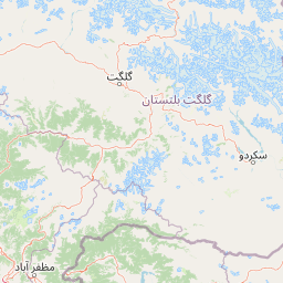
Map view of Manglot National Park

Use this park location map to pinpoint Manglot National Park in Pakistan, understand its exact geographic position, and read its mapped placement within the surrounding landscape more clearly.

Pigeon | © OpenStreetMap contributors

Location context for Manglot National Park

Khyber Pakhtunkhwa
Park atlas

Discover the broader park geography of Khyber Pakhtunkhwa's protected landscapes and the Indus River basin.

Explore Other National Parks and Protected Areas Near Manglot National Park

Continue your journey from Manglot National Park to browse other protected areas within Pakistan's Khyber Pakhtunkhwa region and across the wider Indus basin. Compare diverse scrub forest ecosystems, riverine habitats, and critical wildlife populations found in these geographically connected conservation landscapes.
National parkKhyber Pakhtunkhwa
About 66 km away#1 closest

North

Broghil Valley National Park: High-Altitude Protected Landscape and Alpine Wilderness in Pakistan

Explore mapped terrain with glacial lakes and diverse mountain ecosystems.

Broghil Valley National Park, a national park in Pakistan's Khyber Pakhtunkhwa province, is a vast high-altitude wilderness defined by its dramatic glacial topography, numerous freshwater lakes, and vital peatland ecosystems. Situated near the Afghanistan border, this protected area offers an exceptional landscape for exploring remote mountain biodiversity and understanding the geography of Pakistan's northern frontier. Its unique terrain provides critical habitat within the Central Asian mountain range.

Area
1,348 km²
Established
2010
IUCN
II
Relief
Mountain
National parkPakistan
About 75 km away#2 closest

West

Hundrap-Shandur National Park: Pakistan National Park Atlas and Protected Landscape

Discover mapped boundaries and regional geography for this park.

Hundrap-Shandur National Park is a protected area in Pakistan, designated as a national park. Its geographic identity and mapped landscape context are crucial for understanding the country's conservation network. This MoriAtlas entry provides detailed information about the park's spatial representation, regional setting, and its significance as a mapped natural landscape within Pakistan's atlas.

IUCN
II
National parkAfghanistan
About 120 km away#3 closest

Northwest

Wakhan National Park: Afghanistan's Protected Landscape for Geographic Atlas Exploration

Mapped boundaries and regional terrain context.

Wakhan National Park is a designated national park in Afghanistan, offering critical insights into the country's rugged, mountainous geography. This page provides an atlas-level view of its protected landscape, detailing its geographic scope and mapped boundaries. Explore Wakhan National Park to understand its role within the broader regional context of Central and South Asia's natural terrain.

Area
10,910.1 km²
Established
2014
IUCN
II
Relief
Mountain
Wildlife reserveGilgit-Baltistan
About 130 km away#4 closest

Southeast

Astore Wildlife Sanctuary: Protected Alpine and Mountain Landscapes in Gilgit-Baltistan

High-altitude conservation area between Nanga Parbat and Deosai

Astore Wildlife Sanctuary encompasses over 400 square kilometers of diverse mountain terrain in Pakistan. Spanning from temperate river valleys to glaciated alpine peaks, the sanctuary safeguards critical habitats for threatened species like the Astor markhor and the Himalayan brown bear. Use this geographic atlas data to understand its unique position within the western Karakoram borderlands.

Area
414.72 km²
Established
1975
Relief
Mountain
Climate
Alpine
National parkGilgit-Baltistan
About 139 km away#5 closest

Northeast

Qurumbar National Park: Pakistan's High-Altitude Protected Landscape and Geographic Atlas Point

Explore mapped alpine terrain, glacial features, and vital wildlife corridors.

Qurumbar National Park, situated in the rugged terrain of Gilgit-Baltistan, Pakistan, offers an unparalleled glimpse into a high-altitude protected landscape. This national park is defined by its dramatic alpine valleys, glacial features, and significant ecological value. As a key atlas point, it showcases the convergence of major Asian mountain systems and provides critical habitat for iconic mountain wildlife within its mapped boundaries.

Area
738 km²
Established
2011
IUCN
II
Relief
Mountain
National parkKhyber Pakhtunkhwa
About 141 km away#6 closest

South

Saiful Muluk National Park: Mapped Protected Landscape and Alpine Terrain in Pakistan

Discover the geography and protected boundaries of this Himalayan national park.

Saiful Muluk National Park in Khyber Pakhtunkhwa, Pakistan, is a key protected area characterized by its stunning alpine lake and dramatic Himalayan topography. This entry details the park's geographic scope, mapped landscape features, and its role as a critical national park. Understand the unique subalpine forests and meadow habitats that define this mountainous region and its protected status.

Area
880 km²
Established
2003
IUCN
II
Relief
Mountain
National parkPakistan
About 142 km away#7 closest

Southeast

Lulusar-Dudipatsar National Park: Pakistan's Dramatic Western Himalayan Protected Area

Explore alpine lakes, mountain scenery, and protected landscape geography.

Lulusar-Dudipatsar National Park stands as a remarkable protected landscape within Pakistan's Western Himalayas. The park's geography is defined by towering peaks and a series of pristine glacial lakes, including the iconic Dudipatsar and Lulusar lakes. Users can explore its mapped terrain and understand its significance as a high-altitude ecosystem and a key component of Pakistan's protected areas network.

Established
2003
IUCN
II
Relief
Mountain
Climate
Alpine
National parkAzad Kashmir
About 149 km away#8 closest

Southeast

Ghamot National Park: Pakistan National Park Atlas and Protected Landscape

Explore mapped boundaries and regional geography in Azad Kashmir.

Ghamot National Park represents a cornerstone for protected area exploration in Pakistan, situated within the dramatic mountainous terrain of Azad Kashmir. As a national park, it is recognized for its critical function as a wildlife corridor, especially for the survival of the Himalayan Brown Bear, and harbors diverse avian populations. This page offers detailed insight into its geographic context and its significance within a broader regional conservation strategy, providing rich data for atlas-based discovery.

Established
2004
IUCN
II
Relief
Mountain
Access
Remote access

Common questions about visiting, size, designation, and location context for Manglot National Park

Manglot National Park FAQs for park facts, access, geography, and protected area context

Find quick answers about Manglot National Park, including protected-area facts, park geography, trail and visitor context, and how the park fits into its surrounding country and regional landscape.
MoriAtlas Explorer

Continue Your Protected Areas Search Across the Global Atlas

Deepen your exploration by continuing the structured search for national parks and protected areas worldwide. Utilize the comprehensive filtering capabilities to compare different conservation landscapes and refine your understanding of global park geography. Discover more about the distribution and characteristics of protected natural areas.

Global natural geography