Mori Atlas logo
National parkMarakele National Park

Trace the mapped boundaries and geographic context of this distinct protected area.

Marakele National Park: A Protected National Park Landscape in Limpopo Province

Marakele National Park stands as a significant protected national park within the Limpopo Province of South Africa. This page offers an atlas-driven exploration of its protected landscape, focusing on its geographic scope and mapped boundaries. Understand Marakele National Park not just as a conservation area, but as a key element within the regional geography, providing context for mapped terrain and natural landscape discovery.

Big FiveCape VulturesWaterberg BiosphereBushveldSouth African National ParksSafari Wildlife

Marakele National Park

National park

Park overview

Structured park overview, official facts, and landscape profile for Marakele National Park

Marakele National Park park facts, protected area profile, and essential visitor context
Review the core facts for Marakele National Park, including designation, size, terrain, visitor scale, habitats, and operating context in one park-focused overview.

About Marakele National Park

Marakele National Park occupies a significant position within South Africa's protected area network, representing the biodiversity-rich Waterberg region in Limpopo Province. The park's terrain is characterized by the imposing Waterberg massif, a sandstone mountain formation that creates a dramatic eastern boundary and offers panoramic views from its elevated passes. The MATLABas River traverses the park, providing crucial water resources for wildlife and supporting riparian ecosystems along its banks. Marakele's ecological significance extends beyond its wildlife populations to include unique vegetation communities that blend elements of fynbos and bushveld ecosystems, creating a transitional zone of exceptional botanical diversity. The park's location within the Waterberg Biosphere places it within a region recognized internationally for its conservation value and ecological importance.

Quick facts and research context for Marakele National Park

Marakele National Park spans 670 square kilometers in the Waterberg region of Limpopo Province, South Africa. The park was established in 1994 as Kransberg National Park and renamed shortly after to honor the naturalist Eugène Marais, who once lived in the area. It forms part of the Waterberg Biosphere, a UNESCO-recognized biosphere reserve. The park features the Matlabas River running through its center, the dramatic Waterberg massif with a tarred mountain pass leading to its summit, and the ecologically significant Apiesrivierpoort Forest. The park is managed by South African National Parks.

Park context

Deeper park guide and search-rich context for Marakele National Park

Marakele National Park history, landscape, wildlife, and travel context
Explore Marakele National Park through its history, landscape character, ecosystems, wildlife, conservation priorities, cultural context, and seasonal travel timing in a structured park guide built for atlas discovery and search intent.

Why Marakele National Park stands out

Marakele is best known for housing the world's largest colony of Cape vultures, with approximately 800 breeding pairs nesting in the park's cliffs and rocky outcrops. The park has also achieved notable success in establishing all of Africa's big five game species, having reintroduced disease-free buffalo in 2013 to complete the complement of lion, leopard, elephant, and both black and white rhinoceros. The dramatic backdrop of the Waterberg massif, rising steeply from the bushveld plains, provides one of the most visually striking landscapes in South Africa's protected areas.

Marakele National Park history and protected-area timeline

The area now comprising Marakele National Park has a rich human history, having been home to several iron-age settlements that remain unexcavated and closed to public viewing. The park is named in honor of Eugène Marais, the renowned South African naturalist who lived in the region and made significant contributions to the understanding of local wildlife. Marakele was established in 1994 under its original name of Kransberg National Park, beginning with the purchase of 150 square kilometers of land. The park was subsequently renamed to reflect its broader identity and connection to the Marais legacy. By 1999, the park had expanded to its current extent of 670 square kilometers through additional land acquisitions, creating a substantial protected wilderness area within the Waterberg region.

Marakele National Park landscape and geographic character

The landscape of Marakele National Park is dominated by the spectacular Waterberg massif, a sandstone mountain range that rises sharply from the surrounding bushveld plains. A tarred mountain pass provides vehicle access to the summit, offering visitors sweeping views across the protected area and the broader Waterberg landscape. The park contains several dams, including the Apiesrivierpoort Dam (also known as Tlopi Dam) and the Bontle Dam, which create wetland habitats and provide viewing points for wildlife. The Bollonoto viewing point offers additional opportunities to experience the park's varied terrain. Rocky outcrops and cliff faces throughout the park provide nesting habitat for the resident Cape vulture population, while the valley floors support more densely vegetated areas.

Marakele National Park ecosystems, habitats, and plant life

Marakele contains a remarkable diversity of vegetation types, reflecting its position within a transition zone between different ecological communities. Approximately half the park is covered by Waterberg Moist Bushveld, while 42 percent supports Mixed Bushveld vegetation. The small but ecologically significant Apiesrivierpoort Forest covers eight hectares along the southeastern bank of the Apiesrivierpoort Dam, containing species such as red ivory and African olive. The park also supports several endemic and rare plant species, including the Waterberg agapanthus, which is found only in this region, and the endangered cycad Encephalartos eugene-maraisii. These botanical values contribute to the park's importance within South Africa's conservation estate.

Marakele National Park wildlife and species highlights

Marakele National Park supports an impressive array of wildlife, including all of Africa's big five game species. The park is home to African bush elephant, lion, African leopard, and both black and white rhinoceros, with the final member of this group, the African buffalo, having been reintroduced in 2013 through the release of 20 disease-free animals. Sixteen species of antelope inhabit the park, including impala, kudu, sable, and waterbuck. The park is particularly significant for its birdlife, with over 250 species recorded including the largest colony of Cape vultures in the world. Additional predators include brown hyena, while primates such as Chacma baboon and vervet monkey are also present.

Marakele National Park conservation status and protection priorities

Marakele National Park plays a vital role in the conservation of South Africa's wildlife heritage, particularly within the Waterberg Biosphere region. The successful reintroduction of the big five, culminating with the buffalo translocation in 2013, demonstrates the park's capacity to support viable populations of flagship species. The protection of the world's largest Cape vulture colony represents a significant global conservation contribution, as this species faces mounting pressures across its range. The park's location within the Waterberg Biosphere connects it to broader conservation initiatives aimed at preserving the region's biodiversity and ecological processes.

Marakele National Park cultural meaning and human context

The region encompassing Marakele National Park has been inhabited by humans for centuries, with iron-age settlements having existed in the area though these archaeological sites remain closed to public access. The park is named after Eugène Marais, a pioneering South African naturalist whose observations of wildlife in the Waterberg region contributed to early scientific understanding of African ecology. Marais's works on antlion behavior and other natural history subjects remain influential, and his connection to the area provides an important cultural link between the landscape and the development of South African environmental awareness.

Top sights and standout views in Marakele National Park

The Waterberg massif provides a dramatic backdrop for wildlife viewing, with a tarred mountain pass offering access to spectacular summit vistas. The Tlopi Tented Camp sits on the banks of the Apiesrivierpoort Dam, providing opportunities to observe wildlife at the water's edge. The Cape vulture colony represents a globally significant bird population, while the big five game species offer classic African safari experiences. The Apiesrivierpoort Forest provides a contrasting environment of dense woodland within the broader savanna landscape.

Best time to visit Marakele National Park

The dry winter months from May to September offer optimal conditions for wildlife viewing in Marakele, as vegetation is less dense and animals concentrate around water sources. The summer months from October to April bring lush green scenery and excellent birdwatching opportunities, particularly for observing migratory species. The park can be explored year-round, though visitors should be aware that some internal roads require four-wheel drive vehicles, especially after rainfall.
Park location guide

Geography guide, regional context, and park location map for Marakele National Park

Marakele National Park park geography, regions, and map view in South Africa
Understand where Marakele National Park sits in South Africa through a broader geographic reading of the surrounding landscape, nearby location context, and its mapped position within the national park landscape.

How Marakele National Park fits into South Africa

South Africa is the southernmost country in Africa, spanning 1.22 million km² with a population of over 63 million. The country operates with three capital cities, Pretoria (executive), Cape Town (legislative), and Bloemfontein (judicial), and is renowned for its biodiversity, national parks, and multicultural society.

Wider geography shaping Marakele National Park in South Africa

South Africa occupies the southernmost region of Africa, with coastline along both the Atlantic Ocean to the west and the Indian Ocean to the east. The interior features elevated plateaus including the Highveld, with the Drakensberg escarpment marking the eastern highlands. The country shares borders with Namibia, Botswana, Zimbabwe, Mozambique, Eswatini, and Lesotho.

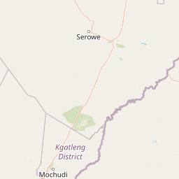
Map view of Marakele National Park

Use this park location map to pinpoint Marakele National Park in South Africa, understand its exact geographic position, and read its mapped placement within the surrounding landscape more clearly.

Pigeon | © OpenStreetMap contributors

Location context for Marakele National Park

Limpopo Province
Park atlas

Expand your park atlas view from Marakele National Park to neighboring conservation areas and diverse terrains of the Waterberg Biosphere.

Marakele National Park: Discover Other Protected Areas and National Parks in the Waterberg Region
Continue your journey of geographic discovery by browsing other national parks and protected areas situated near Marakele National Park in South Africa's Limpopo Province. Compare diverse landscapes, conservation efforts, and unique wildlife habitats across the broader Waterberg region and beyond, enhancing your understanding of connected protected-area geography.
Watercolor illustration of a savanna landscape with scattered trees and rock formations
National parkLimpopo

Mapungubwe National Park: National Park with Rich Iron Age Archaeology and Savanna Landscapes

Explore Limpopo's unique protected area at the three-nation border.

Mapungubwe National Park is a vital protected area in South Africa's Limpopo region, renowned for its dual significance as a major archaeological site and a diverse natural landscape. This national park protects a significant portion of savanna ecosystems, including unique riparian forests and mopane woodlands, surrounding the historic Mapungubwe Hill. As part of the Greater Mapungubwe Transfrontier Conservation Area, it plays a crucial role in regional conservation, offering a distinct geographic perspective at the confluence of South Africa, Botswana, and Zimbabwe, and serving as a focal point for atlas-based discovery of protected lands.

Area
280 km²
Established
1998
IUCN
II
Relief
Lowland
Protected areaSouth Africa

Greater Mapungubwe Transfrontier Conservation Area: A Transboundary Protected Landscape in South Africa

Mapped savanna ecosystems and rich cultural heritage at the Limpopo River confluence.

The Greater Mapungubwe Transfrontier Conservation Area, situated in South Africa, stands as a remarkable example of collaborative conservation across national borders. This protected area protects diverse savanna landscapes, particularly around the confluence of the Shashe and Limpopo Rivers, and holds immense cultural value as home to the Mapungubwe Cultural Landscape, a UNESCO World Heritage Site. By examining its mapped geography and protected area status, users gain insight into the ecological corridors vital for wildlife and the ancient archaeological heritage preserved within this significant transfrontier initiative.

Area
4,872 km²
Established
2009
IUCN
VI
Relief
Upland
National parkSouth Africa

Kruger National Park: South Africa's Iconic National Park for Geographic Discovery

Explore savanna landscapes and mapped protected area boundaries.

Kruger National Park serves as a paramount example of a protected landscape, offering a rich tapestry of savanna ecosystems and varied terrain across South Africa's Lowveld. This canonical entry details its vast geographic scope, approximately 19,623 square kilometres, and its status as the nation's first national park. Understand the park's environmental context, from the Lebombo Mountains to the Limpopo River, and its integral role within larger transfrontier conservation initiatives, providing critical insight for atlas-based geographic exploration.

Area
19,623 km²
Established
1926
IUCN
II
Visitors
1.7M annual
National parkMatobo District

Matobo National Park: Detailed Protected Area and Landscape Geography in Matobo District

Explore its mapped boundaries and regional context.

Delve into the protected landscape of Matobo National Park, a significant national park situated in Matobo District, Zimbabwe. This entry focuses on providing a structured atlas view, highlighting the park's mapped boundaries and its integration within the regional geography. Understand Matobo National Park as a distinct protected area entity, perfect for users seeking detailed geographic context and landscape insights for map-based discovery and conservation analysis.

Area
424 km²
Established
1926
IUCN
II
Relief
Mountain
National parkFree State

Golden Gate Highlands National Park: Protected Area Atlas & Geographic Exploration

Mapping the natural terrain and boundaries of this national park.

Understand the geographic scope and protected landscape of Golden Gate Highlands National Park. This detail page provides an atlas-informed perspective on its natural terrain, mapped boundaries, and regional context within South Africa's Free State. It serves as a foundational entry point for exploring the park's specific geography and protected-area status.

Area
340 km²
Established
1963
Relief
Mountain
Climate
Temperate
National parkEswatini

Hlane Royal National Park: Eswatini's Vast Protected Savanna Woodland Landscape

Mapped geography and protected area context in northeastern Eswatini.

Delve into Hlane Royal National Park, Eswatini's most extensive protected territory, a prime example of lowland bushveld savanna. This national park is defined by its expansive woodland terrain, dotted with ancient trees and seasonal water pans, creating a dynamic landscape. It is an essential component for understanding the regional geography and the distribution of protected areas within Southern Africa, offering significant opportunities for landscape exploration.

Area
300 km²
IUCN
VI
Relief
Lowland
Climate
Subtropical
State or regional parkKwaZulu-Natal

Royal Natal National Park: State or Regional Park in KwaZulu-Natal's Geography

Mapped boundaries and landscape context for South African protected areas.

Royal Natal National Park serves as a vital protected landscape within the diverse geography of KwaZulu-Natal, South Africa. This state or regional park offers a focused point for atlas exploration, allowing for a detailed understanding of its mapped boundaries and regional significance. By examining Royal Natal National Park, users can gain specific insights into South Africa's network of protected natural areas and their distribution, enriching overall geographic comprehension.

Area
80.94 km²
Established
1916
Relief
Mountain
Access
Moderate access
National parkMasvingo Province

Gonarezhou National Park: National Park Protected Landscape in Masvingo Province

Explore mapped boundaries and regional geography

Gonarezhou National Park represents a significant protected area within the geography of Masvingo Province, Zimbabwe. This page details its specific mapped boundaries and landscape context, offering a focused view for atlas-based exploration. Understand the park's natural terrain and its positioning within the regional protected lands for comprehensive geographic discovery.

Area
5,053 km²
Established
1975
IUCN
II
Relief
Mixed relief

Common questions about visiting, size, designation, and location context for Marakele National Park

Marakele National Park FAQs for park facts, access, geography, and protected area context
Find quick answers about Marakele National Park, including protected-area facts, park geography, trail and visitor context, and how the park fits into its surrounding country and regional landscape.
MoriAtlas Explorer

Continue Your Protected Areas Search Across the Global Atlas

Deepen your exploration by continuing the structured search for national parks and protected areas worldwide. Utilize the comprehensive filtering capabilities to compare different conservation landscapes and refine your understanding of global park geography. Discover more about the distribution and characteristics of protected natural areas.

Global natural geography