Mori Atlas logo
Protected areaMassif de la Hotte

Tracing the mapped boundaries, altitudinal gradients, and cloud forest terrain of the Tiburon Peninsula.

Massif de la Hotte: A Comprehensive Geographic Profile of Haiti’s Primary Mountain Protected Area

Massif de la Hotte represents a critical mountain range at the western anchor of Haiti’s Tiburon Peninsula. This protected area landscape encompasses the apex of the massif, including the slopes leading toward the significant elevations of Pic de Macaya. By examining the terrain through an atlas perspective, one gains clarity on the deep valleys, steep forested ridges, and the continuous atmospheric moisture that defines this unique Caribbean ecological refuge.

mountain rangecloud foresttropical forestendemic speciesamphibiansCaribbean biodiversity hotspot

Massif de la Hotte

Protected area

Park overview

Structured park overview, official facts, and landscape profile for Massif de la Hotte

Massif de la Hotte park facts, protected area profile, and essential visitor context

Review the core facts for Massif de la Hotte, including designation, size, terrain, visitor scale, habitats, and operating context in one park-focused overview.

About Massif de la Hotte

Massif de la Hotte is one of the defining geographic features of southwestern Haiti, a rugged chain of mountains that closes the western end of the Tiburon Peninsula where Haiti meets the Caribbean Sea. The range rises steadily from coastal lowlands toward interior peaks, with Pic de Macaya, Pic de Formon, Pic lo Ciel, Tête Ravine, and Morne Cavalier among the most prominent summits.

At its upper elevations, the massif hosts one of the most important remaining tracts of humid tropical forest in Haiti. The slopes are blanketed in tropical broadleaf forest that grades upward into cloud forest, a moisture-rich ecosystem that depends on persistent orographic mist around the highest peaks. This continuous forest cover sets the Massif de la Hotte apart from much of Haiti's heavily altered landscape and gives the range an outsized role in regional biodiversity conservation.

The massif's ecological value has been formally recognized through multiple layers of protection. A large portion of the range lies within the Macaya National Park, and the Parc national naturel de Grande Colline sits within its broader area. In 2016, the entire massif was designated a UNESCO Biosphere Reserve, confirming its status as a Caribbean biodiversity hotspot and a stronghold for endemic Haitian species.

Quick facts and research context for Massif de la Hotte

Massif de la Hotte lies in southwestern Haiti at the extreme western end of the Tiburon Peninsula. It spans parts of the Sud, Grand'Anse, and Nippes departments. Its highest summit is Pic de Macaya at approximately 2,347 meters, making it the second tallest peak in Haiti. The massif is largely forested with tropical and cloud forest ecosystems and hosts several endemic amphibian species.

Protection and recognition

Documented terrestrial protection history and recognition scope for Massif de la Hotte

Massif de la Hotte Protection Status and Designated Area Records

Massif de la Hotte maintains a documented terrestrial protection status established in the year 2016. Structured conservation records outline the official designation history and management scope associated with this protected area.

Protection details

Protection scope
Terrestrial
Designated year
2016
Transboundary protection
No
Park context

Deeper park guide and search-rich context for Massif de la Hotte

Massif de la Hotte history, landscape, wildlife, and travel context

Explore Massif de la Hotte through its history, landscape character, ecosystems, wildlife, conservation priorities, cultural context, and seasonal travel timing in a structured park guide built for atlas discovery and search intent.

Why Massif de la Hotte stands out

The massif is best known for its extensive cloud forest cover on the highest slopes and for the exceptional endemism of its amphibian fauna. Two frog species from the Massif de la Hotte were included on the IUCN list of the 100 most threatened species in 2012, drawing international attention to the range's conservation importance within the Caribbean biodiversity hotspot.

Massif de la Hotte landscape and geographic character

The massif is a compact but steep mountain range forming the western anchor of the Tiburon Peninsula. Its topography is dominated by a north-south alignment of high ridges and summits, with Pic de Macaya at approximately 2,347 meters as the apex, followed by Pic de Formon near 2,219 meters and several other peaks above 1,500 meters.

The terrain rises sharply from surrounding lowlands, producing deep ravines and forested valleys that channel runoff from the cloud-laden summits. This abrupt altitudinal gradient, combined with persistent atmospheric moisture, creates ideal conditions for the cloud forest to develop a continuous canopy across the upper massif, contrasting with the drier hillslopes of much of southwestern Haiti.

Massif de la Hotte ecosystems, habitats, and plant life

The natural environment of the Massif de la Hotte is dominated by tropical forest that becomes increasingly humid with elevation. On the upper slopes and around the highest peaks, the vegetation transitions into dense cloud forest, an ecosystem shaped by frequent mist, high humidity, and cooler temperatures.

This forested massif functions as a vital refuge for species that have disappeared elsewhere in Haiti due to habitat loss. It supports a notably high level of endemism, particularly among amphibians tied to the moist leaf litter and mossy microhabitats of the cloud forest. The continued presence of these species depends directly on the integrity of the forest cover across the range.

Massif de la Hotte wildlife and species highlights

Wildlife within the Massif de la Hotte is characterized by a high proportion of endemic species, especially among amphibians. The range is particularly important for the genus Eleutherodactylus, with several species restricted to Haitian forests, including Eleutherodactylus chlorophenax, Eleutherodactylus parapelates, Eleutherodactylus glandulifer, and Eleutherodactylus thorectes.

The latter two were placed on the IUCN list of the 100 most threatened species in 2012, highlighting the narrow survival window for Haiti's remaining cloud forest amphibians. Beyond frogs, the forested habitats sustain a broader mountain fauna adapted to wet, dense forest conditions, although specific mammal and bird inventories are not detailed in available sources.

Massif de la Hotte conservation status and protection priorities

The Massif de la Hotte is one of the most ecologically significant protected-area complexes in Haiti. Much of the range falls within Parc national de Macaya, which provides the core national-level protection for the cloud forest ecosystems and their endemic species. The Parc national naturel de Grande Colline, also located within the massif, is described as a Caribbean biodiversity hotspot because of its concentration of narrowly endemic species.

In 2016, the massif's conservation importance received international recognition when UNESCO designated it a biosphere reserve, situating the range within a global network of sites valued for both biodiversity protection and sustainable use. Together, these designations link the Macaya national park and the broader biosphere reserve into a framework aimed at safeguarding the cloud forest and its endemic amphibians from further decline.

Top sights and standout views in Massif de la Hotte

The defining highlights of the Massif de la Hotte are its continuous cloud forest cover on the highest peaks, the extraordinary endemism of its amphibian fauna, and its layered system of protection that includes a national park, an additional national park at Grande Colline, and a UNESCO biosphere reserve designation from 2016.
Monthly climate preview

Long term representative measurements tracking monthly temperature and precipitation rhythm

Massif de la Hotte Climate Normals and Annual Temperature Patterns

Long term representative point records outline the measured annual temperature and precipitation rhythm across Massif de la Hotte. Reviewing the complete twelve month climate normals provides deeper context for monthly variations and regional environmental data.
Annual mean27 °C
25 °C28 °C
Jan25°
Feb26°
Mar26°
Apr27°
May27°
Jun28°
Jul28°
Aug28°
Sep28°
Oct27°
Nov27°
Dec26°
Warmest month
August

28.4 °C

Coolest month
January

25.5 °C

Wettest month
October

3.2 mm/day

Driest month
February

0.8 mm/day

Park location guide

Geography guide, regional context, and park location map for Massif de la Hotte

Massif de la Hotte park geography, regions, and map view in Haiti

Understand where Massif de la Hotte sits in Haiti through a broader geographic reading of the surrounding landscape, nearby location context, and its mapped position within the national park landscape.

How Massif de la Hotte fits into Haiti

Haiti is a Caribbean country occupying the western third of Hispaniola Island in the Caribbean Sea. It gained independence from France in 1804 following the Haitian Revolution, becoming the first sovereign state established by a slave revolt and the second independent nation in the Americas. The country is known for its complex political history, economic challenges, and cultural significance in the Caribbean.

Wider geography shaping Massif de la Hotte in Haiti

Haiti occupies the western third of Hispaniola Island in the Caribbean, sharing the island with the Dominican Republic. The country is positioned in the Caribbean Sea, east of Cuba and south of the Bahamas. Haiti's terrain is predominantly mountainous, with valleys and coastal plains. The country borders the Caribbean Sea on its western, southern, and southwestern coasts.

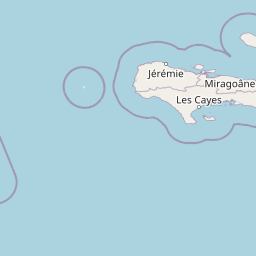
Map view of Massif de la Hotte

Use this park location map to pinpoint Massif de la Hotte in Haiti, understand its exact geographic position, and read its mapped placement within the surrounding landscape more clearly.

Pigeon | © OpenStreetMap contributors
Park atlas

Compare adjacent mountain reserves and regional conservation areas in the Caribbean hotspot

Explore Other Parks Near Massif de la Hotte and Surrounding Protected Landscapes

Browse protected areas near Massif de la Hotte to examine contiguous mountain terrain and regional cloud forest habitats. Extending the geographic review helps map broader biodiversity patterns across the surrounding Tiburon Peninsula.
National parkHaiti
About 1.4 km away#1 closest

Southeast

Pic Macaya National Park: Haiti's Protected Cloud Forest and Mountain Geography

Explore critical endemic species within Haiti's mountainous protected areas.

Pic Macaya National Park stands as a significant natural sanctuary in Haiti, preserving the island's final remnants of virgin cloud forest within the challenging terrain of the Massif de la Hotte. This protected area is defined by its high-altitude volcanic and karstic landscape, including Pic Macaya, the second-highest peak in Haiti. The park is a crucial stronghold for biodiversity, harboring numerous species endemic to Hispaniola, making it an essential site for conservation and a focal point for understanding regional natural landscapes.

Area
80 km²
Established
1984
IUCN
II
Relief
Mountain
National parkSud
About 5.9 km away#2 closest

South

Parc national de Macaya: Mountain Geography and Protected Area Map of Southern Haiti

Cloud forest summits and hydrological landscapes in Sud

This protected area represents one of the most significant biodiversity reserves in the Caribbean. By safeguarding high-elevation cloud forests and steep mountain terrain within the Sud region, the park sustains rare endemic flora and vital watersheds that define the southern Haitian landscape.

Area
20 km²
Established
1983
IUCN
II
A watercolor illustration showing a band of lush green tropical foliage, ferns, and pink flowering plants against a soft, light background.
National parkSud
About 8.2 km away#3 closest

West

Parc national naturel de Grande Colline: Mountain Geography and Protected Area Atlas

A remote, high-altitude primary forest reserve in the Massif de la Hotte

Trace the boundaries of Parc national naturel de Grande Colline, an inaccessible mountain sanctuary characterized by deep ravines, cloud forests, and permanent rivers. As a central biodiversity site within Haiti, the terrain spans five major summits and protects key headwaters for the southern coastline. This atlas entry provides an overview of the park's geographic significance and primary forest habitat.

Area
15.1 km²
Established
2014
IUCN
II
Relief
Mountain
Watercolor painting of a mountainous landscape with green valleys and distant peaks.
National parkHaiti
About 8.5 km away#4 closest

West

Grande Colline National Park: Remote Haitian Mountain Protected Landscape

Unique cloud forest, giant tree ferns, and rugged terrain in Haiti.

Grande Colline National Park safeguards crucial montane cloud forest ecosystems in Haiti's Massif de la Hotte. Characterized by its five named peaks and steep ridges, this protected area preserves a landscape of towering tree ferns and intact hardwood forests above 1,800 meters. Its establishment highlights scientific exploration and the ongoing need for conservation in one of the Caribbean's most biodiverse regions, offering a unique glimpse into isolated montane geography.

Area
15.1 km²
Established
2014
IUCN
II
Relief
Mountain
Natural monumentFinland
About 16 km away#5 closest

Southwest

Grotte Marie-Jeanne Natural Monument: Exploring the Geography of Haiti's Longest Cave System

A complex karst labyrinth of limestone galleries and cultural heritage

Grotte Marie-Jeanne represents a premier karst landscape feature in southern Haiti, offering a deep look into a subterranean network of over 50 distinct chambers. This natural monument reveals a multi-tiered geological structure characterized by diverse speleothems and historical inscriptions. The site serves as a vital anchor for understanding the regional karst topography, combining natural formation processes with long-standing human cultural presence within its limestone walls.

Relief
Upland
Climate
Tropical
Access
Access unknown
Scope
Terrestrial
National parkHaiti
About 24 km away#6 closest

West

Deux Mamelles National Park: Protected Cloud Forest and Mountain Terrain in Haiti

Explore Haiti's critical highland cloud forest ecosystem.

Deux Mamelles National Park is a protected area in Haiti renowned for preserving one of the Caribbean's last remaining cloud forest ecosystems. Located on the Tiburon Peninsula, the park centers around Morne Deux Mamelles, a mountain rising to 1,276 meters. Its rugged, dissected limestone terrain supports primary forest at high elevations, making it a significant biodiversity hotspot and a key site for watershed protection. This park offers a glimpse into the unique natural heritage of Haiti's highlands.

Area
22.65 km²
Established
2015
IUCN
II
Relief
Mountain
National parkSud
About 29 km away#7 closest

West

Grand Bois National Park National Park: Protected Mountain Landscape in Sud, Haiti

Discover Haiti's vital primary rainforest and endemic species refuge.

Grand Bois National Park is a critical conservation area in Haiti's Sud region, established to protect the rare primary rainforest ecosystem found on the isolated Morne Grand Bois peak. This national park safeguards approximately 3.7 square kilometers of mountainous terrain above 900 meters, featuring a unique cloud forest environment. It is a vital refuge for endemic species, including rediscovered amphibians and rare flora, making it a significant site for Caribbean biodiversity and landscape conservation. The park's importance lies in preserving one of Haiti's last intact forest ecosystems.

Area
3.7 km²
Established
2015
IUCN
II
Relief
Mountain
A horizontal watercolor painting depicting a soft-focus, layered view of green rolling hills and distant mountain ranges with hints of pale pink and yellow light.
National parkSud
About 29 km away#8 closest

West

Parc national du Grand Bois: Geographic Profile and Protected Forest Boundaries

High-elevation montane terrain within the Sud department of Haiti

Parc national du Grand Bois protects an ecologically significant remnant of primary tropical and cloud forest on the isolated Morne Grand Bois peak. The park's steep, basin-like geography creates a unique refuge for endemic biodiversity and critical watershed protection in the Sud region, showcasing a distinct topographic boundary that contrasts sharply with the surrounding deforested slopes of the Tiburon Peninsula.

Area
3.702 km²
Established
2015
IUCN
II

Common questions about visiting, size, designation, and location context for Massif de la Hotte

Massif de la Hotte FAQs for park facts, access, geography, and protected area context

Find quick answers about Massif de la Hotte, including protected-area facts, park geography, trail and visitor context, and how the park fits into its surrounding country and regional landscape.
MoriAtlas Explorer

Continue Your Protected Areas Search Across the Global Atlas

Deepen your exploration by continuing the structured search for national parks and protected areas worldwide. Utilize the comprehensive filtering capabilities to compare different conservation landscapes and refine your understanding of global park geography. Discover more about the distribution and characteristics of protected natural areas.

Global natural geography