

Mori Atlas logo
National parkMiddle Button Island National Park

Discover the protected landscape identity and regional context within the Andaman and Nicobar.

Middle Button Island National Park: National Park with Mapped Geographic Boundaries

Middle Button Island National Park stands as a distinct protected area within the Andaman and Nicobar region, offering valuable insights into its mapped geographic boundaries and natural landscape. This national park provides a focused lens for understanding regional conservation patterns and the specific terrain it encompasses. Explore its identity as a significant protected land, contributing to the broader geographic tapestry of the Andaman and Nicobar. Gain a structured understanding of this park's place in the natural world, essential for detailed atlas exploration.

Andaman Islandsisland national parkmoist deciduous forestmarine protected areacoral reefstropical islands

Middle Button Island National Park

National park

Park overview

Structured park overview, official facts, and landscape profile for Middle Button Island National Park

Middle Button Island National Park park facts, protected area profile, and essential visitor context
Review the core facts for Middle Button Island National Park, including designation, size, terrain, visitor scale, habitats, and operating context in one park-focused overview.

About Middle Button Island National Park

Middle Button Island National Park represents one of the more isolated protected areas in India's island territories. The park occupies the entirety of Middle Button Island, a significant landmass in the Andaman archipelago that rises from the eastern Bay of Bengal. The island's interior supports a complex moist deciduous forest ecosystem, while its perimeter features sandy beaches that give way to clear, shallow marine waters. This combination of terrestrial and coastal environments makes the park ecologically diverse despite its relatively compact size. The park's establishment in 1979 reflected growing recognition of the Andaman Islands' unique biodiversity value, and it forms part of a broader marine protection framework that includes adjacent Button Islands. Access requires boat travel from Port Blair, and the park maintains a minimal development footprint with no permanent visitor accommodations, preserving its wilderness character.

Quick facts and research context for Middle Button Island National Park

The park occupies Middle Button Island in the South Andaman administrative district. It was formally established as a national park in 1979 and covers about 64 square kilometers. The island experiences an oceanic climate with temperatures ranging from 20 to 30 degrees Celsius, influenced by the surrounding sea. The wet monsoon season occurs between June and October, while the drier, more comfortable visitor season runs from December through April. The park forms a conservation cluster with North Button and South Button islands, collectively forming the Rani Jhansi Marine National Park.

Park context

Deeper park guide and search-rich context for Middle Button Island National Park

Middle Button Island National Park history, landscape, wildlife, and travel context
Explore Middle Button Island National Park through its history, landscape character, ecosystems, wildlife, conservation priorities, cultural context, and seasonal travel timing in a structured park guide built for atlas discovery and search intent.

Why Middle Button Island National Park stands out

Middle Button Island is best known for its combination of dense moist deciduous forest covering the island's interior and the vibrant marine ecosystems surrounding its coastline. The park protects significant populations of spotted deer and various reptile species including water lizards and monitor lizards. In the surrounding waters, dugongs, dolphins, sea turtles, and numerous coral species create a rich marine environment, with blue whales occasionally reported offshore. The island's relative remoteness and lack of development have helped preserve its natural character.

Middle Button Island National Park history and protected-area timeline

Middle Button Island National Park was created in 1979 as part of India's expanding network of national parks during the latter decades of the twentieth century. The establishment came during a period of increased environmental awareness in India and reflected the government's commitment to protecting the unique ecosystems found in the Andaman and Nicobar Islands. The park was integrated into the Rani Jhansi Marine National Park framework, linking it with North Button Island National Park and South Button Island National Park to form a contiguous protected marine and terrestrial zone off the coast of South Andaman Island. This clustering approach recognized the ecological connections between the islands' land and sea environments.

Middle Button Island National Park landscape and geographic character

Middle Button Island features a terrain characteristic of the Andaman archipelago, with the island's central area rising to create an interior landscape of forested hills and slopes. The vegetation is dominated by moist deciduous forest that covers the island's land surface, creating a dense green canopy across the island's interior. Around the island's perimeter, sandy beaches meet the sea, with clear, shallow waters surrounding the island extending to the reef systems beyond. The island's position in the Bay of Bengal places it within a tropical marine environment characterized by warm waters and seasonal monsoonal influences that shape both the terrestrial and coastal landscapes.

Middle Button Island National Park ecosystems, habitats, and plant life

The island's forest ecosystem supports a diverse array of plant species adapted to the moist tropical conditions. The vegetation includes numerous tree species such as Calophyllum, Canarium, Dipterocarpus, Hopea, and Artocarpus, along with climbing bamboos and rattan palms that create a structurally complex forest. The surrounding marine environment features coral reef systems that support extensive marine biodiversity, thriving in the clear, shallow waters around the island. The combination of forested interior and coral-ringed coast creates a coherent island ecosystem where terrestrial and marine environments are intimately connected.

Middle Button Island National Park wildlife and species highlights

The terrestrial wildlife community includes spotted deer, which represent a significant herbivore population on the island. Reptiles are well represented, with water lizards and monitor lizards commonly observed. The surrounding marine waters host a remarkable diversity of species, including dugongs that graze on seagrass beds, several dolphin species, and sea turtles that use the coastal waters and beaches. The fish community is diverse, and extensive coral reefs provide habitat for numerous reef species. Notable marine mammal sightings include blue whales reported in the waters off the island, representing one of the larger marine species found in the park's jurisdiction.

Middle Button Island National Park conservation status and protection priorities

Middle Button Island National Park contributes to the protection of both the Andaman Islands' terrestrial biodiversity and the marine ecosystems of the eastern Bay of Bengal. The park's inclusion within the broader Rani Jhansi Marine National Park framework creates a unified protection zone that addresses the ecological connections between island forests and surrounding seas. The protected status helps preserve habitat for species including dugongs and sea turtles, which are both listed as threatened. The relatively limited access and minimal development within the park boundaries reduce anthropogenic pressures on the ecosystem, supporting long-term conservation objectives.

Middle Button Island National Park cultural meaning and human context

The Andaman and Nicobar Islands have a complex human history, though Middle Button Island itself does not have documented indigenous settlement of significant scale. The islands' isolation has largely shaped their human history, with the primary historical settlements developing on larger islands. The park's cultural context relates primarily to its position within the broader Andaman archipelago, which has been historically associated with various indigenous peoples and more recently with colonial and post-colonial Indian administration.

Top sights and standout views in Middle Button Island National Park

The park's standout qualities include its remote island setting in the Andaman archipelago, its intact moist deciduous forest, and the rich marine environment that surrounds it. The opportunity to observe dugongs, dolphins, and sea turtles in their natural habitat represents a major draw for visitors. The coral reef systems provide excellent underwater ecosystems, and the island's relative remoteness offers a wilderness experience quite different from more accessible mainland parks. The cluster of protected Button Islands creates a meaningful conservation complex worth exploring.

Best time to visit Middle Button Island National Park

The optimal visiting period runs from December through April, when the northeast monsoon brings drier conditions and more comfortable temperatures. During this season, visitors can expect clearer skies and calmer seas, making boat access more reliable and underwater visibility better for marine observation. The southwest monsoon season from June through October brings heavy rainfall and rougher sea conditions, which significantly limit access and reduce the appeal of visiting. The temperature remains warm throughout the year, typically between 20 and 30 degrees Celsius, with the coolest months generally offering the most pleasant conditions for outdoor exploration.
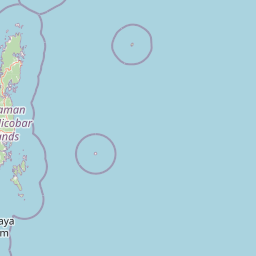
Park location guide

Geography guide, regional context, and park location map for Middle Button Island National Park

Middle Button Island National Park park geography, regions, and map view in India
Understand where Middle Button Island National Park sits in India through a broader geographic reading of the surrounding landscape, nearby location context, and its mapped position within the national park landscape.

How Middle Button Island National Park fits into India

India is a South Asian country bordered by the Indian Ocean, Arabian Sea, and Bay of Bengal. It shares land borders with Pakistan, China, Nepal, Bhutan, Bangladesh, and Myanmar. The country has a population of over 1.4 billion people and operates as a federal parliamentary republic with its capital in New Delhi.

Wider geography shaping Middle Button Island National Park in India

India occupies the Indian subcontinent in South Asia, bordered by the Arabian Sea to the southwest, the Bay of Bengal to the southeast, and the Indian Ocean to the south. It shares land borders with Pakistan to the west, China, Nepal, and Bhutan to the north, and Bangladesh and Myanmar to the east. The territory also includes the Andaman and Nicobar Islands in the Indian Ocean.

Map view of Middle Button Island National Park

Use this park location map to pinpoint Middle Button Island National Park in India, understand its exact geographic position, and read its mapped placement within the surrounding landscape more clearly.

Pigeon | © OpenStreetMap contributors

Location context for Middle Button Island National Park

Andaman and Nicobar
Park atlas

Explore Adjacent Protected Areas and Marine Reserves in the Bay of Bengal, Expanding Your Atlas of Island Conservation

Discover Other National Parks Near Middle Button Island and Its Andaman Archipelago Marine Protected Area
Continue your exploration from Middle Button Island National Park by browsing other protected areas and marine reserves throughout the Andaman and Nicobar archipelago. This curated view offers valuable geographic context and enables deeper atlas discovery of interconnected island ecosystems within the broader Bay of Bengal region.
National parkAndaman and Nicobar Islands

Mount Harriet National Park: National Park Mapping and Protected Landscape Identity

Explore its endemic biodiversity and mountain forest terrain.

Mount Harriet National Park provides a deep dive into a unique protected landscape, offering detailed insights into its geography, terrain, and ecological significance within the Andaman and Nicobar Islands. As a national park, it showcases a remarkable combination of mountainous forest ecosystems and coastal environments, serving as a vital habitat for numerous endemic species. Understanding its mapped boundaries and regional geographic context reveals why this protected area is a key point of interest for atlas-based natural landscape exploration.

Area
46.62 km²
Established
1979
IUCN
II
Relief
Mountain
National parkIndia

Mahatma Gandhi Marine National Park: India National Park Protected Landscape and Geography

Explore mapped boundaries and regional geographic context.

Gain a detailed understanding of Mahatma Gandhi Marine National Park, a designated national park in India. This entry focuses on its protected area status, the mapped extent of its natural landscape, and its significance within India's diverse geography. Discover the park's spatial context and contribution to the nation's protected lands through an atlas-focused lens, providing essential geographic details for informed exploration.

Area
281.5 km²
Established
1983
IUCN
II
Relief
Lowland
National parkTanintharyi Region

Lampi Island Marine National Park National Park: Geographic Atlas and Protected Landscape Overview

Discover mapped boundaries and regional park geography.

Lampi Island Marine National Park is a designated national park offering a focused lens on protected landscapes and regional geography. Explore its precise mapped boundaries and understand its place within the Tanintharyi Region's natural terrain. This profile is designed for atlas-based discovery, providing essential geographic context for the park and its role as a conservation area.

Area
204.8 km²
Established
1996
IUCN
II
Relief
Mixed relief
National parkAndaman and Nicobar Islands

Galathea National Park: National Park Protected Landscape and Geography

Explore mapped boundaries within the Andaman and Nicobar Islands.

Galathea National Park serves as a vital protected landscape, contributing to the rich geographic tapestry of the Andaman and Nicobar Islands. This canonical MoriAtlas entry provides essential atlas-driven details about the park's identity as a national park. Focus is placed on its mapped presence and regional geographic context, allowing for structured exploration of its protected status and landscape features for users interested in detailed geographic and conservation mapping.

Area
110 km²
Established
1992
IUCN
II
Relief
Lowland
National parkKanchanaburi Province

Thong Pha Phum National Park: A Protected Landscape in Kanchanaburi Province, Thailand

National park mapped geography and regional context.

Thong Pha Phum National Park is a significant national park in Thailand, situated within Kanchanaburi Province. This page details its protected area status and provides essential geographic context, enabling users to explore its mapped boundaries and understand its role within the regional landscape. Focus on discovery of its natural terrain and atlas-relevant characteristics.

Area
1,236 km²
Established
2009
IUCN
II
Visitors
123.3K annual
Watercolor illustration of a serene landscape featuring a body of water, distant hills, and green vegetation
National parkKanchanaburi Province

Sai Yok National Park: Protected Landscape Boundaries and Regional Geographic Context

Explore the mapped terrain and park geography within Kanchanaburi.

Sai Yok National Park serves as a vital protected area within Kanchanaburi Province, offering a clear focus for geographic exploration and atlas-based understanding. This entry details the park's specific mapped boundaries and its role within the broader regional landscape context, providing essential data for comprehending its natural geography and conservation significance.

Area
500 km²
Established
1980
IUCN
II
Visitors
67.7K annual
National parkRanong

Laem Son National Park: A Protected National Park in Ranong's Geographic Landscape

Explore the mapped natural terrain and protected area boundaries.

Laem Son National Park is a key protected area within Thailand's Ranong province, offering valuable insights into regional geography and landscape preservation. This entry focuses on its status as a national park, providing a structured view of its protected boundaries and environmental context. Understand its unique position within the mapped geography, vital for any comprehensive atlas exploration of protected lands in the region.

Area
315 km²
Established
1983
IUCN
II
Visitors
21.9K annual
National parkKanchanaburi Province

Khao Laem National Park: Kanchanaburi Province Protected Landscape Atlas

Discover mapped terrain and regional geographic context.

Investigate Khao Laem National Park as a distinct protected landscape situated in Thailand's Kanchanaburi Province. This entry provides detailed geographic insights, focusing on mapped boundaries and the park's position within the region's natural atlas. It's designed for users seeking specific protected-area data and landscape context rather than general visitor information.

Area
1,497 km²
Established
1991
IUCN
II
Visitors
48.6K annual

Common questions about visiting, size, designation, and location context for Middle Button Island National Park

Middle Button Island National Park FAQs for park facts, access, geography, and protected area context
Find quick answers about Middle Button Island National Park, including protected-area facts, park geography, trail and visitor context, and how the park fits into its surrounding country and regional landscape.
MoriAtlas Explorer

Continue Your Protected Areas Search Across the Global Atlas

Deepen your exploration by continuing the structured search for national parks and protected areas worldwide. Utilize the comprehensive filtering capabilities to compare different conservation landscapes and refine your understanding of global park geography. Discover more about the distribution and characteristics of protected natural areas.

Global natural geography