

Mori Atlas logo
National parkGalathea National Park

Trace the mapped boundaries and geographic context of this national park.

Galathea National Park: A Protected Landscape in the Andaman and Nicobar Islands

Galathea National Park represents a significant protected natural area within the archipelago of the Andaman and Nicobar Islands. As a national park, its designation highlights its importance for conservation and geographic study. This entry offers an atlas-focused perspective, detailing the park's mapped boundaries and its role within the regional geography, providing a factual foundation for understanding its landscape identity for dedicated exploration.

Tropical RainforestEndemic SpeciesSea Turtle NestingUNESCO Biosphere ReserveIsland ConservationLeatherback Turtle

Galathea National Park

National park

Park overview

Structured park overview, official facts, and landscape profile for Galathea National Park

Galathea National Park park facts, protected area profile, and essential visitor context
Review the core facts for Galathea National Park, including designation, size, terrain, visitor scale, habitats, and operating context in one park-focused overview.

About Galathea National Park

Galathea National Park represents one of India's most ecologically significant protected areas, situated on the remote and relatively undeveloped Great Nicobar Island at the southern end of the Andaman and Nicobar archipelago. The park's establishment in 1992 reflected growing recognition of the island's extraordinary biological wealth and the need to protect its tropical rainforest ecosystems from development pressures. The park forms part of the Great Nicobar Biosphere Reserve, a comprehensive conservation framework that also includes Campbell Bay National Park, with the two protected areas separated by a 12-kilometre forest buffer zone that maintains ecological connectivity across the island's interior. The park's location in the eastern Indian Ocean places it at the crossroads of several biogeographic regions, contributing to its exceptional species diversity and high levels of endemism. The indigenous Great Nicobarese people have historically inhabited the island, though their presence within the park boundaries is limited, allowing the forest ecosystems to remain in a relatively natural state. The park's isolation has been both a blessing and a challenge, as it has preserved ecological integrity while also making scientific study and conservation management more difficult to conduct.

Quick facts and research context for Galathea National Park

Galathea National Park occupies 110 square kilometres on Great Nicobar Island in the Nicobar Islands chain, situated in the Bay of Bengal. The park was formally established as a national park in 1992 and operates under IUCN Category II protection. It forms part of the larger Great Nicobar Biosphere Reserve, which also encompasses Campbell Bay National Park separated by a 12-kilometre forest buffer zone. The region experiences an acute tropical climate with only summer and monsoon seasons, recording between 3000 and 3800 millimetres of rainfall annually during the wet season. The park takes its name from the Danish colonial vessel Galathea, which conducted mineral surveys on Great Nicobar between 1845 and 1847.

Park context

Deeper park guide and search-rich context for Galathea National Park

Galathea National Park history, landscape, wildlife, and travel context
Explore Galathea National Park through its history, landscape character, ecosystems, wildlife, conservation priorities, cultural context, and seasonal travel timing in a structured park guide built for atlas discovery and search intent.

Why Galathea National Park stands out

Galathea National Park is renowned for its exceptionally preserved tropical rainforest ecosystems and remarkable endemic biodiversity. The park protects critical habitat for several notable species including the giant robber crab, one of the world's largest terrestrial arthropods; the megapode, a ground-nesting bird; and the Nicobar pigeon, a colourful endemic bird species. The park also serves as a significant nesting site for leatherback sea turtles, the largest turtles in the world, which nest along its shores from February through December. The isolation of Great Nicobar Island has allowed unique species to evolve and persist, making the park a living laboratory for understanding island biogeography and tropical rainforest ecology.

Galathea National Park history and protected-area timeline

The formal protection of Galathea National Park began with its establishment in 1992, when the Indian government designated the area as a national park under the Wildlife Protection Act. However, the conservation context for Great Nicobar Island had been developing earlier, with the broader Great Nicobar Biosphere Reserve being declared by the government in 1989. This biosphere reserve designation reflected recognition that the island's ecosystems required coordinated protection across multiple use zones rather than isolated protected areas alone. The significance of this conservation framework was further acknowledged when the Great Nicobar Biosphere Reserve was recognised as a UNESCO Biosphere Reserve in 2013 under the Man and the Biosphere Programme, joining an international network of sites designated for their ecological significance and sustainable development frameworks. The park's name honours the Danish colonial vessel Galathea, which conducted comprehensive mineral surveys on Great Nicobar between 1845 and 1847 during Denmark's colonial presence in the region, linking the park's identity to the historical maritime exploration of these remote islands.

Galathea National Park landscape and geographic character

The terrain of Galathea National Park is characterised by the dense, humid tropical rainforest that covers Great Nicobar Island's interior. The island rises from the sea with a landscape of rolling hills and valleys carved by numerous small streams that flow toward the coastline. The park encompasses coastal areas as well as inland forest, providing protection to both the shoreline ecosystems and the island's interior rainforest. The forest composition features tropical and subtropical moist broadleaf trees forming a multi-layered canopy that creates the dark, humid understorey typical of mature rainforest. The surrounding waters of the Bay of Bengal and Indian Ocean add marine and coastal elements to the park's landscape diversity, with beaches and rocky shores serving as important turtle nesting areas. The overall impression is one of lush, unbroken tropical vegetation meeting the sea, representing a relatively unmodified landscape compared to many other coastal areas in the region.

Galathea National Park ecosystems, habitats, and plant life

Galathea National Park protects what are considered among the world's best-preserved tropical rainforests, characterised by exceptional biological richness and high levels of endemism. The vegetation consists predominantly of tropical and subtropical moist broadleaf forests that have developed in the island's hot, humid climate with heavy monsoon rainfall. These forests support complex ecological communities with multiple layers of vegetation from the forest floor through the emergent trees. The park's position in the eastern Indian Ocean and its relative geographic isolation have allowed distinctive species to evolve independently, creating a unique biological profile that differs substantially from both the mainland and other islands in the region. The Great Nicobar Biosphere Reserve framework recognises these values and provides the broader conservation context within which Galathea National Park operates, connecting this protected area to the wider landscape of the island.

Galathea National Park wildlife and species highlights

The wildlife of Galathea National Park features several species of outstanding conservation interest that exemplify the park's ecological significance. The giant robber crab, also known as the coconut crab, represents one of the largest terrestrial invertebrates in the world and is found within the park's forest habitats. The megapode, a distinctive ground-nesting bird, inhabits the island's forests and is known for its unique breeding behaviour using geothermal heat to incubate eggs. The Nicobar pigeon, a striking bird endemic to the Nicobar Islands, is a prominent resident species with its colourful plumage providing visual evidence of the island's distinctive evolutionary heritage. Perhaps most significantly, the park serves as a critical nesting site for leatherback sea turtles, the largest of all turtle species, which come ashore from February through December to lay their eggs on the beach. The presence of these diverse and notable species reflects the ecological integrity of the park's habitats and the importance of protecting these species from various threats.

Galathea National Park conservation status and protection priorities

Galathea National Park holds significant conservation value as a protected area preserving some of India's last remaining tracts of pristine tropical rainforest and the endemic species they support. The park's inclusion within the Great Nicobar Biosphere Reserve provides a framework for integrated conservation that recognises the connections between the park's interior forests and the broader island landscape. The UNESCO Biosphere Reserve designation in 2013 acknowledged both the ecological significance and the need for sustainable management approaches. However, the park faces considerable conservation challenges from proposed development activities. The Indian government's Great Nicobar Development Plan proposes substantial infrastructure including an international container transshipment port, airport upgrades, power generation facilities, and a new township that could fundamentally alter the island's character and put pressure on the park's ecosystems. These development proposals represent the most significant current threat to the conservation values that Galathea National Park was established to protect.

Galathea National Park cultural meaning and human context

Great Nicobar Island has been home to the indigenous Great Nicobarese people for generations, though the park's interior areas remain largely uninhabited. The name Galathea National Park itself reflects the island's colonial history, being derived from the Danish vessel that surveyed the island in the mid-19th century during Denmark's colonial presence in the region. This historical connection to Danish India provides cultural context for understanding the island's place in regional history. The park's relatively recent establishment in 1992 reflects the modern conservation movement's recognition of the island's global significance, building upon the earlier biosphere reserve designation that acknowledged the need to balance ecological protection with sustainable development considerations for local communities.

Top sights and standout views in Galathea National Park

Galathea National Park protects exceptional tropical rainforest ecosystems on one of India's most remote islands, harbouring species found nowhere else on Earth. The park's critical importance for leatherback sea turtle nesting, with turtles visiting from February to December, represents a globally significant reproductive habitat for the world's largest turtle species. The presence of giant robber crabs, megapodes, and Nicobar pigeons provides visible evidence of the island's distinctive endemic wildlife. The park forms the core of the Great Nicobar Biosphere Reserve, which gained UNESCO recognition in 2013, confirming its international conservation significance. These values exist against the backdrop of proposed development pressures that could transform the island's future.

Best time to visit Galathea National Park

The climate of Great Nicobar Island features only two seasons, summer and monsoon, with no winter conditions experienced on the island. The monsoon season brings extremely heavy rainfall, with annual precipitation ranging from 3000 to 3800 millimetres. For those planning to visit Galathea National Park, the dry summer months generally offer more comfortable conditions for exploration, though the remote location and limited infrastructure make independent visits challenging. The leatherback turtle nesting season from February through December provides the most compelling wildlife viewing opportunity, with nesting activity occurring over an extended period. However, visitors should note that the park's extreme isolation and limited tourism infrastructure mean that access is not straightforward and requires careful advance planning.
Park location guide

Geography guide, regional context, and park location map for Galathea National Park

Galathea National Park park geography, regions, and map view in India
Understand where Galathea National Park sits in India through a broader geographic reading of the surrounding landscape, nearby location context, and its mapped position within the national park landscape.

How Galathea National Park fits into India

India is a South Asian country bordered by the Indian Ocean, Arabian Sea, and Bay of Bengal. It shares land borders with Pakistan, China, Nepal, Bhutan, Bangladesh, and Myanmar. The country has a population of over 1.4 billion people and operates as a federal parliamentary republic with its capital in New Delhi.

Wider geography shaping Galathea National Park in India

India occupies the Indian subcontinent in South Asia, bordered by the Arabian Sea to the southwest, the Bay of Bengal to the southeast, and the Indian Ocean to the south. It shares land borders with Pakistan to the west, China, Nepal, and Bhutan to the north, and Bangladesh and Myanmar to the east. The territory also includes the Andaman and Nicobar Islands in the Indian Ocean.

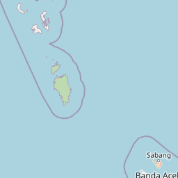
Map view of Galathea National Park

Use this park location map to pinpoint Galathea National Park in India, understand its exact geographic position, and read its mapped placement within the surrounding landscape more clearly.

Pigeon | © OpenStreetMap contributors

Location context for Galathea National Park

Andaman and Nicobar Islands
Park atlas

Trace conserved landscapes, compare adjacent wilderness areas, and map island ecosystems across the region.

Explore National Parks and Protected Areas Near Galathea National Park on Great Nicobar
Continue your exploration from Galathea National Park to discover other significant protected areas and national parks across the Nicobar Islands and surrounding geographic regions. Browse detailed park profiles, compare their unique tropical ecosystems, and map their placement within broader conservation landscapes for a richer atlas understanding.
National parkPhuket Province

Sirinat National Park: Phuket Province Protected Coastal Landscape and Marine Atlas

Mapped boundaries, beach forests, and sea turtle nesting sites.

Sirinat National Park offers a unique opportunity to explore a protected coastal geography on Phuket Island. This national park preserves critical beach forest ecosystems, extensive shorelines like Hat Mai Khao, vital sea turtle nesting grounds, and surrounding marine environments including coral reefs and mangrove habitats. Its designation as a protected area provides essential context for understanding the natural landscape and its ecological significance within Thailand's regional geography.

Area
90 km²
Established
1981
IUCN
II
Visitors
51.2K annual
National parkPhang Nga Province

Khao Lampi, Hat Thai Mueang National Park: Mountain Rainforest and Andaman Coast Atlas

Explore the mapped geography and protected boundaries.

Delve into Khao Lampi, Hat Thai Mueang National Park, a key protected area within Phang Nga Province, Thailand. This unique national park showcases a striking dichotomy: the lush, waterfall-adorned slopes of the Khao Lampi mountains contrast with the pristine Andaman Sea coastline of Hat Thai Mueang beach, a critical site for sea turtle nesting. The park's mapped landscape encompasses dense tropical rainforest, significant mangrove ecosystems, and important natural terrain, offering a comprehensive view of diverse protected environments for atlas exploration.

Area
72 km²
Established
1986
IUCN
II
Visitors
50.5K annual
National parkPhang Nga Province

Khao Lak, Lam Ru National Park: Protected National Park Landscape and Geography

Explore its mapped boundaries and regional context in Phang Nga Province.

This entry focuses on Khao Lak, Lam Ru National Park, a designated national park offering a distinct protected landscape within Phang Nga Province, Thailand. It provides structured data and map context crucial for understanding its geographic scope and regional significance. Explore the park's mapped boundaries, its role as a protected area, and its contribution to the broader landscape of southern Thailand, fostering a deeper appreciation for its natural geography and atlas-derived insights.

Area
125 km²
Established
1991
IUCN
II
Visitors
72.2K annual
National parkIndia

Mahatma Gandhi Marine National Park: India National Park Protected Landscape and Geography

Explore mapped boundaries and regional geographic context.

Gain a detailed understanding of Mahatma Gandhi Marine National Park, a designated national park in India. This entry focuses on its protected area status, the mapped extent of its natural landscape, and its significance within India's diverse geography. Discover the park's spatial context and contribution to the nation's protected lands through an atlas-focused lens, providing essential geographic details for informed exploration.

Area
281.5 km²
Established
1983
IUCN
II
Relief
Lowland
National parkThailand

Ao Phang Nga National Park: A Protected National Park in Thailand's Geographic Atlas

Explore the mapped landscape and protected area identity.

Ao Phang Nga National Park offers a distinct protected landscape within Thailand, serving as a key entry in the national park atlas. This page focuses on delineating its geographic boundaries and understanding its specific characteristics as a national park. Users can discover the mapped context and regional setting, providing valuable insights into Thailand's protected natural areas and their conservation significance.

Area
400 km²
Established
1981
IUCN
II
Visitors
999K annual
National parkAndaman and Nicobar Islands

Mount Harriet National Park: National Park Mapping and Protected Landscape Identity

Explore its endemic biodiversity and mountain forest terrain.

Mount Harriet National Park provides a deep dive into a unique protected landscape, offering detailed insights into its geography, terrain, and ecological significance within the Andaman and Nicobar Islands. As a national park, it showcases a remarkable combination of mountainous forest ecosystems and coastal environments, serving as a vital habitat for numerous endemic species. Understanding its mapped boundaries and regional geographic context reveals why this protected area is a key point of interest for atlas-based natural landscape exploration.

Area
46.62 km²
Established
1979
IUCN
II
Relief
Mountain
National parkKrabi Province

Hat Noppharat Thara, Mu Ko Phi Phi National Park: Protected Landscape and Geographic Identity

Explore mapped terrain and protected natural areas in Krabi Province.

Hat Noppharat Thara, Mu Ko Phi Phi National Park stands as a distinct protected natural landscape, offering a unique geographic perspective within Krabi Province. This page delves into its role as a national park, highlighting its mapped boundaries and contribution to the regional atlas. Users can explore the park's specific natural terrain and understand its significance as a conservation area, providing a foundation for broader geographic discovery.

Area
388 km²
Established
1983
IUCN
II
Visitors
1.1M annual
National parkIndonesia

Gunung Leuser National Park: A Critical Protected Landscape in Indonesia's Barisan Mountains

Discover its mountainous terrain and primate conservation significance.

Gunung Leuser National Park is a significant protected area in Indonesia, encompassing 3,208 square kilometers of diverse tropical rainforest and rugged mountainous terrain within the Barisan mountain range. Its designation as a national park highlights its role in preserving critical ecosystems, including one of the last remaining habitats for the Sumatran orangutan. This atlas entry provides a geographic overview of the park's landscape, focusing on its protected boundaries and ecological importance within the region.

Area
3,208 km²
Established
1980
IUCN
II
Relief
Mountain

Common questions about visiting, size, designation, and location context for Galathea National Park

Galathea National Park FAQs for park facts, access, geography, and protected area context
Find quick answers about Galathea National Park, including protected-area facts, park geography, trail and visitor context, and how the park fits into its surrounding country and regional landscape.
MoriAtlas Explorer

Continue Your Protected Areas Search Across the Global Atlas

Deepen your exploration by continuing the structured search for national parks and protected areas worldwide. Utilize the comprehensive filtering capabilities to compare different conservation landscapes and refine your understanding of global park geography. Discover more about the distribution and characteristics of protected natural areas.

Global natural geography

