Mori Atlas logo
National parkMkomazi National Park

Explore the mapped boundaries and semi-arid savanna ecosystem of this vital East African protected area.

Mkomazi National Park: Tanzania National Park Atlas & Protected Landscape Geography

Mkomazi National Park represents a significant protected landscape in northern Tanzania, characterized by vast Acacia-Commiphora savanna woodland across over 3,200 square kilometers. As a national park, its identity is deeply rooted in its expansive mapped boundaries and critical role within the East African atlas, particularly for its successful black rhinoceros and African wild dog conservation programs. This page offers an entry point to understanding the park's unique semi-arid terrain, its ecological importance as a transboundary conservation link with Kenya, and the broader regional geography it inhabits.

Savanna EcosystemsTransboundary ConservationBlack RhinocerosAfrican Wild DogEast AfricaSemi-Arid Landscape

Mkomazi National Park

National park

Park overview

Structured park overview, official facts, and landscape profile for Mkomazi National Park

Mkomazi National Park park facts, protected area profile, and essential visitor context

Review the core facts for Mkomazi National Park, including designation, size, terrain, visitor scale, habitats, and operating context in one park-focused overview.

About Mkomazi National Park

Mkomazi National Park represents one of Tanzania's most significant conservation landscapes, encompassing a vast expanse of semi-arid savanna in the country's northern highlands. The park's territory actually comprises two former game reserves: the Umba Game Reserve in the eastern portion within Tanga Region and the Mkomazi Game Reserve in the western portion within Kilimanjaro Region. Together these form a contiguous protected area that serves as a critical ecological corridor connecting Tanzanian and Kenyan conservation lands. The park's Acacia-Commiphora vegetation dominates the terrain, creating the characteristic park-like savanna scenery that defines much of eastern Africa's protected landscapes. This vegetation community supports a diverse array of wildlife species adapted to semi-arid conditions. The park's location in the rain shadow of the Usambara Mountains creates a unique ecological setting that differs from the wetter highland forests found nearby, supporting drought-adapted species and creating important habitat for species that thrive in drier conditions.

Quick facts and research context for Mkomazi National Park

Mkomazi National Park covers approximately 3,234 square kilometers in northern Tanzania, making it one of the larger protected areas in the country. The park straddles Same District in Kilimanjaro Region and Lushoto District in Tanga Region, with a small portion extending into Mkinga District. It was designated as a game reserve in 1951 and achieved full national park status in 2006. The park is managed by the Tanzania National Parks Authority and shares an unfenced border with Tsavo West National Park in Kenya, facilitating wildlife movement across the transboundary landscape.

Protection and recognition

Verifying the 2006 terrestrial designation and transboundary conservation alignment

Documented Protection Status and Transboundary Geography of Mkomazi National Park

Researchers can examine the terrestrial conservation boundary established in 2006 and the transboundary geography of Mkomazi National Park. Documented protection records outline the historical designation and international context necessary for systematic landscape analysis and comparative regional studies.

Protection details

Protection scope
Terrestrial
Designated year
2006
Transboundary protection
Yes
Park context

Deeper park guide and search-rich context for Mkomazi National Park

Mkomazi National Park history, landscape, wildlife, and travel context

Explore Mkomazi National Park through its history, landscape character, ecosystems, wildlife, conservation priorities, cultural context, and seasonal travel timing in a structured park guide built for atlas discovery and search intent.

Why Mkomazi National Park stands out

Mkomazi is particularly renowned for its black rhinoceros sanctuary, which has become a successful breeding population for this critically endangered species. The park is also a stronghold for African wild dog populations, with dedicated conservation facilities supporting their protection and breeding. The park's transboundary connection with Tsavo West National Park creates one of the largest unfenced conservation areas in East Africa, supporting natural wildlife migration patterns. The restoration of the reserve from a heavily grazed landscape to a thriving protected area represents a significant conservation achievement, though one that came with substantial social costs.

Mkomazi National Park history and protected-area timeline

The history of Mkomazi reflects the complex intersection of colonial conservation policy, post-independence development, and modern wildlife protection priorities. When first established as a game reserve in 1951, the colonial government permitted a limited number of pastoral families from the Parakuyo ethnic group to remain within the reserve with their livestock, recognizing their long-standing presence in the area. This unique arrangement allowed traditional pastoral use in the eastern half of the reserve while establishing conservation boundaries. However, the subsequent decades saw significant immigration by Maasai and other ethnic group pastoralists, leading to dramatic increases in livestock populations that raised serious environmental concerns. By the mid-1980s, an estimated 80,000 cattle grazed within the reserve, prompting government action. In the late 1980s, the Tanzanian government resolved to end all grazing permissions, completing the eviction of all pastoralists by July 1988. Following the evictions, international conservation organizations, particularly the George Adamson Wildlife Preservation Trust and its American partner the Tony Fitzjohn George Adamson African Wildlife Preservation Trust, became instrumental in restoring the reserve. These organizations established fenced sanctuaries for African wild dog and black rhinoceros, rebuilt infrastructure, and developed community outreach programs. The reserve was upgraded to full national park status in 2006, permanently ending any legal possibility of local resource use within the park.

Mkomazi National Park landscape and geographic character

Mkomazi's landscape is defined by rolling semi-arid terrain covered in Acacia-Commiphora woodland, creating the classic East African savanna visual that characterizes much of the region's protected areas. The terrain varies in elevation and relief, with the western portion associated with Mkomazi proper offering greater topographic diversity than the eastern Umba section. The landscape supports scattered rocky outcrops and seasonal watercourses that provide critical water sources for wildlife during dry periods. The park sits in a rain shadow zone, receiving lower rainfall than surrounding highland areas, which shapes the distinctive semi-arid character of the vegetation. An important hydrological feature includes dams and water points that have been developed to support wildlife populations. The park's flat to gently rolling terrain facilitates wildlife viewing and creates vast open spaces that convey the sense of wild, remote landscape that distinguishes Mkomazi from more mountainous Tanzanian parks.

Mkomazi National Park ecosystems, habitats, and plant life

The ecological character of Mkomazi is defined by its extensive Acacia-Commiphora savanna woodland, a vegetation type that dominates large areas of eastern Africa and supports specialized wildlife communities adapted to semi-arid conditions. This woodland ecosystem creates heterogeneous habitat structure with varying densities of woody vegetation and open grassland patches that support different species assemblages. The park's position near the Usambara Mountains influences its ecological character, while the transboundary connection with Tsavo West National Park maintains ecological connectivity essential for large mammal movements. The fenced sanctuaries within the park represent intensive conservation enclaves that provide protected breeding habitat for endangered species, while the broader savanna landscape supports more widespread wildlife populations. The restoration of the reserve following the removal of livestock pressure has allowed native vegetation communities to recover, demonstrating the ecological resilience of East African savanna systems when given protection.

Mkomazi National Park wildlife and species highlights

Mkomazi supports a diverse mammalian fauna typical of East African savanna ecosystems, with several species of particular conservation significance. The black rhinoceros population represents a critical conservation success, with the sanctuary within the park supporting a breeding population of this heavily poached species. African wild dog packs thrive in the park, benefiting from dedicated conservation enclosures and protection from the broader landscape. Large mammals commonly encountered include African elephant, lion, common eland, hartebeest, and Grant's zebra, while spotted hyena represents a common predator species. The park's location near the Usambara Mountains and its varied habitat structure support species diversity beyond what might occur in more uniform landscapes. Wildlife surveys have documented extensive species interactions, reflecting the functional ecological relationships that characterize healthy savanna ecosystems.

Mkomazi National Park conservation status and protection priorities

Mkomazi represents a significant conservation case study in East Africa, demonstrating both the potential for ecosystem restoration and the complex social dimensions of protected area establishment. The successful establishment of black rhinoceros and African wild dog populations represents a tangible conservation achievement that has brought international recognition to the park. The George Adamson Wildlife Preservation Trust and its partners have invested substantially in infrastructure, anti-poaching patrols, and community outreach programs that strengthen park protection and build local support. The transboundary connection with Tsavo West National Park creates one of the largest contiguous protected areas in East Africa, maintaining ecological processes that require large spatial scales. However, the conservation model employed at Mkomazi remains contested, with critics arguing that the eviction of pastoral communities occurred without adequate compensation and that the ecological justification for removing all human presence was not supported by sufficient data. The park continues to face challenges from illegal grazing incursions, particularly during wet seasons, highlighting the ongoing tension between conservation boundaries and traditional land use patterns.

Mkomazi National Park cultural meaning and human context

The cultural history of Mkomazi is deeply intertwined with the pastoral traditions of the Parakuyo and Maasai ethnic communities who historically used the area for livestock grazing. When the reserve was established in 1951, the colonial government permitted Parakuyo pastoralist families to remain in the eastern half of the reserve, recognizing their long-standing relationship with the land. This unique arrangement reflected the complex history of human-wildlife coexistence in East African savanna landscapes. The subsequent eviction of all pastoralists in 1988, including both Maasai and Parakuyo communities, transformed the park from a multi-use landscape to a strictly protected conservation area. The affected communities contested the evictions through Tanzanian courts, claiming customary rights to the land, but lost their case. Contemporary community outreach programs represent attempts to provide benefits to communities surrounding the park, though critics argue these benefits inadequately address the losses experienced by evicted populations. The park thus embodies broader debates about conservation models that separate people from protected landscapes versus approaches that incorporate traditional land use.

Top sights and standout views in Mkomazi National Park

Mkomazi's standout features include its successful black rhinoceros breeding sanctuary, which has become a model for endangered large mammal conservation in East Africa. The African wild dog protection program represents another significant achievement, with dedicated facilities supporting packs of this endangered canid. The park's transboundary connection with Tsavo West National Park creates an extensive unfenced conservation landscape that supports natural wildlife movements across international borders. The vast savanna scenery, characterized by Acacia-Commiphora woodland and open grasslands, offers a classic East African wilderness experience distinct from higher-elevation Tanzanian parks. The park's restoration from a heavily grazed landscape demonstrates the ecological resilience of savanna ecosystems when given protection, with vegetation recovery evident across large areas.

Best time to visit Mkomazi National Park

Mkomazi can be visited throughout the year, though the dry season from June to October typically offers the most reliable wildlife viewing as animals concentrate around remaining water sources. The short rains from November to December and long rains from March to May transform the landscape with fresh vegetation but can make some roads difficult to navigate. The wet seasons also bring greener scenery and excellent birdwatching opportunities, though wildlife becomes more dispersed across the expanded landscape. The park's remote location means fewer visitors than more established Tanzanian destinations, offering a more exclusive safari experience for those willing to venture to this northern boundary region.

Monthly climate preview

Comparing historical temperature ranges and precipitation trends across the Tanzanian savanna landscape

Long-Term Climate Normals and Monthly Weather Patterns in Mkomazi National Park

Long-term records at Mkomazi National Park show mean temperatures from nineteen to twenty-five degrees Celsius alongside shifting precipitation patterns. Exploring the complete twelve-month profile reveals historical temperature ranges and daily precipitation averages to assist with regional geographic comparison.
Annual mean22 °C
19 °C25 °C
Jan24°
Feb25°
Mar24°
Apr23°
May21°
Jun20°
Jul19°
Aug20°
Sep22°
Oct23°
Nov23°
Dec24°
Warmest month
February

25 °C

Coolest month
July

19.4 °C

Wettest month
April

4.7 mm/day

Driest month
July

1 mm/day

Park location guide

Geography guide, regional context, and park location map for Mkomazi National Park

Mkomazi National Park park geography, regions, and map view in Tanzania

Understand where Mkomazi National Park sits in Tanzania through a broader geographic reading of the surrounding landscape, nearby location context, and its mapped position within the national park landscape.

How Mkomazi National Park fits into Tanzania

Tanzania, officially the United Republic of Tanzania, is a presidential republic in East Africa within the African Great Lakes region. It was formed in 1964 through the unification of Tanganyika and Zanzibar. The country is known for its diverse wildlife, national parks including Serengeti and Ngorongoro, and significant archaeological sites with important hominid fossils.

Wider geography shaping Mkomazi National Park in Tanzania

Tanzania is located in East Africa within the African Great Lakes region. It is bordered by Uganda to the northwest, Kenya to the northeast, the Indian Ocean to the east, Mozambique and Malawi to the south, Zambia to the southwest, and Rwanda, Burundi, and the Democratic Republic of the Congo to the west. The country includes the mainland and the Zanzibar Archipelago.

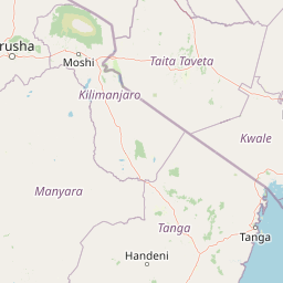
Map view of Mkomazi National Park

Use this park location map to pinpoint Mkomazi National Park in Tanzania, understand its exact geographic position, and read its mapped placement within the surrounding landscape more clearly.

Pigeon | © OpenStreetMap contributors

Location context for Mkomazi National Park

Kilimanjaro RegionTanga Region
Recorded earthquake history

Explore Historical Earthquake Records Associated with Mkomazi National Park

Access a detailed catalogue of recorded seismic events that have occurred in the vicinity of Mkomazi National Park. MoriAtlas provides these historical data points to help users understand the recorded seismic context of the region through verifiable event parameters.

Mkomazi National Park Earthquake History

Catalogued events

7 events

Strongest magnitude

Magnitude 5.3

Most recent event

Feb 25, 2026

This history includes earthquakes recorded inside the park or within 50 km of its borders

Park atlas

Trace the Savanna Ecosystems and Connected Conservation Landscapes Near Mkomazi National Park

Discover Nearby National Parks and Protected Areas, Expanding Your Mkomazi National Park Exploration

Browse a curated list of national parks and protected areas located in the broader East African region, offering geographic context and ecological comparisons to Mkomazi National Park. Continue your protected-area discovery by mapping their regional spread, comparing diverse savanna ecosystems, and understanding the connected conservation efforts across these significant landscapes.
National parkTaita-Taveta County
Park boundaries overlap#1 closest

Northwest

Tsavo West National Park: Kenya's Protected National Park and Regional Geography

Explore mapped boundaries and natural landscapes in Taita-Taveta County.

Tsavo West National Park offers a focused exploration of protected landscape and regional geography within Kenya. Discover the mapped extent of this national park, understanding its role as a conservation area in Taita-Taveta County. This entry provides key geographic context and atlas-style information, highlighting the natural terrain and protected boundaries for detailed discovery.

Area
9,065 km²
Established
1948
IUCN
II
Relief
Mixed relief
Watercolor illustration of a hilly landscape with green and pink hues, showing trees, distant hills, and a light sky
National parkKenya
66 km away#2 closest

Southeast

Kisite-Mpunguti Marine National Park: Kenya's Coastal Protected Marine Landscape

Mapped coral reefs and diverse marine ecosystems.

As Kenya's foremost marine national park, Kisite-Mpunguti Marine National Park presents an unparalleled opportunity to explore a thriving underwater world. Its protected boundaries encompass remarkable coral formations and a rich tapestry of marine species, including diverse fish populations, sea turtles, and dolphins. This park is a cornerstone of coastal conservation, offering valuable insights into marine geography and ecosystem health for those seeking detailed landscape context.

Area
39 km²
Established
1973
IUCN
II
Relief
Lowland
National parkKenya
72 km away#3 closest

North

Tsavo East National Park: Kenya's Protected Natural Landscape for Geographic Exploration

Explore mapped boundaries and regional park geography.

Tsavo East National Park in Kenya offers a rich entry point for understanding protected landscapes and regional geography. As a designated national park, its mapped boundaries and natural terrain provide essential context for geographic exploration within East Africa. This page serves as a focused discovery point for the park's specific environmental attributes and its role in the broader atlas of protected areas.

Area
13,747 km²
Established
1948
IUCN
II
Relief
Lowland
National parkKilimanjaro Region
About 101 km away#4 closest

Northwest

Kilimanjaro National Park: Protected Landscape Geography and Atlas Exploration

Explore its mapped boundaries and regional context.

Delve into Kilimanjaro National Park, a protected national park situated in the Kilimanjaro Region. This detail page offers an atlas-driven view of the park's geographic scope, focusing on its mapped boundaries and the surrounding natural landscape. Understand the unique terrain and regional context that make this protected area a significant feature within Tanzania's geography.

Area
1,688 km²
Established
1973
IUCN
II
Visitors
52K annual
National parkArusha Region
113 km away#5 closest

Northwest

Arusha National Park: A Protected Landscape in Tanzania's Arusha Region

Explore its mapped boundaries and regional geography.

Arusha National Park represents a significant protected landscape within the Arusha Region of Tanzania, offering specific geographic details for atlas-based exploration. This national park's identity is tied to its mapped natural terrain and its position within the broader regional context. Users can delve into the park's protected status and geographic features, making it a valuable entity for understanding the landscape of northern Tanzania.

Area
137 km²
Established
1960
IUCN
II
Visitors
66.8K annual
National parkKenya
About 118 km away#6 closest

East

Mombasa Marine Park National Park: Kenya's Coastal Protected Landscape

Mapped protected area within the East African regional geography.

This detail page offers an in-depth look at Mombasa Marine Park, a designated national park in Kenya. It focuses on its protected landscape identity, mapped boundaries, and its place within the regional geography of East Africa. Users seeking structured atlas information and context for protected natural areas will find detailed geographic data here.

National parkKenya
About 132 km away#7 closest

North

Chyulu Hills National Park: A Protected Landscape in Kenya's Geography

Explore its mapped boundaries and regional park context.

Delve into the protected lands of Chyulu Hills National Park, a key national park situated within Kenya's expansive geographic tapestry. This resource provides detailed insights into the park's mapped boundaries, its specific terrain characteristics, and its overall contribution to the regional atlas. Understand its role as a protected area contributing to the diverse natural landscapes of East Africa.

Relief
Mountain
Access
Access unknown
Scope
Terrestrial
National parkKenya
About 149 km away#8 closest

Northwest

Amboseli National Park: Kenya National Park Protected Landscape Atlas

Mapped geographic context and protected area boundaries.

Amboseli National Park is a protected national park in Kenya, offering a distinct geographic entity for exploration. This atlas-focused view details the park's mapped boundaries and regional landscape context. Understand its role as a national park and a significant protected area within the broader geography of Kenya for structured discovery.

Area
392 km²
Established
1974
IUCN
II
Visitors
120K annual

Common questions about visiting, size, designation, and location context for Mkomazi National Park

Mkomazi National Park FAQs for park facts, access, geography, and protected area context

Find quick answers about Mkomazi National Park, including protected-area facts, park geography, trail and visitor context, and how the park fits into its surrounding country and regional landscape.
MoriAtlas Explorer

Continue Your Protected Areas Search Across the Global Atlas

Deepen your exploration by continuing the structured search for national parks and protected areas worldwide. Utilize the comprehensive filtering capabilities to compare different conservation landscapes and refine your understanding of global park geography. Discover more about the distribution and characteristics of protected natural areas.

Global natural geography