Mori Atlas logo
National parkMonte Cristi National Park

Discover the mapped boundaries and regional landscape context of this protected national park.

Monte Cristi National Park: Dominican Republic National Park Geographic Atlas

(Parque Nacional Monte Cristi)

Monte Cristi National Park stands as a significant protected natural area within the Dominican Republic, situated in the Monte Cristi Province. This page offers an atlas-focused lens to understand its geographic scope, mapped park boundaries, and its place within the broader regional terrain. Explore the fundamental protected landscape identity of this national park for structured geographic discovery and map-based context.

Caribbean protected areaLimestone mesaDry forest ecosystemEndemic species habitatCoastal wetlandNational park

Monte Cristi National Park

National park

Park overview

Structured park overview, official facts, and landscape profile for Monte Cristi National Park

Monte Cristi National Park park facts, protected area profile, and essential visitor context

Review the core facts for Monte Cristi National Park, including designation, size, terrain, visitor scale, habitats, and operating context in one park-focused overview.

About Monte Cristi National Park

Monte Cristi National Park occupies a unique position in the Dominican Republic's protected area system, safeguarding a landscape of dramatic geological and ecological contrast. The park extends along the Caribbean coastline from the border with Haiti eastward to Punta Rucia, encompassing a complex of coastal lagoons, mangrove swamps, sandy beaches, and the prominent Monte Cristi mesa. This 237-meter limestone formation dominates the coastal plain and serves as a visual landmark visible from considerable distances offshore. Themesa and its surrounding slopes support plant and reptile species adapted to the extremely arid conditions, including the endemic sabia montecristini. Unlike many national parks that emphasize visitor infrastructure and recreational access, Monte Cristi remains largely in a natural state with no marked paths, preserving its wilderness character and the ecological integrity of its dry coastal and mesa habitats.

Quick facts and research context for Monte Cristi National Park

Monte Cristi National Park is located in Monte Cristi Province in the northwestern Dominican Republic, with San Fernando de Monte Cristi as the nearest city. The protected area covers 550 square kilometers and was established in 1983 under IUCN category II. The park features a prominent limestone mesa, coastal lagoons, mangrove swamps, and beaches along the Caribbean coastline. The climate is extremely arid, receiving minimal annual precipitation, which shapes the distinctive dryland ecology of the region.

Protection and recognition

Tracking transboundary status, management scope, and international designations for coastal terrain

Monte Cristi National Park Protection Status and Conservation Geography

Exploring the protected area designation and mixed management scope of Monte Cristi National Park reveals its integrated conservation status as a transboundary territory. Verifying documented geographic records and conservation frameworks helps researchers map how regional ecosystems align with broader international boundaries.

Protection details

Protection scope
Mixed
Transboundary protection
Yes
Park context

Deeper park guide and search-rich context for Monte Cristi National Park

Monte Cristi National Park history, landscape, wildlife, and travel context

Explore Monte Cristi National Park through its history, landscape character, ecosystems, wildlife, conservation priorities, cultural context, and seasonal travel timing in a structured park guide built for atlas discovery and search intent.

Why Monte Cristi National Park stands out

Monte Cristi National Park is best known for its striking limestone mesa that rises abruptly from the coastal plain, providing panoramic views of offshore keys and the forested northern slopes. The park protects the habitat of the endemic plant species sabia montecristini, a plant species found only in this specific location. The combination of extremely dry conditions, coastal wetland ecosystems, and the isolated mesa creates a distinctive landscape of ecological significance within the Caribbean.

Monte Cristi National Park history and protected-area timeline

Monte Cristi National Park was established in 1983 as part of the Dominican Republic's expanding national park system designed to protect ecologically significant landscapes across the country. The creation of the park reflected growing recognition of the need to conserve unique Caribbean ecosystems, particularly in regions where development pressures and environmental threats were increasing. The selection of this coastal and mesa landscape for protection acknowledged its distinctive geological features and the specialized habitats created by the combination of extremely low rainfall and the elevation provided by the limestone mesa.

Monte Cristi National Park landscape and geographic character

The landscape of Monte Cristi National Park is defined by the dramatic contrast between the flat coastal plain and the imposing limestone mesa that rises abruptly from the shoreline. The mesa, rising to 237 meters above sea level, creates a distinctive table-topped mountain that stands in stark isolation from the surrounding terrain. From the mesa's elevated rim, visitors can see offshore keys scattered across the Caribbean Sea, while the northern slopes support forested vegetation that contrasts sharply with the arid lower elevations. The coastal zone features lagoons, mangrove swamps, and beaches that transition from the marine environment to the dryland interior. This combination of coastal, wetland, and mesa landscapes within a single protected area creates a visually diverse and ecologically complex environment.

Monte Cristi National Park ecosystems, habitats, and plant life

The nature of Monte Cristi National Park reflects the extreme aridity of the region, with annual rainfall of just over two inches creating conditions more typical of desert ecosystems than typical Caribbean environments. The limestone mesa provides a unique habitat that supports specialized plant species adapted to the dry conditions and the thin soils that develop on the limestone substrate. The endemic sabia montecristini represents one of the most significant botanical discoveries associated with the park, being a species found nowhere else in the world. The coastal lagoons and mangrove swamps provide contrasting wetland habitats that support different ecological communities, creating a mosaic of habitats within the protected area.

Monte Cristi National Park wildlife and species highlights

The wildlife of Monte Cristi National Park is characterized by reptile species adapted to the dry mesa environment and the coastal wetland habitats. The limestone mesa provides critical habitat for several reptile species that have adapted to the harsh conditions and limited water availability. While the Wikipedia source specifically mentions reptile species in association with the mesa habitat, the mangrove swamps and coastal lagoons also support diverse birdlife and marine species typical of Caribbean wetland ecosystems.

Monte Cristi National Park conservation status and protection priorities

Monte Cristi National Park represents an important conservation priority within the Dominican Republic's protected area network due to its unique combination of geological features and endemic species. The protection of the sabia montecristini plant ensures conservation of a species with extremely restricted global distribution, as it is known only from this specific location within the Monte Cristi mesa habitat. The park's coastal ecosystems, including the lagoons and mangrove swamps, provide protection for wetland habitats that serve as wildlife corridors and feeding areas for migratory and resident bird species. The extremely dry conditions that make this region challenging for human activity also contribute to its conservation value by limiting development pressures that have affected other Caribbean coastal areas.

Monte Cristi National Park cultural meaning and human context

Monte Cristi National Park is situated in a region with deep historical connections to colonial and pre-colonial periods of Hispaniola. The park's location along the border with Haiti places it at a significant geopolitical interface between the two nations that share the island of Hispaniola. The town of San Fernando de Monte Cristi, the nearest city to the park, has historically served as a regional center for this northwestern portion of the Dominican Republic.

Top sights and standout views in Monte Cristi National Park

The defining highlight of Monte Cristi National Park is the dramatic limestone mesa that rises from the coastal plain, offering panoramic views of the Caribbean Sea and offshore keys. The park protects one of the most drought-prone environments in the Dominican Republic, yet supports remarkable ecological adaptations including endemic species found nowhere else on Earth. The combination of coastal lagoons, mangrove swamps, and the isolated mesa creates a landscape of unusual diversity within a relatively compact protected area.

Best time to visit Monte Cristi National Park

The extremely dry climate of Monte Cristi National Park means that rainfall patterns have limited impact on visitability compared to parks in wetter regions. The best time to visit would typically be during the cooler months from November through April, when temperatures are more moderate and visitor comfort is improved. The dry conditions prevail throughout the year, so seasonal variations in landscape appearance are minimal, though the vegetation may appear more verdant briefly after any rainfall events.

Monthly climate preview

Analyzing annual temperature ranges and precipitation trends within the coastal reserve

Average Temperature and Monthly Weather Normals in Monte Cristi National Park

Representative measurements at the coastal reserve show a consistently warm environment with average monthly temperatures staying between 25 and 29 degrees Celsius. Accessing the complete historical profile reveals deeper monthly weather normals, temperature spreads, and daily precipitation averages.
Annual mean27 °C
25 °C29 °C
Jan26°
Feb25°
Mar25°
Apr26°
May27°
Jun28°
Jul28°
Aug28°
Sep29°
Oct28°
Nov27°
Dec26°
Warmest month
September

28.6 °C

Coolest month
February

25.3 °C

Wettest month
November

2.9 mm/day

Driest month
February

0.8 mm/day

Park location guide

Geography guide, regional context, and park location map for Monte Cristi National Park

Monte Cristi National Park park geography, regions, and map view in Dominican Republic

Understand where Monte Cristi National Park sits in Dominican Republic through a broader geographic reading of the surrounding landscape, nearby location context, and its mapped position within the national park landscape.

How Monte Cristi National Park fits into Dominican Republic

The Dominican Republic is a presidential republic on Hispaniola island in the Caribbean. It occupies the eastern portion of the island, sharing the western part with Haiti. The country has a population of approximately 11.5 million and is known for its colonial history, beaches, and mountainous interior. Santo Domingo is the capital and largest city.

Wider geography shaping Monte Cristi National Park in Dominican Republic

The Dominican Republic occupies the eastern five-eighths of Hispaniola island in the Greater Antilles, bordered by the Caribbean Sea. It shares a land border with Haiti to the west and has maritime boundaries with Puerto Rico to the east. The terrain features mountainous interior ranges, fertile valleys, and coastal plains. The country is second in size among Caribbean nations after Cuba.

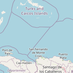
Map view of Monte Cristi National Park

Use this park location map to pinpoint Monte Cristi National Park in Dominican Republic, understand its exact geographic position, and read its mapped placement within the surrounding landscape more clearly.

Pigeon | © OpenStreetMap contributors

Location context for Monte Cristi National Park

Monte Cristi Province
Natural feature types

Explore the Geographic and Natural Landmark Collection for Monte Cristi National Park

Navigate through the diverse natural terrain and significant geographic landmarks associated with Monte Cristi National Park. MoriAtlas provides a structured data source for understanding the complex mesa, wetland, and coastal geography of this protected area in the Dominican Republic.
Recorded earthquake history

Review the Historical Earthquake Catalogue for Monte Cristi National Park

Browse the documented seismic history associated with the geography of Monte Cristi National Park. This MoriAtlas dataset allows for the examination of historical event records, including specific epicentre distances, magnitudes, and depths for occurrences near this coastal protected area.

Monte Cristi National Park Earthquakes

Catalogued events

55 events

Strongest magnitude

Magnitude 5.6

Most recent event

Nov 16, 2025

This history includes earthquakes recorded inside the park or within 50 km of its borders

Park atlas

Explore the regional spread of protected areas, comparing landscapes and park geography surrounding Monte Cristi National Park.

Discover More Protected Areas Near Monte Cristi National Park, Dominican Republic

After exploring Monte Cristi National Park, continue your geographic discovery by browsing other national parks and protected areas across the Dominican Republic's diverse landscapes. Comparing these protected areas provides valuable context on regional conservation efforts, highlighting how varied ecosystems are managed from coastlines to arid interiors.
National parkHaiti
About 34 km away#1 closest

West

Three Bays Protected Area National Park: Haiti's Extensive Marine and Coastal Protected Landscape

Mapped coral reefs, mangrove forests, and unique regional geography.

The Three Bays Protected Area in Haiti is a key national park established to conserve its vital marine and coastal environments. Covering over 75,000 hectares, it is the country's largest protected marine complex, encompassing extensive and healthy coral reefs, critical seagrass beds, and sprawling mangrove forests. This protected landscape provides essential ecosystem services and coastal protection, showcasing a significant portion of Haiti's natural heritage and regional geographic context along its northeastern shoreline.

Area
754.06 km²
Established
2014
IUCN
IV
Relief
Lowland
National parkDominican Republic
60 km away#2 closest

Southeast

José Armando Bermúdez National Park: Dominican Republic National Park Atlas and Landscape Context

Discover the mapped protected area and geographic setting of this Dominican Republic national park.

Gain an understanding of José Armando Bermúdez National Park as a distinct protected landscape within the Dominican Republic. This entry focuses on its role as a national park, providing geographic context and highlighting its mapped boundaries for atlas exploration. Explore the park's specific terrain and its place within the nation's conservation network.

Area
766 km²
Established
1956
IUCN
II
Relief
Mountain
National parkNord
About 68 km away#3 closest

West

Parc national historique - Citadelle, Sans Souci, Ramiers: A Caribbean Historic Landscape

Protected mountain terrain and historic fortifications in northern Haiti

This national park protects an expansive mountain massif characterized by the massive Citadelle La Ferrière and the ruins of Sans-Souci Palace. Beyond its architectural significance, the park safeguards essential karst cave networks, natural springs, and forested river corridors that shape the rugged topography of northern Haiti.

Area
252.86 km²
Established
1968
Relief
Mountain
Scope
Terrestrial
National parkHaiti
About 68 km away#4 closest

West

National History Park National Park: Haiti's Protected Landscape and Geographic Atlas

Discover the park's mapped terrain and protected land geography.

The National History Park serves as a critical protected area within Haiti, offering detailed insights into its unique landscape and geographic setting. As a designated national park, it provides valuable data for atlas-based exploration of protected territories. Users can investigate the park's mapped boundaries, its regional context within Haiti, and the characteristics of its natural terrain, enriching their understanding of conservation landscapes.

Area
25.28 km²
Established
1968
IUCN
IV
Relief
Mountain
National parkDominican Republic
About 93 km away#5 closest

Southeast

Pueblo Viejo National Park: Dominican Republic Colonial Ruins and Gold Mining Heritage

Explore early Caribbean colonization and its archaeological landscape.

Pueblo Viejo National Park stands as a crucial archaeological site in the Dominican Republic, preserving the remnants of Concepción de la Vega, a significant colonial settlement established during the era of Christopher Columbus. This national park offers a unique window into the beginnings of European presence and the first major gold extraction operations in the Americas. Examine the mapped foundations of its fortress and town structures, understanding the colonial urban planning and the historical geography of early Caribbean heritage.

IUCN
II
Access
Easy access
Scope
Terrestrial
Water
No major water
National parkDominican Republic
111 km away#6 closest

Southeast

Valle Nuevo National Park: Nearctic Highland Ecosystem and Glacial Landscapes

Mapped protected area in the Dominican Republic's Cordillera Central.

Valle Nuevo National Park in the Dominican Republic offers a rare glimpse into a Nearctic ecosystem within the Caribbean. Spanning 910 square kilometers in the Cordillera Central, it features dramatic mountain peaks like Loma Alto de la Bandera and distinctive glacial landforms. The park protects extensive Hispaniolan pine forests and cloud forest habitats, supporting remarkable endemic biodiversity and serving as a critical watershed for the region.

Area
910 km²
Established
1996
IUCN
II
Relief
Mountain
National parkDominican Republic
151 km away#7 closest

East

Los Haitises National Park: Dominican Republic Protected Landscape & Park Geography

Mapped terrain and protected area boundaries in the Dominican Republic.

Los Haitises National Park is a vital protected national park in the Dominican Republic, offering unique insights into the region's geography and natural landscapes. This page delves into its mapped boundaries, regional context, and the importance of its protected status for understanding Dominican Republic's conservation areas. Gain a structured view of this important natural landscape and its place within a broader geographic atlas.

Area
826 km²
Established
1976
IUCN
II
Relief
Upland
National parkIndependencia Province
About 159 km away#8 closest

South

La Gran Sabana National Park: National Park Identity and Geographic Mapping

Exploring protected landscapes and regional context.

This detail entry focuses on La Gran Sabana National Park, delineating its identity as a protected national park within Independencia Province. It provides essential context for understanding the park's mapped boundaries, its specific geographic setting, and its role within the natural landscape. Users can explore its atlas-relevant features and understand its place in the broader geography of the Dominican Republic.

Area
219.58 km²
Established
2009
IUCN
II
Relief
Lowland

Common questions about visiting, size, designation, and location context for Monte Cristi National Park

Monte Cristi National Park FAQs for park facts, access, geography, and protected area context

Find quick answers about Monte Cristi National Park, including protected-area facts, park geography, trail and visitor context, and how the park fits into its surrounding country and regional landscape.
MoriAtlas Explorer

Continue Your Protected Areas Search Across the Global Atlas

Deepen your exploration by continuing the structured search for national parks and protected areas worldwide. Utilize the comprehensive filtering capabilities to compare different conservation landscapes and refine your understanding of global park geography. Discover more about the distribution and characteristics of protected natural areas.

Global natural geography