Why Meseta la Galera Natural Monument stands out
Meseta la Galera is best known as a small but visually dramatic flat-topped mountain that rises directly from the urban landscape of Tovar, offering a rare combination of Andean geology, urban-adjacent forest, and cultural landmark. Its recognizable silhouette, capped by the Cristo Rey statue, has become a defining element of the town's skyline and identity. Equally important is its origin as a Quaternary fluvial geomorphological unit, a relatively unusual landform within this part of the Venezuelan Andes, which underlines why the area received formal natural monument protection.
Meseta la Galera Natural Monument history and protected-area timeline
Meseta la Galera was formally designated as a natural monument of Venezuela on 5 June 1992 by decree of President Carlos Andrés Pérez, under Decree No. 2352. The decree was later published in Gaceta Oficial No. 4548 (Extraordinaria) on 26 March 1993, formally entering the mesa into Venezuela's protected areas system. The motivation behind the protection was both geological, recognizing the landform as a singular Quaternary fluvial geomorphological unit, and environmental, shielding the forested mesa from encroachment such as illegal occupation and the expansion of coffee plantations, which had been a growing pressure on surrounding slopes.
During the 2000s, urban pressures on the protected area intensified as the city of Tovar expanded around the monument. In 2008, the Universidad de los Andes presented an ecotourism park proposal to the Tovar municipal council as part of a broader territorial ordering plan for the municipality. The proposal envisioned a large-scale park with several themed plazas, including spiritual and love-themed agoras, access via funicular or pedestrian ramps, and supporting parking infrastructure, but the plan drew criticism from conservationists concerned about its impact on the protected natural monument.
In 2010, INPARQUES rejected the ecotourism park proposal and initiated recovery measures for the monument. On 12 April 2010, the agency began physically demarcating the polygonal boundary of the protected area, starting with several of the established perimeter reference points, in response to ongoing encroachments. A reforestation program launched on 5 June 2010, the anniversary of the original protection decree, planted around 350 native trees of the Mocotíes Valley. Subsequent planting days followed on 4 August 2010, with around 120 additional trees, and on 26 November 2010, when the Public Ministry contributed approximately 600 more trees in collaboration with the Ministry of Environment and the Mission Árbol initiative.
Meseta la Galera Natural Monument landscape and geographic character
The defining feature of Meseta la Galera's landscape is its abrupt transition from steep slopes to a completely flat summit. The mountain behaves visually like a small tepuy, a tabletop massif more typical of southern Venezuela's Guiana Shield region, but located here in the Andean foothills of Mérida. The flat crown runs for approximately one kilometer in length and stands between 935 and 1055 meters above sea level, with the upper surface dropping just over a hundred meters from the highest to the lowest point on the plateau.
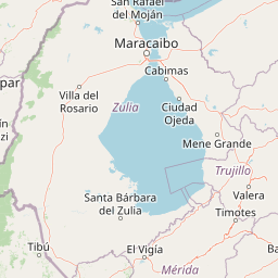
Below the mesa, the surrounding geography is shaped by the Mocotíes River, whose waters flow along the western side of the protected area and effectively separate Meseta la Galera from the parallel Loma de La Virgen ridge. The result is a tight, dramatic landscape in which river, foothill, urban edge, and flat-topped mountain converge within a small radius. The terrain feels less like a vast wilderness and more like a well-defined geomorphological theater, visible from much of Tovar.
The summit landscape is gentler than the surrounding slopes. It supports forest cover that gives the plateau its characteristic green mantle from a distance, and accommodates a forest reserve zone as well as religious and cultural infrastructure. The Mirador del Cristo Rey viewpoint is positioned in this upper zone, allowing visitors to read the surrounding geography, including the Mocotíes valley and the Loma de La Virgen, as a single continuous landscape framed by the Andean foothills.
Meseta la Galera Natural Monument ecosystems, habitats, and plant life
Meseta la Galera's ecological character is shaped by its position as an isolated patch of forested high ground surrounded by an expanding urban environment. Although only 95 hectares in size, the mesa's elevation range of roughly 935 to 1055 meters above sea level places it within a temperate Andean climatic belt, with mean annual temperatures in the high teens to low twenties of Celsius and annual rainfall on the order of 1018 millimeters. These conditions are favorable for a humid mountain forest at the limit between lowland and mid-elevation vegetation.
The plateau stands out ecologically because it functions as a green lung for the city of Tovar, maintaining tree cover and natural vegetation while the surrounding plain becomes more built up. The summit protected zone is designated as a forest reserve, signaling that the authorities prioritize forest continuity over the small area available. The dense vegetation visible from the city contributes not only to biodiversity but also to local microclimate moderation, air quality, and water retention on the slopes that drain toward the Mocotíes River.
In a regional context, the mesa's flora and fauna are linked to the broader biocultural landscape of the Valle del Mocotíes, the lower Andean valley in which Tovar sits. Reforestation programs on the monument have emphasized planting native tree species of this valley, suggesting that the ecological goal is to reinforce a typical local forest community rather than introduce exotic species. This makes the protected mesa a small but locally important reservoir of the original vegetation of the Mocotíes valley.
Meseta la Galera Natural Monument wildlife and species highlights
Specific fauna lists for Meseta la Galera are not extensively documented in available sources. However, the protected mesa's forested summit, mid-elevation climatic conditions, and connectivity with the surrounding Mocotíes valley corridor provide habitat for the typical bird, mammal, and insect communities of the lower Venezuelan Andes. Locally, the mesa is valued more for its role as a continuous patch of native vegetation and habitat refuge in an urbanizing landscape than for any single charismatic species, and protection efforts focus on preserving forest cover as the basis for that wider fauna.
Meseta la Galera Natural Monument conservation status and protection priorities
Conservation significance lies at the heart of Meseta la Galera's protected status. The monument was decreed under IUCN Category III protections and administered by INPARQUES specifically to defend a singular Quaternary fluvial geomorphological unit from degradation, including illegal occupation and the spread of coffee plantations onto its slopes. As a natural monument, it is meant to be preserved in a near-natural state rather than developed for extraction or large recreational use.
In recent years, the conservation challenge has shifted from outright land conversion to managing urban development pressures. INPARQUES's rejection of a 2008 ecotourism park proposal on the plateau, followed by the 2010 boundary demarcation and a multi-stage reforestation program, underscored the agency's commitment to maintaining the monument's ecological integrity. The reforestation efforts, which planted hundreds of native Mocotíes valley trees across 2010 with the support of national and local partners including Mission Árbol, UNEFA students, and the Public Ministry, also strengthened the mesa's role as a long-term forest refuge rather than a short-term amenity.
Meseta la Galera Natural Monument cultural meaning and human context
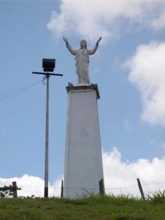
Meseta la Galera is interwoven with the cultural life of Tovar. The mesa is visible from much of the town and has become an emblem of local identity, with neighborhoods such as the La Galera urban area tying their names directly to the mountain. The Cristo Rey statue, a roughly 12-meter image of the Sacred Heart of Jesus at the highest point of the plateau, marks the convergence of natural landmark and religious devotion. Known locally as Cristo Rey, the monument functions both as a lookout and a pilgrimage and devotional site, giving the protected area a layered identity that intertwines Andean landscape with regional Catholic tradition.
Top sights and standout views in Meseta la Galera Natural Monument
The standout features of Meseta la Galera are its flat-topped Quaternary fluvial landform rising over the city of Tovar, its 95-hectare protected forest reserve functioning as an urban green lung, and the Cristo Rey statue and viewpoint crowning the summit at 1055 meters above sea level. Together these elements combine a singular geological formation, a working reforestation program with native valley species, and a cultural-religious landmark that has become inseparable from the identity of Tovar itself.
Best time to visit Meseta la Galera Natural Monument
Meseta la Galera sits in a temperate Andean climate zone with mean annual temperatures in the high teens to low twenties of Celsius and around 1018 millimeters of annual rainfall. Conditions are most comfortable for walking and viewpoint visits during the drier months of the Andean year, when fog and rainfall are less likely to obscure the views from the Cristo Rey mirador over the Mocotíes valley. The forested summit is pleasant to visit at any time of year thanks to the moderate temperatures, but wetter periods increase the chance of muddy access tracks along the northern and southern entrances to the monument.