Mori Atlas logo
Natural monumentMonumento Natural Teta de Niquitao-Guirigay

Examining the high-altitude terrain, glacial ridges, and páramo ecosystems of Trujillo state.

Monumento Natural Teta de Niquitao-Guirigay: Andean Protected Landscape and Regional Geography

Monumento Natural Teta de Niquitao-Guirigay represents a vital protected area within the Venezuelan Andes, centered on the towering summit that serves as the highest point in Trujillo state. This landscape features a complex transition from cloud forest to open subalpine páramo, punctuated by glacial lakes and sharp monoclinal ridges. The area preserves significant high-mountain habitats and geologic formations that define the regional geography of the Boconó and Urdaneta municipalities.

andean parkparamocloud foresthigh mountainglacial lakesprotected natural monument

Monumento Natural Teta de Niquitao-Guirigay

Natural monument

Park overview

Structured park overview, official facts, and landscape profile for Monumento Natural Teta de Niquitao-Guirigay

Monumento Natural Teta de Niquitao-Guirigay park facts, protected area profile, and essential visitor context

Review the core facts for Monumento Natural Teta de Niquitao-Guirigay, including designation, size, terrain, visitor scale, habitats, and operating context in one park-focused overview.

About Monumento Natural Teta de Niquitao-Guirigay

Monumento Natural Teta de Niquitao-Guirigay occupies a distinctive position in the northwestern reaches of the Venezuelan Andes, in Trujillo state. Designated as a natural monument in 1996, the protected area was created specifically to preserve the scenic and ecological value of a high-mountain landscape shaped by geological uplift and ancient glaciation. Its territory spans the municipalities of Boconó and Urdaneta, and it is closely associated with the approaches to the Teta de Niquitao peak from the town of Boconó and the villages of Tostós and Niquitao.

The defining feature of the protected area is the mountain itself, a sharp summit that crowns a broader system of ridges, slopes, and high plateaus. Glacial sculpting has left its mark across the terrain, producing the cirques, lakes, and rounded valley forms that today collect water for a network of streams descending from the high zone. The combination of rocky ridges, open páramo, and forested slopes creates the layered character that makes this corner of the Andes visually memorable and ecologically significant.

From a regional perspective, the monument is more than a high-altitude refuge; it acts as a guardian of water sources, native páramo vegetation, and wildlife adapted to the Andean highlands. Its administration by INPARQUES reflects a national recognition that this particular combination of geological architecture, páramo ecosystems, and cloud forest remnants deserved formal protection. For visitors and residents alike, the sight of the Teta rising above the Boconó valley remains a defining image of Trujillo state.

Quick facts and research context for Monumento Natural Teta de Niquitao-Guirigay

Monumento Natural Teta de Niquitao-Guirigay is a natural monument category protected area administered by INPARQUES in Trujillo state, Venezuela. It was created by official decree on 4 September 1996 and published in the Gaceta Oficial later that same year. The area covers the northwestern stretch of the Venezuelan Andes and includes the highest summit in Trujillo state.

Protection and recognition

Structured documentation of terrestrial protection scope and international recognition records

Monumento Natural Teta de Niquitao-Guirigay Protection Status and Terrestrial Designation Records

Monumento Natural Teta de Niquitao-Guirigay maintains documented terrestrial protection status within official conservation registries. Systematic record tracking provides transparent access to management scope and verified designation data for this protected area.

Protection details

Protection scope
Terrestrial
Transboundary protection
No
Park context

Deeper park guide and search-rich context for Monumento Natural Teta de Niquitao-Guirigay

Monumento Natural Teta de Niquitao-Guirigay history, landscape, wildlife, and travel context

Explore Monumento Natural Teta de Niquitao-Guirigay through its history, landscape character, ecosystems, wildlife, conservation priorities, cultural context, and seasonal travel timing in a structured park guide built for atlas discovery and search intent.

Why Monumento Natural Teta de Niquitao-Guirigay stands out

The park is best known for the Teta de Niquitao peak itself, the tallest mountain in Trujillo state, rising out of a classic Andean landscape of glacial ridges, páramo plateaus, and small glacial lakes. Its monoclinal crests, high-altitude wetlands, and surviving patches of cloud forest give the area a layered ecological identity that transitions from humid mountain forest up into open subalpine páramo.
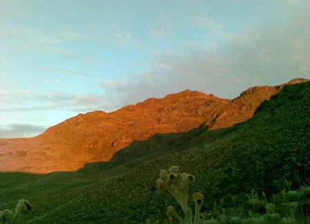
A mountain peak under golden hour sunlight, with green, grassy slopes in the foreground.
The Teta de Niquitao peak illuminated by sunset light.

Monumento Natural Teta de Niquitao-Guirigay history and protected-area timeline

The monument was officially established through Decree No. 1.473, dated 4 September 1996, and published in the Gaceta Oficial No. 36.063 on 11 October 1996. Its creation was driven by the need to protect and conserve landscapes formed by monoclinal crests, páramo formations, and remnants of cloud forest in the Venezuelan Andes.

Responsibility for managing the area falls to the Instituto Nacional de Parques, INPARQUES, the national body in charge of safeguarding both natural and cultural resources across Venezuela's protected areas. Following its designation, the site joined the broader national network of natural monuments and has remained a focal point of high-Andean conservation in Trujillo state.

Monumento Natural Teta de Niquitao-Guirigay landscape and geographic character

The landscape of Teta de Niquitao-Guirigay is classic high-Andean in character, dominated by sharp crests, deep valleys, and broad páramo surfaces shaped by ancient glacial action. Altitudes within the protected area range roughly from 3,200 meters up to the summit of the Teta de Niquitao at about 4,006 meters above sea level, which is the highest point in Trujillo state.

Access roads reaching toward the area climb to approximately 3,400 meters, giving visitors a sense of the steep ascent from the Boconó valley below. The terrain includes monoclinal ridges where resistant rock layers tilt in long, narrow crests, and these are softened by the rounded forms of glacial valleys. Among the most distinctive landscape elements are the small glacial lakes, including the Laguna de la Teta and the Laguna del Arenal, which sit in basins carved during past ice ages.

Geologically, the area is composed of metamorphic and sedimentary rocks belonging to the Sierra Nevada formation, a reminder of the deep geological history that shaped this portion of the Andes.

Monumento Natural Teta de Niquitao-Guirigay ecosystems, habitats, and plant life

Ecologically, the protected area represents a fascinating transition between two distinct high-Andean environments. Lower slopes still carry remnants of mountain forests, including examples of cloud forest, where humidity supports a denser and richer vegetation than the open highlands above. Higher elevations give way to páramo and subalpine páramo, characterized by low, hardy vegetation adapted to cold temperatures, intense sunlight, and frequent cloud cover.

A defining plant of the páramo in this area is the frailejón, a signature Andean species recognizable by its rosette form and silvery foliage. Other characteristic plants include huesito de páramo, tabacote, chipiador, abrojo, and vira vira, which together create the soft, low-cover landscape typical of Venezuelan páramos. The combination of forest and páramo makes the monument an unusually complete representation of high-altitude Andean habitats.

Monumento Natural Teta de Niquitao-Guirigay wildlife and species highlights

The mix of páramo and cloud forest habitats supports a notable diversity of Andean wildlife. Among the most iconic mammals present is the oso frontino, the Andean spectacled bear, one of South America's most emblematic and vulnerable large mammals. Smaller mammals such as the cachicamo, an armadillo, the páramo rabbit, and the lapa paramera also inhabit the protected landscape.

Birdlife is similarly rich and adapted to both forest and open páramo environments. The área is home to the águila real, the golden eagle soaring above the high ridges, along with species such as the pato serrano of high-Andean waters, the cotua negra, and the picón. Together these species highlight the importance of the monument as a refuge for highland fauna that depends on intact páramo and forest habitats.

Monumento Natural Teta de Niquitao-Guirigay conservation status and protection priorities

Conservation value at Teta de Niquitao-Guirigay centers on the protection of three interconnected natural assets: monoclinal geological formations, páramo ecosystems, and remaining fragments of cloud forest. Each of these is considered threatened in the broader Andean context, and their concentration in a single protected unit gives the monument particular importance for long-term habitat preservation.

The area also plays a role in safeguarding water sources for surrounding communities, as its páramo landscapes and glacial features feed streams such as the Río Cabimbú, the Quebrada de la Teta, the Quebrada de Tuñame, and the Quebrada de Tomón. Managed by INPARQUES, the monument forms part of Venezuela's national system of protected areas dedicated to maintaining the ecological integrity of the Andes.

Monumento Natural Teta de Niquitao-Guirigay cultural meaning and human context

For the people of Trujillo state, the Teta de Niquitao is more than a geographic landmark. It is a defining emblem of regional identity, frequently cited as the most recognizable natural feature of the Andean portion of the state. The surrounding parishes and villages, including Niquitao and Tostós, are closely tied to the mountain's presence in everyday life, folklore, and local imagination.

Top sights and standout views in Monumento Natural Teta de Niquitao-Guirigay

The protected area's strongest points of distinction are its altitude and its layered ecology. The summit at over 4,000 meters is the highest in Trujillo state and stands out as a focal point of the surrounding Andes. At its base, glacial lakes and páramo plateaus carry a quieter, more open beauty, while the surviving cloud forest patches shelter some of the most threatened wildlife in the region, including the Andean spectacled bear.

Best time to visit Monumento Natural Teta de Niquitao-Guirigay

The high-Andean character of the park shapes its seasonal appeal. Dry-season months typically offer clearer skies and better visibility of the summit and surrounding páramo, which is favorable for landscape-focused visits and photography. The rainy season brings lusher vegetation and more active páramo landscapes, though it can also bring cloud cover that obscures the higher ridges. Cooler temperatures throughout the year reflect the elevation, and visitors should expect Andean conditions regardless of season.

Monthly climate preview

Long-term representative monthly temperature and precipitation data for Trujillo protected terrain

Monumento Natural Teta de Niquitao-Guirigay Climate Normals and Annual Temperature Rhythms

Monumento Natural Teta de Niquitao-Guirigay records measured long-term temperature ranges alongside twelve-month precipitation averages based on representative coordinate sampling. Analyzing these recorded climatic shifts provides structural insight into the protected area's annual environmental patterns across monthly intervals.
Annual mean17 °C
16 °C18 °C
Jan16°
Feb17°
Mar17°
Apr18°
May17°
Jun17°
Jul16°
Aug17°
Sep17°
Oct17°
Nov17°
Dec16°
Warmest month
April

17.5 °C

Coolest month
January

16 °C

Wettest month
June

6.6 mm/day

Driest month
January

0.7 mm/day

Park location guide

Geography guide, regional context, and park location map for Monumento Natural Teta de Niquitao-Guirigay

Monumento Natural Teta de Niquitao-Guirigay park geography, regions, and map view in Venezuela

Understand where Monumento Natural Teta de Niquitao-Guirigay sits in Venezuela through a broader geographic reading of the surrounding landscape, nearby location context, and its mapped position within the national park landscape.

How Monumento Natural Teta de Niquitao-Guirigay fits into Venezuela

Venezuela is a country in northern South America with coastline along the Caribbean Sea and Atlantic Ocean. It borders Colombia, Brazil, Guyana, and Trinidad and Tobago. The country has an area of approximately 916,445 km² and a population of about 31.8 million. Caracas is the capital and largest city. Venezuela consists of 23 states and the Capital District.

Wider geography shaping Monumento Natural Teta de Niquitao-Guirigay in Venezuela

Venezuela is located on the northern coast of South America. The continental territory is bordered by the Caribbean Sea and Atlantic Ocean to the north, Colombia to the west, Brazil to the south, and Guyana to the east. Trinidad and Tobago lies to the northeast. The country includes various islands and islets in the Caribbean Sea known as the Federal Dependencies.

Map view of Monumento Natural Teta de Niquitao-Guirigay

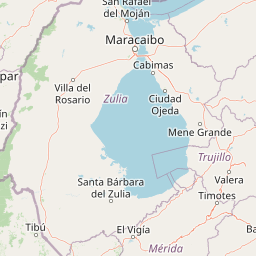
Use this park location map to pinpoint Monumento Natural Teta de Niquitao-Guirigay in Venezuela, understand its exact geographic position, and read its mapped placement within the surrounding landscape more clearly.

Pigeon | © OpenStreetMap contributors

Location context for Monumento Natural Teta de Niquitao-Guirigay

Trujillo

Visual exploration of high Andean terrain, glacial ridges, and páramo habitats

Monumento Natural Teta de Niquitao-Guirigay Photos and Protected Landscape Imagery

Visual records capture the rugged topography, glacial formations, and high-altitude habitats defining Monumento Natural Teta de Niquitao-Guirigay. Examining protected area imagery provides deeper insight into the ecological character of the Venezuelan Andes.

A mountain peak under golden hour sunlight, with green, grassy slopes in the foreground.

Park atlas

Compare surrounding Andean terrain, high-altitude páramo, and regional protected areas

Explore Other Parks Near Monumento Natural Teta de Niquitao-Guirigay

Discover related national parks and protected areas located near Monumento Natural Teta de Niquitao-Guirigay in the Venezuelan Andes. Expanding the geographic comparison reveals broader regional ecosystems, glacial landforms, and high mountain topography across the surrounding mountain terrain.
National parkVenezuela
About 14 km away#1 closest

Southwest

Sierra La Culata National Park: Protected Landscape Atlas of the Venezuelan Andes

Explore the páramo ecosystems and mapped terrain of this Venezuelan national park.

Sierra La Culata National Park offers a profound look into the unique geography of the Venezuelan Andes. This protected national park is characterized by its expansive páramo ecosystems, dramatic mountain peaks, and glacial lagoons, creating a distinctive high-altitude wilderness. Use this atlas-focused entry to understand the park's mapped boundaries and its significant role within the region's natural landscape context.

Area
2,004 km²
Established
1989
IUCN
II
Relief
Mountain
National parkTrujillo
About 18 km away#2 closest

South

Parque nacional Dr. José Gregorio Hernández: Andean Mountain and Watershed Geography

High-altitude protected habitats in the Venezuelan Andes

This national park protects a vast stretch of Andean terrain, serving as an essential ecological link between major mountain reserves. Its steep ridges and river valleys represent a critical habitat for the spectacled bear while securing the water sources of regional watersheds.

Area
505 km²
Established
2021
IUCN
II
Relief
Mountain
Watercolor painting showing green hills, a river, and distant mountains under a light sky
National parkVenezuela
About 30 km away#3 closest

South

Sierra Nevada National Park: Venezuela's Majestic Alpine Protected Landscape and Park Boundaries

Explore the highest peaks and glacial terrain of this Venezuelan national park.

Delve into Sierra Nevada National Park, a premier protected area situated in the high Venezuelan Andes. This national park protects a vast expanse of dramatic alpine terrain, including Pico Bolívar and numerous glacial valleys. Understand its mapped boundaries and the unique paramo and cloud forest ecosystems that define this significant natural landscape within Venezuela, offering rich context for atlas-style geographic discovery.

Area
2,764.46 km²
Established
1952
IUCN
II
Relief
Mountain
Watercolor painting of a lake surrounded by soft green hills and coniferous trees with a pale pink sky.
National parkTrujillo
About 34 km away#4 closest

East

Parque nacional Guaramacal: Mapped Protected Landscapes and Andean Mountain Geography

Defining the boundaries and ecological terrain of the Ramal de Guaramacal.

Parque nacional Guaramacal captures a remarkable ecological transition in a compact space, rising from sub-Andean forests to summits above 3,000 meters. This record outlines the park geography, covering the steep ridgelines, glacial lake basins, and the endemic-rich cloud forest zones that define this significant Venezuelan protected area.

Area
215 km²
Established
1988
IUCN
II
Relief
Mountain
National parkVenezuela
About 35 km away#5 closest

East

General Cruz Carrillo en Guaramacal National Park: Venezuela's National Park Landscape

Mapped protected areas and regional geography.

Delve into the protected landscape of General Cruz Carrillo en Guaramacal National Park, a national park situated in Venezuela. This page provides essential geographic context, focusing on the park's mapped boundaries and its role as a protected natural area. Understand its place within the regional geography and discover its unique landscape characteristics, offering a foundation for detailed atlas exploration.

National parkVenezuela
About 49 km away#6 closest

Northeast

Dinira National Park: Protected Watershed and Andean Mountain Landscape

Explore its rugged terrain and páramo ecosystem.

Dinira National Park is a significant protected area in Venezuela, covering rugged Andean terrain vital for watershed protection. This national park features dramatic mountain landscapes, including the Humocaro Mountains and the Los Nepes páramo zone, supporting diverse cloud forest and high-altitude ecosystems. Understanding Dinira National Park offers insight into the geographic context of the Cordillera de Mérida and its hydrological importance.

Area
453.28 km²
Established
1988
IUCN
II
Relief
Mountain
National parkLara State
About 107 km away#7 closest

Northeast

Yacambú National Park National Park: Protected Cloud Forest Landscape in Lara State

Mapped terrain and significant orchid diversity in Venezuela's Andean foothills.

Yacambú National Park is a significant national park in Venezuela's Lara State, protecting crucial humid cloud forest ecosystems in the Andean foothills. The park's terrain is defined by the mountainous topography of the Portuguesa Mountain Range, supporting a rich diversity of flora, including numerous orchid species. Its role in watershed protection for nearby regions underscores its importance as a conserved natural landscape with vital ecological functions.

Area
146 km²
Established
1962
IUCN
II
Relief
Mountain
National parkVenezuela
About 115 km away#8 closest

Northeast

El Guache National Park: Venezuela's Protected Andean Foothill National Park

Map exploration of vital river basins and natural landscapes.

El Guache National Park is a protected national park in Venezuela, safeguarding the headwaters of five key rivers. Its landscape comprises mountainous terrain within the Andean foothills, crucial for watershed protection and regional biodiversity. This entry provides detailed geographic context, allowing for an atlas-style exploration of the park's mapped boundaries and its role as a vital protected area.

Area
122 km²
Established
1992
IUCN
II
Relief
Mountain

Common questions about visiting, size, designation, and location context for Monumento Natural Teta de Niquitao-Guirigay

Monumento Natural Teta de Niquitao-Guirigay FAQs for park facts, access, geography, and protected area context

Find quick answers about Monumento Natural Teta de Niquitao-Guirigay, including protected-area facts, park geography, trail and visitor context, and how the park fits into its surrounding country and regional landscape.
MoriAtlas Explorer

Continue Your Protected Areas Search Across the Global Atlas

Deepen your exploration by continuing the structured search for national parks and protected areas worldwide. Utilize the comprehensive filtering capabilities to compare different conservation landscapes and refine your understanding of global park geography. Discover more about the distribution and characteristics of protected natural areas.

Global natural geography